Hurricane Agnes
-
Posts
9,344 -
Joined
Content Type
Profiles
Blogs
Forums
American Weather
Media Demo
Store
Gallery
Everything posted by Hurricane Agnes
-
Saving that for when the cold front comes blasting through! Temp still 36 and dp now up to 34. Finally moistened up enough for some visible light rain. Bucket hasn't tipped yet though.
-
Am getting some intermittent light drizzle but every time I stick my head out the door, I don't see/feel anything but it has wet much of the walk. Still not enough to be measurable. Temp still 36 with dp 33.
-
E PA/NJ/DE Winter 2022-2023 OBS Thread
Hurricane Agnes replied to Ralph Wiggum's topic in Philadelphia Region
Decided to go ahead and make an OBS thread for this since we have some NW/Poconos area and LV posters who may see some measurable that will hang around for awhile. -
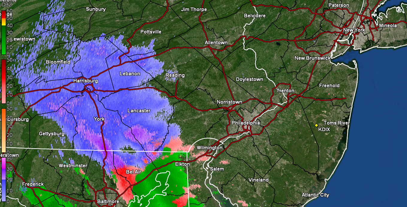
Since we do have a variety of forum posters in areas that will see snow/sleet/ZR - at least initially and on the backend, plus there is a flood threat, along with some potential advisory-level winds and possibly record breaking cold, decided to go ahead and make an obs thread. Currently misty and mostly virga and 36 with dp 32 here in NW Philly.
-
E PA/NJ/DE Winter 2022-2023 OBS Thread
Hurricane Agnes replied to Ralph Wiggum's topic in Philadelphia Region
My Upper Darby sis texted about 5 minutes ago about getting some sleet so some of the yellows on the radar may be ip. I have droplets on the walk, so must have had a drive-by bunch of splats of something (it wasn't actively doing anything when I popped out to investigate). Temp is 36 with dp 32. ETA - my Wyndmoor sis texted to say she had some sleet so since I'm a couple miles SE of her, my spats may have been ip-related although I seem to doubt it as she is at the bottom of a rolling hill (I am actually "above" her in elevation) and she always runs colder than me as the cold air will drain down and settle along her location. -
E PA/NJ/DE Winter 2022-2023 OBS Thread
Hurricane Agnes replied to Ralph Wiggum's topic in Philadelphia Region
From Mt. Holly - Temp still creeping up here and I'm currently at 35 with dp also up to 31. I had just popped out about 20 minutes ago and have virga over me but you could almost feel and breath the chilled mist in the air! -
E PA/NJ/DE Winter 2022-2023 OBS Thread
Hurricane Agnes replied to Ralph Wiggum's topic in Philadelphia Region
Stuff on the radar to the west. Currently 33 (temp has been creeping up from a 29 low at midnight), with dp 27.
-
E PA/NJ/DE Winter 2022-2023 OBS Thread
Hurricane Agnes replied to Ralph Wiggum's topic in Philadelphia Region
That may turn out to be a unique record-breaking bomb cyclone. As it is, this is just the first month of met winter and historically the snow was more a January-February (peak winter) thing. In fact recently, we have been getting more in March too as if we were in Colorado. I made it up to 39 today after a low of 25 and it's currently 30 with a dp that has slowly crept up this afternoon from the low 20s to 24. -
E PA/NJ/DE Winter 2022-2023 OBS Thread
Hurricane Agnes replied to Ralph Wiggum's topic in Philadelphia Region
You forgot this illustration --> -
E PA/NJ/DE Winter 2022-2023 OBS Thread
Hurricane Agnes replied to Ralph Wiggum's topic in Philadelphia Region
Flood Watch just issued for part of the CWA - Flood Watch Flood Watch National Weather Service Mount Holly NJ 327 PM EST Wed Dec 21 2022 DEZ001-NJZ016>019-PAZ070-071-102-104-106-220830- /O.NEW.KPHI.FA.A.0006.221222T1800Z-221223T1200Z/ /00000.0.ER.000000T0000Z.000000T0000Z.000000T0000Z.OO/ New Castle-Salem-Gloucester-Camden-Northwestern Burlington-Delaware- Philadelphia-Eastern Chester-Eastern Montgomery-Lower Bucks- Including the cities of Wilmington, Philadelphia, Morrisville, Media, Norristown, Kennett Square, Camden, Glassboro, Mount Holly, Doylestown, Cherry Hill, Moorestown, Pennsville, Lansdale, and West Chester 327 PM EST Wed Dec 21 2022 ...FLOOD WATCH IN EFFECT FROM THURSDAY AFTERNOON THROUGH FRIDAY MORNING... * WHAT...Flooding caused by excessive rainfall is possible. * WHERE...Portions of northern Delaware...southern New Jersey...and southeast Pennsylvania...including the following areas...in northern Delaware...New Castle. In southern New Jersey...Camden, Gloucester, Northwestern Burlington, and Salem. In southeast Pennsylvania...Delaware, Eastern Chester, Eastern Montgomery, Lower Bucks, and Philadelphia. * WHEN...From Thursday afternoon through Friday morning. * IMPACTS...Excessive runoff may result in flooding of rivers, creeks, streams, and other low-lying and flood-prone locations. Creeks and streams may rise out of their banks. Flooding may occur in poor drainage and urban areas. * ADDITIONAL DETAILS... - http://www.weather.gov/safety/flood $$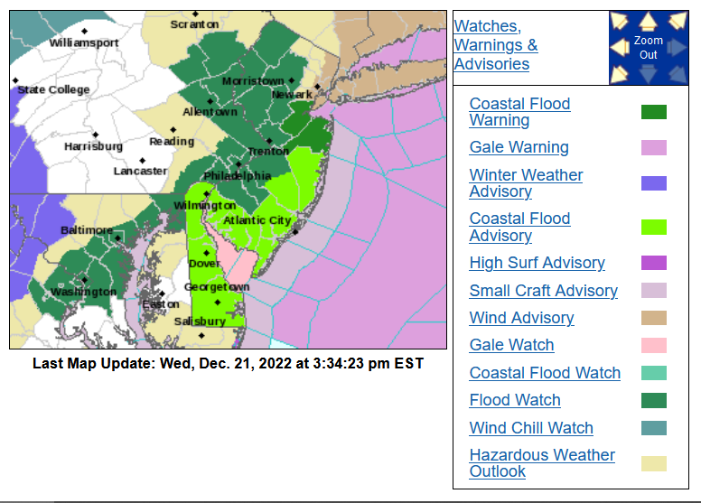
-
E PA/NJ/DE Winter 2022-2023 OBS Thread
Hurricane Agnes replied to Ralph Wiggum's topic in Philadelphia Region
The Korean War (UN police action) Armistice Treaty was finally signed in 1953, so they still had that need! I grew up hearing about the "rolling hills of Chester County" yet you had "rolling steel" there too, with plants that had popped up along the rivers and creeks for over a century and a half. Another interesting article on that steel plant in Coatesville. And IIRC, W.T. Gordon's son worked at that plant back in the late 1800s/early 1900s. -
E PA/NJ/DE Winter 2022-2023 OBS Thread
Hurricane Agnes replied to Ralph Wiggum's topic in Philadelphia Region
Let me posit something - and it is related to the deep dive you recall I did of the Coatesville observer W.T. Gordon. Oddly enough I just never knew there were steel plants just outside of Philly in Coatesville because so much focus was always put on U.S. Steel in Pittsburgh and Bethlehem Steel up in the ABE area. I should have probably known better given we had the big Budd plant here in the city cranking out steel parts for cars, planes, and for what was more talked about when I was growing up - trains. When you look at your gathered temp rises and falls, you'll see that interestingly enough, they correspond with a build up leading to a peak right during the main part of WW2. The Coatesville plant was apparently making rolled steel plates where there was mention in an article I just read, would eventually be used in shipbuilding. Of course we had the Navy Yard here down in South Philly with a massive amount of shipbuilding going on all during that period. I.e., all the "Rosie the Riveters". I even had one of my aunts and her friends who briefly worked down at the Navy Yard during that period in the '40s. Once the war was over, boom! All that heavy manufacturing dropped off precipitously and eventually switched to a different type manufacturing output - homes and suburban "office parks"! And as the suburban developments expanded, someone "paved paradise and put up a parking lot" creating some mini-heat islands where they didn't exist before. This was all the post-WWII migration from the cities to the rim counties and eventually into what was dubbed "ex-burbia" (the more rural farm areas). With the recognition of that impact, you have more environmental awareness now and all those undeveloped and former rural farming areas stripped for development, have been slowly replanted, and that has helped to mitigate what was overall warming trend in that area's microclimate. In any case, as my obs - after a 29 low yesterday, I made it up to a breezy 39 as a high. It's currently 28 and clear with dp 20. -
E PA/NJ/DE Winter 2022-2023 OBS Thread
Hurricane Agnes replied to Ralph Wiggum's topic in Philadelphia Region
There's a good write-up for next week here - https://www.severe-weather.eu/global-weather/coldest-arctic-airmass-winter-season-major-storm-christmas-snow-forecast-united-states-canada-mk/ It did confirm to me that the lakes are still mostly ice-free so there is still potential for big lake effect snow events (some that could send streamers into the northern CWA if the winds blow the right way). This is definitely La Nina-ish weather. -
E PA/NJ/DE Winter 2022-2023 OBS Thread
Hurricane Agnes replied to Ralph Wiggum's topic in Philadelphia Region
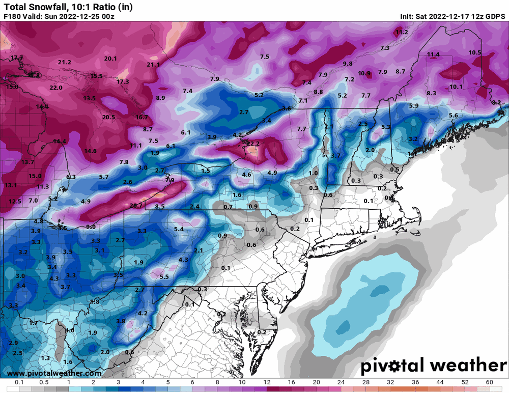
6z GFS 2nd verse, same as the 1st...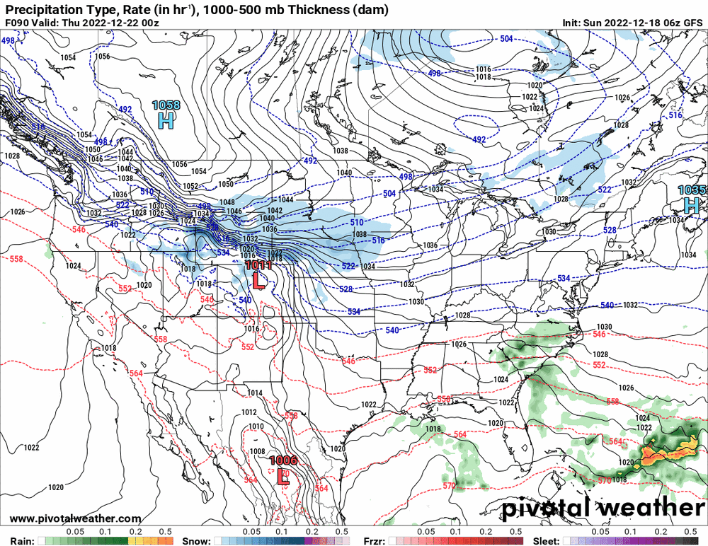
-
E PA/NJ/DE Winter 2022-2023 OBS Thread
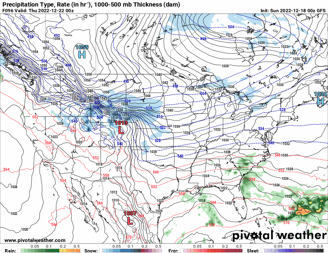
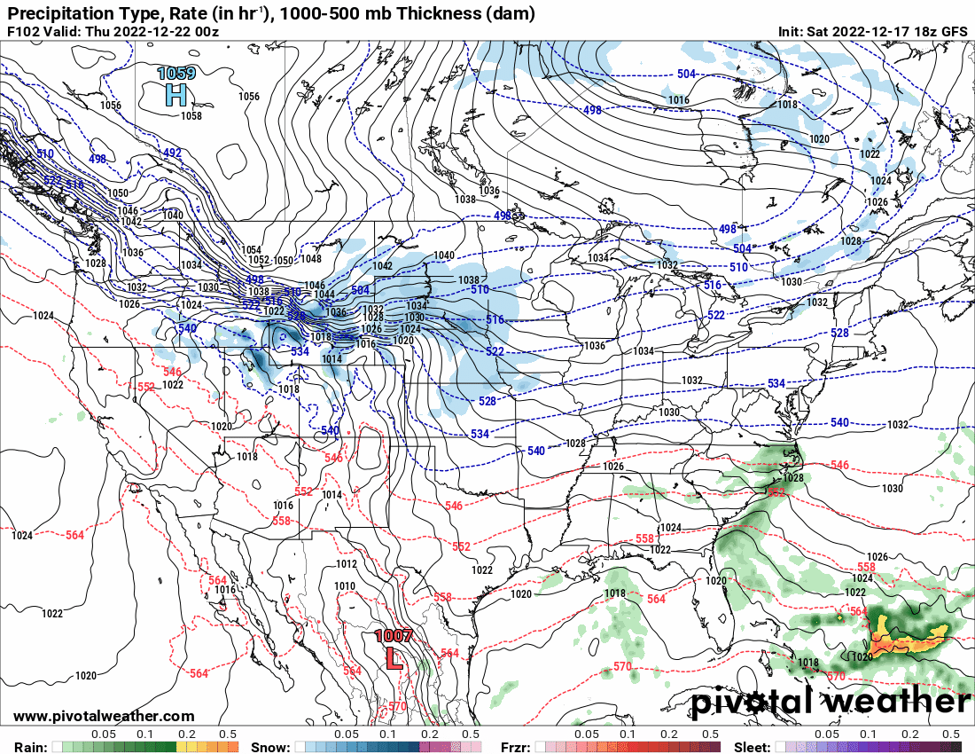
Hurricane Agnes replied to Ralph Wiggum's topic in Philadelphia Region
0z GFS did move the system east making it more the apps runner but like the other globals, is showing some kind of overrunning rain ahead of the arctic front.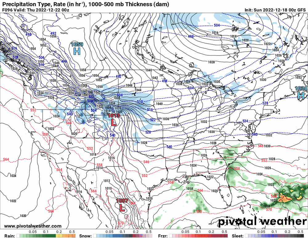
-
E PA/NJ/DE Winter 2022-2023 OBS Thread
Hurricane Agnes replied to Ralph Wiggum's topic in Philadelphia Region
It may run into drier air and evaporate. Temp here is 39 with dp 26....
-
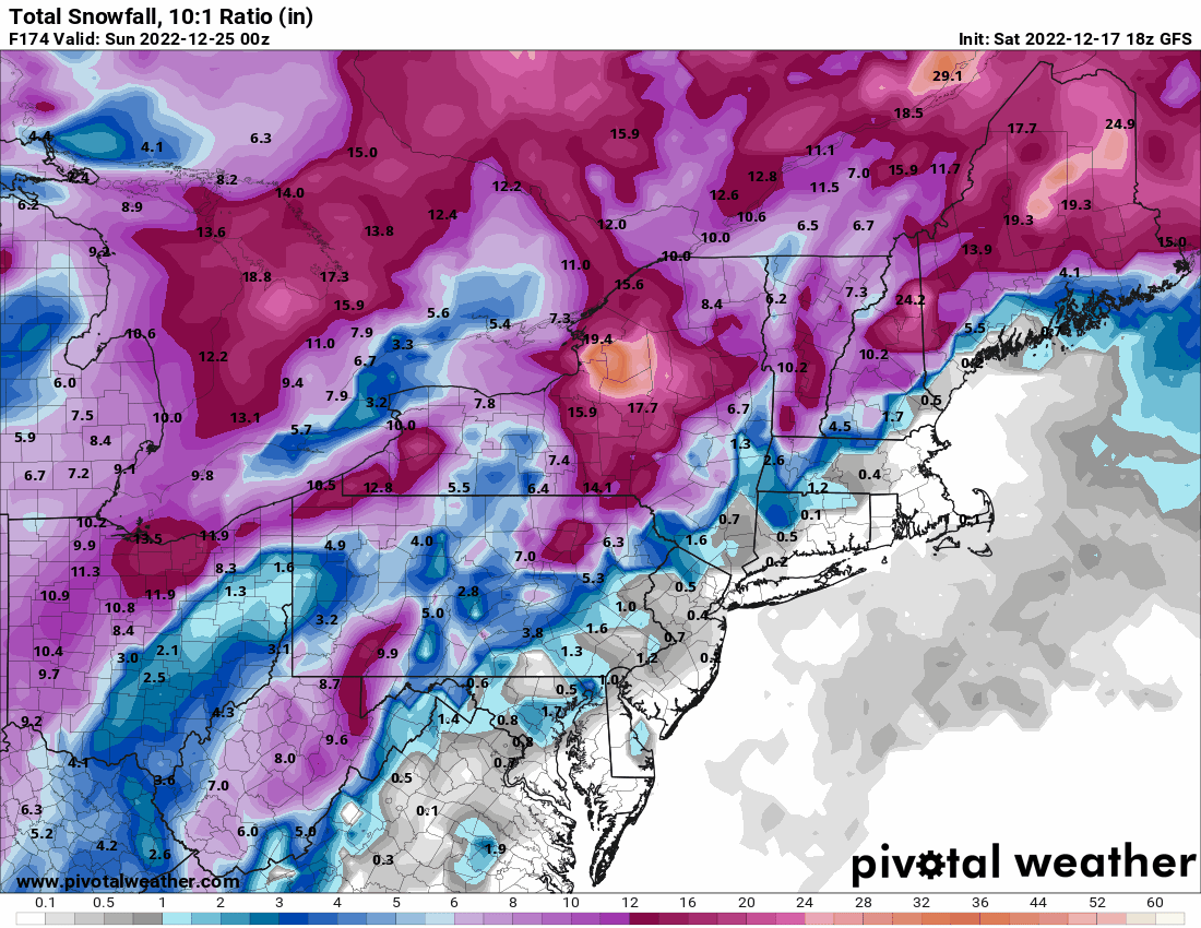
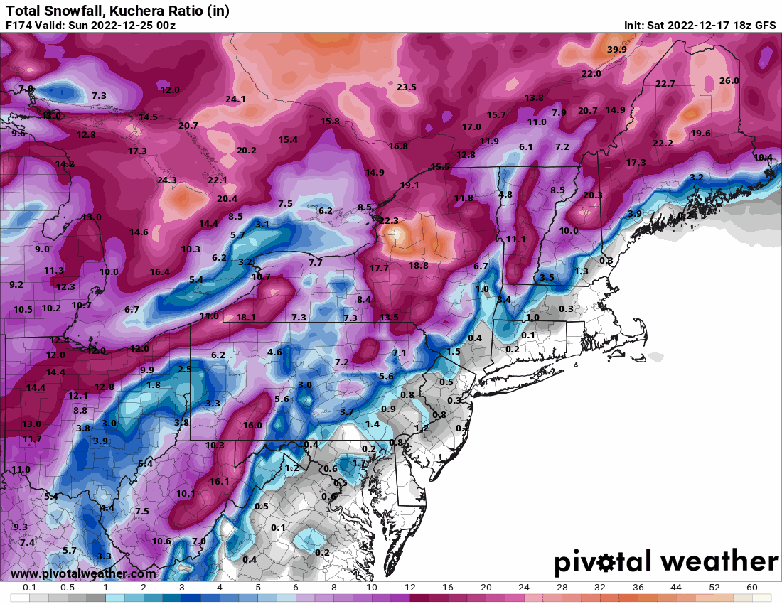
E PA/NJ/DE Winter 2022-2023 OBS Thread
Hurricane Agnes replied to Ralph Wiggum's topic in Philadelphia Region
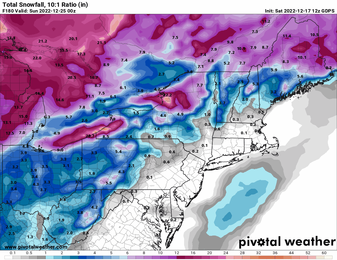
18z GFS has a buncha take-your-pick storms rolling along the bottom of that arctic high... You know it's bad when the clown map has less than the 10:1.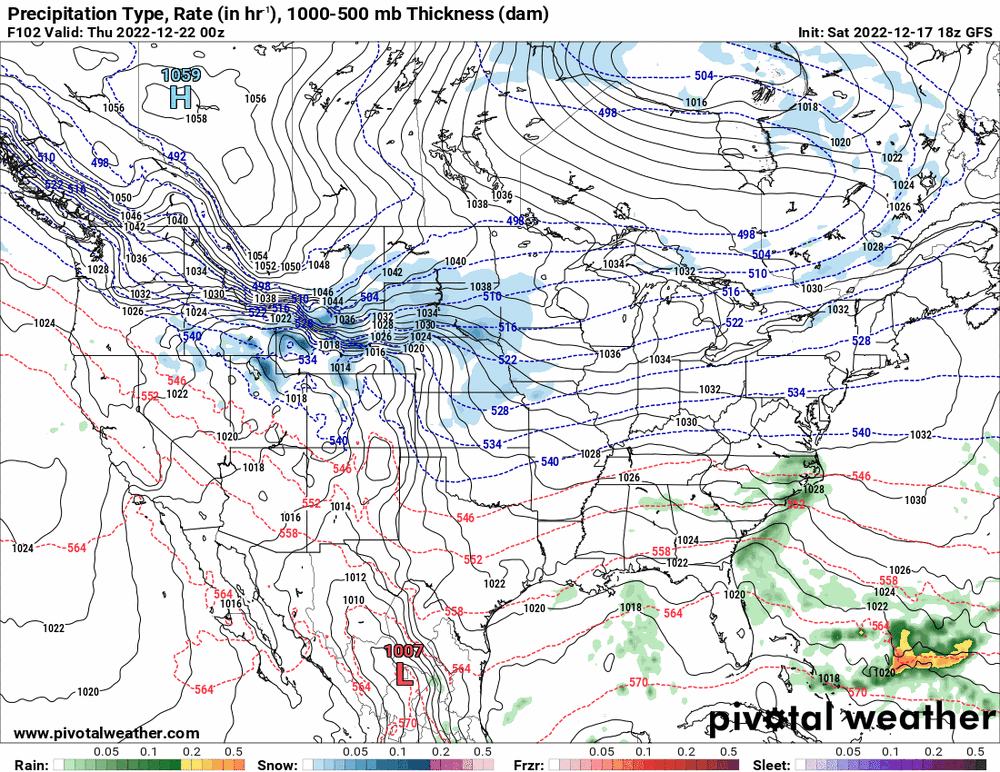


-
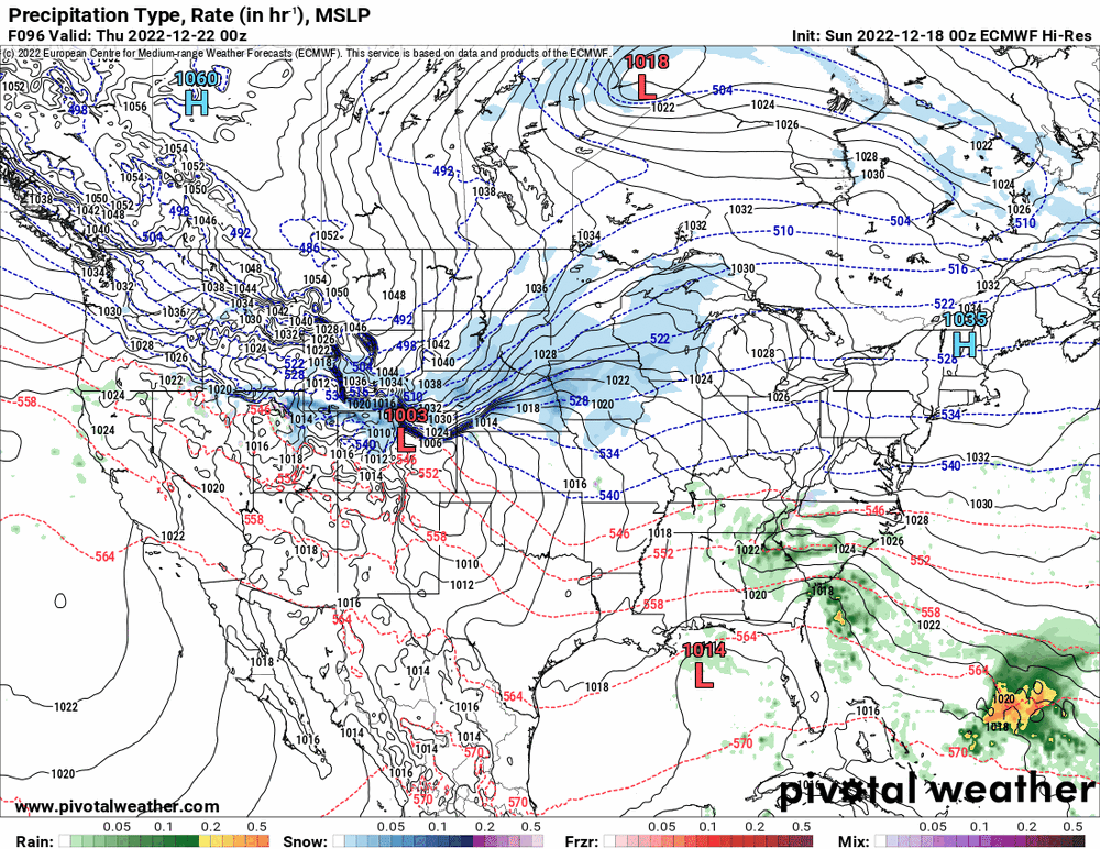
E PA/NJ/DE Winter 2022-2023 OBS Thread
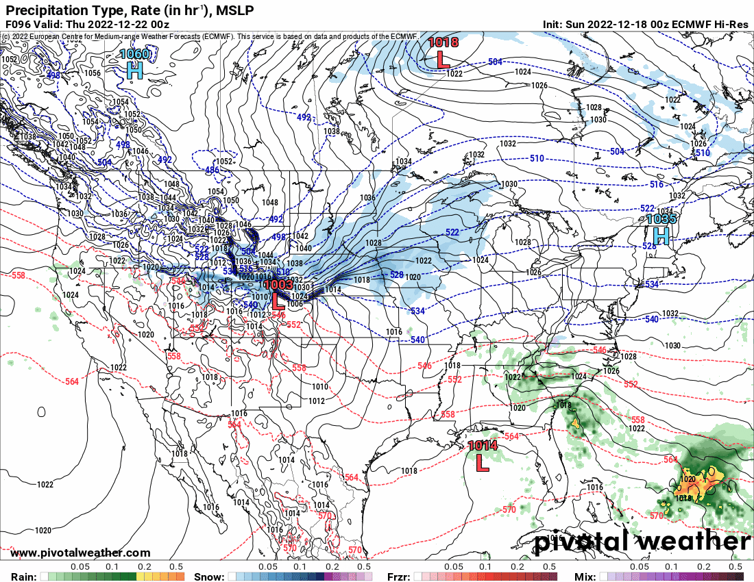
Hurricane Agnes replied to Ralph Wiggum's topic in Philadelphia Region
Ukie has some of the storm in range but seems to be on the arctic blast train...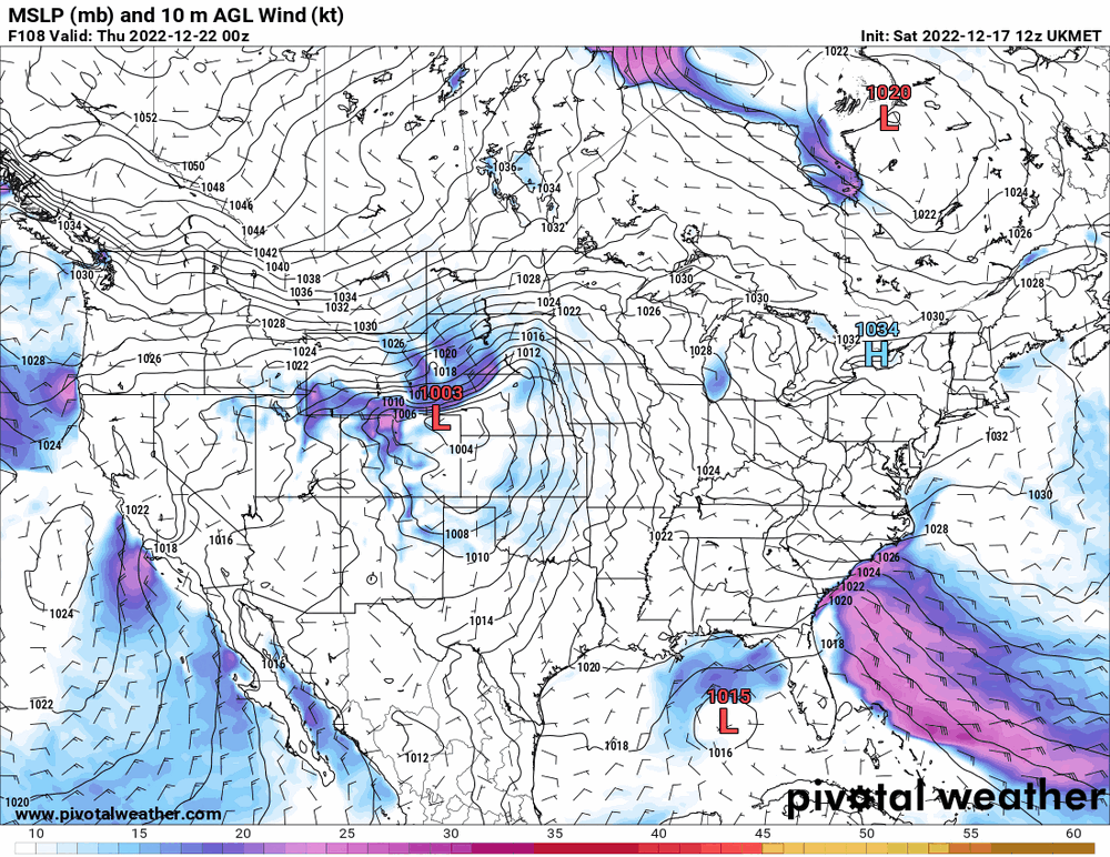
-
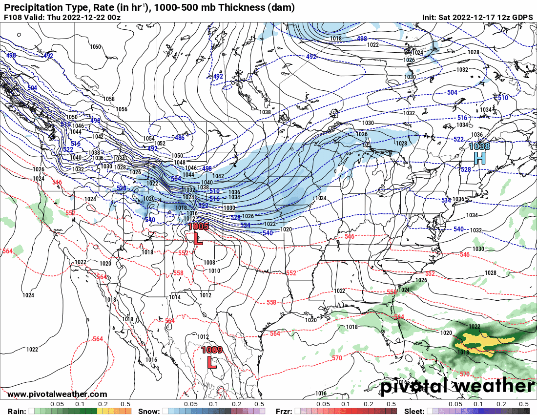
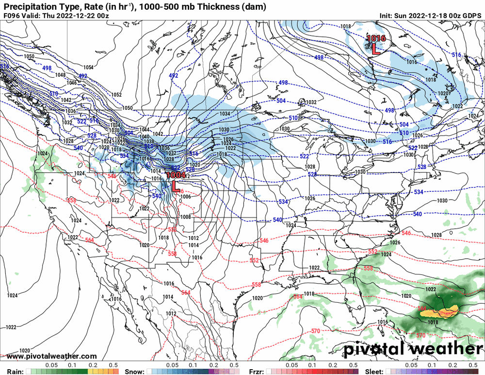
E PA/NJ/DE Winter 2022-2023 OBS Thread
Hurricane Agnes replied to Ralph Wiggum's topic in Philadelphia Region
12z Canadian doing the same amplification scheme.
-
I caved and being it was for a good cause, I went on and bought the Iggles "A Philly Special Christmas" album - https://phillyspecialchristmas.com/ Since yesterday was their "final" (in quotes) offering, it won't be delivered until sometime in February but that's okay.... The album cover artwork is a riot. What was also hilarious was the vid of the players who got together to make that (over this past summer) and some behind the scenes of their rehearsals and recording sessions! This sortof suggests to me why they might be 12-1. Definitely some great camaraderie there.
-
E PA/NJ/DE Winter 2022-2023 OBS Thread
Hurricane Agnes replied to Ralph Wiggum's topic in Philadelphia Region
They both do try to spin up some kind of coastal thing though but both have that bomb-ey low out west.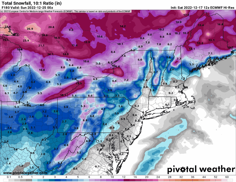
-
E PA/NJ/DE Winter 2022-2023 OBS Thread
Hurricane Agnes replied to Ralph Wiggum's topic in Philadelphia Region
!2z EC doing a cutter... I think both globals are looking at that arctic amplification. Will have to see if that relaxes later next week.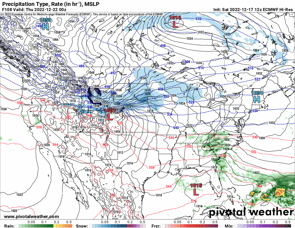
-
E PA/NJ/DE Winter 2022-2023 OBS Thread
Hurricane Agnes replied to Ralph Wiggum's topic in Philadelphia Region
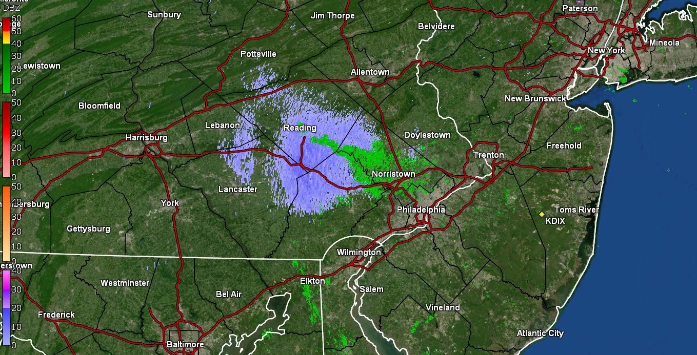
12z Euro is running so will see which way that goes! As an obs, my low was 35 this morning and my high was 43 just after 11:30 this morning and then the CAA started coming in. Am currently 41 with dp 27 and an unsettled sky. -
E PA/NJ/DE Winter 2022-2023 OBS Thread
Hurricane Agnes replied to Ralph Wiggum's topic in Philadelphia Region
The unevenness of the precipitation this year highlights how we were feast or famine. We are already about a foot above normal for rainfall this year. -
E PA/NJ/DE Winter 2022-2023 OBS Thread
Hurricane Agnes replied to Ralph Wiggum's topic in Philadelphia Region
I think this was the "a lot of rain" option run that Mt. Holly mentioned this morning.