Hurricane Agnes
-
Posts
9,344 -
Joined
Content Type
Profiles
Blogs
Forums
American Weather
Media Demo
Store
Gallery
Everything posted by Hurricane Agnes
-
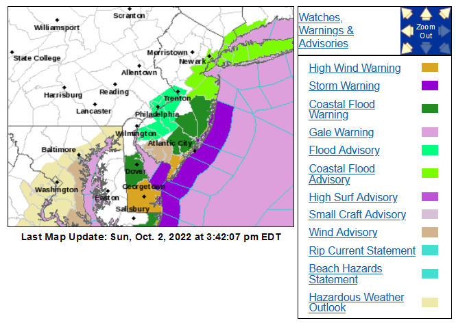
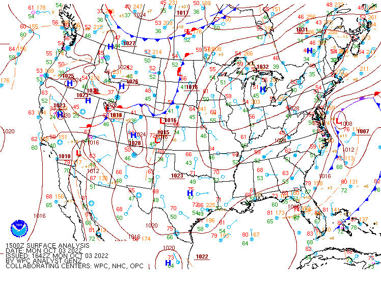
The city was briefly under a flood advisory in the mid afternoon of Sunday (Oct. 2, 2022). There was also an underlay of a coastal flood advisory for the metro area. I wasn't out in any of it but I registered 1.95" of rain just for that day, the most for a daily total out of the 6 days that we got some kind of precipitation. Where I live with a number of hills, I know there are a couple low lying areas near the little feeder creeks that feed the Wissahickon Creek that probably generated some minor street flooding. One such stretch was literally closed for months a year ago as part of a planned project to improve the drainage issues from rain runoff. Never got chance to see if the improvements worked or not.
-
Received no more measurable yesterday after my last report so my final tall was 5.02" for what became a 6-day event (with 5 of those days being in October). My low this morning was 51 and for the first time in a week, the sun has appeared. It's currently mostly sunny and 54 with dp 50.
-
From the Washington Post yesterday - https://www.washingtonpost.com/nation/2022/10/05/hurricane-ian-florida-victims/
-
Saw there were a couple rainfall RERs for MPO and ABE for yesterday (no record low maxes though) - Skies here were finally trying to clear but not fast enough to do so before sunset. Still mostly cloudy and hanging in there at 60 with dp 59.
-
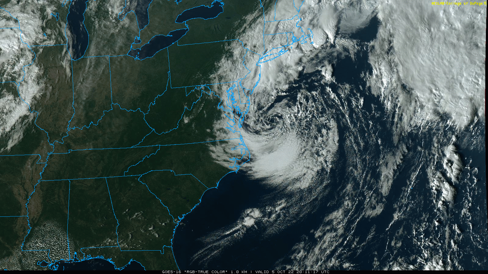
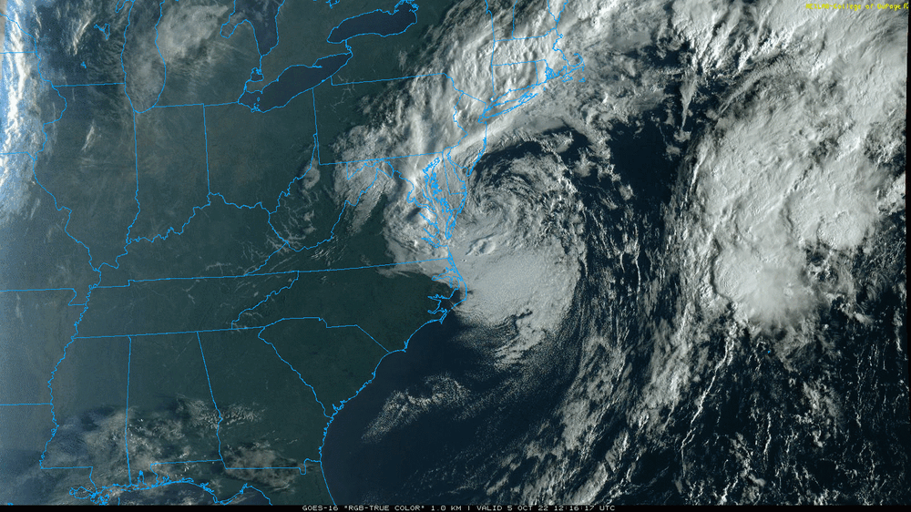
Well the doppler has thinned out considerably although when I popped by the supermarket earlier this morning, a thin band decided to set up over my area and I got some measurable stratiform-like rain. So that brought me to 0.05" so far today and tipped me over the 5" mark at 5.02" since last Friday. After the damp, wet chill of the 40s yesterday, today's continued temp rise was distinctively humid. It's currently overcast and 60 (so far my high for the day) after a low of 51 earlier this morning, and with a dp of 58. Zombie Ian is still sitting out there spinning although some of the bands are getting more and more sparse.

- 852 replies
-
- 1
-

-
- hurricane
- tropical storm
- (and 1 more)
-
Looks pretty impressive and more organized on the sat this morning! Temp in IMBY has crept up to 55 with dp 55 and it's overcast and misty.
- 852 replies
-
- 1
-
-
- hurricane
- tropical storm
- (and 1 more)
-
Eventually picked up a total of 0.69" of rain yesterday and along with another 0.02" so far this morning, that brings me to a total of 4.99" since last Friday. Low yesterday was 45 and I reached a high of 51. There has been some non-diurnal warming overnight so it's currently 54 and misty, with dp 53.
- 852 replies
-
- 1
-
-
- hurricane
- tropical storm
- (and 1 more)
-
Yeah I finally saw something in today's AFD about potential record low max (I usually look at the 4 am and 4 pm - or thereabouts - ones each day and that wasn't in there until late last night and then through the day today - meant to scroll all the way down to check earlier this morning). I also saw mention of an RER for PHL for Oct. 2 rain and for ACY/AC Marina for Oct. 3 rain - Meanwhile I'm now up to 0.64" for the day (4.92" since last Friday). Currently in another lull and it's a misty 50 with dp 49.
-
Looks like I am in a lull so the tally for the day so far is at 0.60", bringing me to 4.88" for the event (since last Friday). Currently damp and misty and 48, with dp 47. I did finally break down and put the heat on this morning.
-
I'm wondering what our record low max is - have been trying to dig around for it. If this setup had occurred in February, we would have been buried. It would have been "Tug Hill Plateau South" territory. Ironically 3 years ago around this time, Philly hit 95 (Oct. 2) - https://www.inquirer.com/weather/philadelphia-weather-record-heat-autumn-rain-20191002.html It's currently misty and 45 with dp 44. I finished up with 0.69" of rain yesterday and with the 0.24" that I have received since midnight, I am now at 4.52" for the event (since last Friday). Doing a 10:1 ratio on that is scary.
- 852 replies
-
- 1
-
-
- hurricane
- tropical storm
- (and 1 more)
-
I saw a video compilation of the 'cane that was tweeted out and you can see when the ERC happened (fairly quickly too) and the eye dilated like a ****.
-
Running rain tally for today after some on and off showers ,is 0.64" (4.23" for the event). My "high" was 49 today, the last time having that high (or at least close at a 50) was back on April 18 & 19. Currently misty and 46 with dp 44.
-
I've been looking at that firehose since yesterday. I know it has to be tearing up the beaches.

- 852 replies
-
- 2
-
-
- hurricane
- tropical storm
- (and 1 more)
-
By the way, meant to mention to you and Birds that I normally monitor the Live Storm Chasing guys and have seen more and more freelancers on that including one who was going all weekend who I discovered was running on there out of Ryan Hall Ya'll's outfit (Brandon Copic)! OMG. That guy's a nut but I like the chatty ones anyway. Also meant to mention that I think you brought up the Fujiwara ballroom dance going on with what was left with Ian earlier. I was thinking it would do a completely transfer but all it seemed to do was step out onto the dance floor and took a partner. Am now up to 0.54" for the day, 4.13" for the event and it's currently 48 and misty with dp 46.
-
Running rain tally for the day so far has me just ticking over to 0.50" this morning for a 4-day event total of 4.09" at post time. My low this morning has so far been 44 and it's currently lightly raining and 46 with dp 44.
-
I watched chasers who were down there during landfall and the one thing that chasers with their dashcams do show, is what the neighborhoods look like, as they go down various streets. The one significant thing that I noticed with where Ian hit was that in certain locales like Punta Gorda and Port Charlotte you had more "Charley-standard" construction where in other locations like Ft. Meyers Beach and Cape Coral, you basically had mobile home parks and 1 or 2-story wood construction units. Those were just inundated, with some that literally exploded from the winds and/or were washed off their foundations. There were a number of pics of clusters of tumbled-over and bunched mobile homes and trailers that were surrounded by and jumbled up with boats that had washed onshore and slammed against them. And making it worse was that you have a huge river that cuts through Ft. Meyers that just added to the inundation. And distinctively, if comparing to what happened with Michael land-falling @ Mexico Beach/Port St. Joe, where most if not all of those homes obliterated on those beaches were either luxury condos/vacation homes and/or tourist rentals, the homes in the Ft. Meyers area were actual year-round residential, many including working class support staff for the resorts and tourism in the area. https://www.usatoday.com/story/news/2022/10/01/hurricane-ian-fort-myers-mobile-home-residents/8141577001/ These mobile parks and little residential streets may be where the heartbreak happens.
-
Finished up with 1.95" of rain Sunday and currently have 0.18" this morning for a total of 3.77" for the 4-day event. And sh*t - just looked at my temp and I'm at 44 with dp 42. I have a couple potted tropical plants still out that won't like that. I usually start bringing in the more temperature sensitive ones about mid-October as they don't like lows (consistently) below the mid-50s, which we hadn't yet reached yet. My subtropical ones should be fine and I usually start getting those ready by the end of October.
- 852 replies
-
- 1
-
-
- hurricane
- tropical storm
- (and 1 more)
-
Have 1.80" in the bucket for the day so far at post time (3.44" for the 3-day event). In another pause in the rain but it is still misty and 51 with dp 50.
-
Now up to 1.39" for the day (3.03" for the 3-day event so far). There was a pause for a bit but the rain has picked up again. Currently 51 with dp 50 and light rain.
-
And that looks to sit there for awhile too. Now have 1.28" for the day (2.92" for the 3 days). I did see a Flood Advisory was issued for Philly metro. KYW traffic was reporting that both the Black and White Horse Pikes are closed for flooding outside of AC.
- 852 replies
-
- 1
-
-
- hurricane
- tropical storm
- (and 1 more)
-
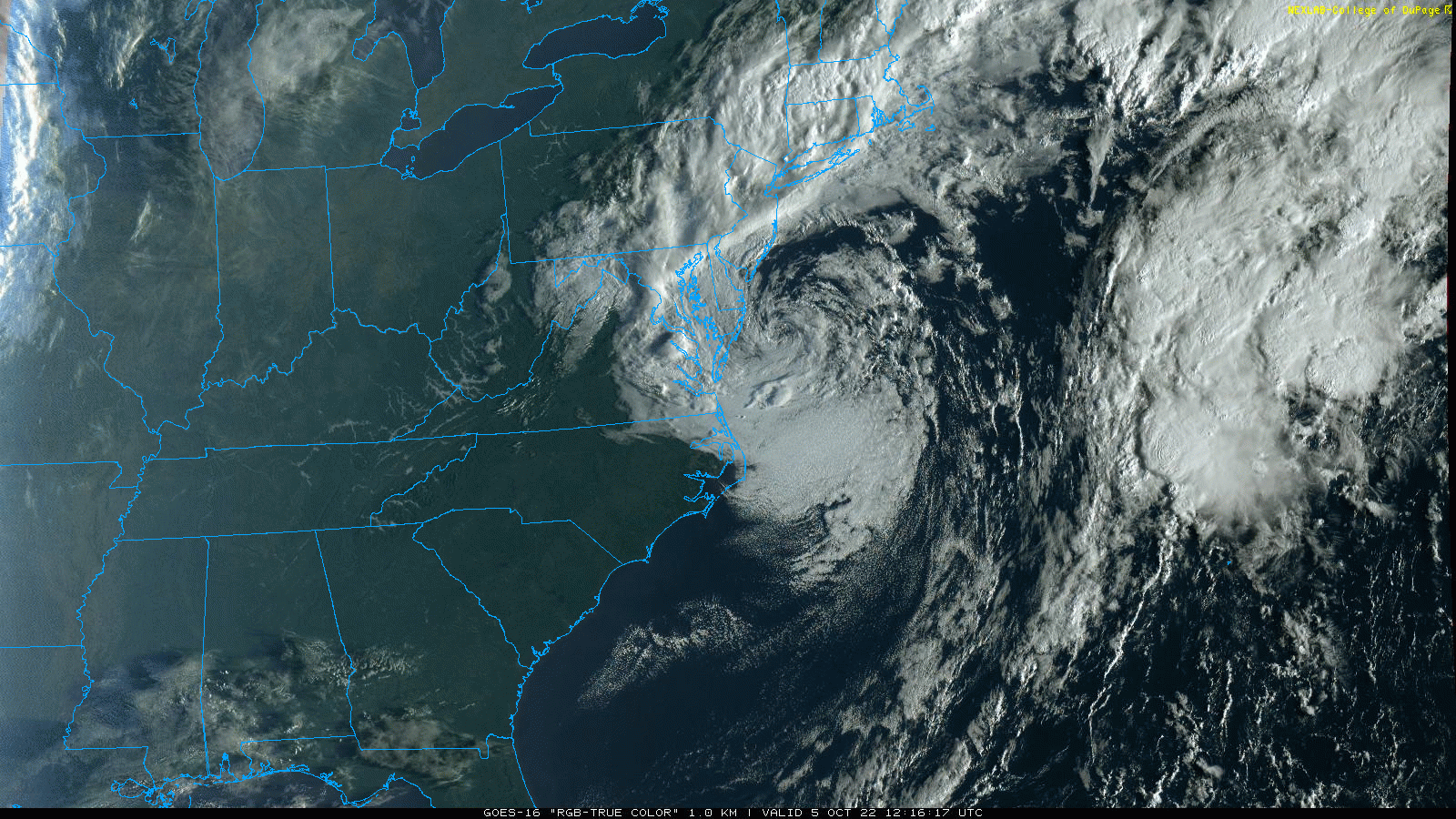
Looks like Ian has transferred to the offshore low and that low is sitting not far from the 40/70 benchmark. LOL
- 852 replies
-
- 1
-
-
- hurricane
- tropical storm
- (and 1 more)
-
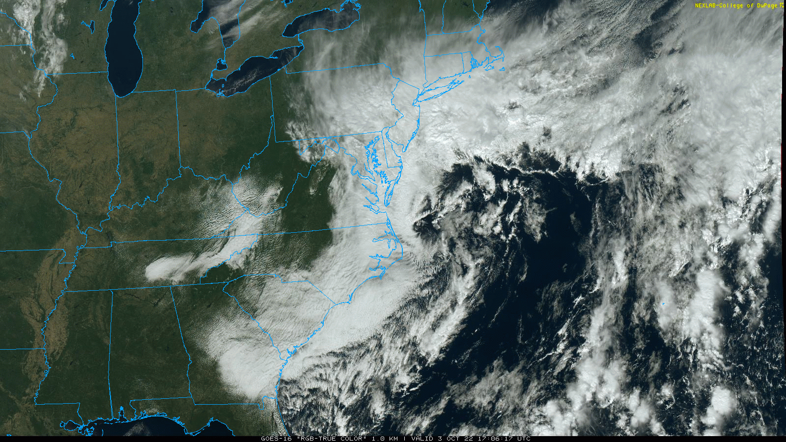
Wow. Mother Nature produces a forecast fail that had originally progged this area for 1 - 1.5" or so, and we are easily double that total over the past couple days. Just for today, am up to 1.12" at post time and with the 1.62" yesterday and 0.02" Friday night, I am at 2.76" for the 3 days so far and am way WEST of I-95, where S/E was supposed to have "more". Currently have light rain and 53 with dp 52.
- 852 replies
-
- 2
-
-
- hurricane
- tropical storm
- (and 1 more)
-
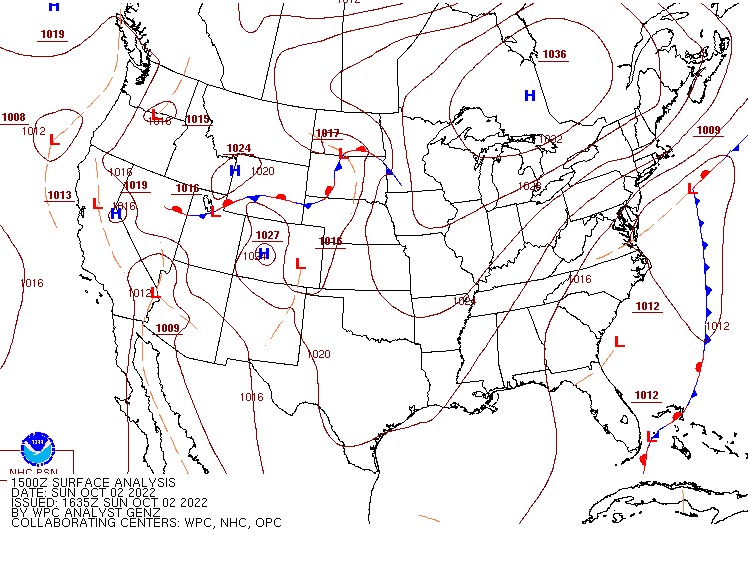
Looks like Ian is gonna do a dress rehearsal of a "Miller B-style" transfer to the coast and then become a cut off nor'easter. Finally finished up with 1.62" of rain before the midnight bell and have picked up another 0.03" this morning, so am now at 1.67" total over 3 days. Also noted the low stratus and some fog before I headed off to bed last night. The low so far this morning has been 56 and it's currently overcast, misty, and 57 with dp 51.
-
Another small band passed through here between 9 - 10 am giving me another 0.04" for 1.59" for the day (so far) and 1.61" for the 2-day event. Currently overcast/misty and 55 with dp 55.
-
For the winter lovers, I did see this posted in the Ian thread (including the newer tweets - the report came from someone up in the mountains) - Also saw this -
- 852 replies
-
- 2
-
-
- hurricane
- tropical storm
- (and 1 more)