Hurricane Agnes
-
Posts
9,344 -
Joined
Content Type
Profiles
Blogs
Forums
American Weather
Media Demo
Store
Gallery
Everything posted by Hurricane Agnes
-
E PA/NJ/DE Summer 2022 OBS Thread
Hurricane Agnes replied to Maxwell03's topic in Philadelphia Region
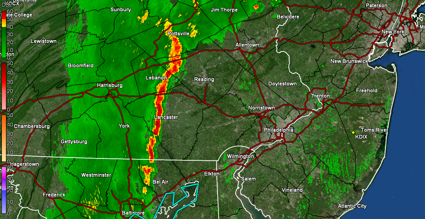
Met summer stats - JUN - 4.46" rain / 90+ days = 3 JUL - 1.65" rain / 90+ days = 14 AUG - 3.57" rain / 90+ days = 14 Hottest day was a 98 on 7/24/22. Had 3, 90+ days in May as an ancillary piece of data. Looks like we may get through August with a rare event of not having some named TS in the Atlantic during the month of August. -
E PA/NJ/DE Summer 2022 OBS Thread
Hurricane Agnes replied to Maxwell03's topic in Philadelphia Region
Well just heard on KYW that PA went on and and issued a Drought Watch for 36 counties - https://www.ahs.dep.pa.gov/NewsRoomPublic/articleviewer.aspx?id=22185&typeid=1 Federal Federal drought monitor - Otherwise, big difference between yesterday and today. I did make it to 84 as a high but the dews finally had a significant drop. Currently partly sunny and 83 with dp 57. -
E PA/NJ/DE Summer 2022 OBS Thread
Hurricane Agnes replied to Maxwell03's topic in Philadelphia Region
Final high yesterday was 91 and my low at the moment, is 68. Final rain for yesterday was 0.14", with 3.57" for the month (most of that happening in one storm on 8/22/22). Currently mostly sunny and 69 with dp 66. -
E PA/NJ/DE Summer 2022 OBS Thread
Hurricane Agnes replied to Maxwell03's topic in Philadelphia Region
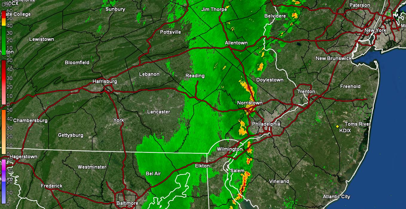
Pretty much done now and down to mist. Final for that batch was 0.14" as a moderate shower that the plants will appreciate (since I gave most of them a light drink a couple days ago). Currently clearing and 73 with dp 71. -
E PA/NJ/DE Summer 2022 OBS Thread
Hurricane Agnes replied to Maxwell03's topic in Philadelphia Region
Can see the breaks in the clouds and the sunset happening off to the west. Currently at 0.14". -
E PA/NJ/DE Summer 2022 OBS Thread
Hurricane Agnes replied to Maxwell03's topic in Philadelphia Region
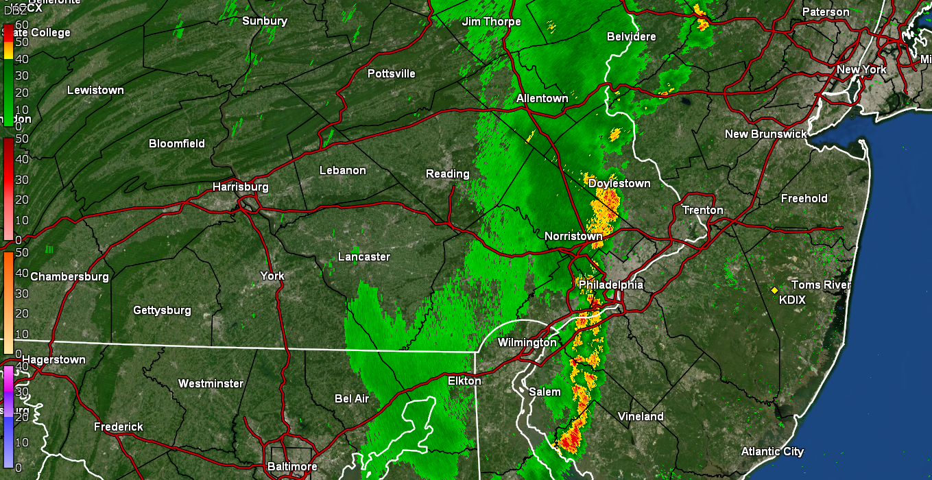
Under a nice heavier 0.5"/hr shower. Currently up to 0.11" with temp 74 and dp 72. -
E PA/NJ/DE Summer 2022 OBS Thread
Hurricane Agnes replied to Maxwell03's topic in Philadelphia Region
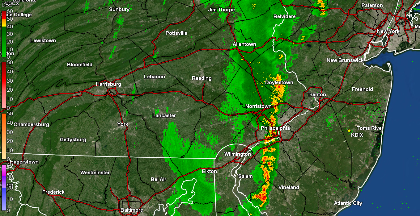
Finally getting some rain. Line is reforming right over the city. Currently at 0.04". Temp down to 76 with dp 72.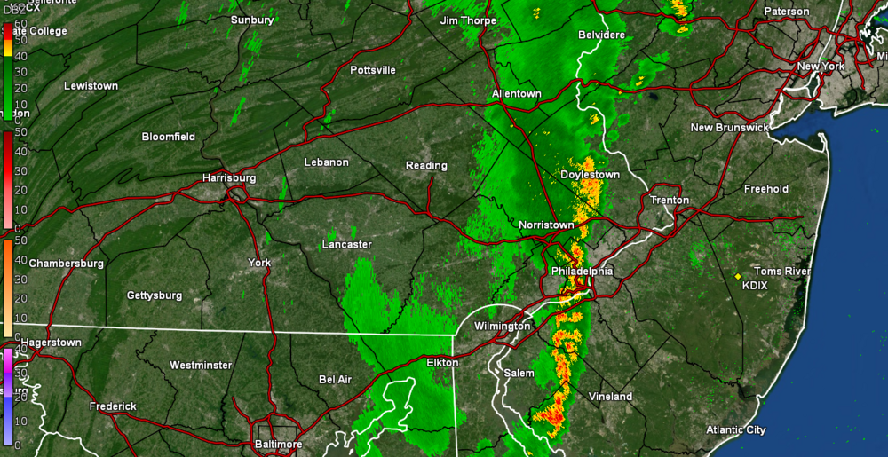
-
E PA/NJ/DE Summer 2022 OBS Thread
Hurricane Agnes replied to Maxwell03's topic in Philadelphia Region
The gust front sortof limped through and is opening up a hole over NW Philly. It has dropped the temp down a bit - to 80 with dp 71.
-
E PA/NJ/DE Summer 2022 OBS Thread
Hurricane Agnes replied to Maxwell03's topic in Philadelphia Region
Can see the gust front incoming. It has been getting progressively darker in any case. Also getting some convection per the lightning detector. Currently overcast and 85 with dp 73.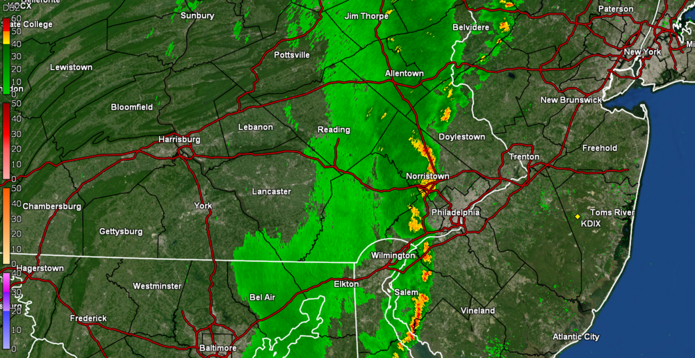
-
E PA/NJ/DE Summer 2022 OBS Thread
Hurricane Agnes replied to Maxwell03's topic in Philadelphia Region
Wow. That band to the west consolidated into a line. Will see if it holds together. Currently 89 with dp 73 and partly sunny.
-
E PA/NJ/DE Summer 2022 OBS Thread
Hurricane Agnes replied to Maxwell03's topic in Philadelphia Region
Have now reached 90+ #14 for August (#34 since May) with a high so far of 91. Currently mostly sunny and 90 with dp 73. -
E PA/NJ/DE Summer 2022 OBS Thread
Hurricane Agnes replied to Maxwell03's topic in Philadelphia Region
SPC SWDY1 outlook has the central and western parts of the CWA in a "Marginal Risk" for severe - We shall see... Meanwhile temp has climbed to 86 here with dp 75, with scattered cumulus. -
E PA/NJ/DE Summer 2022 OBS Thread
Hurricane Agnes replied to Maxwell03's topic in Philadelphia Region
I bottomed out at a warm 75 this morning, with no fog but with steamy windows and some low stratus again that quickly dissipated. It's currently unsettled, with clouds rolling in and out to intermittently block the sun, and 77, with dp an ugly 74. -
E PA/NJ/DE Summer 2022 OBS Thread
Hurricane Agnes replied to Maxwell03's topic in Philadelphia Region
Managed to just barely tap 90 about 3:15 pm today (90+ day #13 for August & #33 since May). The humidity was definitely back and it's currently mostly sunny and 89 with dp 70. -
E PA/NJ/DE Summer 2022 OBS Thread
Hurricane Agnes replied to Maxwell03's topic in Philadelphia Region
Actually didn't get the fog here this morning but had plenty of steamy windows and low stratus, with sun breaking through on occasion. Bottomed out at 71 and it's currently mostly cloudy and 74, dp 74. -
E PA/NJ/DE Summer 2022 OBS Thread
Hurricane Agnes replied to Maxwell03's topic in Philadelphia Region
Congrats. It's literally like rolling the dice to get under a cell. The rain from the one that I got under last week gave me a good dousing although for some of the plants I have that prefer moist conditions, I'll have to give them some more probably tomorrow as I doubt that I'll get under anything with this current hit or miss setup. -
E PA/NJ/DE Summer 2022 OBS Thread
Hurricane Agnes replied to Maxwell03's topic in Philadelphia Region
WOW. LOL Well with the clouds coming and going all day, the temps stayed below 90 and I managed an 86 for a high. I saw the pop-ups in S. Jersey and the resulting boundaries from those got close but washed out before getting here, although there was a brief period of a threat that quickly dissipated. Currently 81 and partly sunny with dp 72. -
E PA/NJ/DE Summer 2022 OBS Thread
Hurricane Agnes replied to Maxwell03's topic in Philadelphia Region
I found this part of the article that was interesting - Which just goes to show that old mets don't go off into the sunset but can pop-up like a convective cell in Emergency Management! -
E PA/NJ/DE Summer 2022 OBS Thread
Hurricane Agnes replied to Maxwell03's topic in Philadelphia Region
Bottomed out at 73 this morning with no fog but lots of stratus,. The skies have been changeable this morning, with the sun occasionally breaking through and then disappearing. The big difference today has been the humidity, Currently overcast and 77 with dp 72. -
E PA/NJ/DE Summer 2022 OBS Thread
Hurricane Agnes replied to Maxwell03's topic in Philadelphia Region
Like everyone else here N/W of PHL, the clouds rolled in and hung around for most of the afternoon, keeping the 90 away IMBY but got close. Made it to 89, although the clouds did start to break up some in the past hour but I think we are pretty much past peak heating at this point. Currently partly sunny and 87 with dp 65. -
E PA/NJ/DE Summer 2022 OBS Thread
Hurricane Agnes replied to Maxwell03's topic in Philadelphia Region
Had a 72 low this morning and some steamy windows. Currently on the way up and 75 with dp 68. -
E PA/NJ/DE Summer 2022 OBS Thread
Hurricane Agnes replied to Maxwell03's topic in Philadelphia Region
I managed to hit 91 again today for 90+ day #12 for August (#32 since May). Currently partly sunny and 89 and the dews mixed out a bit and are "down to" 67. -
E PA/NJ/DE Summer 2022 OBS Thread
Hurricane Agnes replied to Maxwell03's topic in Philadelphia Region
My final high for yesterday was 91 and my "low" (in quotes) was 72 this morning. So started out with a steamy window morning. It touched 87 earlier but the sky has filled up with cumulus, basically blocking the sun, so it's currently 86 with a very noticeable dp of 72. I could feel the near sauna out there this morning when i went out to run some errands. -
E PA/NJ/DE Summer 2022 OBS Thread
Hurricane Agnes replied to Maxwell03's topic in Philadelphia Region
My low this morning was 68 and I made it up to 91 as a high so far today (90+ day #11 for August, #31 since May) but huge difference having the dp in the low 60s. Currently partly sunny and 88 with dp 60. -
E PA/NJ/DE Summer 2022 OBS Thread
Hurricane Agnes replied to Maxwell03's topic in Philadelphia Region
Didn't reach 90 today but made it to 88. Humidity was lower than yesterday which was a bonus. Currently 78 and clear with dp 63.