Hurricane Agnes
-
Posts
9,344 -
Joined
Content Type
Profiles
Blogs
Forums
American Weather
Media Demo
Store
Gallery
Everything posted by Hurricane Agnes
-
E PA/NJ/DE Summer 2022 OBS Thread
Hurricane Agnes replied to Maxwell03's topic in Philadelphia Region
Miracle of miracles. Some little blob just appeared over me. I had noticed it got a little darker than it was earlier and then looked out and it was raining. Currently have 0.01" and temp is down to 79 with dp 71 but I'll take it.
-
E PA/NJ/DE Summer 2022 OBS Thread
Hurricane Agnes replied to Maxwell03's topic in Philadelphia Region
Had a low of 70 this morning and got as high as 86 so far today, but with changeable skies, the temp has fluctuated quite a bit. It's currently mostly cloudy with occasional breaks of sun and 84 with dp 68. -
E PA/NJ/DE Summer 2022 OBS Thread
Hurricane Agnes replied to Maxwell03's topic in Philadelphia Region
Thanks to a deck of clouds overnight and early this morning, I only dropped to 72 as a low and have already hit 93 today. It's currently 91 (#10 for August, #30 since May), with cumulus rolling in, and dp 64 -
E PA/NJ/DE Summer 2022 OBS Thread
Hurricane Agnes replied to Maxwell03's topic in Philadelphia Region
Ended up with 91 as a high today for 90+ #9 for August (#29 since May). My last 90 was on 8/10/22. The cumulus has slowly been replaced with some cirrus and it's currently partly sunny and 85 with dp up a bit to 65, so it begins.... Watching for the development of odds and ends storms in the Gulf and hoping we can maybe get some remnant moisture shunted up here. -
E PA/NJ/DE Summer 2022 OBS Thread
Hurricane Agnes replied to Maxwell03's topic in Philadelphia Region
I surprisingly hit 90 initially about 10 after noon today and then the rest of the afternoon resulted in an explosion of cumulus and unsettled skies. Since then it's now partly sunny and 91 with dp 62. (humidity of 38% which isn't bad). -
E PA/NJ/DE Summer 2022 OBS Thread
Hurricane Agnes replied to Maxwell03's topic in Philadelphia Region
I dropped to a "warmer" 65 this morning compared to the previous mornings and as progged, the temps are off to the races. I'm currently at 84 and sunny with dp 62. -
E PA/NJ/DE Summer 2022 OBS Thread
Hurricane Agnes replied to Maxwell03's topic in Philadelphia Region
Bottomed out at 62 this morning and could have been cooler but the wind didn't go calm. So far it's turned out to be a nice late summer day and when I went out to the supermarket this morning, I was greeted by a buzzing cicada, just like the "old days" (of last summer). It's currently mostly sunny and 84 with dp 59. -
E PA/NJ/DE Summer 2022 OBS Thread
Hurricane Agnes replied to Maxwell03's topic in Philadelphia Region
Topped out at 82 today, with what became changeable skies this afternoon as the furthest segments of the nor'easter's rain bands expertly skipped over MBY headed south and west. It's currently mostly cloudy with occasional breaks in the clouds to reveal some sun, and 78, with dp 56. -
E PA/NJ/DE Summer 2022 OBS Thread
Hurricane Agnes replied to Maxwell03's topic in Philadelphia Region
La Nina 3-peat progged for winter apparently (would only be the 3rd time on record for that circumstance)- https://www.climate.gov/news-features/blogs/august-2022-enso-update-summer-nights Last year, my last 90+ (a 93) was on 8/27/21 and a last 90+ the year before (a 92) was on 8/27/2020. Bottomed out at 63 this morning as the winds went almost calm but the temp has quickly recovered and it's currently 70 with dp 63. -
E PA/NJ/DE Summer 2022 OBS Thread
Hurricane Agnes replied to Maxwell03's topic in Philadelphia Region
I've had 0.95" for the month here so far, and that was a total from 3 days for the month, with one of those days only netting 0.01". I did make it up to 82 and it's currently partly sunny and 79 with dp 59, so overall another nice late summer day that's not a blast furnace or sauna. -
E PA/NJ/DE Summer 2022 OBS Thread
Hurricane Agnes replied to Maxwell03's topic in Philadelphia Region
Had a low of 61 this morning as the breeze dropped off although didn't go to calm completely. As the day broke, the breeze has commenced with a northerly component, increasingly out of the NE to reflect that nor'easter off the coast. It's currently partly sunny and 79 with dp a comfortable 56. -
E PA/NJ/DE Summer 2022 OBS Thread
Hurricane Agnes replied to Maxwell03's topic in Philadelphia Region
As expected, it all disintegrated on the way here as subsidence won out as progged. With the sun in and out much of the day, I still managed to reach a high of 83 at about 2:45 pm. It's currently clear with a few scattered clouds here and there towards the west, and 73 with dp 54. -
E PA/NJ/DE Summer 2022 OBS Thread
Hurricane Agnes replied to Maxwell03's topic in Philadelphia Region
Had a low of 63 earlier this morning with overcast, then the sun briefly popped out for a bit sending the temp up to 73, promptly self-destructed, and am down to 69 and overcast again. The stuff out to the west is hitting that dry air right over the city but it's moistening up a bit. Dp is 61. -
E PA/NJ/DE Summer 2022 OBS Thread
Hurricane Agnes replied to Maxwell03's topic in Philadelphia Region
Ended up with a warmer high today when compared to yesterday, hitting 85. It's currently mostly sunny and 81 with dp 54. -
E PA/NJ/DE Summer 2022 OBS Thread
Hurricane Agnes replied to Maxwell03's topic in Philadelphia Region
Ended up with a high of 82 yesterday and a low this morning of 63. The dews yesterday had dropped into the upper 40s but have crept back up today. After a mostly overcast morning that held the temps down, it's currently partly cloudy and 83 with dp 58. -
E PA/NJ/DE Summer 2022 OBS Thread
Hurricane Agnes replied to Maxwell03's topic in Philadelphia Region
Amazing but so far my low this morning was 60, the lowest for just over a month (last one was back on July 11). Finally turned off the AC. It's currently clear and 61 with dp 50. -
E PA/NJ/DE Summer 2022 OBS Thread
Hurricane Agnes replied to Maxwell03's topic in Philadelphia Region
Made it up to 86 as a high today but the big news was the dewpoint drops over 25 degrees lower than the average of the past couple weeks. It's currently 78 at sunset, with a dp of 49. -
E PA/NJ/DE Summer 2022 OBS Thread
Hurricane Agnes replied to Maxwell03's topic in Philadelphia Region
Wasn't sure how low I would go but it wasn't very (although better than the past week). Ended up at 70 and after the stratus cleared and the sun burst out, it's currently 75, with some scattered cirrus and a dp of 61. I did see a Fire Weather section up in the AFD for the next couple days ahead of what is speculated as being a coastal. So hopefully we won't see anything igniting before we get some much-needed rain that supposedly arrives Monday and into next week. -
E PA/NJ/DE Summer 2022 OBS Thread
Hurricane Agnes replied to Maxwell03's topic in Philadelphia Region
Just missed 90 for a high today (made it to 89) and it's currently 80 with dp a much better 61. -
E PA/NJ/DE Summer 2022 OBS Thread
Hurricane Agnes replied to Maxwell03's topic in Philadelphia Region
Dews finally got back below 70 as drier air mixes in. Currently partly sunny (with a mix of cumulus and contrails) and 86 with dp 67. -
E PA/NJ/DE Summer 2022 OBS Thread
Hurricane Agnes replied to Maxwell03's topic in Philadelphia Region
And the sun just popped out briefly as the skies clear. Currently a deck of cirrus overhead with some breaks allowing the sun to pop in and out, and 75 with dp 72. -
E PA/NJ/DE Summer 2022 OBS Thread
Hurricane Agnes replied to Maxwell03's topic in Philadelphia Region
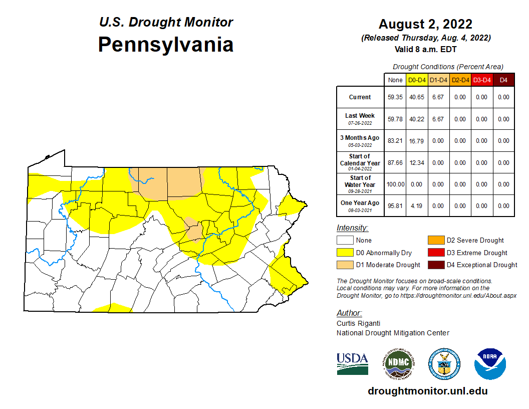
Did a what the hell check and found a PA Drought monitor status published last week (am guessing a new one might issue today). Definitely reflects the issue here in NW Philly as much of the rain and pop-ups have concentrated south of where I am. I know that over th weekend, a "Drought Watch" had been declared and heavily advertised on KYW for Jersey, but we have our issues here on this side of the river. I eeked out another 0.01" and stand at 0.59" at post time, with the heaviest rains now all over NJ. Currently misty and 72 with dp 72.
-
E PA/NJ/DE Summer 2022 OBS Thread
Hurricane Agnes replied to Maxwell03's topic in Philadelphia Region
Congrats! I am happy for my now 0.58". Gives me a few days before a need to water again, and with the temps progged to be lower, that will help too. Was gonna reluctantly pull out the hose today and now can wait. Currently a misty 73 with dp 72. -
E PA/NJ/DE Summer 2022 OBS Thread
Hurricane Agnes replied to Maxwell03's topic in Philadelphia Region
Miracle of miracles - leave the patio umbrella up and get 0.44 of rain when I first checked this morning. Popped out quickly and put it down so the rain can hit stuff that was just under the umbrella's canopy. Currently 72 with light rain and dp 72, and so far am up to 0.50" in the bucket.
-
E PA/NJ/DE Summer 2022 OBS Thread
Hurricane Agnes replied to Maxwell03's topic in Philadelphia Region
I managed to just eek out one more 90 today just before 1:30 pm, to add to the tally - #8 for August (#28 since May). It was a bit more unsettled this afternoon with some stratocumulus that kept the sun obscured much of the time and holding the temps down. Otherwise there's nothing really on the radio that suggests the "r" word. It's currently mostly cloudy, with breaks of sun, and 87 with dp 72.