Hurricane Agnes
-
Posts
9,344 -
Joined
Content Type
Profiles
Blogs
Forums
American Weather
Media Demo
Store
Gallery
Everything posted by Hurricane Agnes
-
E PA/NJ/DE Summer 2022 OBS Thread
Hurricane Agnes replied to Maxwell03's topic in Philadelphia Region
I am *finally* getting enough to tip the bucket. The splats on the kitchen window are new. Currently have 0.02" to wet the leaves so I guess I shouldn't be choosy. That will probably be it since it looks like a precip. hole has opened up. Currently 77 with dp 73.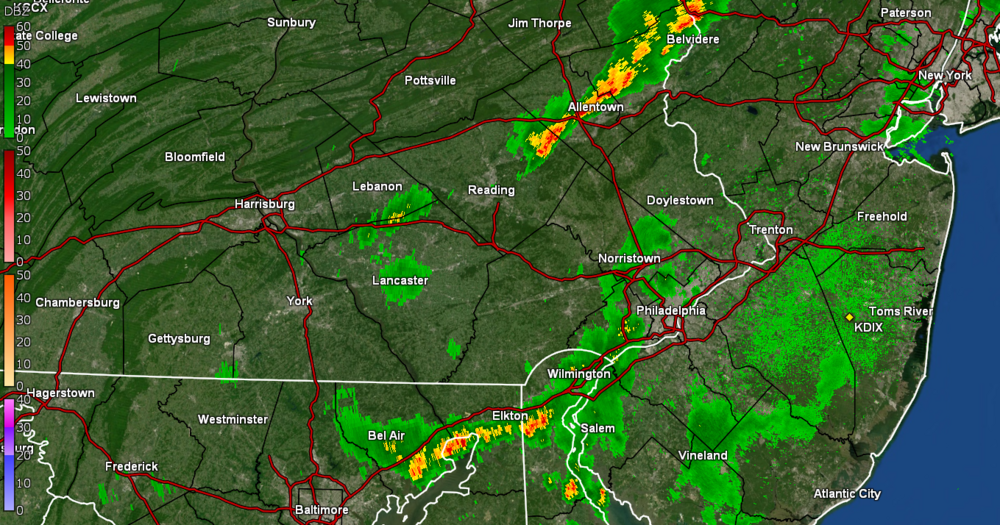
-
E PA/NJ/DE Summer 2022 OBS Thread
Hurricane Agnes replied to Maxwell03's topic in Philadelphia Region
Literally zippo so far today and I won't even bother hoping for that latest batch on the radar. The sun came out bright and strong before sunset. Have a whopping total of 0.47" for the month of July so far and that was from scattered sprinkles each totaling less than 1/4". Currently mostly cloudy again, with a few breaks that I can see, and 79 with dp 74.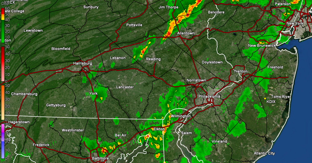
-
E PA/NJ/DE Summer 2022 OBS Thread
Hurricane Agnes replied to Maxwell03's topic in Philadelphia Region
Dammit. Am even picking up convection all around (and had a clap of thunder a couple minutes ago) and the cell is literally like a couple miles to my NW. Sun is trying to break out to the west and south and still haven't tipped the bucket. Temp is "down to" 82 but dp is still 77.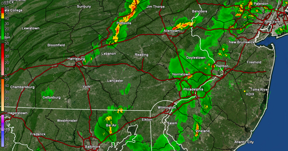
-
E PA/NJ/DE Summer 2022 OBS Thread
Hurricane Agnes replied to Maxwell03's topic in Philadelphia Region
My walk is finally "wettish" but it's STILL not enough to tip the bucket. Temp is 83 with dp 77. There's a little cell to the SW where it would be nice if it did a little dump but I know it will either side-swipe me or fizzle.
-
E PA/NJ/DE Summer 2022 OBS Thread
Hurricane Agnes replied to Maxwell03's topic in Philadelphia Region
I have a cousin who lives in W. Orange, NJ who texted that they were getting torrential downpours, followed by sun, followed by more torrential downpours. Wash. Rinse. Repeat. Meanwhile I am watching the radar just evaporate as it passes over northern Delco and bypasses NW Philly. It's currently 87 with dp 75, an a sky filled with useless clouds (although they are keeping the temps out of the 90s now). -
E PA/NJ/DE Summer 2022 OBS Thread
Hurricane Agnes replied to Maxwell03's topic in Philadelphia Region
So far I have hit a high of 91 today (#6 for July and #11 since May) and stuff keeps fizzling as it approaches MBY. There's a diffuse and small strung-out area to my SW that is just sitting there producing some clouds that I can see looking in that direction but doing nothing else here. Currently cloudy and 89 with dp 76. -
E PA/NJ/DE Summer 2022 OBS Thread
Hurricane Agnes replied to Maxwell03's topic in Philadelphia Region
Norman up with the Watches - Currently variable sun and clouds and 91 with dp that horrible 77. -
E PA/NJ/DE Summer 2022 OBS Thread
Hurricane Agnes replied to Maxwell03's topic in Philadelphia Region
Have now tapped 90 so far with that still unrelenting dp hanging in the upper 70s and currently at 77. There is a little breeze going to try to mix up the air however it can. -
E PA/NJ/DE Summer 2022 OBS Thread
Hurricane Agnes replied to Maxwell03's topic in Philadelphia Region
Well the stratus lifted leaving behind some hazy cumulus and briefly spiked the temp to 88. It's currently a partly sunny and hazy 87 with dp an obscene 78! -
E PA/NJ/DE Summer 2022 OBS Thread
Hurricane Agnes replied to Maxwell03's topic in Philadelphia Region
Had to throw some water on the container plants and still have the low stratus, so at least that is keeping the blaze down. Currently overcast with occasional breaks of sun, and 80 with dp a "Nawleens-like" 76. -
E PA/NJ/DE Summer 2022 OBS Thread
Hurricane Agnes replied to Maxwell03's topic in Philadelphia Region
Ugh. Went to bed hoping to get fringed or side-swiped and NADA. Woke up to steamy windows and a low of 75 earlier. Am watching the bands funneling along a path to the northeast of the area. Apparently the warm front is sitting directly over the city and is serving as a giant canopy that keeps the rain cascading on either side with nothing underneath. It's currently 77 and overcast, with a steamy dp of 74. SPC SWDY1 has the CWA under a "Marginal Risk" for severe but we seem to be in a "dry begets dry" in some parts (like MBY). -
E PA/NJ/DE Summer 2022 OBS Thread
Hurricane Agnes replied to Maxwell03's topic in Philadelphia Region
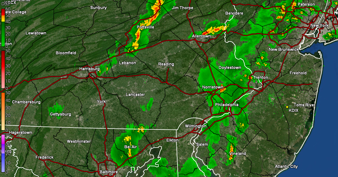
Well Mother Nature felt sorry for me and gave me 0.03" just before midnight and 0.05" between midnight and 2 am for a total of 0.08" for the 2-day event (so far). It was enough to at least wet the leaves. I had done a snapshot of the radar before I had headed off to bed (below) with the hope that enough of that would hold together to graze me. It's currently a steamy-windows morning with some low stratus starting to erode and 70 (after a low so far of 69) and with dp 69.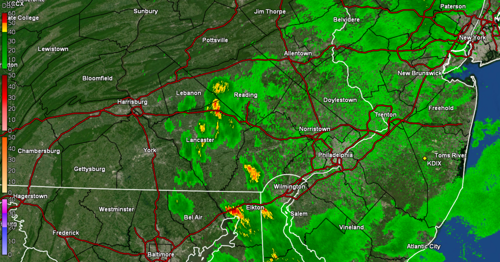
-
E PA/NJ/DE Summer 2022 OBS Thread
Hurricane Agnes replied to Maxwell03's topic in Philadelphia Region
I hope I get something. Last measurable here was July 7 with 0.24". I've only had 0.38" for the month of July to date. Currently 75 with dp 70. -
E PA/NJ/DE Summer 2022 OBS Thread
Hurricane Agnes replied to Maxwell03's topic in Philadelphia Region
Nada here. The radar returns are literally just evaporating away as they approach the city line. It's currently 77 and overcast with dp 71. -
E PA/NJ/DE Summer 2022 OBS Thread
Hurricane Agnes replied to Maxwell03's topic in Philadelphia Region
The walk has dried up and it's like the city is steaming away the rain. Temp is down to 79 and dp is down to 70. All I can do, if nothing can break out of these clouds, is hope for something Monday night 'cause after that, the furnace gets turned on. -
E PA/NJ/DE Summer 2022 OBS Thread
Hurricane Agnes replied to Maxwell03's topic in Philadelphia Region
I figured that was headed your way since it was obvious it wasn't headed my way (although your blob is already starting to fall apart). Still nothing tipping the bucket yet here. -
E PA/NJ/DE Summer 2022 OBS Thread
Hurricane Agnes replied to Maxwell03's topic in Philadelphia Region
LOL A slightly narrow darker green area is now over me and am getting a series of drops. Some are even splatting on my front storm door but we'll see if any of it tips the bucket. Still 80 but the dp is now 71. -
E PA/NJ/DE Summer 2022 OBS Thread
Hurricane Agnes replied to Maxwell03's topic in Philadelphia Region
You are fortunate! Even with returns over me, I got about 30 drops that I could barely see on the walk and am now in a dead zone of nothing. It's currently overcast and teasing rain but not producing, with the temp at 80 and dp 70.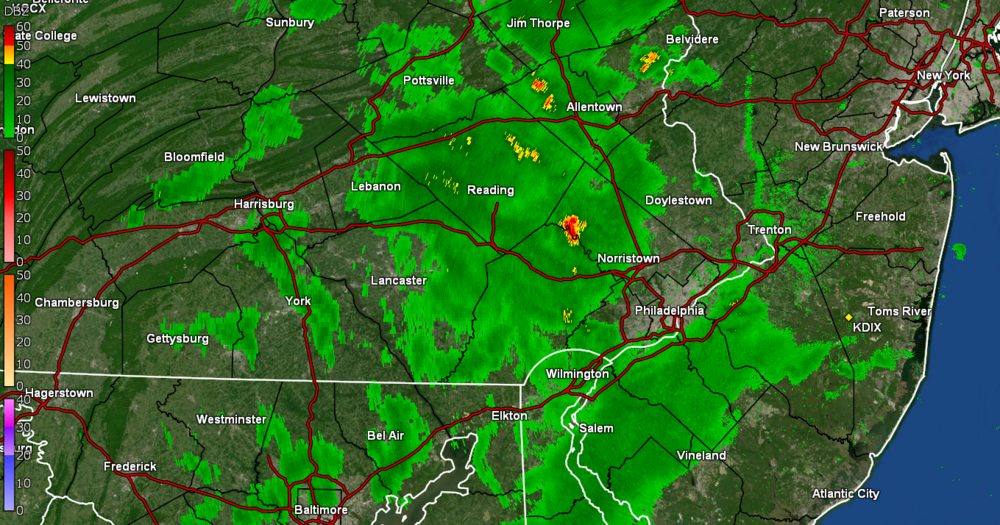
-
E PA/NJ/DE Summer 2022 OBS Thread
Hurricane Agnes replied to Maxwell03's topic in Philadelphia Region
And for the first time this morning, the sun has finally come out! Temp/dp the same as the previous post so far. -
E PA/NJ/DE Summer 2022 OBS Thread
Hurricane Agnes replied to Maxwell03's topic in Philadelphia Region
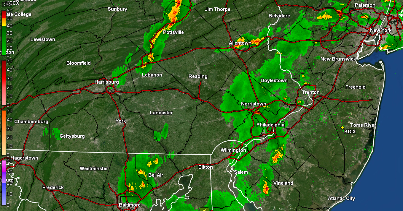
LOL I saw some pop-ups to the west last evening and some of the earlier radar returns managed to wet my sidewalk but nothing measurable. The advancing pop-up (included below) had apparently dissipated upon arrival here and although again, nothing measurable and probably some to wet the leaves and walks. In any case, had a high of 88 yesterday and a low of 69 this morning with quite a bit of overcast so far. It's currently 75 with dp 71.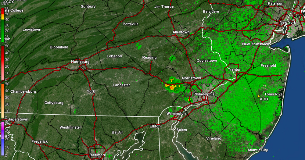
-
E PA/NJ/DE Summer 2022 OBS Thread
Hurricane Agnes replied to Maxwell03's topic in Philadelphia Region
I think all that rain we had in April and May (I recorded over 7" each of those months) plus the persistent trough-over-the-east definitely impacted any persistent heat here. Meanwhile around the rest of the world (including Europe that is apparently reaching or breaking 300 year old heat records) has been under the furnace. It doesn't appear that I'll hit 90 today though, but we'll see. Am currently bopping between 87/88 with dp 63. I had one of those gigantic Chinese Mantises lounging on a milkweed I had last year and it eventually started hanging around my hummingbird feeder (on the fence overlooking it). Had to knock the thing away from that a few times last summer. Example of how they snag them (those suckers can get to be 4" or more long) - -
E PA/NJ/DE Summer 2022 OBS Thread
Hurricane Agnes replied to Maxwell03's topic in Philadelphia Region
I have at least 3 cicada killers out front battling it out for territory. My Upper Darby sis mentioned all the efforts she went through this month to get the ones she has (apparently they need more than regular wasp killer spray to get rid of). I ended up hitting 91 yesterday (the first 3-consecutive-days of 90+ for a heatwave, the 5th 90 of July, and 10th since May) after a low of 73. This morning's low was a slightly cooler 70 and am currently bopping between 86 and 86 with dp 62 and lots of cumulus. -
E PA/NJ/DE Summer 2022 OBS Thread
Hurricane Agnes replied to Maxwell03's topic in Philadelphia Region
That will be a total foul ball that flies behind the batter and gets nowhere near the field here. I did end up making it to 90 here , after a low of 70. It was the 4th 90 or higher temp this month and the 9th 90+ day IMBY since May. Currently have just a few scattered clouds post-sunset, and it's 80, with dp 66. -
E PA/NJ/DE Summer 2022 OBS Thread
Hurricane Agnes replied to Maxwell03's topic in Philadelphia Region
Am dittoing that, Nice wide line moving east, TOR up in NY, and it just about disintegrates over us. Currently 85 and cloudy with dp 72 (which you would think would make it unstable). Edit - I'm getting some droplets making visible spats on the pavement but so far, not enough to be measurable. -
E PA/NJ/DE Summer 2022 OBS Thread
Hurricane Agnes replied to Maxwell03's topic in Philadelphia Region
Norman's Thunderstorm Watches up for the CWA - Before it started clouding up, I made it up to 91 after a low of 68. It's currently threatening and 86 with dp 72.