Hurricane Agnes
-
Posts
9,344 -
Joined
Content Type
Profiles
Blogs
Forums
American Weather
Media Demo
Store
Gallery
Everything posted by Hurricane Agnes
-
E PA/NJ/DE Summer 2022 OBS Thread
Hurricane Agnes replied to Maxwell03's topic in Philadelphia Region
Ended up pulling out the hose finally and still haven't heard any cicadas but I expect with the upcoming heat, they may finally get going. Made it up to 83 today and the dp did creep back up into the 60s. But overall, it was a typical summer day, with fair weather cumulus in the afternoon giving way to changeable skies that are currently filled with stratocumulus. Temp is 76 with dp 64. -
E PA/NJ/DE Summer 2022 OBS Thread
Hurricane Agnes replied to Maxwell03's topic in Philadelphia Region
Was out there about 20 minutes ago and didn't hear any but good that they are up and about now! I did see a butterfly (looked like a little Red Admiral) on one of my tall cone flowers that recently started blooming. Gonna have to pull the hose out. The humidity is down although that sun is strong. -
E PA/NJ/DE Summer 2022 OBS Thread
Hurricane Agnes replied to Maxwell03's topic in Philadelphia Region
Finally the drier air started pushing in sometime between ~ 7 am - 8 am and my dp finally dropped into the upper 50s. After a low of 65 this morning, it's currently sunny and 74 with dp 57.
-
E PA/NJ/DE Summer 2022 OBS Thread
Hurricane Agnes replied to Maxwell03's topic in Philadelphia Region
It would be nice to have more data from the 6z and 18z that we usually laugh at but obsessively look at anyway. -
E PA/NJ/DE Summer 2022 OBS Thread
Hurricane Agnes replied to Maxwell03's topic in Philadelphia Region
RedSky had posted something about a hardware upgrade a few pages back, so if the model update hasn't happened yet, this might make it possible to move forward with it - The linked article does mention the ensembles, which suggests that the hardware upgrade will be a go-ahead for the EPS update - Well the sun managed to come out for about 5 minutes around 6 pm (longest appearance of the day) before it disappeared again. But in any event, I pretty much finished up with the 0.08" for the day. High did make it to 78 and the dp sortof dropped down to the upper 60s vs the lower 70s, and it's currently 74 with dp 67. -
E PA/NJ/DE Summer 2022 OBS Thread
Hurricane Agnes replied to Maxwell03's topic in Philadelphia Region
Talk about stingy! So far what looked promising when I went to bed last night resulted in 0.08", with most of it between 2 - 3 am, and a dribble between 4 - 5 am. Whatever is on the radar now is just sitting in the clouds. After a low of 71, it's currently overcast and 73 with a dp of 66. -
E PA/NJ/DE Summer 2022 OBS Thread
Hurricane Agnes replied to Maxwell03's topic in Philadelphia Region
Damn - I was just looking at the cluster up in your neck of the woods too and said he's GOT to be getting something outta that. But alas. It's still overcast here and 80 with dp 72. -
E PA/NJ/DE Summer 2022 OBS Thread
Hurricane Agnes replied to Maxwell03's topic in Philadelphia Region
After a low of 65 this morning, I did make it up to 86 today, even with mostly sunny skies, but the humidity was pretty rough with dews in the low 70s the entire time. It has clouded up now and is currently 84 with dp 73. Hoping for a quick pop-up or something tonight. Still grateful for the surprise 024" that I got yesterday, -
E PA/NJ/DE Summer 2022 OBS Thread
Hurricane Agnes replied to Maxwell03's topic in Philadelphia Region
Looks like I finished up with 0.24" from the stuff thrown up here from the low traversing the stalled front. Was able to get the plant leaves a bit of a wash after that. Currently overcast, 70 and dp 69, with occasional steamy windows. -
E PA/NJ/DE Summer 2022 OBS Thread
Hurricane Agnes replied to Maxwell03's topic in Philadelphia Region
Grateful for this so far and saw a Flood Advisory lofted for south of I-76 and west of I-95- So far have 0.23" in the bucket and obviously the heavier stuff is to my south but me take. Currently light rain and 69 with dp 68. -
E PA/NJ/DE Summer 2022 OBS Thread
Hurricane Agnes replied to Maxwell03's topic in Philadelphia Region
There are actually droplets falling from the sky - KYW traffic report whining about it and I'm celebrating! It started up here just after 4 am and so far have 0.10" in the bucket. Currently 70 and light rain with dp 69.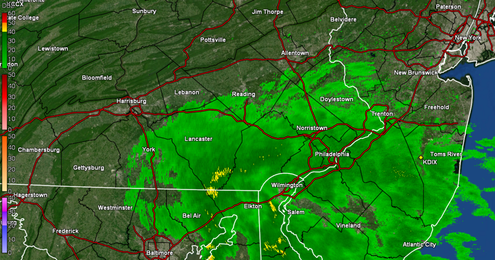
-
E PA/NJ/DE Summer 2022 OBS Thread
Hurricane Agnes replied to Maxwell03's topic in Philadelphia Region
I think if we had had more days of heat last month, they might have emerged sooner. But by having our winter in spring and it being springish in early summer, that probably slowed them down if the ground was still too cool. I am more surprised about the lack of crickets so far. I guess being still early July can be deceptive for expectations. I did make it to 89 as a high while watching strands of pearls tstorm cells blowing past to my south and north despite some periodic threatening clouds. I did manage to get a passing light shower that deposited 0.06" the morning of July 3rd but nothing since June 27, so I guess I'll be grateful for that. The grass here has held so far but don't know how much longer... It's currently 84 and mostly cloudy with some occasional breaks of sun, and dp is 66. -
E PA/NJ/DE Summer 2022 OBS Thread
Hurricane Agnes replied to Maxwell03's topic in Philadelphia Region
Yup. They have a short but intense growing season up yonder (at least in the upper plains). Well not a drop of rain overnight so... Anyway had a "low" of 74 this morning and it's currently 82 (although it earlier spiked to 84) and the dp is 73. -
E PA/NJ/DE Summer 2022 OBS Thread
Hurricane Agnes replied to Maxwell03's topic in Philadelphia Region
Well it has started clouding up and there is stuff on the radar... but whether it survives to get here intact is the $64,000 question. It's currently overcast and 84 (after making it up to 87 before the clouds rolled in) with dp 70. -
E PA/NJ/DE Summer 2022 OBS Thread
Hurricane Agnes replied to Maxwell03's topic in Philadelphia Region
Only thing is - those more northern latitude areas also get longer hours of daylight (e.g., International Falls, MN has just over 16 hours of daylight around the solstice) where around this neck of the woods, we are just barely hitting 15 hours max. So although they may be closer to the Canadian air masses, they have extended heating whenever a ridge builds over that part of the country. Otherwise without an amplified ridge and a more zonal flow, I expect they would definitely be cooler up there - at least if they aren't in a drought state (where that tends to amplify and radiate the heat much more). Well had to get out there and give my plants some top-off water and the humidity is definitely starting to build although it wasn't too bad when in some shade. It's currently 85 and mostly sunny (after a low of 68), with some cirrus and a few cumulus clouds starting to pop up, and with dp 69. -
E PA/NJ/DE Summer 2022 OBS Thread
Hurricane Agnes replied to Maxwell03's topic in Philadelphia Region
Amazing low-humidity day yesterday with a final high of 89 and not a cloud in the sky. Had a great bbq at one of my sister's houses yesterday and the lightning bugs were competing with the early fireworks. After a low of 65 this morning, made it up to 87 today and it's currently 84 and mostly sunny with lots of cirrus and a low dp of 53. -
E PA/NJ/DE Summer 2022 OBS Thread
Hurricane Agnes replied to Maxwell03's topic in Philadelphia Region
The "leftovers" this morning finally gave me some measurable - albeit a measly 0.06" but I guess I'll take it. Bottomed out at 72 this morning with steamy windows but the dp has been dropping, the clouds are parting, and the temp is 75 with dp 63. -
E PA/NJ/DE Summer 2022 OBS Thread
Hurricane Agnes replied to Maxwell03's topic in Philadelphia Region
I got zero here and was hoping for some rain so I don't have to pull out the hose. Am guessing the cold front has sagged south and took the rain with it as the temp has dropped to 77 with dp 68. -
E PA/NJ/DE Summer 2022 OBS Thread
Hurricane Agnes replied to Maxwell03's topic in Philadelphia Region
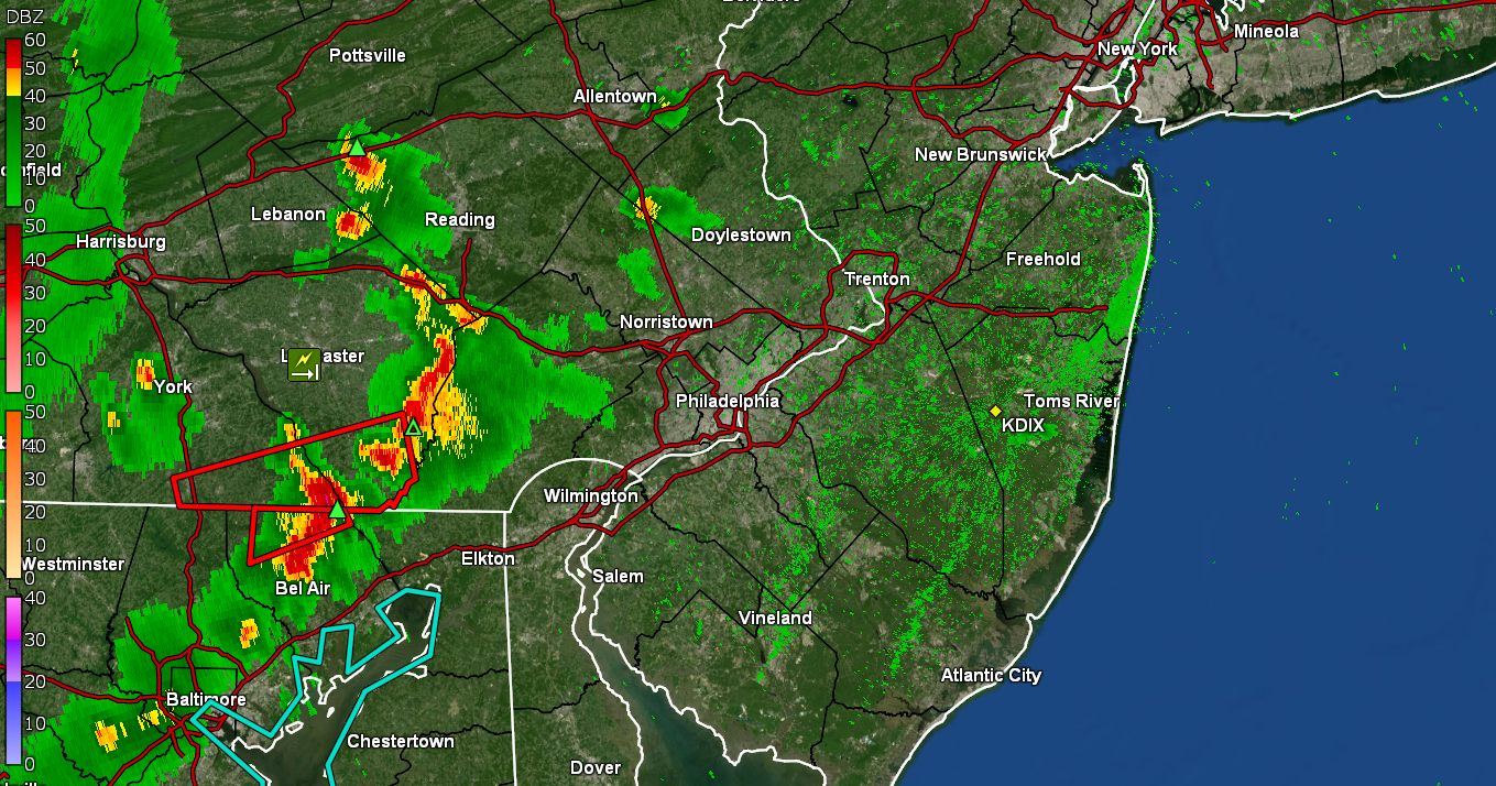
That is a wild-looking line! One of my sisters is down at the Phillies game and I pre-warned her. The city cancelled the concert and fireworks scheduled for tonight. I made it up to 92 before it clouded over and am currently at 86 with dp 73. -
E PA/NJ/DE Summer 2022 OBS Thread
Hurricane Agnes replied to Maxwell03's topic in Philadelphia Region
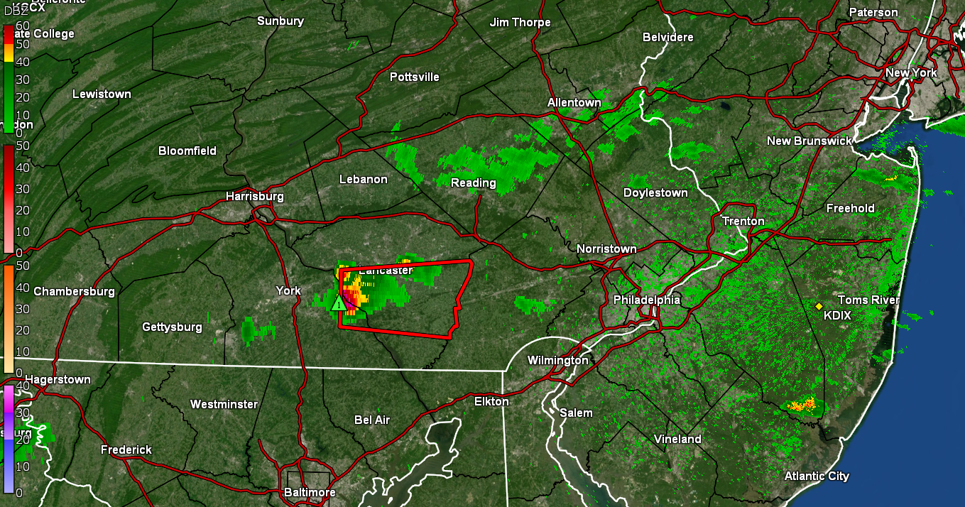
Here we go! Temp has hit 91 here and dp 72. Saw a nasty cell has popped up out in Lancaster.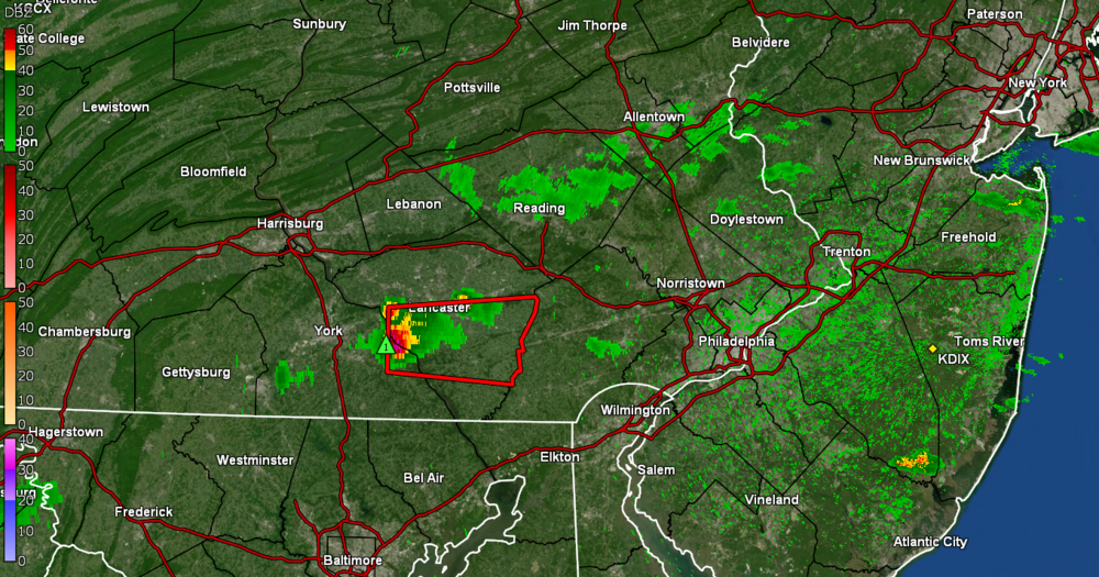
-
E PA/NJ/DE Summer 2022 OBS Thread
Hurricane Agnes replied to Maxwell03's topic in Philadelphia Region
Whatever was on the radar went scooting to the northeast, the cloud cover has dissipated for the most part, and the sun has come out. That has sent the temp on an upwards climb, along with the dp. Currently 82 with dp a steamy 76. -
E PA/NJ/DE Summer 2022 OBS Thread
Hurricane Agnes replied to Maxwell03's topic in Philadelphia Region
I sortof bottomed out at 75 (so far) this morning and it's currently overcast and 76 with dp 73, and some stuff slowly heading east. I did see that TS Colin formed this morning off the coast of SC and is expected to head ENE over the next couple days. Just based on this morning's cone, I would think this would cause some rip current/heavy surf issues along the Delaware and S. Jersey beaches right around July 4th.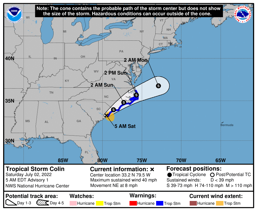
-
E PA/NJ/DE Summer 2022 OBS Thread
Hurricane Agnes replied to Maxwell03's topic in Philadelphia Region
Well that line fizzled before getting here although my Upper Darby sister texted that she got a couple minutes of rain and that was it (nothing here). Currently have the sun breaking through the clouds and 84, with dp 72 (which I guess is better than the 75 dp earlier). -
E PA/NJ/DE Summer 2022 OBS Thread
Hurricane Agnes replied to Maxwell03's topic in Philadelphia Region
Don't know how much of that line will survive but whatever antecedent clouds it threw this way have dropped the temps down to about 87 after an earlier intraday high of 93. Currently hazy and overcast with temp 89 and dp 74.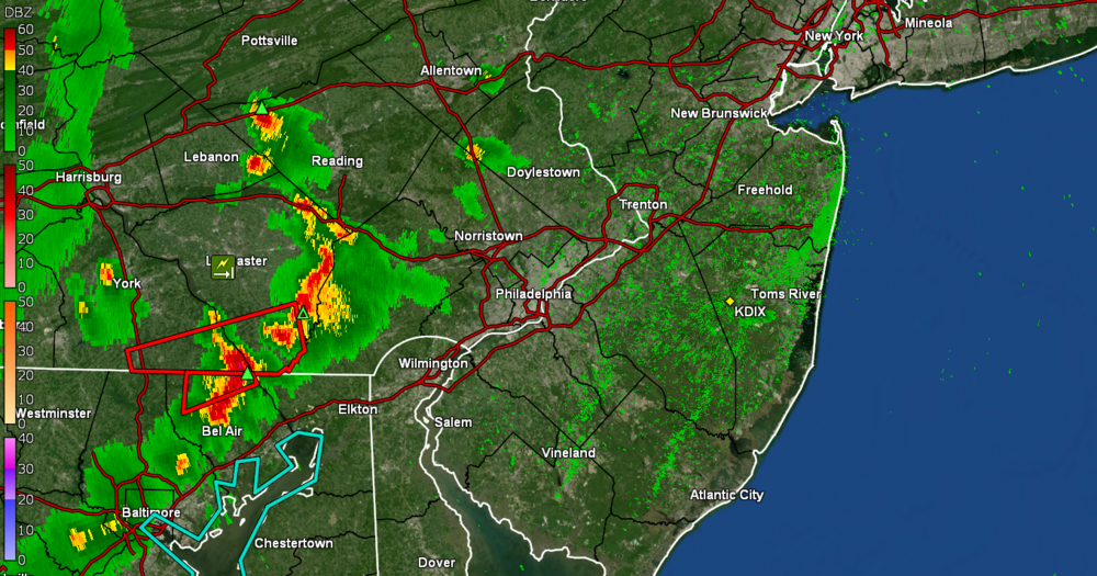
-
E PA/NJ/DE Summer 2022 OBS Thread
Hurricane Agnes replied to Maxwell03's topic in Philadelphia Region
Am above 90 now for the 7th time since May. Currently 91 with dp 75, which is scary. Lots of cumulus out there too. There is an active breeze although it probably works better when in the shade.