Hurricane Agnes
-
Posts
9,344 -
Joined
Content Type
Profiles
Blogs
Forums
American Weather
Media Demo
Store
Gallery
Everything posted by Hurricane Agnes
-
E PA/NJ/DE Spring 2022 OBS Thread
Hurricane Agnes replied to Hurricane Agnes's topic in Philadelphia Region
I got a total of 0.47" in the bucket so far with some light rain still going on. Temp down to 70 with dp 69. -
E PA/NJ/DE Spring 2022 OBS Thread
Hurricane Agnes replied to Hurricane Agnes's topic in Philadelphia Region
Right over top of them (am guessing all kinds of folks are looking out the window). -
E PA/NJ/DE Spring 2022 OBS Thread
Hurricane Agnes replied to Hurricane Agnes's topic in Philadelphia Region
TORW in Jersey.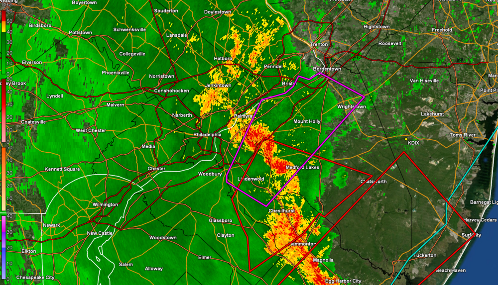
-
E PA/NJ/DE Spring 2022 OBS Thread
Hurricane Agnes replied to Hurricane Agnes's topic in Philadelphia Region
Line has sortof diffused itself as it approached and is over me with some light rain (heavier to the south. Currently have 0.04" in the bucket (including the earlier 0.01") with the temp at 75 and dp 71.
-
E PA/NJ/DE Spring 2022 OBS Thread
Hurricane Agnes replied to Hurricane Agnes's topic in Philadelphia Region
May hit here at the "heat of the day" although it's currently only 73 here but the dp is an awful 69. Had to turn the AC on just to get the humidity out of the house. It's like feast or famine. One day so dusty dry I could power the neighborhood with the static electricity and another day so damp and humid I need one of those Louisiana airboats to get to the kitchen. -
E PA/NJ/DE Spring 2022 OBS Thread
Hurricane Agnes replied to Hurricane Agnes's topic in Philadelphia Region
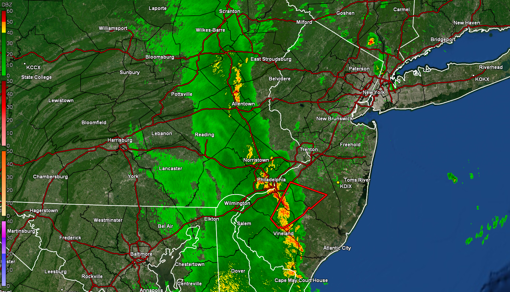
Norman lofting the Watches - -
E PA/NJ/DE Spring 2022 OBS Thread
Hurricane Agnes replied to Hurricane Agnes's topic in Philadelphia Region
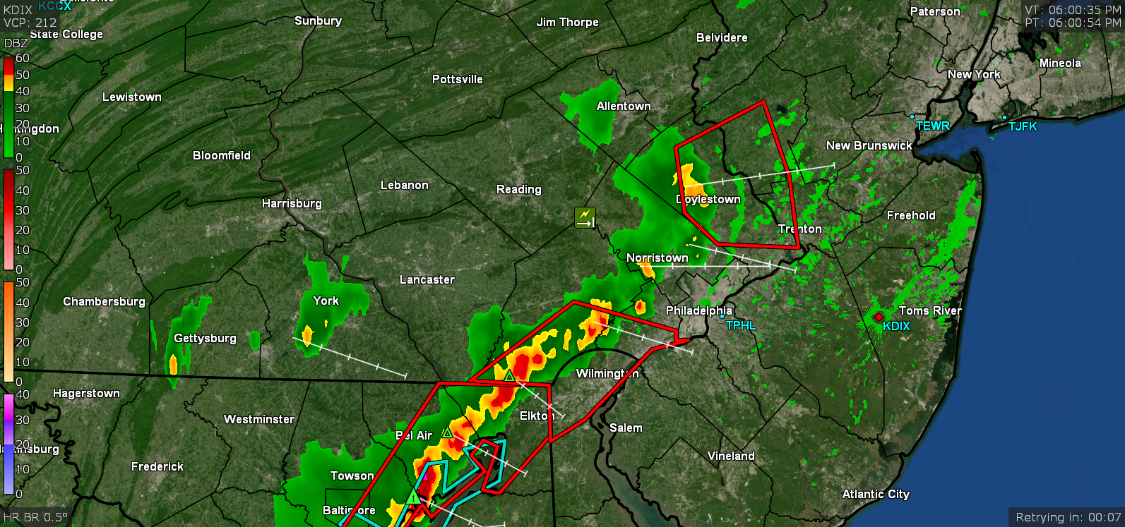
Was looking to see what area of the sky that might show up. It might be iffy here if high clouds roll in and apparently the meteors are expected to be faint. The burst is being predicted to apparently appear not far from the Big Dipper to get a point of reference. End of an era like when Elliot Abrams retired (3 years ago - seems like it was longer). Funny but when my sisters treated me to a trip to the Cheesecake Factory up at the Willow Grove Mall for my 50th birthday (I had never been to that one but had been to others around the country), Glenn and his wife were there too! My BIL ran right over to him and was chatting it up (since both had gone to Central High - although Glenn was in an earlier class). That was a couple months before he had to have his bypass surgery. The Inky had a tribute article about him and his hundreds of bow ties last weekend - https://www.inquirer.com/news/glenn-hurricane-schwartz-nbc10-bowties-retirement-20220521.html I recall earlier forecasts this week had Friday as a washout from early on but looks like that has been pushed back to the afternoon. A Flood Watch was issued though - I sort of bottomed out at 65 this morning and even picked up 0.02" before midnight and another 0.01" of precip. this morning before 6 am when there was some low stratus around. It's currently 66 with dp 66 so a bit soupy. -
E PA/NJ/DE Spring 2022 OBS Thread
Hurricane Agnes replied to Hurricane Agnes's topic in Philadelphia Region
SPC SWDY2 has the CWA in "Slight Risk" - Can definitely feel the humidity is up today and did get to 75 after a chilly low of 53. Currently overcast and 71 with dp 62. -
E PA/NJ/DE Spring 2022 OBS Thread
Hurricane Agnes replied to Hurricane Agnes's topic in Philadelphia Region
Ended up with a high of 70 yesterday and surprising low of 53 this morning (about 5 degrees cooler than yesterday's low). Had a warmer high today of 75. Currently mostly sunny and 70, with dp a comfortable 50. -
E PA/NJ/DE Spring 2022 OBS Thread
Hurricane Agnes replied to Hurricane Agnes's topic in Philadelphia Region
LOL They need to be watered more often when mother nature doesn't do it, but it's nice to sit outside on the patio and enjoy them! Am up to 68 with dp 51 and it's nice out as I weed (the weeds have been fierce this year). -
E PA/NJ/DE Spring 2022 OBS Thread
Hurricane Agnes replied to Hurricane Agnes's topic in Philadelphia Region
Yeah when you have them planted in the ground, they can handle it. But these are potted and not "hardened off" yet. The next couple days with overcast, are actually the best time to put them all out because I can avoid sun scald of the leaves until they adjust. I have a Dekopan mandarin that can go out but the other 3 citrus are limes (key lime, Thai lime, Australian red lime) and those are more sensitive to the cooler temps, and the plumies will end up with yellowing and dropping leaves if they have sudden or prolonged chill in the 50s (that's how they go dormant in winter in FL and HI). Forgot that I also have a fig, so that can actually go out in those temps. -
E PA/NJ/DE Spring 2022 OBS Thread
Hurricane Agnes replied to Hurricane Agnes's topic in Philadelphia Region
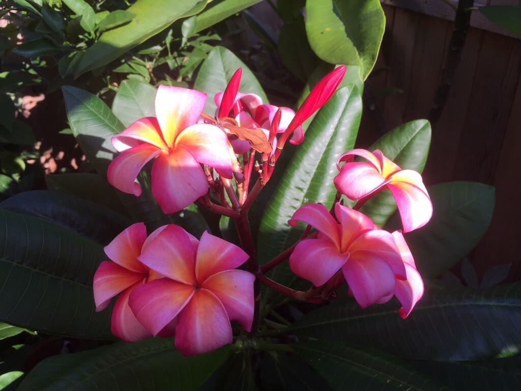
4 small citrus trees, a coffee plant, a tropical hibiscus, a stephanotis, and 2 plumerias including my big one that instead of dropping its old blooming inflo stalk this past winter (when I had it in a dark cool corner of the unfinished part of the basement), it started blooming from it again! That plumie is always a late bloomer - usually not until August. And it has a bunch more bloom buds on that inflorescence too. I guess that's a nice bonus but under the artificial lights, the bloom is yellow. In the sun, the flowers are normally spirals of light and hot pink with a little yellow in the center (pic below from about 4 years ago). The sun was trying to come out earlier here but it has clouded back over and temp is up a degree to 67 with dp 51. At least I do have the AC off.
-
E PA/NJ/DE Spring 2022 OBS Thread
Hurricane Agnes replied to Hurricane Agnes's topic in Philadelphia Region
66 here with dp 50 and overcast after some drizzle this morning (with a low of 60 earlier). I have some potted tropicals and subtropicals in my basement that are demanding to go out for the season and I usually get them out just before or around now, but some don't like below mid-50s temps either, which I have had most of the overnights this month except for a handful. I gotta get them up and out this week though. -
E PA/NJ/DE Spring 2022 OBS Thread
Hurricane Agnes replied to Hurricane Agnes's topic in Philadelphia Region
Ended up with another "surprise" 0.01" of rain after midnight (I saw the radar stuff the night before coming in from the SW although it mostly diffused), and bottomed out at 58 earlier this morning. It's currently a breezy 66 and mostly sunny with dp a more comfortable 51. -
E PA/NJ/DE Spring 2022 OBS Thread
Hurricane Agnes replied to Hurricane Agnes's topic in Philadelphia Region
Sun finally broke out. Temp recovered to 73 with dp 69. -
E PA/NJ/DE Spring 2022 OBS Thread
Hurricane Agnes replied to Hurricane Agnes's topic in Philadelphia Region
Sky is brightening and got a grand total of 0.01". My high did end up being 90 and temp is down to 72 with dp 68. -
E PA/NJ/DE Spring 2022 OBS Thread
Hurricane Agnes replied to Hurricane Agnes's topic in Philadelphia Region
Starting to get some light rain. Nothing measurable yet as the line has bee fizzling as it slides in. Temp is down to 76 with dp 67. -
E PA/NJ/DE Spring 2022 OBS Thread
Hurricane Agnes replied to Hurricane Agnes's topic in Philadelphia Region
Some kind of outflow boundary from that cell in Bucksco blew through here and temp has dropped. Now down to 80 with dp 65. Getting convection on the lightning detector.
-
E PA/NJ/DE Spring 2022 OBS Thread
Hurricane Agnes replied to Hurricane Agnes's topic in Philadelphia Region
Wait... there's more! -
E PA/NJ/DE Spring 2022 OBS Thread
Hurricane Agnes replied to Hurricane Agnes's topic in Philadelphia Region
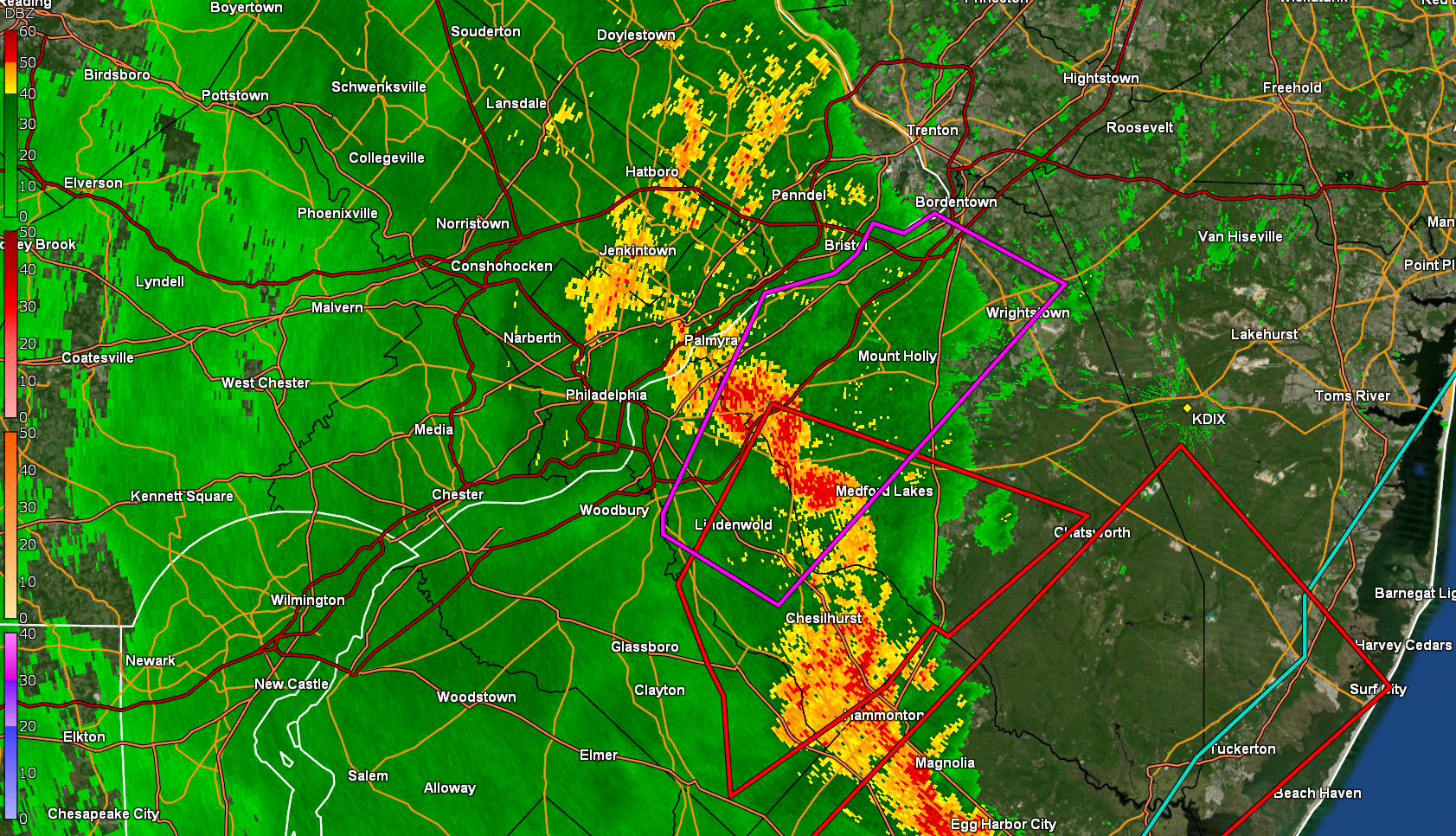
Mt. Holly is busy! -
E PA/NJ/DE Spring 2022 OBS Thread
Hurricane Agnes replied to Hurricane Agnes's topic in Philadelphia Region
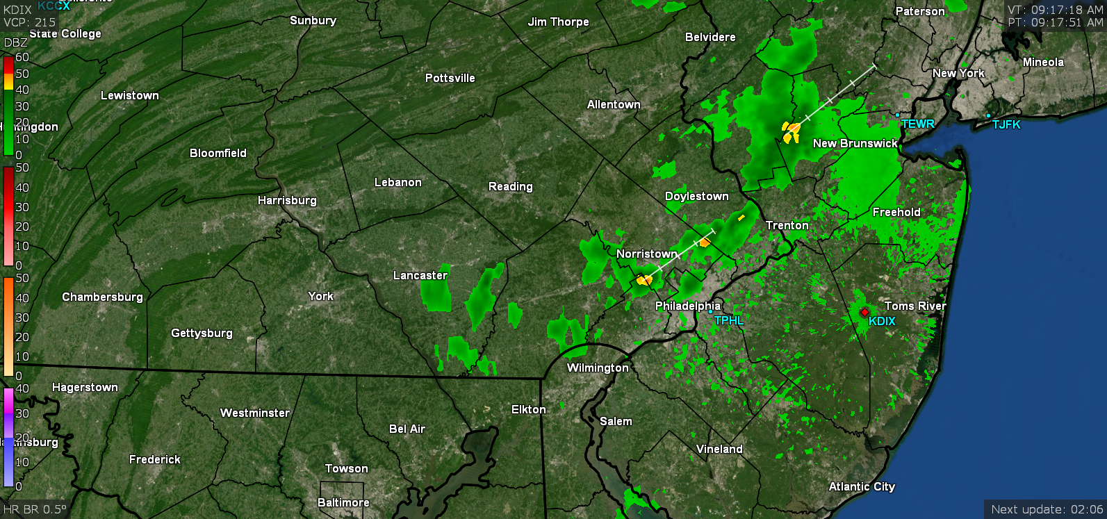
Another warning up - -
E PA/NJ/DE Spring 2022 OBS Thread
Hurricane Agnes replied to Hurricane Agnes's topic in Philadelphia Region
Game on! -
E PA/NJ/DE Spring 2022 OBS Thread
Hurricane Agnes replied to Hurricane Agnes's topic in Philadelphia Region
I did hit 90 today so far but it's currently "back down to" 89 but with dp 73. -
E PA/NJ/DE Spring 2022 OBS Thread
Hurricane Agnes replied to Hurricane Agnes's topic in Philadelphia Region
Norman up with the Watch - -
E PA/NJ/DE Spring 2022 OBS Thread
Hurricane Agnes replied to Hurricane Agnes's topic in Philadelphia Region
I bottomed out at 72 earlier this morning and then it clouded over with some pop-ups in the vicinity. I may get fringed by one. Currently overcast and 76 with dp 71.