Hurricane Agnes
-
Posts
9,344 -
Joined
Content Type
Profiles
Blogs
Forums
American Weather
Media Demo
Store
Gallery
Everything posted by Hurricane Agnes
-
Old Crappy Coatesville Snowfall Records!
Hurricane Agnes replied to LVwxHistorian's topic in Philadelphia Region
You're welcome. Figured it would be your "summer reading"! I'm already flopping around at the bottom of that rabbit hole myself going through that 1889 pt. 1 file. -
E PA/NJ/DE Spring 2022 OBS Thread
Hurricane Agnes replied to Hurricane Agnes's topic in Philadelphia Region
Got some RERs up - so far 1 new record and 2 "ties" - My high for today ended up being 94 and I'm currently at 90 and mostly sunny with dp 69. -
Old Crappy Coatesville Snowfall Records!
Hurricane Agnes replied to LVwxHistorian's topic in Philadelphia Region
Found the 1888 data. It is in the 1889 Pt. 1 PDF (selectable via a drop-down menu) at NOAA's Signal Corps data at that link - https://library.noaa.gov/Collections/Digital-Docs/Signa-Corps-WB-Annual Have to scroll down but for example, starting from "pg 254" of Pt. 1, you start to see the individual observer station reports (earlier tables appeared to be the data for full stations that had all the instruments). So the first "Coatesville" reference (just from a quick scan) appears on "pg. 285" (the page number printed on the document) and it appears that the first obs readings started in March of 1888 for monthly/annual mean temp. Then on "pg. 328" are the "max/min/range" temps for Coatesville Mar. - Dec. 1888. Then the piece de resistance - the precip for Mar - Dec. 1888 in Coatesville (doesn't distinguish frozen from liquid, it appears to just be total qpf). (I blame you for this! ) -
Old Crappy Coatesville Snowfall Records!
Hurricane Agnes replied to LVwxHistorian's topic in Philadelphia Region
From what I understand, the Army "Signal Corps" was "officially" recording weather observations before the Weather Bureau was formed, so I expect he may have been submitting his observations to them. And LOL!!! I just found this site - https://library.noaa.gov/Collections/Digital-Docs/Signa-Corps-WB-Annual Guaranteed you'll go crazy there - I just randomly pulled up the 1888 "annual report" which is a PDF and there are summary observations in there by state (just scanned and saw one for Kansas), plus other odds and ends "military" stuff. And yup - I can imagine what he had seen over that time and how the place changed over the years (there were mergers of adjacent villages to form what is now "Coatesville"). -
E PA/NJ/DE Spring 2022 OBS Thread
Hurricane Agnes replied to Hurricane Agnes's topic in Philadelphia Region
Posted at the link. And I briefly hit 94 for a high so far but am currently at 93 with dp 70. I did venture out to put my patio umbrella up and it's the good old-fashioned blast furnace of last year out there. -
Old Crappy Coatesville Snowfall Records!
Hurricane Agnes replied to LVwxHistorian's topic in Philadelphia Region
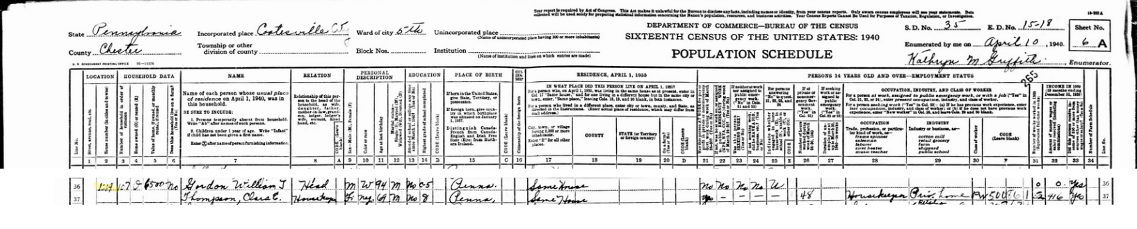
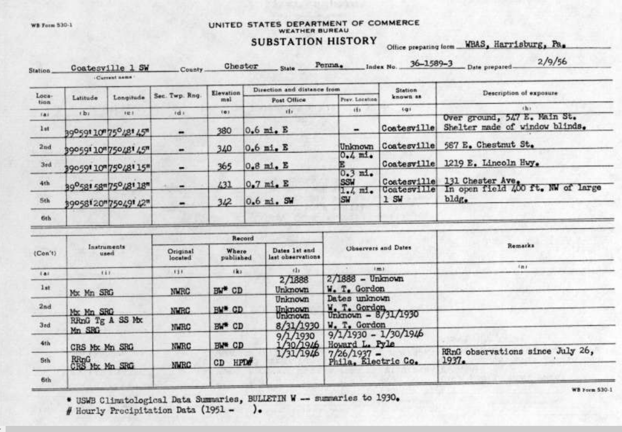
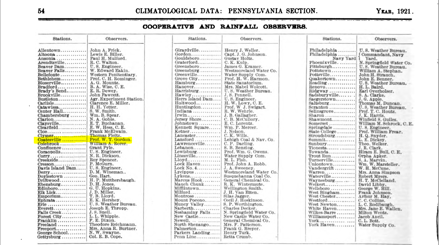
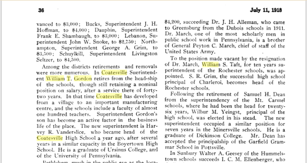
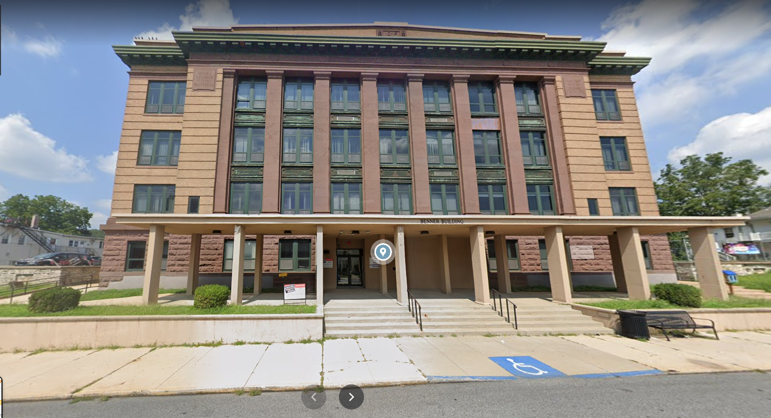
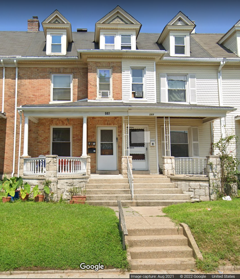
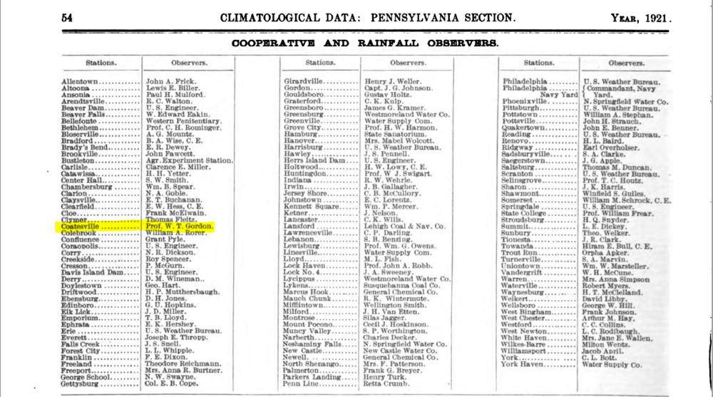
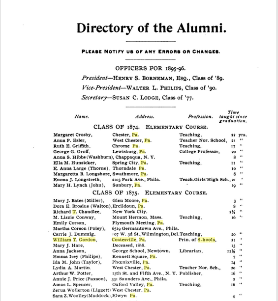
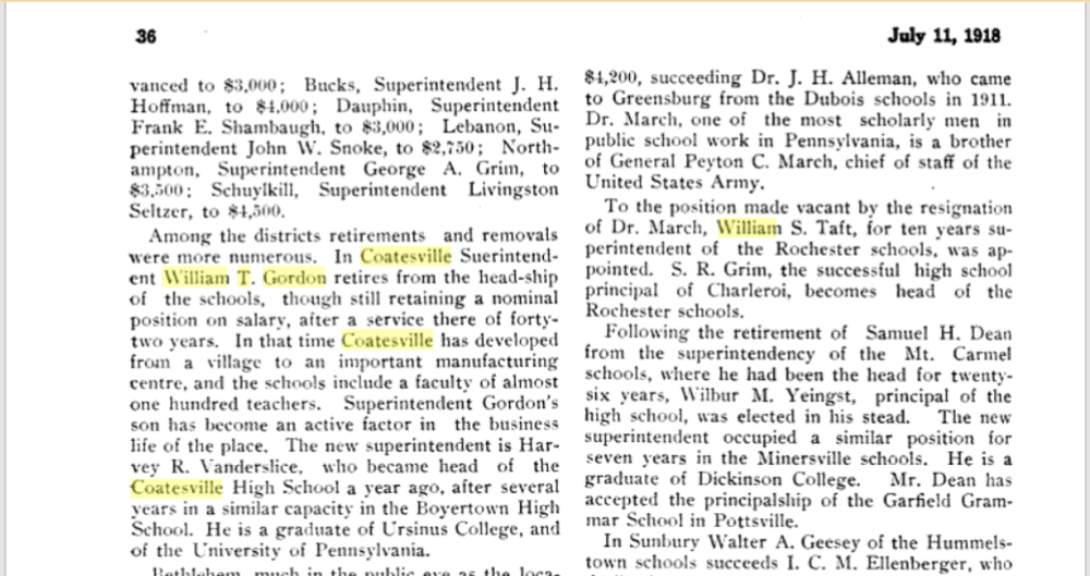
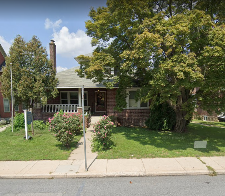
After the meltdown in this thread, I ended up going on a journey back in February, into the history of Coatesville, a place so close but that I really had little background on (other than one of my lab benchmates when I had first started at that job almost 40 years ago, lived there). I was really surprised that there was an actual steel mill there (that had specialized in rolled and cast parts, and is still there). But the other thing I noticed was that there were several references, including schools, that were named "Gordon" and that started me down the rabbit hole. So looking up this name (and knowing when his observer records were done), I stumbled on a 1940 Census entry, took a screen shot snip of the Census page's header and one of the entry with the name, and combined them as a single image (attached). Based on the age listed in 1940 as being "94", that would make his birth year 1846. The address on that entry "1219" corresponded to that page's "E. Lincoln Highway" list of homes. And THAT corresponded with one of the addresses listed for W.T. Gordon for the "Substation History" as enumerated in 1956 (also attached). But here is the kicker, and I had to eventually take a break obtaining a "smoking gun" connection, but I also found a 1921 reference to the Climatological Observers that year where his name appears, and it includes the title "Prof." (for "Professor" - the old designation for teachers), and that snapshot is attached. And that sent me back, back into time to find that he graduated from what was then West Chester State Normal School in 1875, which is of course now known as West Chester (State) University (attached) and he was listed in that 1895/1896 Directory of alumni as being "Prin. of Schools" ("Prin" for "Principal"). And this then lead me to one of many vaunted references to his "retirement" in 1918 as "Superintendent of Schools", "after a service there of forty-two years" (attached). So this "W.T. Gordon" ("William T. Gordon") was appointed "Superintendent of the Coatesville Schools in 1876. So based on the Observer records, he actually started out as one of the earliest observers when the program first started under the Weather Bureau (under USDA) in the early 1890s. I did some "modern day" screenshots of the observer locations of the 2 houses that were listed (1st was "547 E. Main St." later moving the obs to "567 E. Chestnut St" and 2nd 1218 E. Lincoln Highway") - both attached below. It's probable that different houses were there on those properties back in the late 1800s and through to at least the 1940s when he was still alive, but it was interesting to see nonetheless. Note the first "building" is obviously newish and wasn't there back in the late 1800s but is on the lot where the first obs were done. Assuming this is all the same guy, it makes perfect since that an educational professional (and Superintendent) who perhaps had this as a hobby, would be so detailed with the records. I wouldn't be surprised if some students may have done readings too... There's quite a bit there about this family (and his sons including one who worked at the steel mill). So like I said, I went down the rabbit hole and some of it was also due to a guy who has a Facebook page with literally thousands of archival pics of Coatesville from many eras including going back into the 1800s. His page is here - https://www.facebook.com/A-History-of-Coatesville-Pa-Mark-Ford-Webmaster-675536869267910/ (I don't do Facebook but if there are public-accessible parts of a Facebook page like this one, that are interesting, I'll go peruse them and I spent days going through some of the pics that this guy had)


-
E PA/NJ/DE Spring 2022 OBS Thread
Hurricane Agnes replied to Hurricane Agnes's topic in Philadelphia Region
Maybe I'll put it in that thread then because what I believe I have found is the reason why he was so meticulous with the record-keeping (assuming this is the same guy). -
E PA/NJ/DE Spring 2022 OBS Thread
Hurricane Agnes replied to Hurricane Agnes's topic in Philadelphia Region
Let me go through and gather what I saved in my "electronic folder" on who I believe is him (including some screenshots of stuff). Was debating where to stick it since I am trying to avoid the trolling threads where his name came up, so may want to stick it in one of your other threads. -
E PA/NJ/DE Spring 2022 OBS Thread
Hurricane Agnes replied to Hurricane Agnes's topic in Philadelphia Region
Your post made me "look" and I have now hit my first 90 of 2022. Dewpoint is a horrible 70 and it's mostly sunny. -
E PA/NJ/DE Spring 2022 OBS Thread
Hurricane Agnes replied to Hurricane Agnes's topic in Philadelphia Region
You realize you made me go deep down a rabbit hole a few months ago regarding that guy and who I believe he is, resulting in some interesting info (based on census data and township historical docs) but that will be for another day. -
E PA/NJ/DE Spring 2022 OBS Thread
Hurricane Agnes replied to Hurricane Agnes's topic in Philadelphia Region
Have the expected fog this morning although with vis < 1/4 mile, so right around the "dense fog" category. I know that as soon as this lifts (and literally as I type this, it appears to be starting to get brighter), and the sun comes out, look out! Currently a foggy and misty 67 with dp 67. -
E PA/NJ/DE Spring 2022 OBS Thread
Hurricane Agnes replied to Hurricane Agnes's topic in Philadelphia Region
Extended Warning times - -
E PA/NJ/DE Spring 2022 OBS Thread
Hurricane Agnes replied to Hurricane Agnes's topic in Philadelphia Region
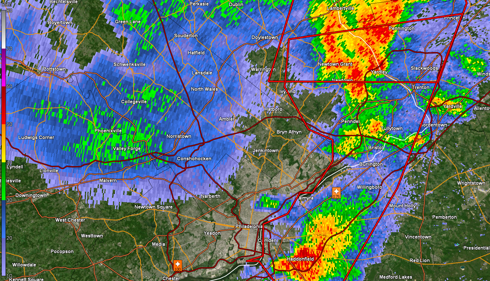
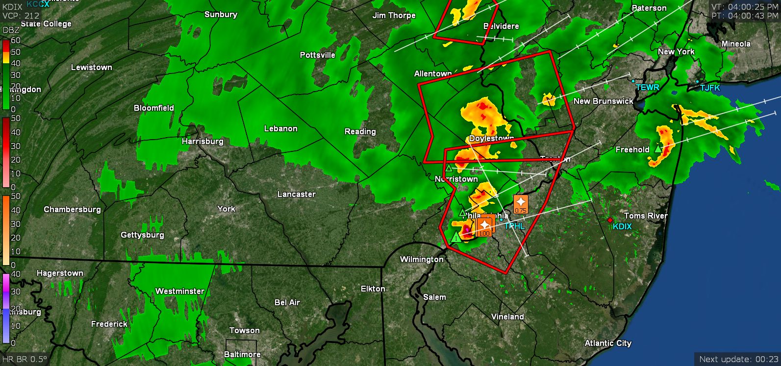
Looks like a little light batch is headed your way... although will have to see if it fizzles out. It's hard to see on the Level3 radar but is appearing on the Level 2.
-
E PA/NJ/DE Spring 2022 OBS Thread
Hurricane Agnes replied to Hurricane Agnes's topic in Philadelphia Region
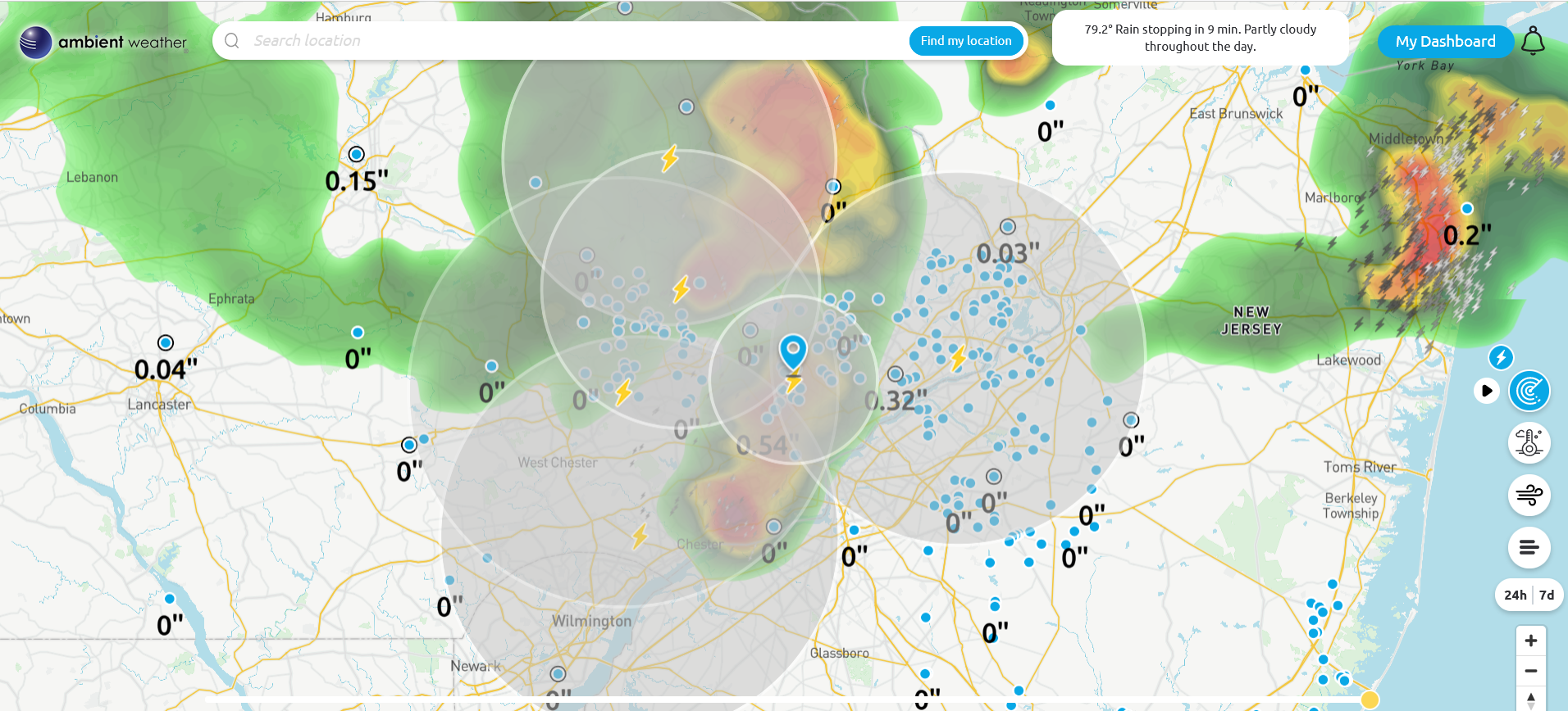
Sun is trying to come out. Temp at 71 with light rain and dp 69. Now up to 0.70" of rain for the day. -
E PA/NJ/DE Spring 2022 OBS Thread
Hurricane Agnes replied to Hurricane Agnes's topic in Philadelphia Region
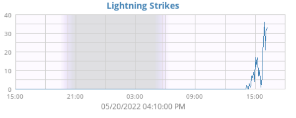
Lots of convection has been going on!
-
E PA/NJ/DE Spring 2022 OBS Thread
Hurricane Agnes replied to Hurricane Agnes's topic in Philadelphia Region
Getting some moderate rain again. Now up to 0.41" with temp at 75 and dp 71.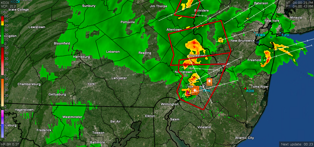
-
E PA/NJ/DE Spring 2022 OBS Thread
Hurricane Agnes replied to Hurricane Agnes's topic in Philadelphia Region
A wait, there's more! -
E PA/NJ/DE Spring 2022 OBS Thread
Hurricane Agnes replied to Hurricane Agnes's topic in Philadelphia Region
-
E PA/NJ/DE Spring 2022 OBS Thread
Hurricane Agnes replied to Hurricane Agnes's topic in Philadelphia Region
And more - -
E PA/NJ/DE Spring 2022 OBS Thread
Hurricane Agnes replied to Hurricane Agnes's topic in Philadelphia Region
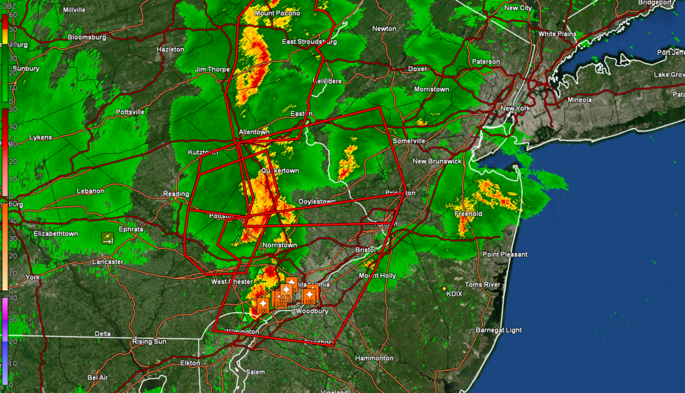
Look s like something headed for BBasile. Temp up to 78 and just all unstable out there. Dp is 73. -
E PA/NJ/DE Spring 2022 OBS Thread
Hurricane Agnes replied to Hurricane Agnes's topic in Philadelphia Region
Energizer Bunny Staarmann. -
E PA/NJ/DE Spring 2022 OBS Thread
Hurricane Agnes replied to Hurricane Agnes's topic in Philadelphia Region
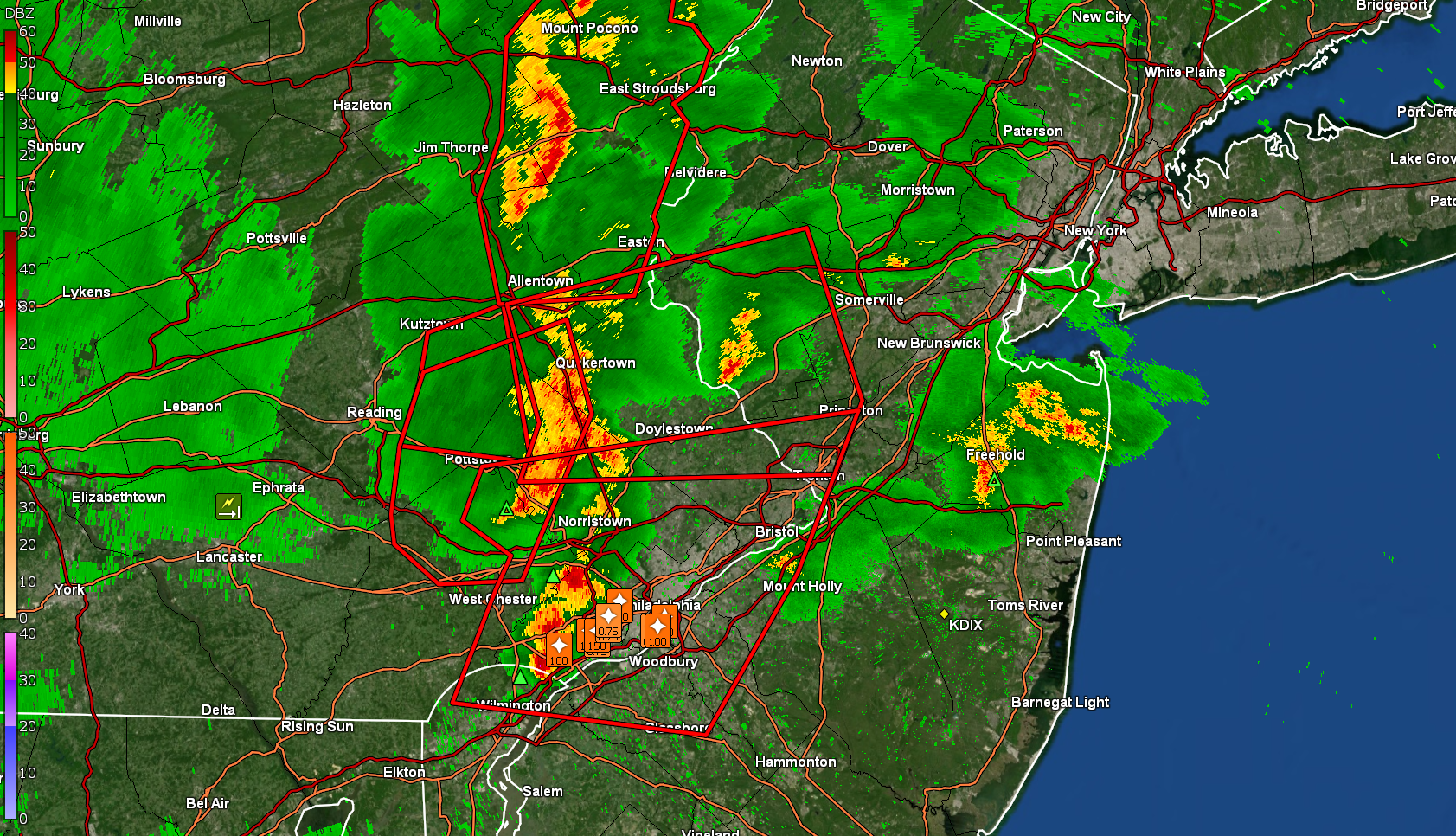
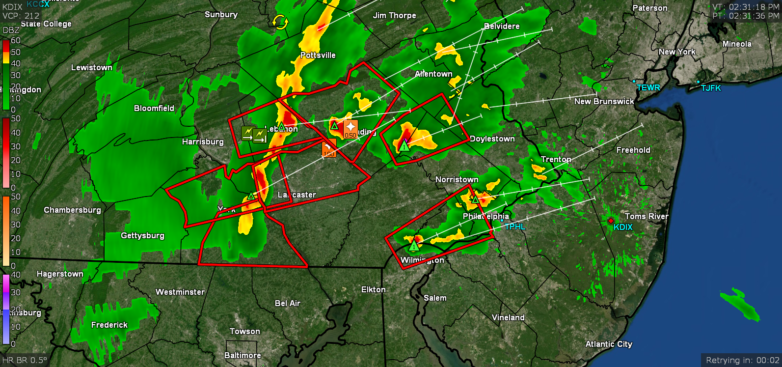
New Warning - -
E PA/NJ/DE Spring 2022 OBS Thread
Hurricane Agnes replied to Hurricane Agnes's topic in Philadelphia Region
Sun back out and temp had dropped to 73 but has recovered to 75 with dp 71. Ended up with 0.30" with from that cell. -
E PA/NJ/DE Spring 2022 OBS Thread
Hurricane Agnes replied to Hurricane Agnes's topic in Philadelphia Region
Latest Warning up - -
E PA/NJ/DE Spring 2022 OBS Thread
Hurricane Agnes replied to Hurricane Agnes's topic in Philadelphia Region
Under a heavy rain cell with 3/4" per har rates. Currently hae 0.12" and a gully washer going on. Temp down to 76 with dp 70.