Hurricane Agnes
-
Posts
9,344 -
Joined
Content Type
Profiles
Blogs
Forums
American Weather
Media Demo
Store
Gallery
Everything posted by Hurricane Agnes
-
E PA/NJ/DE Summer 2022 OBS Thread
Hurricane Agnes replied to Maxwell03's topic in Philadelphia Region
It's definitely off to the races here this morning with temp at 87 and dp 75. Low was 70 just after 4 am with the steamy windows alert, so it didn't bother to wait for full radiational cooling around sunrise to start shooting up. I did step outside earlier to put an ant bait in a potted citrus and ack. -
E PA/NJ/DE Summer 2022 OBS Thread
Hurricane Agnes replied to Maxwell03's topic in Philadelphia Region
Had an unexpected high of 90 today (3rd for the month of June and #6 since May) and the dp managed to keep itself in check, generally staying in the upper 50s and low 60s. It's currently bopping between 87 and 88, partly sunny with lot of cumulus, and sporting a dp of 62. -
E PA/NJ/DE Summer 2022 OBS Thread
Hurricane Agnes replied to Maxwell03's topic in Philadelphia Region
SPC SWDY3 has the CWA penciled in for either Marginal or Slight Risk for severe for Saturday - Currently clear and 65 IMBY with dp 63. -
E PA/NJ/DE Summer 2022 OBS Thread
Hurricane Agnes replied to Maxwell03's topic in Philadelphia Region
I had a somewhat surprising low of 59 this morning and made it up to 86 as a high. Thanks to relatively modest dps, it made for an acceptable early summer day ahead of the upcoming torch. It's currently partly cloudy and 82 although the dp is slowly creeping up and is 64, after being in the upper 50s much of the day. -
E PA/NJ/DE Summer 2022 OBS Thread
Hurricane Agnes replied to Maxwell03's topic in Philadelphia Region
I think I had the makings for a nice sunset but it wasn't colorful enough to qualify. I would have loved to have gotten that much here so I could coast the rest of the week before the torch comes, but alas. Ended up with a low of 63 this morning about 15 minutes after sunrise and well after the cold front finally came through. It's currently mostly sunny and 66 with dp a manageable 56. I could easily spot when that front came through just after midnight as the change was pretty dramatic!!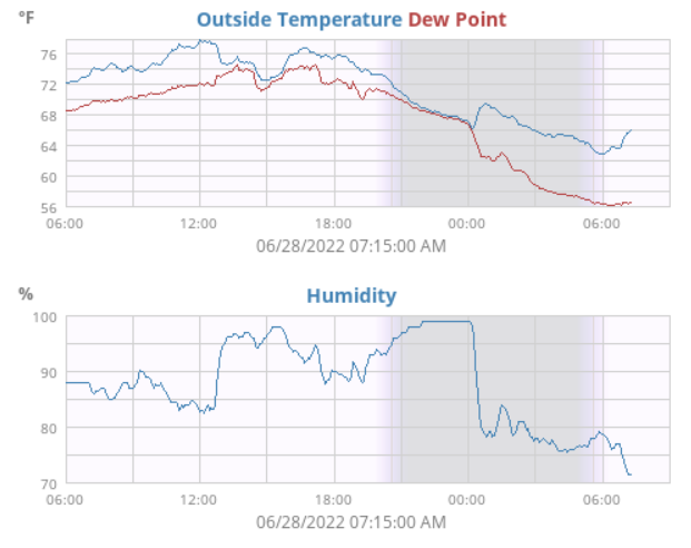
-
E PA/NJ/DE Summer 2022 OBS Thread
Hurricane Agnes replied to Maxwell03's topic in Philadelphia Region
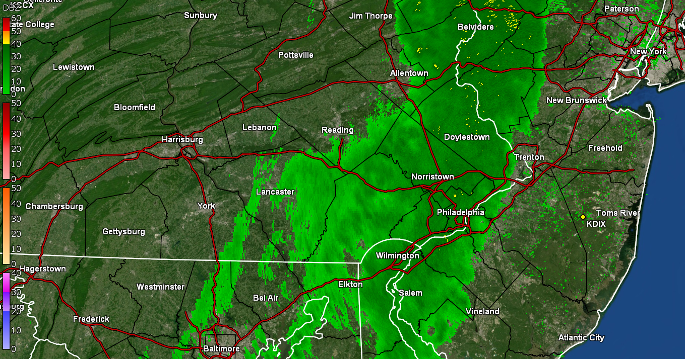
Well the sun popped out but there are still leftover clouds and I did see the cells that bubbled up in S. Philly that traveled across the river into Camden County. Made it up to 78 and after a steamy window day, it's currently 74 with dp still up there at 71 (cold front is near but not through with the drier air yet). Ended up with 0.36" in the bucket. -
E PA/NJ/DE Summer 2022 OBS Thread
Hurricane Agnes replied to Maxwell03's topic in Philadelphia Region
Just missed 90 yesterday with a high of 89. Had a low of 72 this morning and what sun there was early on, quickly disappeared fairly rapidly. Have had a couple spotty sprinkles enough to moisten the sidewalk but non-measurable, and it's currently overcast and 77 with dp a sauna-like 72. Need a good soaking rain to keep the plants happy. -
E PA/NJ/DE Summer 2022 OBS Thread
Hurricane Agnes replied to Maxwell03's topic in Philadelphia Region
After a 66 low this morning, I did make it to 91 as a high. Although some of the high dps this morning did finally mix out, it was still a bit uncomfortable. It's currently partly cloudy and 84 with dp 68. This was the 2nd 90+ day this month and last month there were 3, so total 5 days that have reached 90+ this season so far. -
E PA/NJ/DE Summer 2022 OBS Thread
Hurricane Agnes replied to Maxwell03's topic in Philadelphia Region
Ended up with a high of 72 yesterday and 0.60" of rain. This morning started with some low stratus but has now evolved into fog with <1/4 mile vis. The low so far was 59 and it's currently foggy and 60 with dp 60. -
E PA/NJ/DE Summer 2022 OBS Thread
Hurricane Agnes replied to Maxwell03's topic in Philadelphia Region
Ended up with a high of 77 yesterday and low of 62 this morning and that slooooowwwww moving band has finally gotten here to give my plants a "natural drink" ahead of this weekend. Currently have light - moderate rain with a temp of 64 and dp 63. So far have 0.29" in the bucket.
-
E PA/NJ/DE Summer 2022 OBS Thread
Hurricane Agnes replied to Maxwell03's topic in Philadelphia Region
I had a little passing shower yesterday that deposited 0.02" of rain, but other than that, had a low of 63 this morning and it has progressively clouded up and is a breezy 75 with dp 66. -
E PA/NJ/DE Summer 2022 OBS Thread
Hurricane Agnes replied to Maxwell03's topic in Philadelphia Region
I bottomed out at 59 around 2 am and the temps slowly crept back up to the 60s, dragging the dps up too. Did see some cool bubble-wrap stratus earlier this morning. It's currently an increasingly overcast 70 with a noticeably more humid dp of 58. -
E PA/NJ/DE Summer 2022 OBS Thread
Hurricane Agnes replied to Maxwell03's topic in Philadelphia Region
The people in the PNW whine about being unable to grow tomatoes there in summer because they normally have "cool" summers, punctuated by occasional heatwaves. Apparently many never bought ACs there because of that, so if they were "extra cold", it wouldn't be that much of a stretch from their norm. Meanwhile I did make it up to 81 today as a high and it's currently partly cloudy and 70 with dp 48 about 12 minutes before sunset. -
Old Crappy Coatesville Snowfall Records!
Hurricane Agnes replied to LVwxHistorian's topic in Philadelphia Region
When I was doing my deep dives, I discovered a possible reason why that year and month and I expected it was because of a HUGE blizzard dubbed the "Great Blizzard of 1888" that happened in March of that year! https://www.wfmz.com/features/historys-headlines/october-blizzard-sparks-memories-of-the-great-blizzard-of-1888/article_ada2716a-8ff8-5c0c-afde-160ef30e506b.html https://www.inquirer.com/philly/columnists/mike_newall/snow-storm-philadelphia-weather-mike-newall-20180322.html (Clipping from a page one story in March 13, 1888 Philadelphia Inquirer Philadelphia Inquirer) So if anything as a major weather event, that blizzard was probably the trigger for interest for people in this area. -
E PA/NJ/DE Summer 2022 OBS Thread
Hurricane Agnes replied to Maxwell03's topic in Philadelphia Region
Just yesterday I was reading about a newly-discovered polar bear population that was found in an odd location - SE Greenland - https://www.nationalgeographic.com/animals/article/why-this-newly-identified-polar-bear-subpopulation-is-so-special and I think some of this anomalous chill may be coming from the glacial melt in Greenland. Did a quickie data lookup of the past 90 days and it's wild how PA stands out in the anomalous category!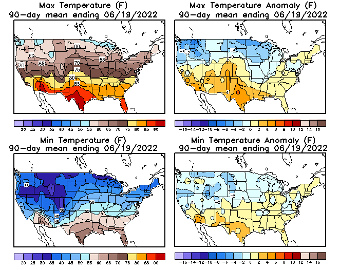
-
E PA/NJ/DE Summer 2022 OBS Thread
Hurricane Agnes replied to Maxwell03's topic in Philadelphia Region
This past year, I got more frozen in March than December! I can save on electric for the AC (I guess until September). -
E PA/NJ/DE Summer 2022 OBS Thread
Hurricane Agnes replied to Maxwell03's topic in Philadelphia Region
Fall will be the new "summer". The whole damn "met seasons" have shifted 3 months! Winter in spring, spring in summer, summer in fall, and fall in winter. I do remember a few somewhat "mild" July 4ths but they are very rare. The last were July 4, 2014 with a high @78 and July 4, 2015 with a high @77. Oddly enough, those years were El Nino years. -
E PA/NJ/DE Summer 2022 OBS Thread
Hurricane Agnes replied to Maxwell03's topic in Philadelphia Region
My final "low" was 54 about 10 minutes after sunrise this morning and I'm currently a mostly sunny 78 with dp 43. -
E PA/NJ/DE Summer 2022 OBS Thread
Hurricane Agnes replied to Maxwell03's topic in Philadelphia Region
Looks like the more northern parts of the CWA are getting those near-record low temps - That forest fire in S. Jersey is showing up on the radar too! So far, my low this morning has been 54, which is my current temp at post time. -
E PA/NJ/DE Summer 2022 OBS Thread
Hurricane Agnes replied to Maxwell03's topic in Philadelphia Region
Was surprised to still be at 55 at 4 am this morning and it could be because of the occasional puffs of breeze overnight and scattered clouds overhead. Currently 55 with some cirrus to the east, and dp 42. -
E PA/NJ/DE Summer 2022 OBS Thread
Hurricane Agnes replied to Maxwell03's topic in Philadelphia Region
Thanks to an active breeze overnight, I only bottomed out at 54 just before 6 am and the temp has been on the rise since. It's currently sunny with lots of blue sky and a temp of 61, along with a dp that is 42. Definitely a throw open the windows/make use of the screen doors day! -
E PA/NJ/DE Summer 2022 OBS Thread
Hurricane Agnes replied to Maxwell03's topic in Philadelphia Region
After a low of 64 this morning, my "high" was actually just after midnight at 75 and I was basically running in the upper 60s much of the rest of the day. It's currently clear about 15 minutes before sunset and 64 with dp now down to 45. -
E PA/NJ/DE Summer 2022 OBS Thread
Hurricane Agnes replied to Maxwell03's topic in Philadelphia Region
As a follow-up - this is what got to me the most back then... This was what was named the "Doodad Bridge", a rope/plank bridge that crossed a part of Swamp Creek back then - I In 1971 when I was first there, there was a wooden platform at the top of wood pylons, with a wooden ladder that would be climbed to access that bridge. Returning in 1972 after Hurricane Agnes, the entire assembly (pylons and platform) had been dislodged and overturned, leaving the bridge partially submerged in the creek, so it was completely unusable. When I returned 4 years later, the bridge had been repaired and the wood pylons and platform replaced with a "scout-enhanced" platform base of concrete (I think with a new wood platform for access via a ladder), where apparently after the main concrete footings and base structures were created, the attendees during the time of the completion, were each able to "add" to the base with a trowelful of concrete slapped onto the bottom where they then could add their initials (or whatever could fit) into the wet concrete "additions". Many years later out of curiosity searching for what it looked like today, I saw where apparently that whole structure was removed and replaced with what they call a "pedestrian bridge" (a "weathered" pre-fab steel structure) in 2008 - https://divingconstruction.com/girl-scout-bridge/ I did just spot a pic someone uploaded that appears to show it in the '80s before that above replacement was done (in the background at the top of the picture) - It was pretty obvious why they call it "Swamp Creek". And as an obs - It was 71 here this morning when I got up and eventually drifted down to 69 as a low before heading back up (although it is bopping back and forth between 69 and 70 with an apparent secondary cold front moving in). It's currently 71 with dp that is a more pleasant 53, and partly sunny, with lots of cumulus around. -
E PA/NJ/DE Summer 2022 OBS Thread
Hurricane Agnes replied to Maxwell03's topic in Philadelphia Region
LOL - Mt. Holly Climatology section went from possible "record highs" for today - to possible "record lows" for tomorrow! -
E PA/NJ/DE Summer 2022 OBS Thread
Hurricane Agnes replied to Maxwell03's topic in Philadelphia Region
Made it up to 93 as a high today with a HI (per my weewx) of 100.4. Thankfully the cold front moved through and dropped the dewpoint out of the 60s. In any case, it's still warm out and currently clear and 83 with dp 58.