Hurricane Agnes
-
Posts
9,344 -
Joined
Content Type
Profiles
Blogs
Forums
American Weather
Media Demo
Store
Gallery
Everything posted by Hurricane Agnes
-
E PA/NJ/DE Spring 2022 OBS Thread
Hurricane Agnes replied to Hurricane Agnes's topic in Philadelphia Region
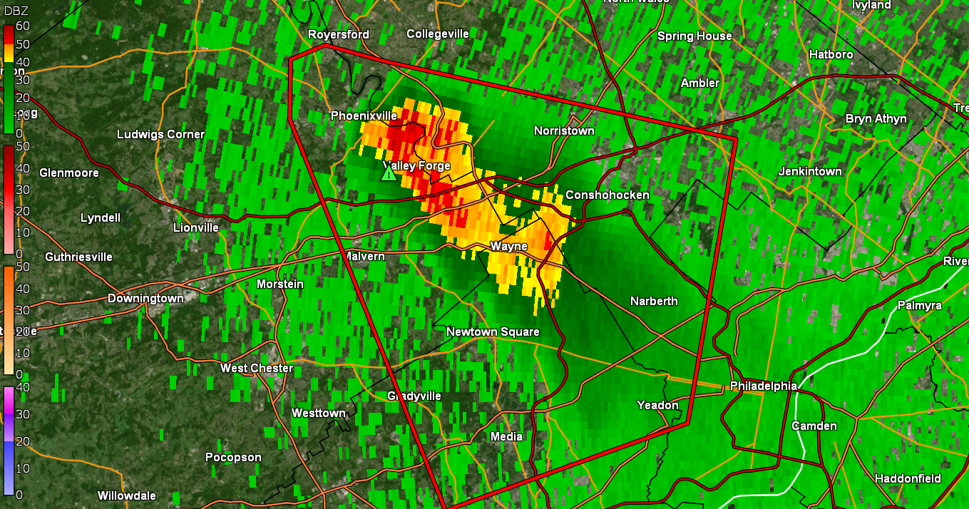
It may end up side-swiping me to the south but that cell has been generally stationary.
-
E PA/NJ/DE Spring 2022 OBS Thread
Hurricane Agnes replied to Hurricane Agnes's topic in Philadelphia Region
Yeah it has been sortof undulating in one place. -
E PA/NJ/DE Spring 2022 OBS Thread
Hurricane Agnes replied to Hurricane Agnes's topic in Philadelphia Region
Has some towering cloud tops.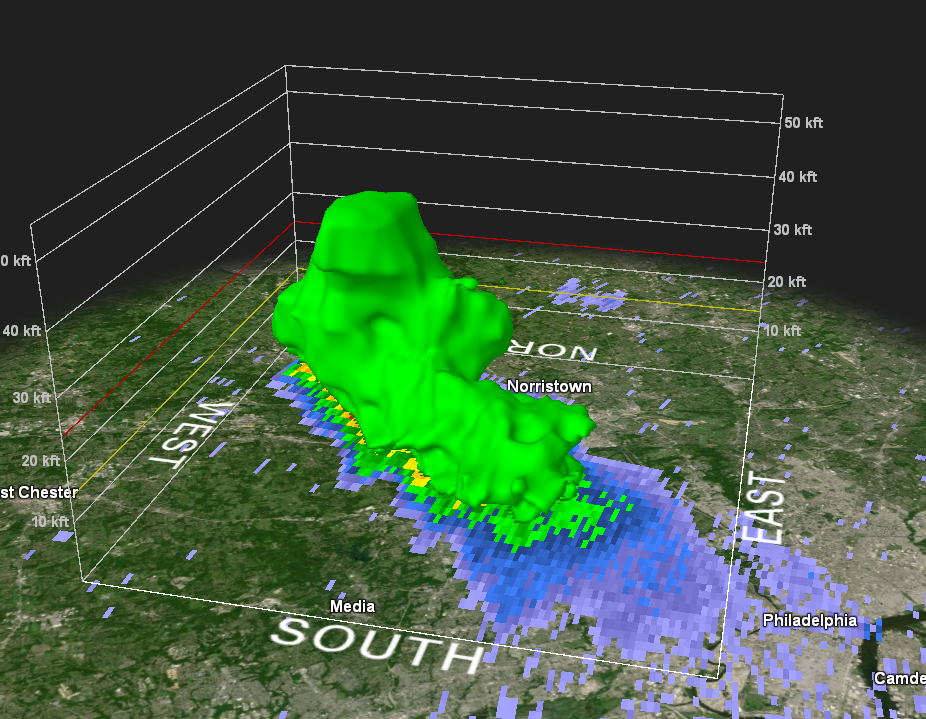
-
E PA/NJ/DE Spring 2022 OBS Thread
Hurricane Agnes replied to Hurricane Agnes's topic in Philadelphia Region
I can see the front of it looking to the WSW. My temp is down to 75 with dp 66. Convection is firing up (at least the lightning detector is picking it up).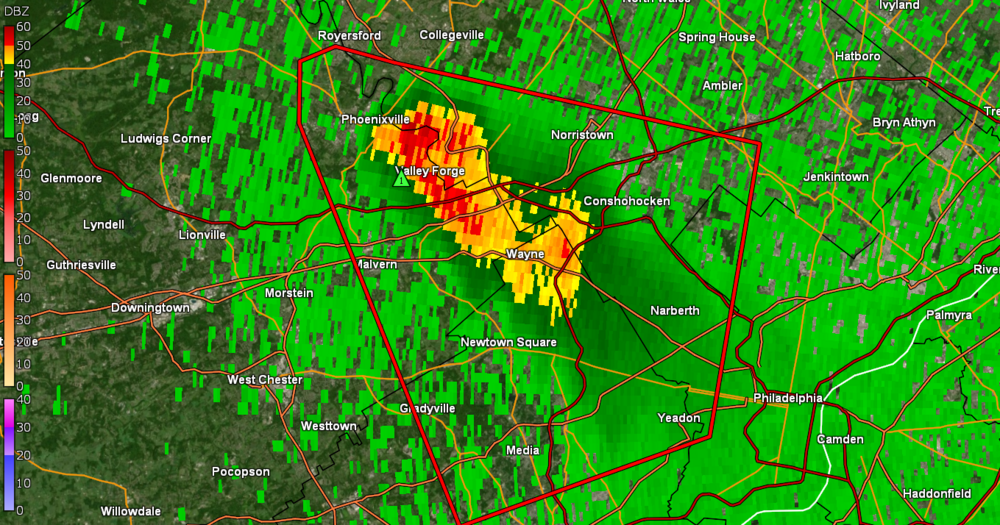
-
E PA/NJ/DE Spring 2022 OBS Thread
Hurricane Agnes replied to Hurricane Agnes's topic in Philadelphia Region
STS issuing right now for us!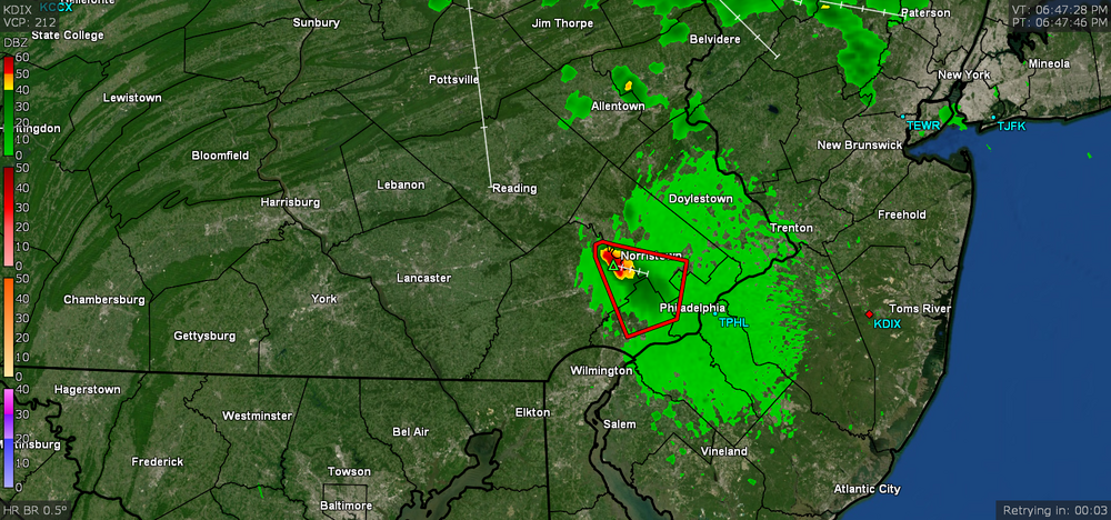
-
E PA/NJ/DE Spring 2022 OBS Thread
Hurricane Agnes replied to Hurricane Agnes's topic in Philadelphia Region
I have been periodically looking at the radar as little cells form, expand as they move to the east, and then fizzle. Most of the heaviest action has been in NE PA, SE NY, and NW NJ on either side of the PA/NY/NJ border. -
E PA/NJ/DE Spring 2022 OBS Thread
Hurricane Agnes replied to Hurricane Agnes's topic in Philadelphia Region
Well I squeezed out one more degree to get to a final high of 84 today around 5:20 pm. It's currently partly sunny and 80 with a dp of 69. -
E PA/NJ/DE Spring 2022 OBS Thread
Hurricane Agnes replied to Hurricane Agnes's topic in Philadelphia Region
Norman has a Severe Thunderstorm Watch for our Lehigh Valley and North central Jersey parts of the CWA - So far my high has reached 83 for the day and it's currently partly sunny, clouding up a bit, and 83, with dp 68, so not as comfortable as it was earlier this morning. -
E PA/NJ/DE Spring 2022 OBS Thread
Hurricane Agnes replied to Hurricane Agnes's topic in Philadelphia Region
SPC SWDY2 has the southern parts of the CWA in a "Slight Risk" - I had noticed early this morning how the radar was fired up around the NYC area so I expect that is where the backdoor front was at the time. I suppose wherever it wobbles/settles will be where the convection will be. In any case, am still sitting at 68 and sunny with dp 62. -
E PA/NJ/DE Spring 2022 OBS Thread
Hurricane Agnes replied to Hurricane Agnes's topic in Philadelphia Region
I could tell when the backdoor started pushing through here because when I came down this morning just after 4 am, the temp was around 76 and was slowly creeping down... But then by ~6:30 am, it had suddenly dropped down to 67 (my low so far). In any case, it's currently sunny and 68 with dp 62. -
E PA/NJ/DE Spring 2022 OBS Thread
Hurricane Agnes replied to Hurricane Agnes's topic in Philadelphia Region
I remember some classrooms might roll in one of those gigantic metal pedestal fans. Had to be close to 36" diameter. Well 95 was my high for the day and it's currently down to 84 with dp back up again to 67. There was one RER for today for Reading, which tied its record high today (the Text Products page is supposed to move to a new site 6/14/22 so right now, the current one has some stuff in odd locations like the below) - -
E PA/NJ/DE Spring 2022 OBS Thread
Hurricane Agnes replied to Hurricane Agnes's topic in Philadelphia Region
Oh I know that feeling. When I was in public school here we just pulled the bottom sashes of the windows all the way up, fought over who got to use the window pole to pull down the top sash, turned off the lights, and put our heads down on our desks while the bees flew around the room (no screens). Still haven't gone higher than 95 here (yet) although it continues to bop between 94 and 95 and is currently 94 w/dp now down to 61 (still a bit uncomfortable but better than the mid-upper 60s earlier this morning). -
E PA/NJ/DE Spring 2022 OBS Thread
Hurricane Agnes replied to Hurricane Agnes's topic in Philadelphia Region
Briefly tapped 95 at 2:46 pm and currently at 94 with dp down a bit to 64. Heard on KYW that they let the Philly schools out early due to the heat (and the persistent lack of AC in the old piece of junk buildings). -
E PA/NJ/DE Spring 2022 OBS Thread
Hurricane Agnes replied to Hurricane Agnes's topic in Philadelphia Region
Now up to 92 here at 1 pm with dp 68. Will see if I actually make it to the mid-90s (definitely not upper 90s though). -
E PA/NJ/DE Spring 2022 OBS Thread
Hurricane Agnes replied to Hurricane Agnes's topic in Philadelphia Region
And boom! 11:09 am it hit 90 and at post time it's a cloudless 91, with dp 68. My station's "Feels Like" is 94. -
E PA/NJ/DE Spring 2022 OBS Thread
Hurricane Agnes replied to Hurricane Agnes's topic in Philadelphia Region
Now up to 81 at post time (8:33 am) with dp 69. If those dews don't mix out today, then we may get close to heat advisory criteria. -
E PA/NJ/DE Spring 2022 OBS Thread
Hurricane Agnes replied to Hurricane Agnes's topic in Philadelphia Region
And we're off to the races this morning. Bottomed out at 70 just before 5:30 am. Am now up to 74 and sunny with dp 68. -
E PA/NJ/DE Spring 2022 OBS Thread
Hurricane Agnes replied to Hurricane Agnes's topic in Philadelphia Region
Didn't quite make it to 90 today but got close - 89 at 3:25 pm. It's currently sunny and 86 with dp 68 (ack). -
E PA/NJ/DE Spring 2022 OBS Thread
Hurricane Agnes replied to Hurricane Agnes's topic in Philadelphia Region
Made it up to 81 as a high here yesterday (was at my Wyndmoor sister's house for a bbq). Turned out to be a nice day - not too hot and not humid. Had a low of 62 this morning and am currently mostly sunny and up to 78 with dp now getting closer to that uncomfortable range already at 67. -
E PA/NJ/DE Spring 2022 OBS Thread
Hurricane Agnes replied to Hurricane Agnes's topic in Philadelphia Region
Bottomed out at 60 this morning and turning out to be a nice day with lower humidity. Currently mostly sunny and 75, with some scattered cumulus and dp 57. -
E PA/NJ/DE Spring 2022 OBS Thread
Hurricane Agnes replied to Hurricane Agnes's topic in Philadelphia Region
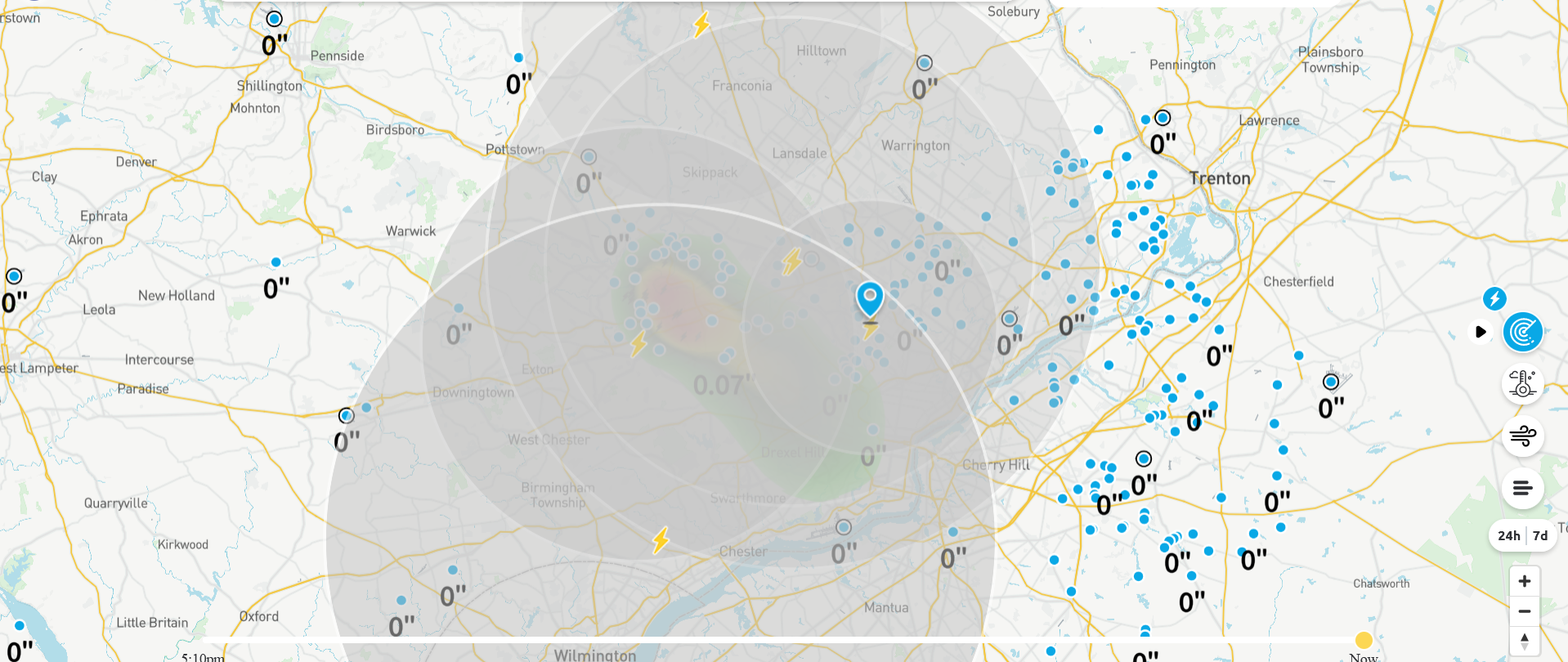
I had a passing blip blow over me and now have 0.07" in the bucket at post time (event total of 1.33"). Currently drizzling and 68 with dp 64. -
E PA/NJ/DE Spring 2022 OBS Thread
Hurricane Agnes replied to Hurricane Agnes's topic in Philadelphia Region
There are some weird puffy cumulus clouds out there today - at least in my neck of the woods. It's still sunny but I expect it's a result of CAA and the storms to the north and east. I had assumed that Sunday would be the better of the two weekend days in any case. You are on the southern fringe of all those storms. Temp is up to 75 here with dp 65 (low was 64 this morning). -
E PA/NJ/DE Spring 2022 OBS Thread
Hurricane Agnes replied to Hurricane Agnes's topic in Philadelphia Region
That was a nice parting segment for him. He was one of the rare "locally born and raised" TV mets who eventually managed to "return home" and remain here for a good chunk of his career before retiring. That's the one thing about mets - especially broadcast - where you pretty much have to be resigned to go anywhere in the U.S. for a job. Here is a link to his recognition in the Broadcast Pioneers of Philadelphia (inducted back in 2010) - https://www.broadcastpioneers.com/bp3/glennschwartz.html And Bolaris was just a bizarre clown. Looks like the latest batch of precip on the radar has been breaking up and I'll probably be missed or sideswiped but will see. -
E PA/NJ/DE Spring 2022 OBS Thread
Hurricane Agnes replied to Hurricane Agnes's topic in Philadelphia Region
Ended up getting another 0.76 of rain between 11 pm and midnight from the cluster that came through overnight giving me a total of 1.26" yesterday. Had another 0.01" just after midnight for a total of 1.27" 2-day total. That overnight pass triggered all kinds of convection although didn't hear anything and may have been more cloud-to-cloud. Current temp is 64 with dp 64 and watching to see what the next batch does.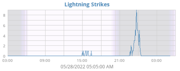
-
E PA/NJ/DE Spring 2022 OBS Thread
Hurricane Agnes replied to Hurricane Agnes's topic in Philadelphia Region
Back edge of the precipitation shield is approaching MBY and so far have 0.50" total for the day (so far), with 0.49" coming from that line. There's more stuff sitting back over OH so we may see more rain/T-storms overnight and into tomorrow morning depending on how fast that little complex moves. Currently overcast but clearing and 68 with dp 68.