

Hurricane Agnes
-
Posts
9,344 -
Joined
Content Type
Profiles
Blogs
Forums
American Weather
Media Demo
Store
Gallery
Everything posted by Hurricane Agnes
-
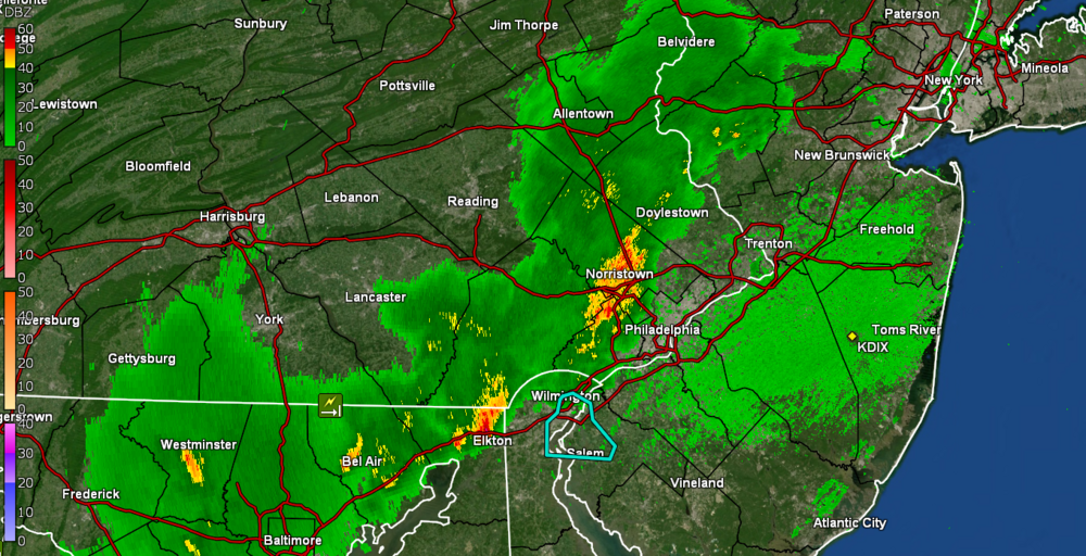
And RAIN! (no convection with that yet)
-
Had a low of 58 this morning and so far it went up to 74 when the sun finally came out later this morning. But right now, it looks like armageddon outside with the sudden overcast and this on my doorstep! Will see if it can hold together for the couple miles that it is from me.
-
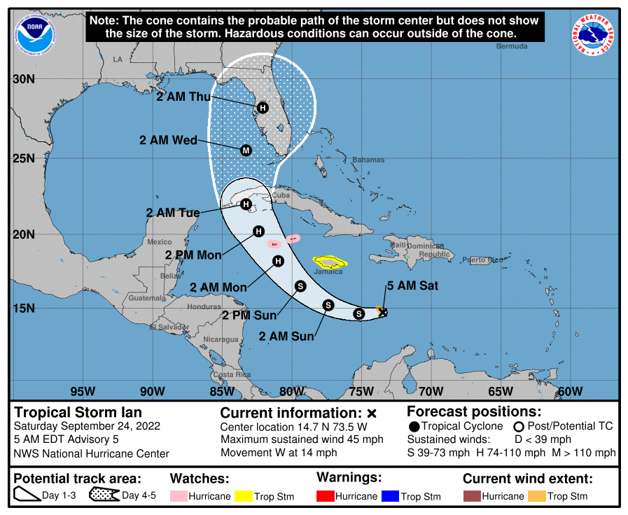
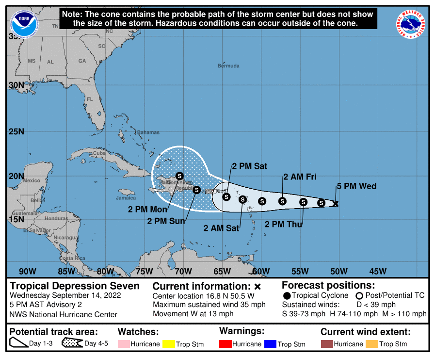
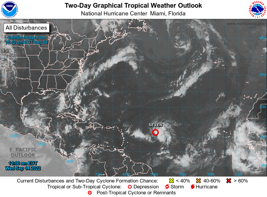
Had a final high of 64 yesterday and am sitting near my low for the morning of 46, with the last time it has been that IMBY, was back on May 9. Haven't completely decoupled and gone calm here but am close. Currently 47 with some scattered clouds and dp 39. Keeping an eye on TS Ian that recently formed (TD-9) and is aimed at FL.
-
Finally bottomed out at 51 this morning and it's currently 52 and partly sunny with dp below 40 for the first time in a long time, at 39!
- 852 replies
-
- 1
-

-
- hurricane
- tropical storm
- (and 1 more)
-
Some Frost Advisories lofted in a couple southern NY state counties across from NE PA. Mother Nature giving the signal to "get ready".
- 852 replies
-
- 1
-
-
- hurricane
- tropical storm
- (and 1 more)
-
I know you are ecstatic! Did finish with a high of 79 yesterday and right now have some scattered clouds around and temp here IMBY is 52, with the dp 43.
-
After several hours of virga, finally getting some light rain with the frontal passage. Temp literally dropped from 70 down to 63. Have 0.06" in the bucket at post time. Dew point is 60.
-
Got up to 81 as a high yesterday after a low of 61. This morning was like soup with a low of 68 ahead of the cold front. Currently clouding over quickly ad 78 with dp 70.
-
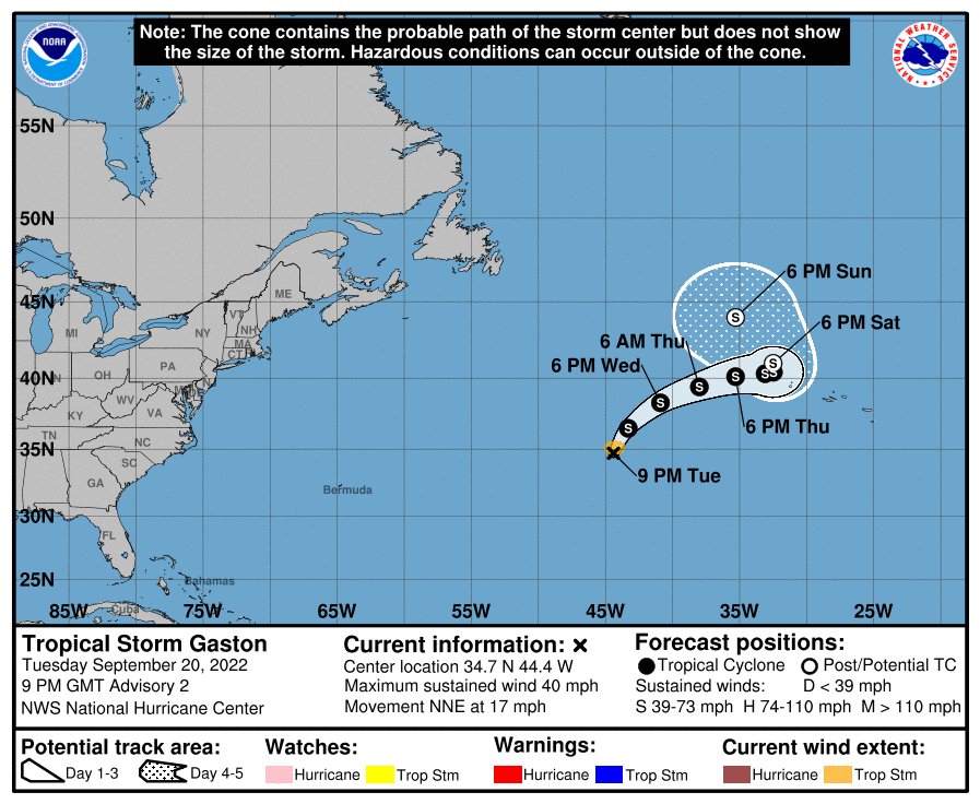
Gaston is a long way away! Didn't make it to 80 here today (had a high just short, at 79). The dews at least dropped into the 50s. It's currently partly cloudy about 10 minutes from sunset, and 76 with dp 59.
- 852 replies
-
- 1
-

-
- hurricane
- tropical storm
- (and 1 more)
-
Got a parting shot of more drops enough to finally tip the bucket for 0.01". Sun out and humidity up with temp still 74 but dp now 69.
- 852 replies
-
- 1
-
-
- hurricane
- tropical storm
- (and 1 more)
-
Topped out at 82 yesterday and 86 today before it clouded over. Had a low this morning of 64. Have gotten about 80 drops which was enough to wet the walk but otherwise not enough to even be measurable. I guess I'll take the wetted leaves. LOL Currently overcast with mostly virga and random splats, and temp at 74, with dp 68.
-
Made it up to 80 as a high yesterday and had a "warmer" low this morning of 62, with what I expect was some stratus that has mostly cleared now. There's currently a thin and hazy deck of cirrus that the sun is penetrating and it's 66 with dp 65.
-
My high yesterday was 75 and I had a "warmer" low this morning of 60. It's currently already past yesterday's high and is mostly sunny and 78 with scattered cumulus and a dp of 63.
-
Made it up to 73 as a high yesterday after a 67 low. The dews yesterday had dropped down into the upper 40s to boot. This morning's 53 low was the lowest here since June 6. It's currently mostly sunny and 69 with dp 54.
-
Maxed out at 78 and the dews have been staying in the low 60s much of the day. Currently clear and 74 with dp 61.
-
Maybe for this guy that formed today. Otherwise I bottomed out at 59 this morning and it's currently a sunny 77 and all blue sky, with dp 60.
- 852 replies
-
- 1
-
-
- hurricane
- tropical storm
- (and 1 more)
-
There was some light rain last night enough to tip the bucket for 0.01" but the bulk of overnight rain came between 1 - 3 am giving me an additional 0.82". That has now brought my September total (usually one of our drier months absent any tropical cyclones/remnants) to 5.55" IMBY. Currently an overcast and misty 71 with dp 71.
-
Jeb just wants to go a-walking! As an obs, I ended up with 0.55" of rain yesterday and my "low" has been 70 this morning, where it has been hovering around that as a floor for some time, + a few degrees and back as the temp wobbles. Didn't have any fog here but some low stratus that initially started to break up but then it clouded over again. It's currently 72 with dp 71 and had the steamy windows this morning.
-
Nawwww... not lambasting you. Just cracking up at this - I know it can be hard to find overall long-term forecasters who regularly post blogs without the hype, so I often just look for those who focus on certain weather events (like Levi Cowan when tropical cyclones are in the area and he does his video discussions on tropical tidbits - https://www.tropicaltidbits.com/) or for winter, I'll often check here - https://www.severe-weather.eu/frontpage/welcome-to-severe-weather-europe/ where they are monitoring for SSWEs that foretell PV intrusion into the CONUS. They had their first discussion post on that here - https://www.severe-weather.eu/global-weather/polar-vortex-cooling-forecast-winter-2022-2023-influence-united-states-europe-fa/ Their 2022/2023 initial forecast (using 3 different models including the EC) - https://www.severe-weather.eu/long-range-2/winter-forecast-2022-2023-season-first-look-united-states-europe-fa/ Their mention of NOAA's current expectation with this 3-pete La Nina -
-
He's gone complete loon so point taken. And if you act now (and use the special code), you can get the Ya'll o meter for 10% off!!!!!!
- 852 replies
-
- 1
-
-
- hurricane
- tropical storm
- (and 1 more)
-
I didn't even bother looking at any of the rest of his stuff (especially since he was hawking his "Ya'll o Meter" snow measuring stick). I take heart that he at least admits that mets are in a rare profession where they can "get it wrong and still keep their jobs".
-
The image still for that video has that map with the "4ft of snow" area carved out with us in it but nowhere in the actual video does it have that for here. He had something along the line of 2ft - 3ft, which is our usual average/range anyway.
-
LOL The ENSO patterns seem to shift based on the strength of the El Nino or La Nina too and it will also depend on the PV and what manages to ooze down here out of the north. I think he did give a reasonable call though. I made it up to 73 today as a high, just after 9 am before the rain moved in, and so far have 0.54" in the bucket from today's round. It's currently an overcast and misty 71 with dp 70 and yes, I also had to give up and turn the AC on due to the soup (the fan just wasn't doing it).
-
Have been getting light rain with 0.11 in the bucket at post time. Temp is 70 with dp 69.
-
Made it up to 81 as a high yesterday and bottomed out at 68 this morning. You can feel the humidity now with the dp rise. It's currently 72 and overcast with some occasional droplets falling from the sky, and with dp 68.
