Hurricane Agnes
-
Posts
9,263 -
Joined
Content Type
Profiles
Blogs
Forums
American Weather
Media Demo
Store
Gallery
Everything posted by Hurricane Agnes
-
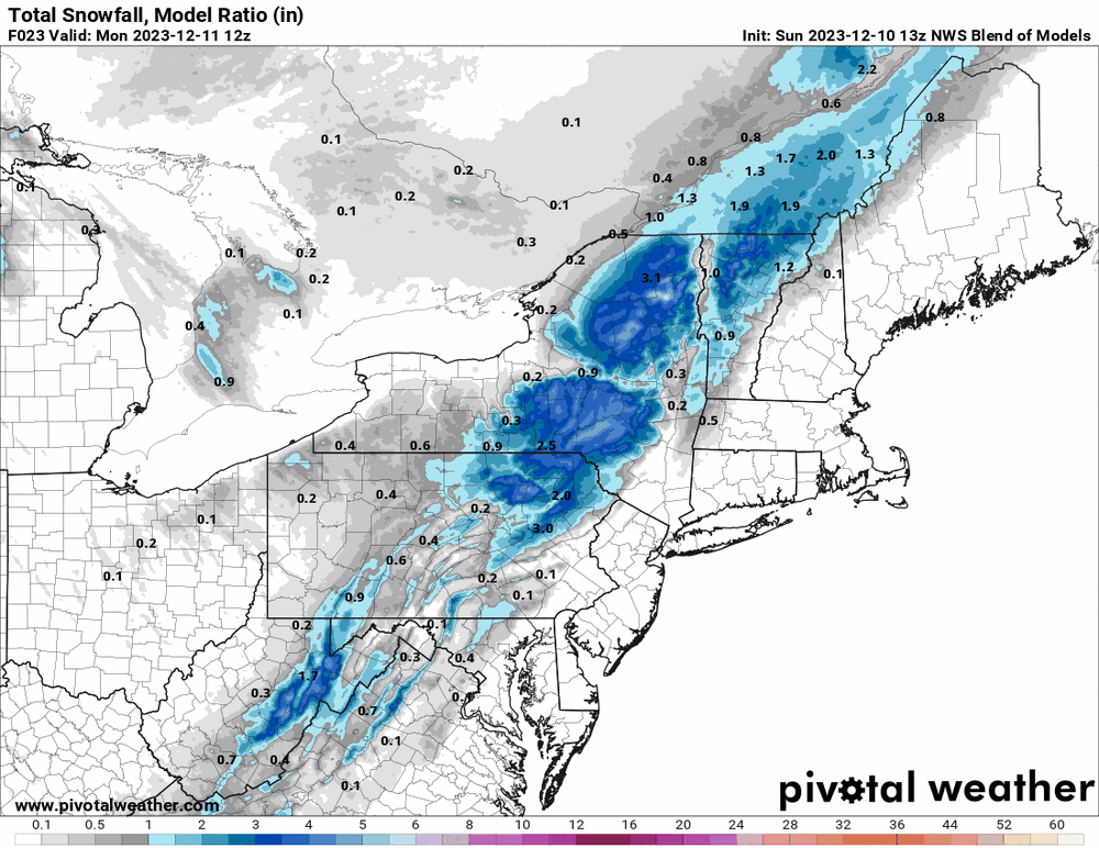
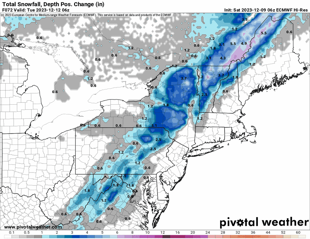
E PA/NJ/DE Winter 2023-2024 OBS/Discussion
Hurricane Agnes replied to The Iceman's topic in Philadelphia Region
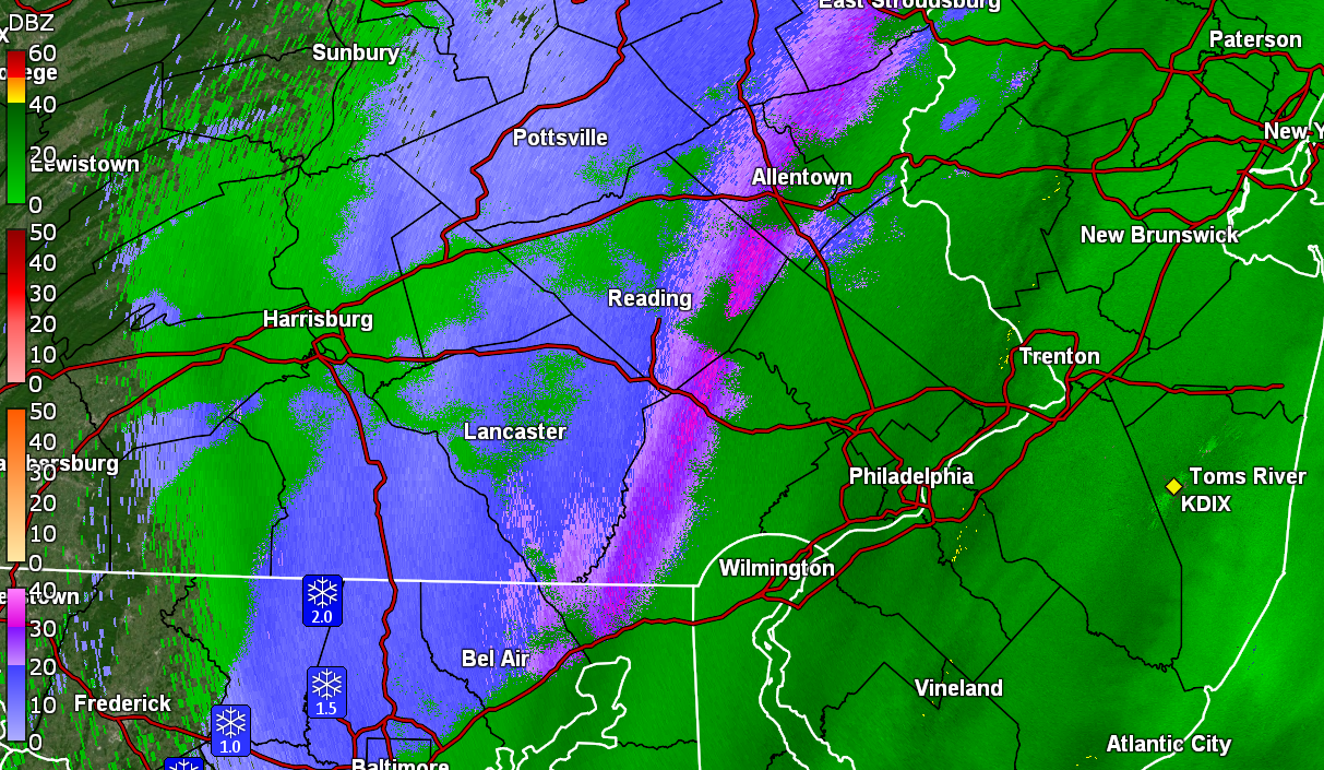
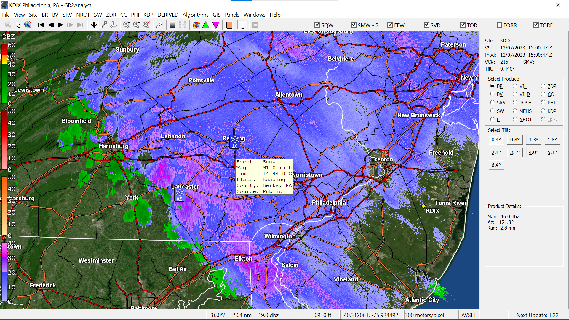
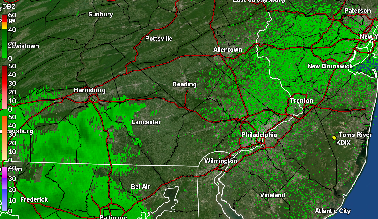
Still have a rain/snow mix here blowing out of the NW, although the flakes aren't the pancakes from earlier. Am up to 0.53" for the day so far (2.48" 2-day rain total). Flooding has Lincoln Dr. closed and the Wissahickon Creek is definitely out of its banks! Currently 35 with dp 34 with light rain/snow mix.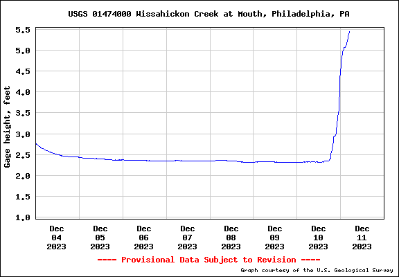
-
E PA/NJ/DE Winter 2023-2024 OBS/Discussion
Hurricane Agnes replied to The Iceman's topic in Philadelphia Region
Can confirm fatties in the air here and KYW traffic reporter mentioned lower visibility on the turnpike to the west and also up north in the LV. Currently 35 with a light rain/snow mix (now at 0.47" for the day) and dp 35.
-
E PA/NJ/DE Winter 2023-2024 OBS/Discussion
Hurricane Agnes replied to The Iceman's topic in Philadelphia Region
With the non-diurnal temp swings yesterday, my "low" for yesterday ended up being just before midnight with the cold front having moved through, and after a high of 61. Ended up with 1.95" of rain yesterday plus an additional 0.43" (so far) today, for a 2-day total of 2.38" of rain. Currently light rain and 37 with dp 37. -
E PA/NJ/DE Winter 2023-2024 OBS/Discussion
Hurricane Agnes replied to The Iceman's topic in Philadelphia Region
Just hit the 1.00" mark with about 1/3rd" rates. Temp holding at 60 with dp 60. -
E PA/NJ/DE Winter 2023-2024 OBS/Discussion
Hurricane Agnes replied to The Iceman's topic in Philadelphia Region
Heavier rain band has been backing in from the SE with a SW flow.. Now up to 0.58" with >1.3"/hr rates. Temp has crept up to 61 with dp 61. -
E PA/NJ/DE Winter 2023-2024 OBS/Discussion
Hurricane Agnes replied to The Iceman's topic in Philadelphia Region
The early rain shield has big gaps and I'm currently at 0.17" (just ticked over since it started raining again after a lull). Currently have light rain and it's 60 with dp 59. -
E PA/NJ/DE Winter 2023-2024 OBS/Discussion
Hurricane Agnes replied to The Iceman's topic in Philadelphia Region
Finally got a bucket tip to 0.01" as the rain shield moves closer. Still 59 with dp now 59 and overcast. -
E PA/NJ/DE Winter 2023-2024 OBS/Discussion
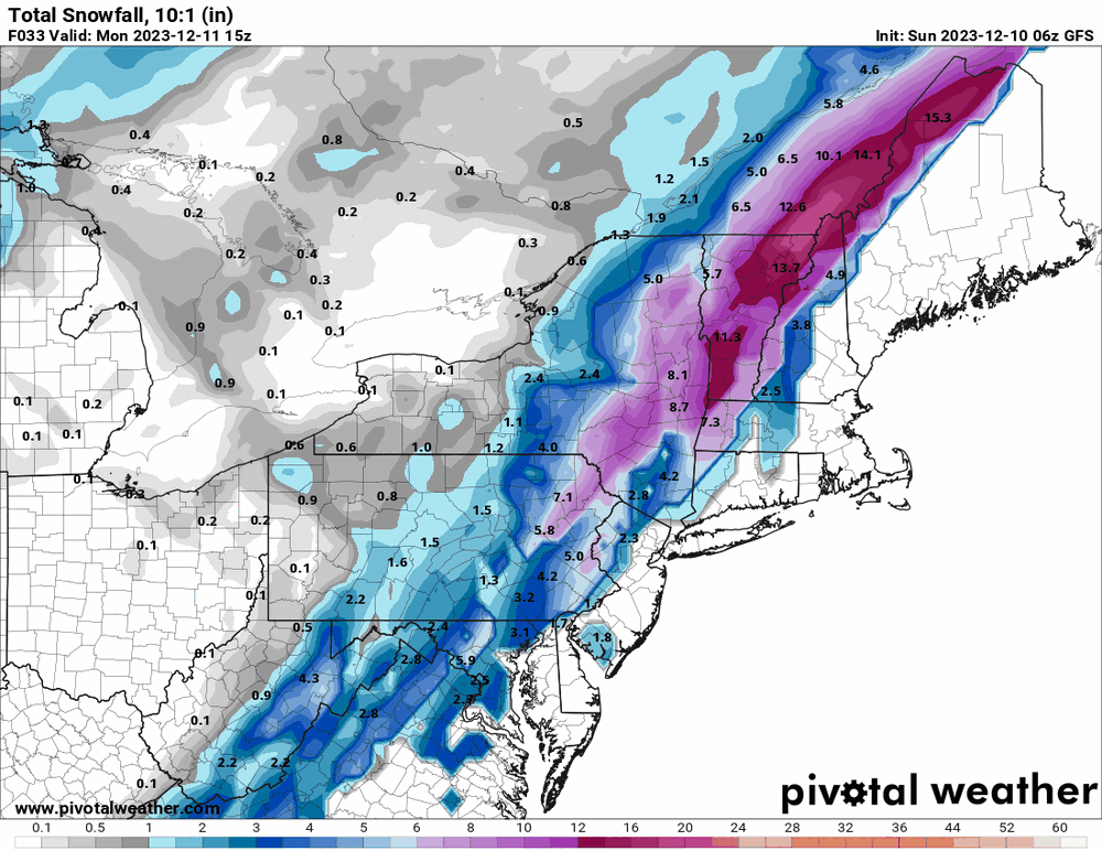
Hurricane Agnes replied to The Iceman's topic in Philadelphia Region
12z GFS drier than the NAM in the southeast. ETA - the latest NBM is going with the drier (more rainy/less snowy) solution for the southeast. Currently wet (non-measurable so far) and 59 with dp 58.
-
E PA/NJ/DE Winter 2023-2024 OBS/Discussion
Hurricane Agnes replied to The Iceman's topic in Philadelphia Region
12z 3k NAM just rolled out and throws a bit more to the east. ETA, I'm now at 60 with dp 57.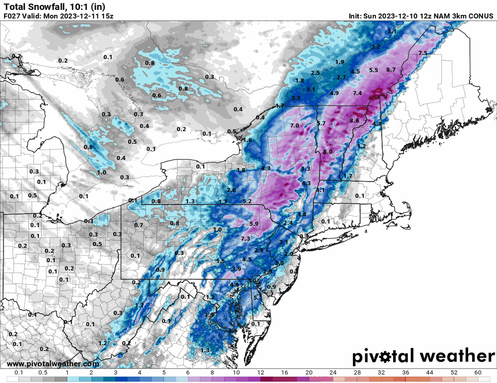
-
E PA/NJ/DE Winter 2023-2024 OBS/Discussion
Hurricane Agnes replied to The Iceman's topic in Philadelphia Region
Temps have been rising overnight so my "low" was 47 at midnight (assuming the cold front doesn't come through until early tomorrow morning). It's currently 57 with dp 55. Looks like the 6z 3k NAM un-NAM'd itself and threw most of the precip to the N/W with a little to the E/S. ETA 6z GFS throws a little more to the east.
-
E PA/NJ/DE Winter 2023-2024 OBS/Discussion
Hurricane Agnes replied to The Iceman's topic in Philadelphia Region
Bottomed out at 37 this morning and the fog/low stratus was thick but much of that has lifted now although it is still misty and overcast. Currently 44 with dp 44. 6z hi-res Euro does throw a changeover into the mix for tomorrow. I noticed what was originally a more inland low has been pushed east and at least according to the Euro, may bomb out when it gets off the coast of NE. However it looks like the accums would still be N/W with the colder air.
-
E PA/NJ/DE Winter 2023-2024 OBS/Discussion
Hurricane Agnes replied to The Iceman's topic in Philadelphia Region
Well this got lofted (with a NOAA weather radio alert - hadn't heard one of those in awhile! ) Made it up to 39 as a high yesterday and bottomed out at 30 this morning. Have probably topped out now at 51 and it's currently 49 and partly sunny, with a deck of high clouds, and dp 37. -
E PA/NJ/DE Winter 2023-2024 OBS/Discussion
Hurricane Agnes replied to The Iceman's topic in Philadelphia Region
Spotter in Reading reported 1". So far no stickage here with SN-, temp 34, and dp 31. Walks and streets are wet.
-
E PA/NJ/DE Winter 2023-2024 OBS/Discussion
Hurricane Agnes replied to The Iceman's topic in Philadelphia Region
I ended up hitting 40 for a high yesterday with on and off flakes that didn't stick. Bottomed out at 30 this morning and currently have more flakes with a temp of 32 and dp 26. -
E PA/NJ/DE Winter 2023-2024 OBS/Discussion
Hurricane Agnes replied to The Iceman's topic in Philadelphia Region
My sis in Upper Darby texted that she is getting some down there. I see it on radar although haven't seen any reach the ground here yet (unless I missed an earlier round). Made it up to 44 yesterday and so far bottomed out at 36 this morning. Currently overcast and 37 with dp 30. -
E PA/NJ/DE Winter 2023-2024 OBS/Discussion
Hurricane Agnes replied to The Iceman's topic in Philadelphia Region
I think there are at least 4 over-60s posting regularly here so join the club! At this point due to the persistent temp rises in the oceans, the past analog years are going to be more and more "out of date" to use for predicting the current/future environment. If anything, you'd probably do better to shift the seasons by a couple months where "winter" is fall-like and "spring" is winter-like (we have been walloped in March for example - ocean temps slowly coming off mins and plenty of moisture). Since you mention 1993, so far to date, the last time KPHL went below 0F was in 1994. We had a dusting of snow down here on 11/28. As some catch-up OBS, Sun/Mon. highs were both 51 with a Monday low of 37, and a low this morning of 33. It's currently a partly sunny 39 through a deck of cirrus, with a dp of 34. -
E PA/NJ/DE Winter 2023-2024 OBS/Discussion
Hurricane Agnes replied to The Iceman's topic in Philadelphia Region
Bottomed out at 48 this morning, with the temps pretty much staying in that range overnight. Measurable rain started around midnight and have 0.75" in the bucket as the rain has tapered off. It's currently overcast and misty with temp 51 and dp 51. -
E PA/NJ/DE Winter 2023-2024 OBS/Discussion
Hurricane Agnes replied to The Iceman's topic in Philadelphia Region
Well the critters supposedly become lethargic when the temps go below 60... But if they have a nest underground or in an attic or wall, then they are... well... busy as bees! Watching the incoming precip... Will probably take time to get here though. Fog is denser here now, less than 100 yards and closing in, and that is with some occasional breezes. Temp still hanging at 49 with dp 49.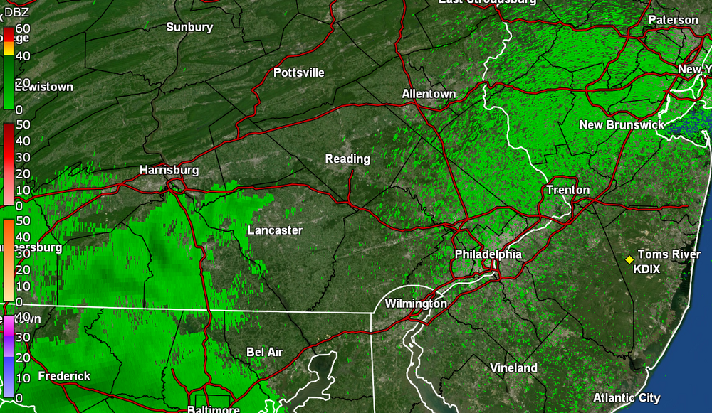
-
E PA/NJ/DE Winter 2023-2024 OBS/Discussion
Hurricane Agnes replied to The Iceman's topic in Philadelphia Region
Socked in here now. Vis. < 1/10th of a mile. Temp is 49 with dp 48. -
E PA/NJ/DE Winter 2023-2024 OBS/Discussion
Hurricane Agnes replied to The Iceman's topic in Philadelphia Region
Fog had finally lifted later this morning and the sun popped out by noon. Temp is up to 57 with some high clouds rolling in now and dp 53. -
E PA/NJ/DE Winter 2023-2024 OBS/Discussion
Hurricane Agnes replied to The Iceman's topic in Philadelphia Region
Many of them manage to nest inside structures (homes, buildings, etc). Possibly due to this (MJO in phase 3 w/blue GFS and green GEFS progs) -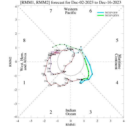
-
E PA/NJ/DE Winter 2023-2024 OBS/Discussion
Hurricane Agnes replied to The Iceman's topic in Philadelphia Region
The last day of November started with a low of 26 and finished with a high of 51. Made up some of the rain deficit from October with 4.33" for the month of November. Yesterday didn't get as warm as I expected, only reaching a high of 46 after a low of 32, with 0.46" of rain. This morning the fog/low stratus is thick, with vis. < 1/4 mile where I am (although the city was left out of the dense fog advisory). Temp is 45 with dp 45. -
E PA/NJ/DE Fall 2023 OBS/Discussion Thread
Hurricane Agnes replied to Rtd208's topic in Philadelphia Region
Well I bottomed out at 24 for a low this morning and only made it up to 37 for a high. Since a breeze kept up overnight, it probably didn't make for good radiational cooling. The arctic air did send my dews down as low as 14 earlier but the dp has ticked up and I'm currently 32 with dp 18. -
E PA/NJ/DE Fall 2023 OBS/Discussion Thread
Hurricane Agnes replied to Rtd208's topic in Philadelphia Region
I think some of the pink passed over your area. That arctic air means business. Currently 36 but the dewpoint is down to 17 and has been continuing to slowly fall. The humidifier is starting to struggle.
-
E PA/NJ/DE Fall 2023 OBS/Discussion Thread
Hurricane Agnes replied to Rtd208's topic in Philadelphia Region
Well that round is done and sun is back out. Got a trace/dusting (0.1") of what appeared to be rimed flakes and possibly graupel. Temp is 31 with dp 28.