Hurricane Agnes
-
Posts
9,343 -
Joined
Content Type
Profiles
Blogs
Forums
American Weather
Media Demo
Store
Gallery
Everything posted by Hurricane Agnes
-
E PA/NJ/DE Winter 2023-2024 OBS/Discussion
Hurricane Agnes replied to The Iceman's topic in Philadelphia Region
The Governor officially named Punxsutawney Phil the "official" PA State Meteorologist this morning. So far have 0.12" in the bucket today. -
E PA/NJ/DE Winter 2023-2024 OBS/Discussion
Hurricane Agnes replied to The Iceman's topic in Philadelphia Region
But there are still plenty of floodlights out there. Looks like Phil cancelled winter. -
E PA/NJ/DE Winter 2023-2024 OBS/Discussion
Hurricane Agnes replied to The Iceman's topic in Philadelphia Region
It may get stuck in the mud. When I was out yesterday running errands I did see a few surviving plowed mounds still occupying space in the store parking lots, albeit pretty much completely dirt covered. Well the first day of February started off with a low of 29 (with folks out there scraping frost off their car windshields) and made it to a high of 47. I finished January with 7.53" of liquid (although it was missing some rain when snow/ice-clogged with that storm #1 in mid Jan.). I did see the sun much of the day today but then as progged, it clouded over. It's currently 45 with dp 37. -
E PA/NJ/DE Winter 2023-2024 OBS/Discussion
Hurricane Agnes replied to The Iceman's topic in Philadelphia Region
Made it up to 37 yesterday after a low of 33 and had noticed the sidewalk was wet with some non-measurable precip yesterday evening (didn't see flakes at the time). Overnight registered 0.01" of liquid although again, am not sure if any of it was from flakes, light rain/drizzle, or a mix. The temp stayed above freezing overnight regardless. Currently a damp and misty 35 with dp 33. -
E PA/NJ/DE Winter 2023-2024 OBS/Discussion
Hurricane Agnes replied to The Iceman's topic in Philadelphia Region
Kamu's squirrels are looking for their mound and traveled up there to find one! The sun did manage to pop out earlier this morning but that didn't last long. It's currently 40 and overcast with dp 32. -
E PA/NJ/DE Winter 2023-2024 OBS/Discussion
Hurricane Agnes replied to The Iceman's topic in Philadelphia Region
The on and off drizzle/light rain rounds continued yesterday evening after my last report and I finished up with 1.07" yesterday. The precip. kept on coming overnight with 0.04" in the bucket this morning, resulting in a 5-day total of 1.64". Currently mostly cloudy and 38 with dp 35. -
E PA/NJ/DE Winter 2023-2024 OBS/Discussion
Hurricane Agnes replied to The Iceman's topic in Philadelphia Region
Bottomed out at 39 this morning and haven't moved much today, with a high so far of 42. The initial round of the heavy rain that began sometime after 1 am, netted me 0.93" before a pause. A lighter round ensued mid-morning with an additional 0.07" (so far) for a total of 1.00" on the nose at post time. Currently a misty 40 with dp 40. ETA to note that I have recorded 7.41" of liquid for the month (so far) although some of that is missing rain data during the transitions from snow/sleet to rain for the 1/15 - 1/16/24 storm that didn't make it through a snow/ice-clogged gauge and also includes delayed snow melt from the gauge. -
E PA/NJ/DE Winter 2023-2024 OBS/Discussion
Hurricane Agnes replied to The Iceman's topic in Philadelphia Region
Ended up with a low of 41 this morning and a high of 49. And yes, that odd yellow orb in the sky did make an appearance thanks to breaks in the clouds. Had some leftover misty stuff deposit 0.01" in the bucket early this morning, and with 0.26" the previous 2 days, I ended up with 0.53" for a 3-day total. Currently partly cloudy and 46 with dp 41. -
E PA/NJ/DE Winter 2023-2024 OBS/Discussion
Hurricane Agnes replied to The Iceman's topic in Philadelphia Region
Bottomed out at 43 this morning and made it up to 51 for a high. It's currently a pea soup-thick foggy 49 (vis. < 1/10th of a mile) with dp 48. -
E PA/NJ/DE Winter 2023-2024 OBS/Discussion
Hurricane Agnes replied to The Iceman's topic in Philadelphia Region
The couple nights that stayed above freezing pretty much knocked everything on the grass and streets completely out. The giant plowed mounds in the supermarket lots are still there though. Made it up to 44 for a high yesterday, bottomed out at 43 this morning, and ended up at 53 for a high today. The fog where I am was much greater yesterday than today although where my sis is in Wyndmoor, they had much more today (more open areas still had snow cover there). Was expecting more rain by now (had 0.03" yesterday and 0.21" today so far), but will see what might bubble up overnight. Currently a misty 51 with dp 51. -
E PA/NJ/DE Winter 2023-2024 OBS/Discussion
Hurricane Agnes replied to The Iceman's topic in Philadelphia Region
Ended up hitting 36 for a high today so had lots of slushy shoveled/plowed mounds that will freeze solid tonight. Currently 30 with dp 20. -
E PA/NJ/DE Winter 2023-2024 OBS/Discussion
Hurricane Agnes replied to The Iceman's topic in Philadelphia Region
12z Canadian has the High oozing down just after the precipitation has mostly moved OTS.
-
E PA/NJ/DE Winter 2023-2024 OBS/Discussion
Hurricane Agnes replied to The Iceman's topic in Philadelphia Region
Looks like the suggestion was that a Canadian High was going to ooze down over NE and chill things as the Low passes off the coast. Nailing that this far out (for GFS) might be dodgy though.
-
E PA/NJ/DE Winter 2023-2024 OBS/Discussion
Hurricane Agnes replied to The Iceman's topic in Philadelphia Region
Wanted to wait until after sunrise this morning to confirm but my low this morning was 20. And although the winds relaxed after about 6 pm last night, they never went calm, and there were puffs of a breeze on and off all night, so the ideal radiational cooling wasn't in effect. Currently mostly sunny and 23 with dp 16. -
E PA/NJ/DE Winter 2023-2024 OBS/Discussion
Hurricane Agnes replied to The Iceman's topic in Philadelphia Region
Bottomed out at 20 this morning and made it up to just under freezing with a high of 31. The wind was blowing a lot of the powder off the roofs in the area in any case. I also noticed that some time after noon yesterday, my station's anemometer and vane managed to free themselves from their frozen encasement and were moving again. Currently clear and 29 with dp 14 and I expect the radiational cooling will be in full effect tonight. -
January 19, 2024 Powder Snow Event
Hurricane Agnes replied to Ralph Wiggum's topic in Philadelphia Region
OMG it's been a LONG time since we've seen the epic snow pile at your spot! As powdery stuff, six on one side says it would go quickly and a dozen on the other says if there is some rain in there with melting and refreezing, the potential for glacier creation would be there to help build a solid foundation. So far today (and probably the final) my "high" for the day was 23 at midnight as I got no higher than 22 during the daytime hours. It's currently partly sunny but with a high cloud deck moving in, and 22 with dp 9. -
E PA/NJ/DE Winter 2023-2024 OBS/Discussion
Hurricane Agnes replied to The Iceman's topic in Philadelphia Region
Bottomed out at 17 this morning and did the initial car clearing. Thankfully that was some powdery stuff (compared to the powder from the earlier storm that had a 1/4" crust of ice on it ), so was able to clear most of it pretty quickly. The winds have picked up so the snow is now blowing around. Currently a sunny but chilly 21 with dp 10. -
January 19, 2024 Powder Snow Event
Hurricane Agnes replied to Ralph Wiggum's topic in Philadelphia Region
I did a double-check earlier this morning to see if any amounts changed after my last 4.25" measurement around 5 pm yesterday, and it didn't, so am going with that. Just came in from removing the snow from the car and thankfully it is some really powdery stuff. I saw the winds had started to pick up so figured better get it done now since it's also blowing around, and that would aid getting leftovers off the roof (have a big SUV). Currently breezy and sunny, with lots of cumulus, and 21, with dp an arctic 10. -
January 19, 2024 Powder Snow Event
Hurricane Agnes replied to Ralph Wiggum's topic in Philadelphia Region
10 pm Jan. 19, 2024 PNS - PHL reported 4.6" (ASOS). Looks like far South Jersey and Northern Delaware got under the heavier bands. I may go do one more reading as I noticed some cars that had been cleared after people had returned home from work last night, looked to have been dusted again when I checked this morning. -
January 19, 2024 Powder Snow Event
Hurricane Agnes replied to Ralph Wiggum's topic in Philadelphia Region
Did a ~5 pm measurement and that back-build after I did the 3 pm one, did net me another 1/4", so for today (at this point), I am up to 4.25". Am down to snizzle now with temp 27 and dp 25. Mt. Holly's 3:40 AFD for the city mentioned possible stuff rotating around through the rest of the evening so who knows? Some who are north of the current heaviest bands might cash in on some bonus flakes. -
January 19, 2024 Powder Snow Event
Hurricane Agnes replied to Ralph Wiggum's topic in Philadelphia Region
Down to SN-- which is a bit more than flurries or snizzle but is probably looking sparse due to the fine pixie dust flakes. Not sure how much that would have contributed to my 4" since the last check, but it looks like the swath of precip on radar is pulling away to the SE. Will probably do one more measurement before it gets too dark (sun is setting just after 5 pm now). Currently 27 with dp 26 and a little bit of fog off in the distance. -
January 19, 2024 Powder Snow Event
Hurricane Agnes replied to Ralph Wiggum's topic in Philadelphia Region
Am getting a bit of a back-build band that upped the intensity a bit intermittently.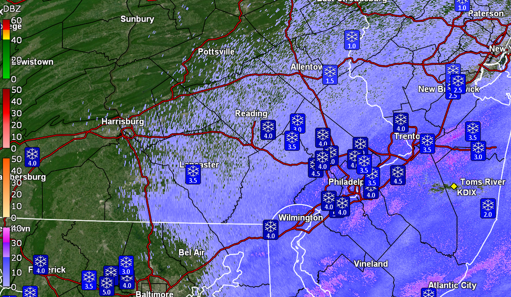
-
January 19, 2024 Powder Snow Event
Hurricane Agnes replied to Ralph Wiggum's topic in Philadelphia Region
My 3 pm measurement was 4" on the nose. So far the winds have been non-existent, so I haven't seen any snow blowing around. Am down to SN- with fine flakes, a temp of 28 and dp 26. -
January 19, 2024 Powder Snow Event
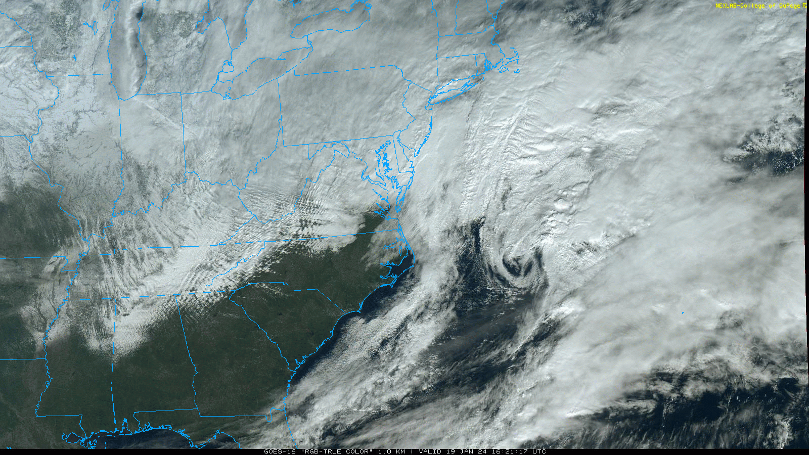
Hurricane Agnes replied to Ralph Wiggum's topic in Philadelphia Region
You can see that one low rolling OTS!
-
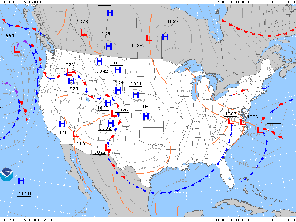
January 19, 2024 Powder Snow Event
Hurricane Agnes replied to Ralph Wiggum's topic in Philadelphia Region
Last HPC surface map (from about an hour ago I believe) -