Hurricane Agnes
-
Posts
9,344 -
Joined
Content Type
Profiles
Blogs
Forums
American Weather
Media Demo
Store
Gallery
Everything posted by Hurricane Agnes
-
E PA/NJ/DE Winter 2023-2024 OBS/Discussion
Hurricane Agnes replied to The Iceman's topic in Philadelphia Region
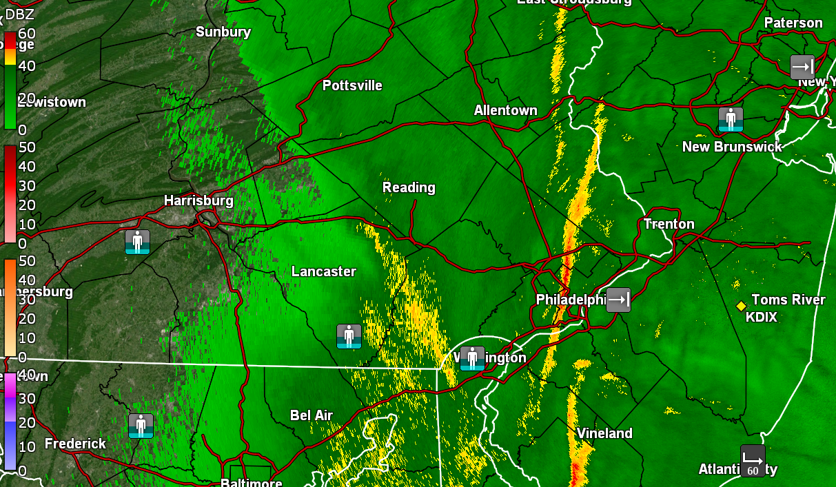
Getting an alert here now (for Montco to my NW). See the dark clouds to north. -
E PA/NJ/DE Winter 2023-2024 OBS/Discussion
Hurricane Agnes replied to The Iceman's topic in Philadelphia Region
It's torching (in a relative sense) where I am with temp now 42 (am guessing as downsloping ahead of a front). -
E PA/NJ/DE Winter 2023-2024 OBS/Discussion
Hurricane Agnes replied to The Iceman's topic in Philadelphia Region
Am thinking RedSky is under this and is either outside naked dancing around it or is napping.
-
E PA/NJ/DE Winter 2023-2024 OBS/Discussion
Hurricane Agnes replied to The Iceman's topic in Philadelphia Region
Junk and stuff incoming for some! ETA to note that temp here in NW Philly IMBY is 41 with dp 28 so not sure what would happen if that hung together and moved this way.
-
E PA/NJ/DE Winter 2023-2024 OBS/Discussion
Hurricane Agnes replied to The Iceman's topic in Philadelphia Region
State College has a Snow Squall Warning up for the area E of town/airport - Currently have changeable skies (sun has popped out recently) and 36 with dp 26.
-
E PA/NJ/DE Winter 2023-2024 OBS/Discussion
Hurricane Agnes replied to The Iceman's topic in Philadelphia Region
ETA - The map is weird but I think that it is 2" area-wide with the 3" lollipops. There are parts of NW DC Metro, e.g., Montgomery County, MD, and NW Philly (like where I am), as well as Montgomery County, PA, that have rolling hills with elevations of 300 ft - 400 ft. Ever since I was a kid (and even today), I was always fascinated on car trips to Willow Grove traveling north along Easton Rd. - especially going down the hill from Edge Hill Rd to Susquehanna Rd where the Roslyn train station is (which has an at-grade RR crossing, one of the few in the area). Similarly, I had many work trips down to D.C. metro and specifically the Rockville/Bethesda/Gaithersburg area, where the hills abound (as well as the propensity for severe storms, not unlike Willow Grove). So far I may have bottomed out at 29 this morning (but will see what happens in the next hour or so) and am currently at 30 with dp 23. Will be on the lookout for flizzards and whatnot. -
I just saw where the Bills/Steelers game was moved to Monday at 4:30 pm due to an incoming blizzard. (*ducks as Birds yells WIMPS!!!!!! and hurls stuff* )
-
E PA/NJ/DE Winter 2023-2024 OBS/Discussion
Hurricane Agnes replied to The Iceman's topic in Philadelphia Region
Well it did keep some shovelable for Tues/Wed.
-
E PA/NJ/DE Winter 2023-2024 OBS/Discussion
Hurricane Agnes replied to The Iceman's topic in Philadelphia Region
Just when I though things were done earlier this morning when the sun came out, it clouded over again and I got an additional 0.06" of rain from a band that came through the past couple hours. That brings the total to 0.59" for the day (0.96" 2-day total). My high ended up being 58 just after 6 this morning and it's down to 48 and clearing, with some sun, and dp 40. -
E PA/NJ/DE Winter 2023-2024 OBS/Discussion
Hurricane Agnes replied to The Iceman's topic in Philadelphia Region
Have some leftover light rain moving through but so far picked up 0.37" last night and 0.53" this morning for a 2-day event total of 0.90". My "low" in this non-diurnal temp regime, was 49 at midnight, and so far my "high" has been my current 57, with dp 57. PHL hasn't gone below 0F in 30 years (since 1994). -
E PA/NJ/DE Winter 2023-2024 OBS/Discussion
Hurricane Agnes replied to The Iceman's topic in Philadelphia Region
My snow drops have been spotted coming up so there's that. Bottomed out at 29 this morning and made itu p to 49 for a high. There was an active breeze today as well. Cloud deck has moved in and some junk-n-stuff off to the west. Currently 45 with dp 35. -
E PA/NJ/DE Winter 2023-2024 OBS/Discussion
Hurricane Agnes replied to The Iceman's topic in Philadelphia Region
Due to the non-diurnal temps post-storm, my "high" happened at 12:30 am and my "low" is my current temp of 45 (so far), with dp 32. It was good to see the sun dry things out a bit but the ground is saturated and thanks to the winds today, there were lots of branches around, although not as bad as it probably could have been. Was glad the power held! Looks like Chester County had the biggest impact for power outages. -
January 9th Wind/Rain/Flood OBS
Hurricane Agnes replied to Mikeymac5306's topic in Philadelphia Region
Heard this morning the Delaware hit a record peak at 10.66 ft for the day (at Washington Ave in South Philly). I know one small section further north on Columbus Blvd near the Ben Franklin Bridge is like 5 ft below sea level, so that will periodically have some very minor flooding with the tides.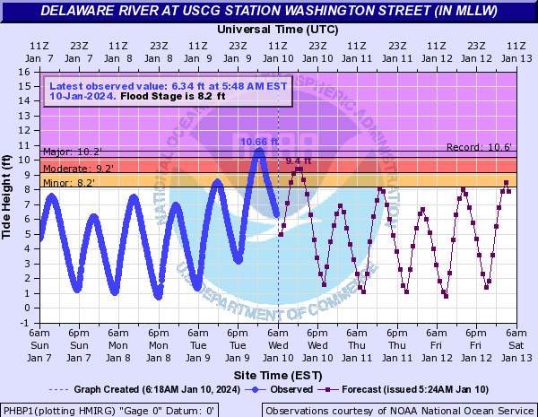
-
January 9th Wind/Rain/Flood OBS
Hurricane Agnes replied to Mikeymac5306's topic in Philadelphia Region
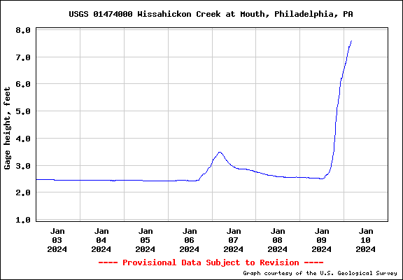
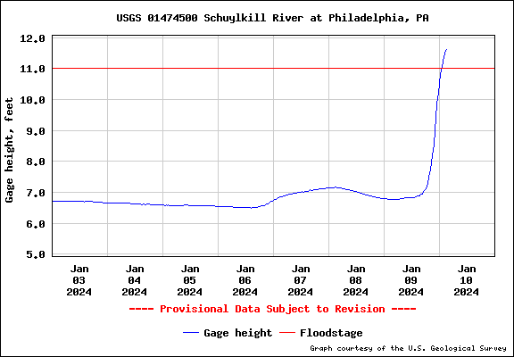
Finished up with 3.39" of rain from the event and a small line came through here the past hour but didn't produce anything measurable here. Currently 52 with dp 48. Wissahickon still rising (7.34 ft) and Schuylkill at PHI is flooding (11.62 ft) and still going.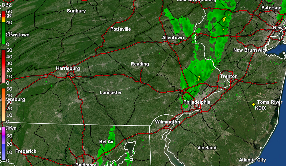
-
January 9th Wind/Rain/Flood OBS
Hurricane Agnes replied to Mikeymac5306's topic in Philadelphia Region
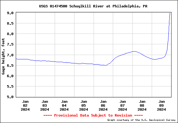
Temp down to 55 with dp 55. Some moderate rain bands coming through and have 3.23" recorded so far. Wissahickon is at 6.05 ft as pf 10 pm so way way out of its banks. Schuylkill @ PHL is at 8.99 ft so quickly getting there.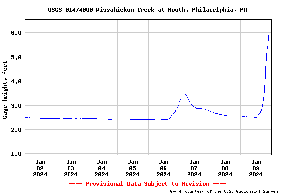
-
January 9th Wind/Rain/Flood OBS
Hurricane Agnes replied to Mikeymac5306's topic in Philadelphia Region
Temperature drop is real and now down to 56 with dp 56. My high hit 58 at 9:30 pm tonight. Rain rate has dropped considerably and currently have 3.08" in the bucket. Back edge looks to be in Lancaster County. -
January 9th Wind/Rain/Flood OBS
Hurricane Agnes replied to Mikeymac5306's topic in Philadelphia Region
New Moon is Thursday so the tides are normally running a bit higher (luckily it's not the Full Moon I guess). Schuylkill @30th St. is responding and at 6ft (as of 9pm).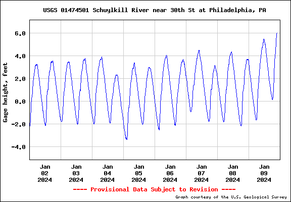
-
January 9th Wind/Rain/Flood OBS
Hurricane Agnes replied to Mikeymac5306's topic in Philadelphia Region
Schuylkill at PHI rising but still has some room (but with what has to come, will probably hit some kind of flood stage).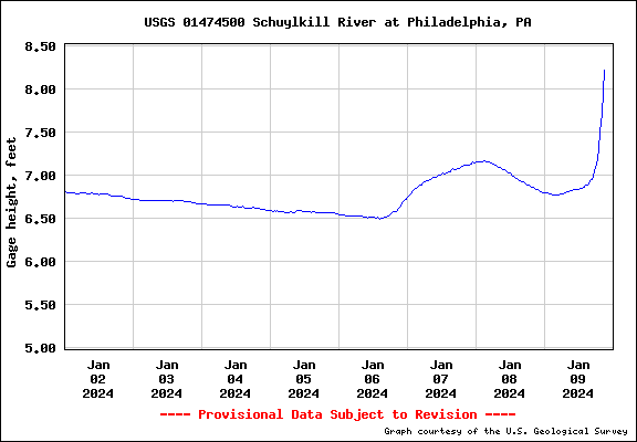
-
January 9th Wind/Rain/Flood OBS
Hurricane Agnes replied to Mikeymac5306's topic in Philadelphia Region
Now at 3.01", temp 57 but creeping down, dp 56. Wissahickon definitely out of its banks (9pm @ 5.4ft) and probably flooding Lincoln Drive.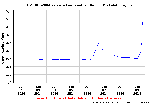
-
January 9th Wind/Rain/Flood OBS
Hurricane Agnes replied to Mikeymac5306's topic in Philadelphia Region
Got up to 1.91"/hr rate and have 2.95" in the bucket. -
January 9th Wind/Rain/Flood OBS
Hurricane Agnes replied to Mikeymac5306's topic in Philadelphia Region
Yeah they are going to have to wait that out. -
January 9th Wind/Rain/Flood OBS
Hurricane Agnes replied to Mikeymac5306's topic in Philadelphia Region
Now under the beginning of the rope. Rain is LOUD along with the wind. over 1"/hr rates.
-
January 9th Wind/Rain/Flood OBS
Hurricane Agnes replied to Mikeymac5306's topic in Philadelphia Region
We'll soon end up in Idaho with Kirk chopping wood! Temp now up to 58, dp 57, 2.62" in the bucket and rope on my doorstop just a few miles to the west. -
January 9th Wind/Rain/Flood OBS
Hurricane Agnes replied to Mikeymac5306's topic in Philadelphia Region
I'm finally "hearing" the howling winds here (from my front which is rare - I usually hear the winds in the back that faces NE). Wissahickon Creek (at the mouth to the Schuylkill) pretty much out of its banks now as of 8 pm so probably worse with the 9 pm update).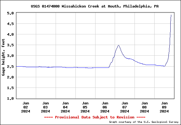
-
January 9th Wind/Rain/Flood OBS
Hurricane Agnes replied to Mikeymac5306's topic in Philadelphia Region
My Upper Darby sis said it's like a tornado where she is - winds howling, patio furniture moving around, things thumping, planes flying low.