Hurricane Agnes
-
Posts
9,336 -
Joined
Content Type
Profiles
Blogs
Forums
American Weather
Media Demo
Store
Gallery
Everything posted by Hurricane Agnes
-
E PA/NJ/DE Winter 2023-2024 OBS/Discussion
Hurricane Agnes replied to The Iceman's topic in Philadelphia Region
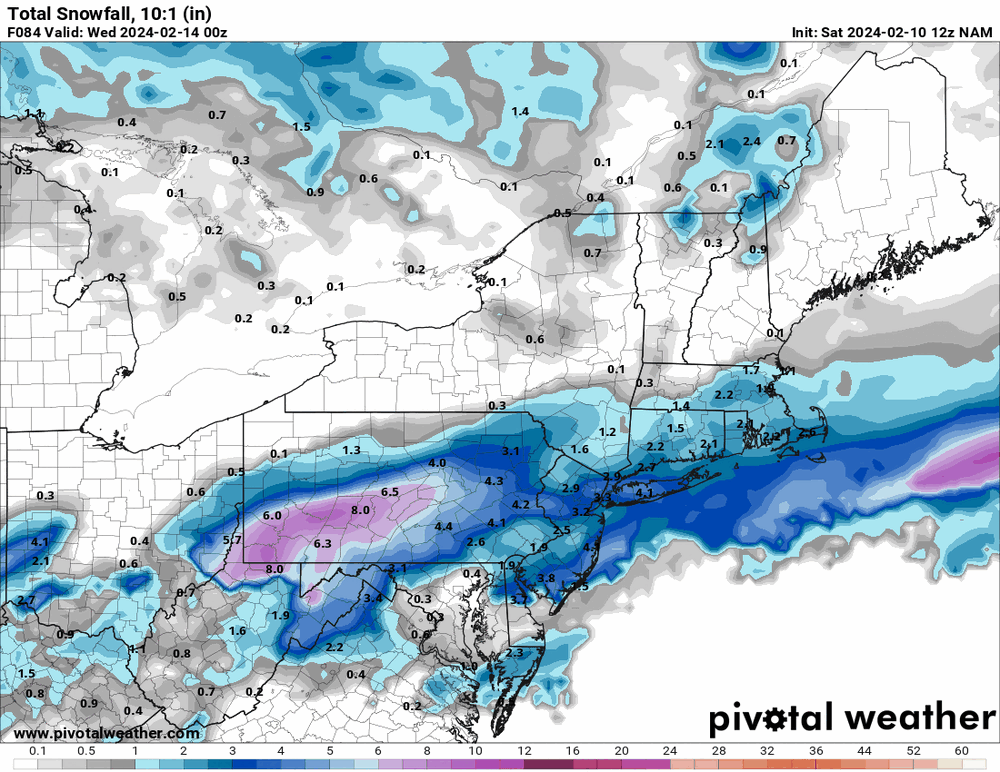
12z GFS was slower than the 12z NAM and further north, where the NAM had that southern look with a bulk of precip way west.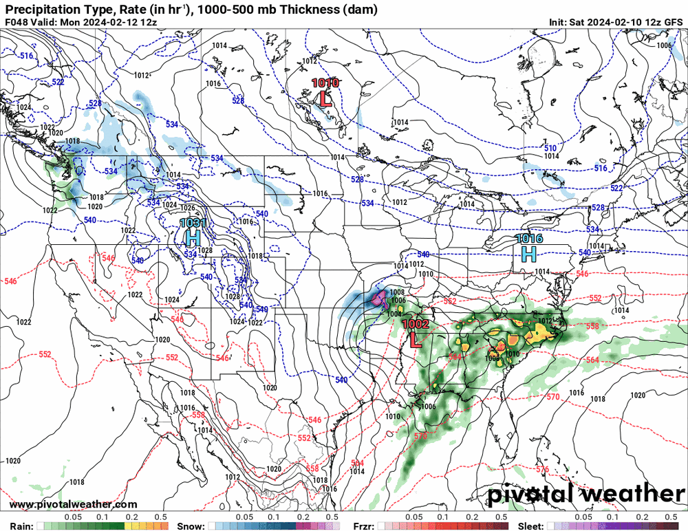

-
E PA/NJ/DE Winter 2023-2024 OBS/Discussion
Hurricane Agnes replied to The Iceman's topic in Philadelphia Region
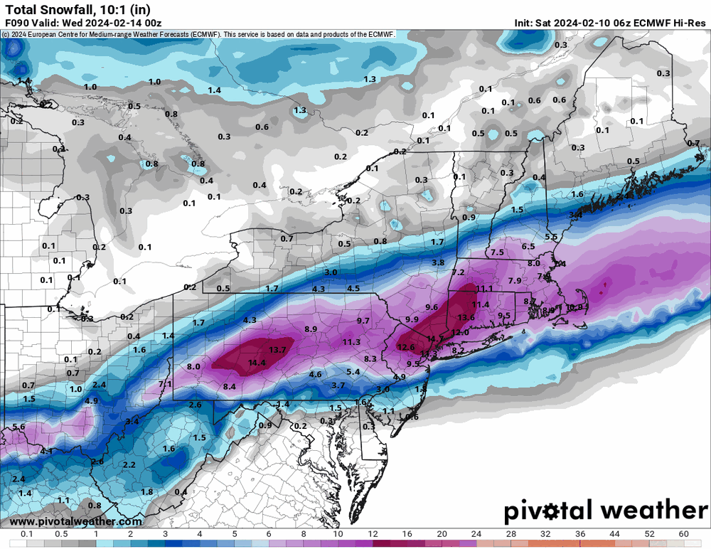
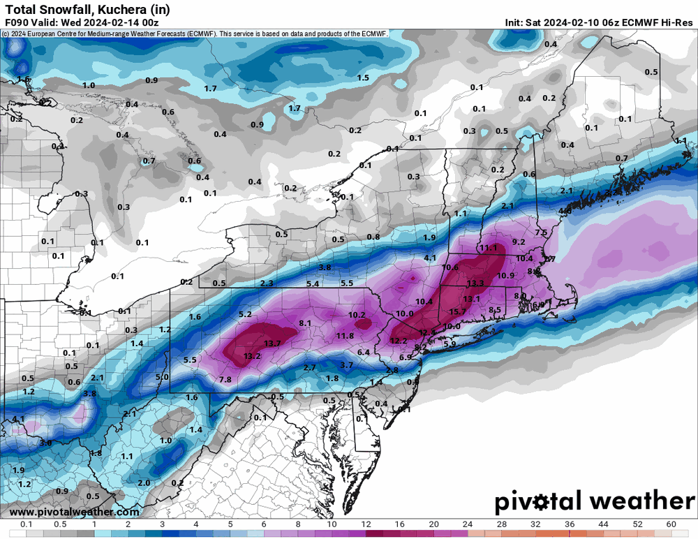
6z hi-res EC.
-
E PA/NJ/DE Winter 2023-2024 OBS/Discussion
Hurricane Agnes replied to The Iceman's topic in Philadelphia Region
12k NAM is slowly coming into range and the last frame of the run does hint at the same "north and west" trend.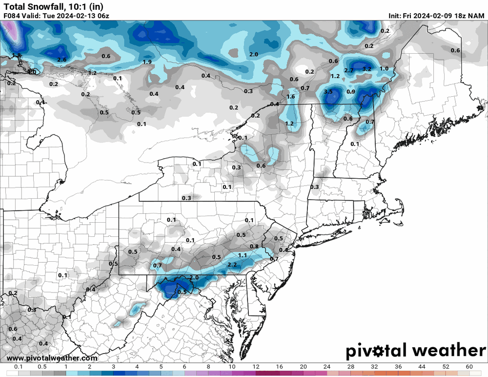
-
E PA/NJ/DE Winter 2023-2024 OBS/Discussion
Hurricane Agnes replied to The Iceman's topic in Philadelphia Region
I think it's a foregone conclusion that it is an I-78 / I-80 special. The track and any deathbands that might set up (including with the pivot) will determine how much. -
E PA/NJ/DE Winter 2023-2024 OBS/Discussion
Hurricane Agnes replied to The Iceman's topic in Philadelphia Region
-
E PA/NJ/DE Winter 2023-2024 OBS/Discussion
Hurricane Agnes replied to The Iceman's topic in Philadelphia Region
GFS basically looks like what the NBM had. It seems similar to our earlier first "threat" storm 1/15 - 1/16 with the antecedent warm temps and the attempt at a hop, skip, and jump (although missing a 2nd coastal nearby).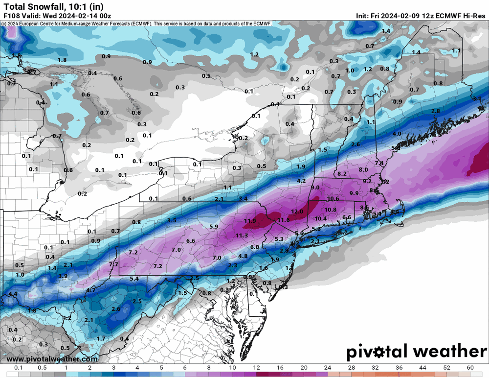
-
E PA/NJ/DE Winter 2023-2024 OBS/Discussion
Hurricane Agnes replied to The Iceman's topic in Philadelphia Region
13z NBM looks more realistic with that uncertainty about what might or might not happen with that "jump" (and how close to the coast or even inland the low goes).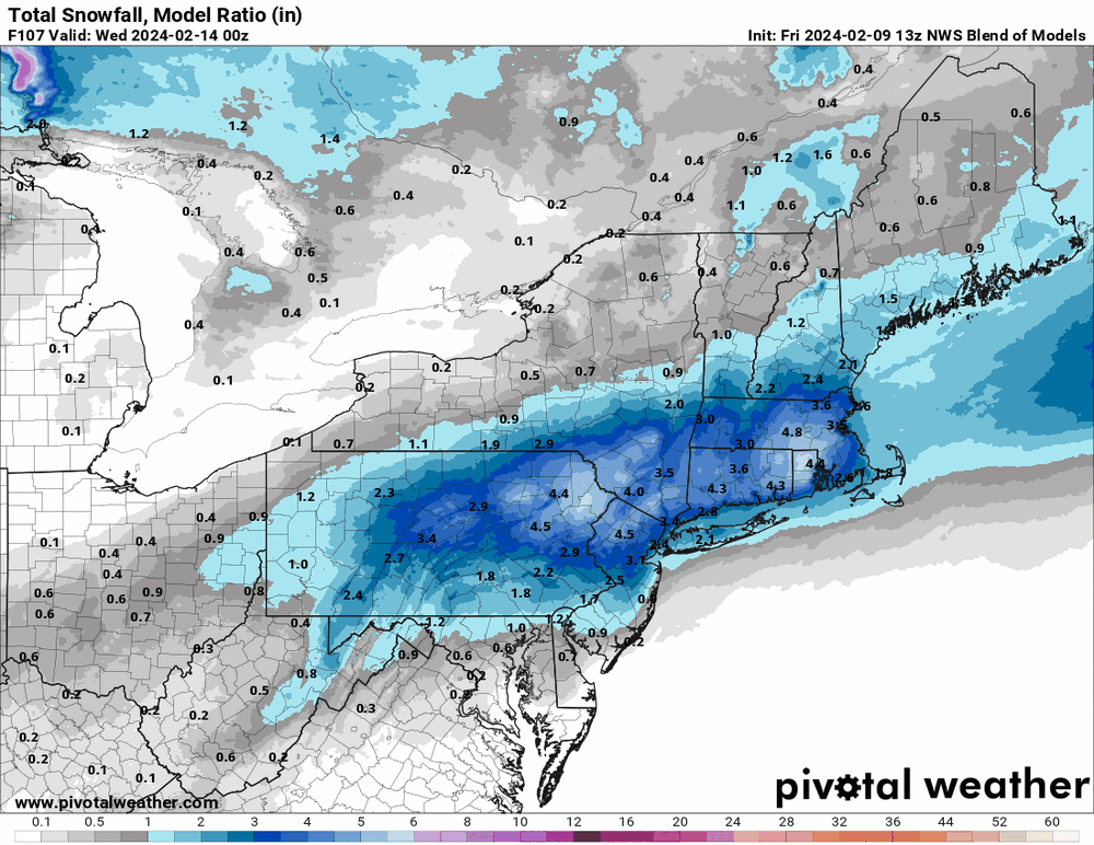
-
E PA/NJ/DE Winter 2023-2024 OBS/Discussion
Hurricane Agnes replied to The Iceman's topic in Philadelphia Region
Jinx!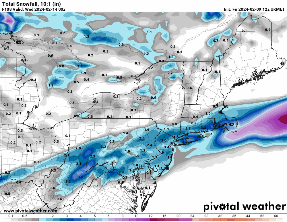
-
E PA/NJ/DE Winter 2023-2024 OBS/Discussion
Hurricane Agnes replied to The Iceman's topic in Philadelphia Region
Ukie is like "The GFS NAM'd you, so 'nope'".
-
E PA/NJ/DE Winter 2023-2024 OBS/Discussion
Hurricane Agnes replied to The Iceman's topic in Philadelphia Region
I know I have skunks around here and will go out to the patio and get greeted by their hellish "perfume"! It definitely appears to have ticked north and looks like it wanted to be an apps runner and then does the Miller-B jump.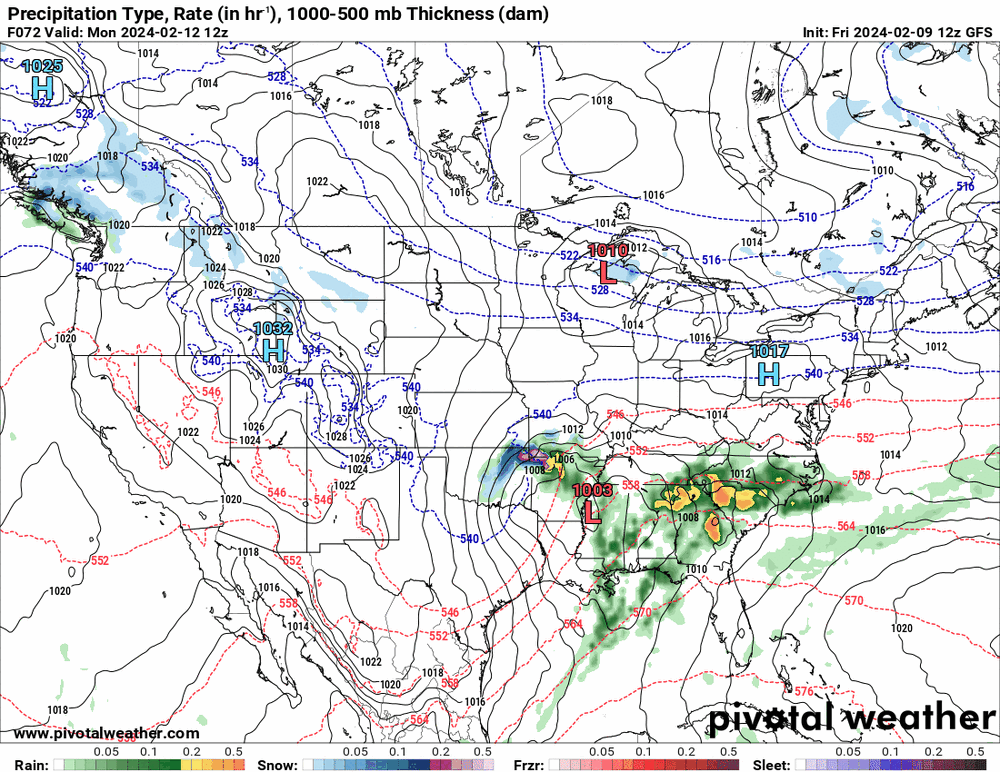

-
I had mentioned it here - It happened sometime in November around Thanksgiving.
-
E PA/NJ/DE Winter 2023-2024 OBS/Discussion
Hurricane Agnes replied to The Iceman's topic in Philadelphia Region
My Wyndmoor sister had texted yesterday about the foxes on her street whining and screaming all night. Am guessing it must be mating season or something. The 12z GFS is running so will see what happens. I bottomed out at 39 this morning and had noticed it had clouded over overnight. It's currently partly cloudy and 48 with dp way up there at 41. -
E PA/NJ/DE Winter 2023-2024 OBS/Discussion
Hurricane Agnes replied to The Iceman's topic in Philadelphia Region
It looks like it has the cold air coming in after the storm is off the coast though (unless it thinks some cold air will come with a little clipper-like low that precedes the coastal). -
E PA/NJ/DE Winter 2023-2024 OBS/Discussion
Hurricane Agnes replied to The Iceman's topic in Philadelphia Region
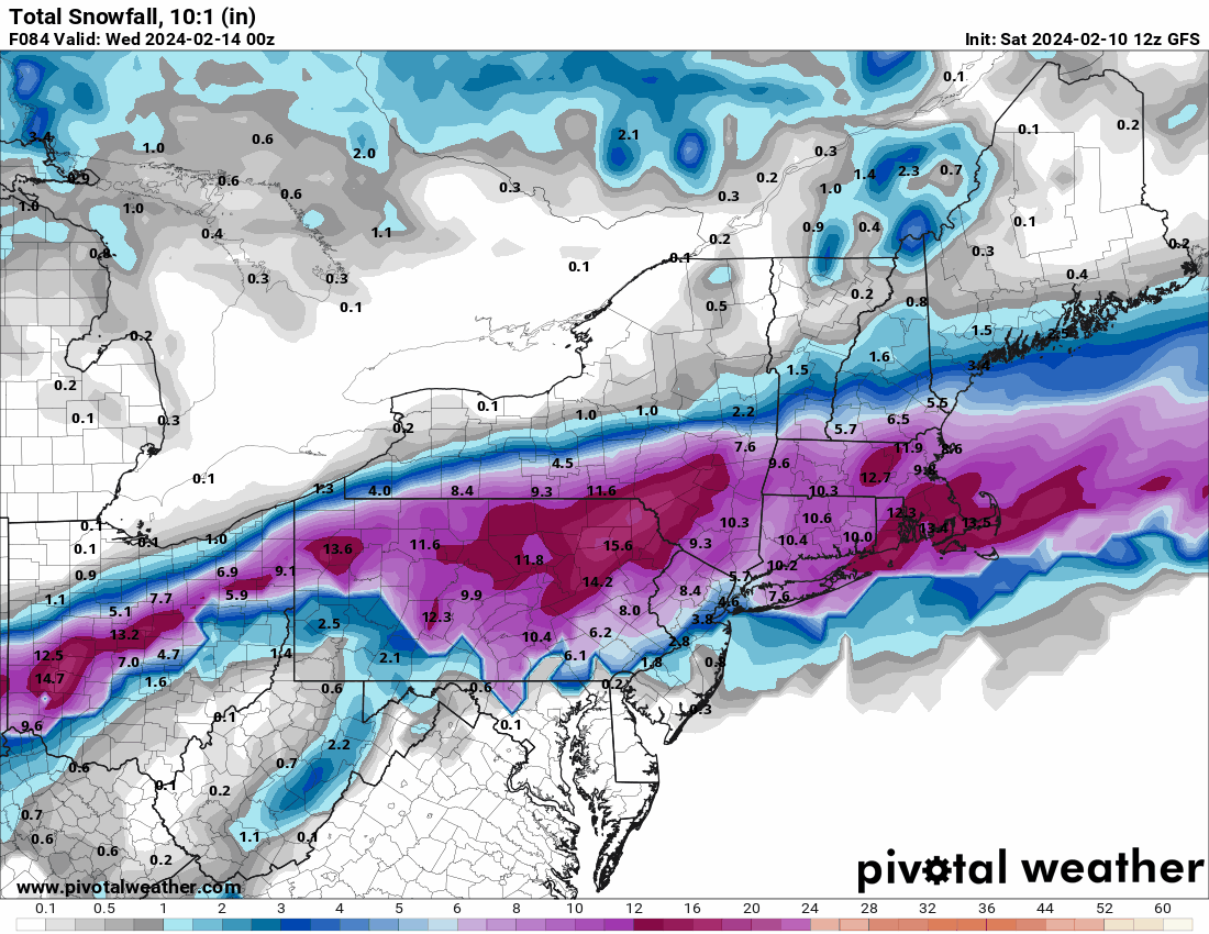
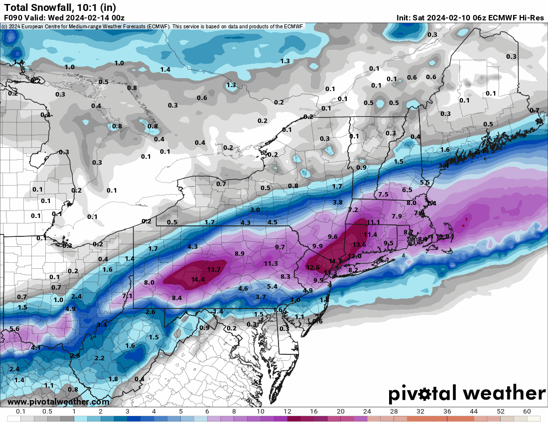
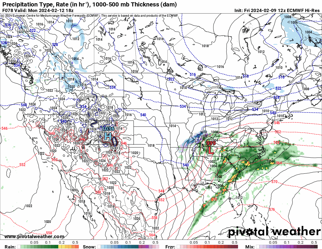
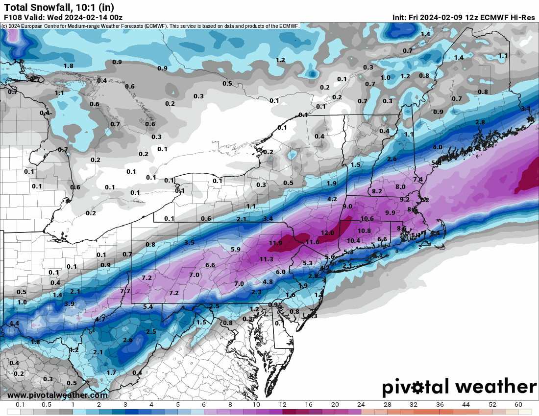
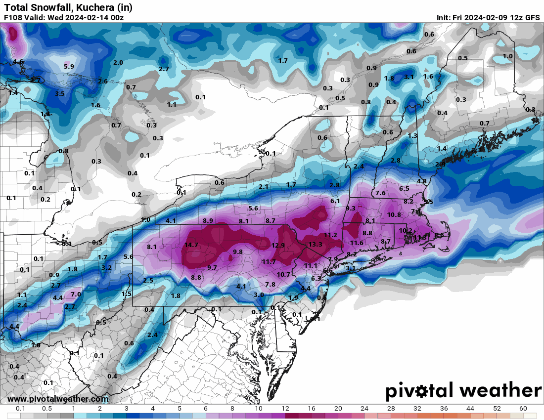
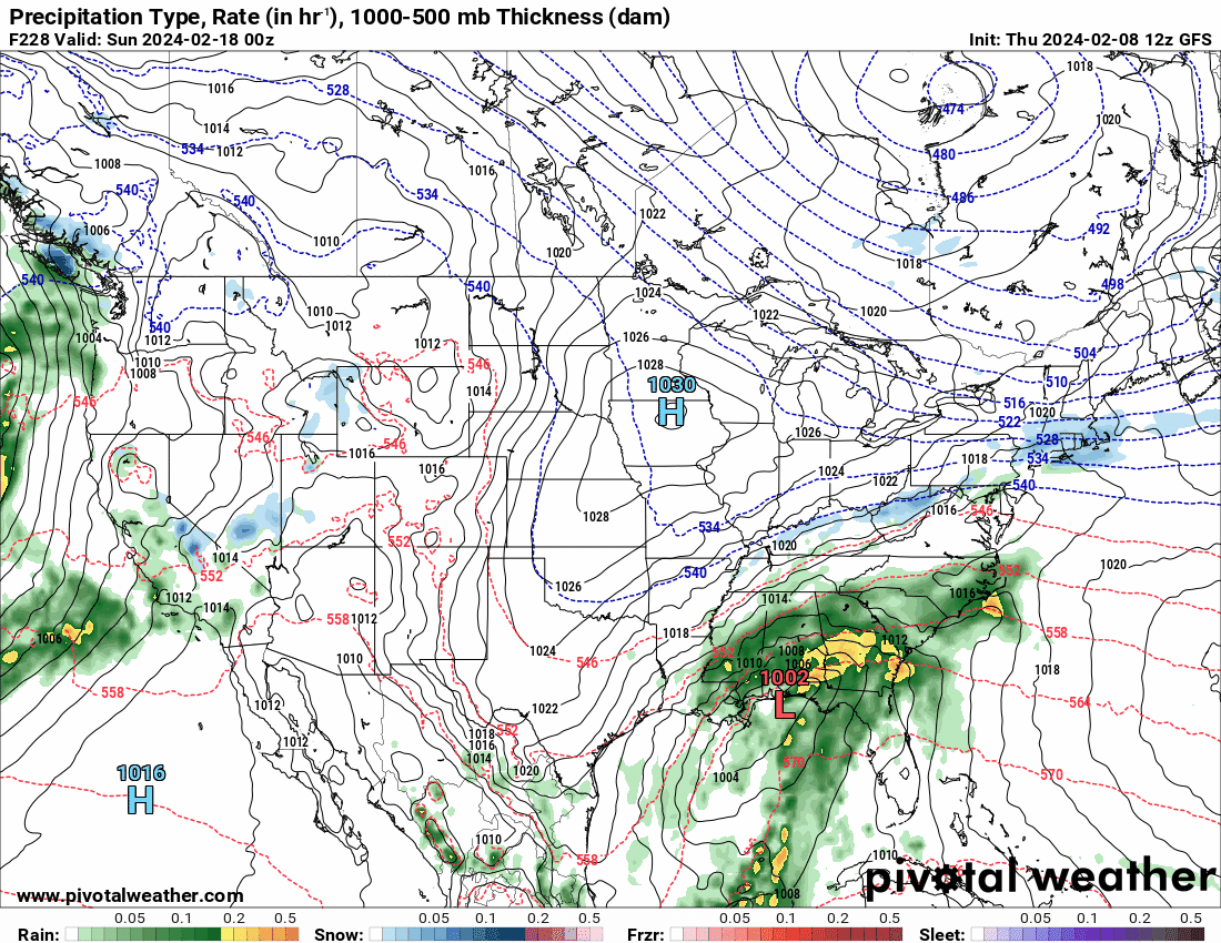
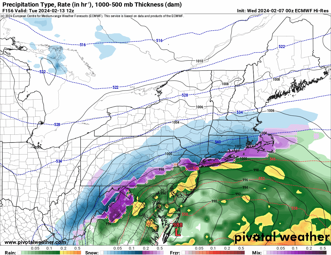
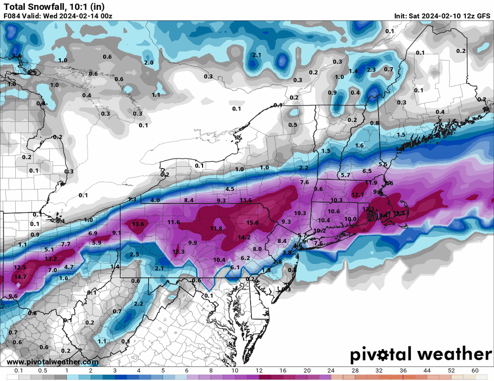
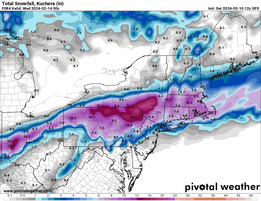
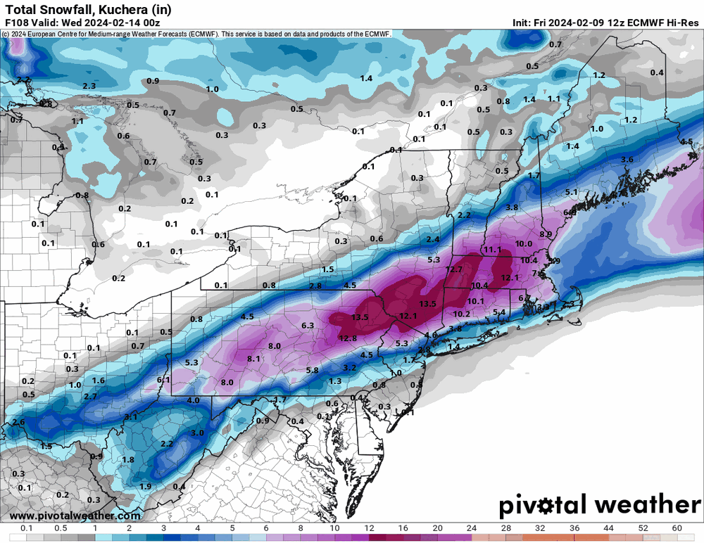
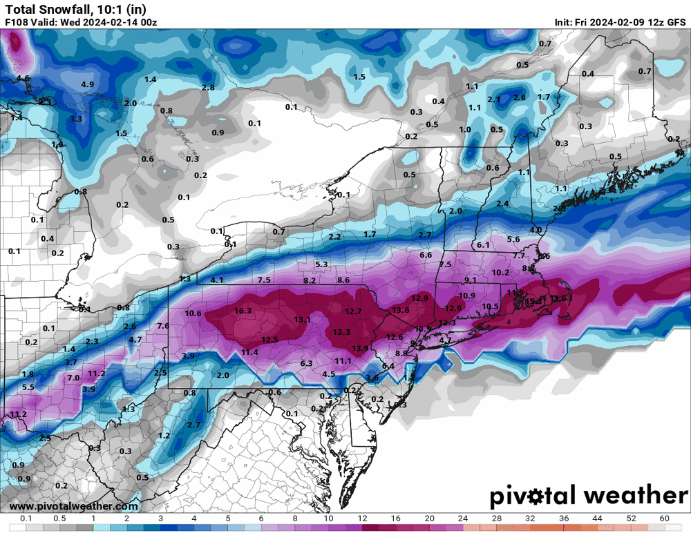
I just took a peak at the 12z Euro and 12z GFS for the 2/13 storm and they are like polar opposites (Euro north and GFS a DC metro bonanza). But thing is - the snow from them seem to happen for VD and stays around for the following week or so, and you can't really tell what any additional contribution would have been after VD with a 2nd storm around 2/18 - 2/21. And at least for the GFS range, the storm from the 18th - 21st is a slider, going south of Philly metro.
-
E PA/NJ/DE Winter 2023-2024 OBS/Discussion
Hurricane Agnes replied to The Iceman's topic in Philadelphia Region
After a chilly low of 28 this morning, I made it up to 46 for a high. The breeze was more noticeable today so it felt cooler than the high suggested although spots in the sun were "warm". It's currently clear and 43 with dp 28. -
E PA/NJ/DE Winter 2023-2024 OBS/Discussion
Hurricane Agnes replied to The Iceman's topic in Philadelphia Region
That's a Harrisburg, north and west special! Even with us now being pretty much at the "coldest" time of year for water temps (due to the natural lag), the surface temps are still in the mid-upper 40s off the coast. The 0z Euro has that low further south.
-
E PA/NJ/DE Winter 2023-2024 OBS/Discussion
Hurricane Agnes replied to The Iceman's topic in Philadelphia Region
Well we didn't quite get there the last time it hit close to 60, let alone 80 down in D.C. (although I think more north could still get flakes)! I think the model "climatology" pieces are unable to handle the changes in climate. -
E PA/NJ/DE Winter 2023-2024 OBS/Discussion
Hurricane Agnes replied to The Iceman's topic in Philadelphia Region
It's been good to see the sun for a somewhat extended period and my obs for highs the past couple days have been mainly mid 40s (45/46/45) with lows in the upper 20s - mid-30s (35/29/30). This morning the radiational cooling and dry air got me much colder, where so far my low has been 27. Currently 27 with dp 15. Looks like a torchy weekend ahead. -
E PA/NJ/DE Winter 2023-2024 OBS/Discussion
Hurricane Agnes replied to The Iceman's topic in Philadelphia Region
The Governor officially named Punxsutawney Phil the "official" PA State Meteorologist this morning. So far have 0.12" in the bucket today. -
E PA/NJ/DE Winter 2023-2024 OBS/Discussion
Hurricane Agnes replied to The Iceman's topic in Philadelphia Region
But there are still plenty of floodlights out there. Looks like Phil cancelled winter. -
E PA/NJ/DE Winter 2023-2024 OBS/Discussion
Hurricane Agnes replied to The Iceman's topic in Philadelphia Region
It may get stuck in the mud. When I was out yesterday running errands I did see a few surviving plowed mounds still occupying space in the store parking lots, albeit pretty much completely dirt covered. Well the first day of February started off with a low of 29 (with folks out there scraping frost off their car windshields) and made it to a high of 47. I finished January with 7.53" of liquid (although it was missing some rain when snow/ice-clogged with that storm #1 in mid Jan.). I did see the sun much of the day today but then as progged, it clouded over. It's currently 45 with dp 37. -
E PA/NJ/DE Winter 2023-2024 OBS/Discussion
Hurricane Agnes replied to The Iceman's topic in Philadelphia Region
Made it up to 37 yesterday after a low of 33 and had noticed the sidewalk was wet with some non-measurable precip yesterday evening (didn't see flakes at the time). Overnight registered 0.01" of liquid although again, am not sure if any of it was from flakes, light rain/drizzle, or a mix. The temp stayed above freezing overnight regardless. Currently a damp and misty 35 with dp 33. -
E PA/NJ/DE Winter 2023-2024 OBS/Discussion
Hurricane Agnes replied to The Iceman's topic in Philadelphia Region
Kamu's squirrels are looking for their mound and traveled up there to find one! The sun did manage to pop out earlier this morning but that didn't last long. It's currently 40 and overcast with dp 32. -
E PA/NJ/DE Winter 2023-2024 OBS/Discussion
Hurricane Agnes replied to The Iceman's topic in Philadelphia Region
The on and off drizzle/light rain rounds continued yesterday evening after my last report and I finished up with 1.07" yesterday. The precip. kept on coming overnight with 0.04" in the bucket this morning, resulting in a 5-day total of 1.64". Currently mostly cloudy and 38 with dp 35. -
E PA/NJ/DE Winter 2023-2024 OBS/Discussion
Hurricane Agnes replied to The Iceman's topic in Philadelphia Region
Bottomed out at 39 this morning and haven't moved much today, with a high so far of 42. The initial round of the heavy rain that began sometime after 1 am, netted me 0.93" before a pause. A lighter round ensued mid-morning with an additional 0.07" (so far) for a total of 1.00" on the nose at post time. Currently a misty 40 with dp 40. ETA to note that I have recorded 7.41" of liquid for the month (so far) although some of that is missing rain data during the transitions from snow/sleet to rain for the 1/15 - 1/16/24 storm that didn't make it through a snow/ice-clogged gauge and also includes delayed snow melt from the gauge.