Hurricane Agnes
-
Posts
9,343 -
Joined
Content Type
Profiles
Blogs
Forums
American Weather
Media Demo
Store
Gallery
Everything posted by Hurricane Agnes
-
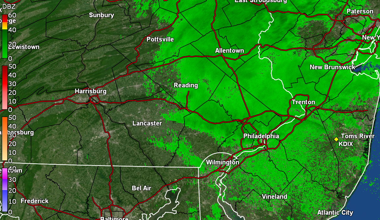
E PA/NJ/DE Fall 2023 OBS/Discussion Thread
Hurricane Agnes replied to Rtd208's topic in Philadelphia Region
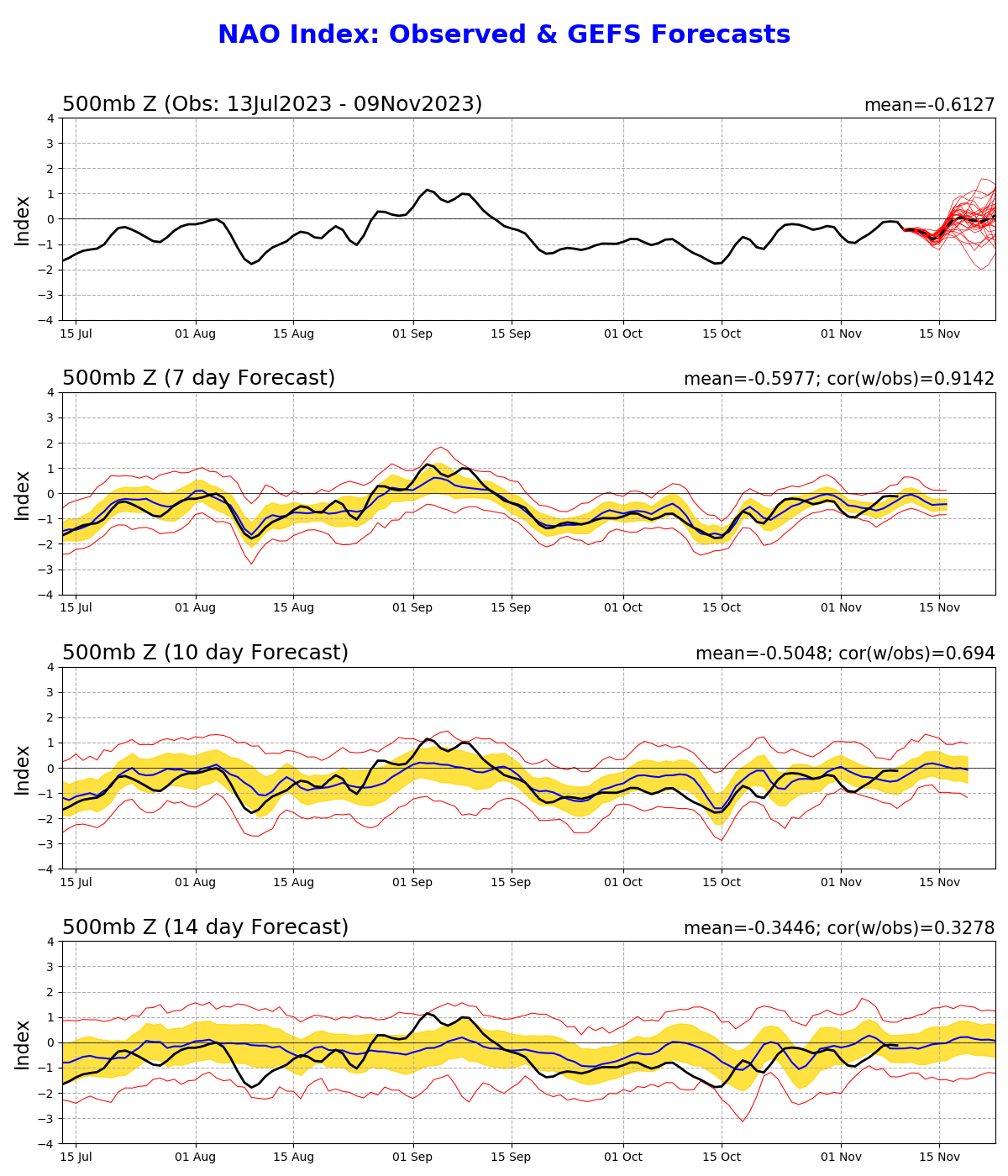
Latest CPC ENSO discussion released today - https://www.cpc.ncep.noaa.gov/products/analysis_monitoring/enso_advisory/ensodisc.shtml Calling for El Nino to continue at least through June 2024 with a 55% chance of it being "strong" through March 2024. MJO not really in a favorable phase at the moment. Te NAO has been mostly negative in varying degrees through last month although it seems to be forecast to go more neutral this month.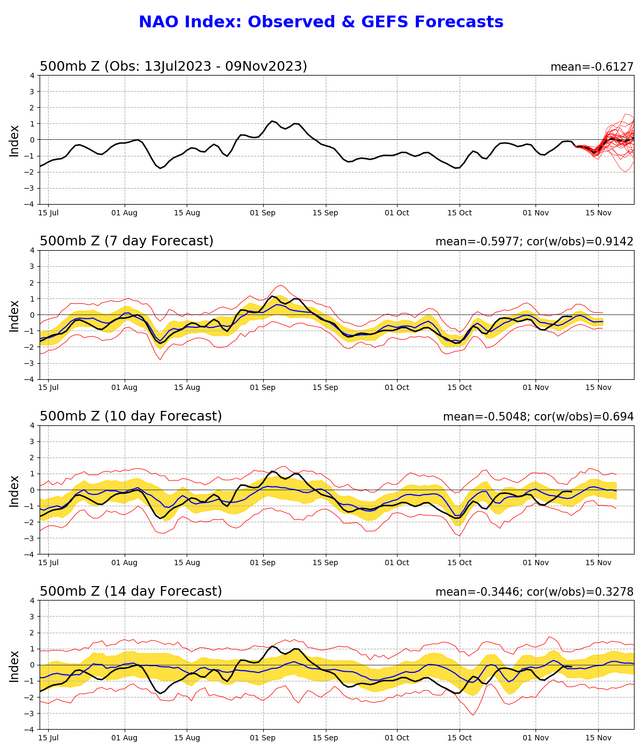
-
E PA/NJ/DE Fall 2023 OBS/Discussion Thread
Hurricane Agnes replied to Rtd208's topic in Philadelphia Region
Talk about the ups and downs this week! Highs IMBY from Saturday through to Wednesday have been 57, 66, 59, 65, and 53 respectively. The lows - 36, 39, 39, 51, 39. The low this morning was 41 and I would definitely say it has been unsettled but it has also been dry here. Have only had 0.03" for the month so far and actually finished up October with only 1.40". The sun had finally popped out later this morning and it's currently partly sunny and up to 61 with dp 52. Still haven't put the heat on yet although I had my little portable going a few days for some spot warmth. I had ventured out around the neighborhood and got some gas earlier this week and noticed that probably 1/2 of the maples (mostly younger trees and both Norway and sugar) still have leaves, so haven't had the big 2nd dump yet. -
E PA/NJ/DE Fall 2023 OBS/Discussion Thread
Hurricane Agnes replied to Rtd208's topic in Philadelphia Region
Eventually made it up to 48 as a high yesterday and bottomed out a degree warmer this morning than yesterday morning, with a low of 31. This time, the winds went completely calm overnight so that assisted the radiational cooling. The frost was definitely heavy this morning though vs yesterday and it looks like my high was 56 today under blue skies. Currently 55 and sunny with dp 34. -
E PA/NJ/DE Fall 2023 OBS/Discussion Thread
Hurricane Agnes replied to Rtd208's topic in Philadelphia Region
I am still surprised that I ended up with a 4-day string of light precip that totaled 0.40" (had a sneaky 0.10" Tues. and 0.03" yesterday morning). The high yesterday never made it to 50 (was 49) after a low of 33 and this morning I bottomed out at 30.0 on the nose. I noticed that the winds never went completely calm here overnight. The dp was in the mid 20s once the CAA blew dry air in. Got the last of my tender subtropicals in but still have the potted fig out there to go dormant and drop its leaves before I bring that in. Am still resisting turning the heat on (have a portable to take the chill off where I am sitting at the moment) because once I do that, I have to get my humidifiers up and running. It's supposed to warm up by the weekend in any case. Currently mostly sunny and 38 with dp 29. -
E PA/NJ/DE Fall 2023 OBS/Discussion Thread
Hurricane Agnes replied to Rtd208's topic in Philadelphia Region
Ended up with nickel and dime showers yesterday and this morning, with 0.13" yesterday and 0.07" so far this morning, for a 2-day event total of 0.20" so far. My "low" was 53 just after 2 pm yesterday and confirmed the high for yesterday being just after midnight of 66. This morning's low so far has been 51 and within the past hour or so, I have been socked in with some low stratus, so "something" is on the move. Currently overcast and misty and 56 with dp 55. -
E PA/NJ/DE Fall 2023 OBS/Discussion Thread
Hurricane Agnes replied to Rtd208's topic in Philadelphia Region
Something something, Lucy, football. The GFS has been non-stop spinning up storms in the long range, literally doing that all summer and into the fall. My Friday split was 73/54 and yesterday I just touched 80 after a low of 59. My registered low earler this morning was 57 and after a few non-measurable sprinkles that wet the car and walk, my current temp has now dropped below that to 56, where my "high" (so far) was just after midnight at 66. Dewpoint is currently 51 with overcast skies. -
E PA/NJ/DE Fall 2023 OBS/Discussion Thread
Hurricane Agnes replied to Rtd208's topic in Philadelphia Region
Whelp - didn't frost here Tuesday morning although I did have a low of 39. Ended up with a high of 65 that day. The Wed. split was 44/72 and today the warming trend continued with a 48 low and much warmer high of 78. As soon as the sun set, the cooling commenced however, and it's currently 63 with dp 56. Will see if any records fall this weekend. And I won't even get into the Phillies. Bad Closers are toxic and I expect that this sentiment probably rippled through the team as there were a couple games that would have been won if runs hadn't been given up in the late innings. Anyway... Go IGGLES. Kelly Green FTW. -
E PA/NJ/DE Fall 2023 OBS/Discussion Thread
Hurricane Agnes replied to Rtd208's topic in Philadelphia Region
Since the season has been transitioning, have been getting my potted tropicals/subtropicals/tender perennials ready to bring in (and/or have started bringing them in). My highs have continued to warm with a 65, 67 & 69 respectively from Wed. -> Fri. after respective varying lows of 48, 42, & 54, dependent on how much radiational cooling was achieved. I ended up with 0.04" of rain with the morning round on Friday and with some promising later rain with the solid line, I got one huge NADA (yes the below attached was the look just before heading off to bed and it resulted in Phillies-style strikeouts)! Am hoping the coastal that is forming with backwash over me some. In any case, it's currently a humid 56 with dp 55.
-
E PA/NJ/DE Fall 2023 OBS/Discussion Thread
Hurricane Agnes replied to Rtd208's topic in Philadelphia Region
Highs have gradually warmed the past couple days and were 60 (Sun.), 62 (Mon.), and 63 for today. My low yesterday was a chilly 44 but a milder 50 this morning. It's currently mostly cloudy after a sunny start, and 59, with dp 48. Have been watching the scattered showers on radar and haven't cashed in on any although yesterday I had some non-measurable that spritzed on the car. -
E PA/NJ/DE Fall 2023 OBS/Discussion Thread
Hurricane Agnes replied to Rtd208's topic in Philadelphia Region
Ended up with highs of 64 on Friday and of 52 on Saturday, after lows of 50 and 46 respectively. Picked up 0.78" yesterday and 0.14" today (total for the 2-day event was 0.92") and had a low of 47 this morning. It's currently breezy and mostly sunny, with only a few scattered clouds, and 57. The dewpoint is sitting at a nice low of 48. -
E PA/NJ/DE Fall 2023 OBS/Discussion Thread
Hurricane Agnes replied to Rtd208's topic in Philadelphia Region
Have had a gradual warm up for daytime temps this week, topping off at 61 Mon., 62 Tues., 68 yesterday, and 69 today. Lows during that period from Tues. were 46, 45 Wed., and 47 this morning, so still reflecting some radiational cooling. It had been clouding up as the day progressed and was mostly cloudy ahead of the sunset, and 60 with dp 50. -
E PA/NJ/DE Fall 2023 OBS/Discussion Thread
Hurricane Agnes replied to Rtd208's topic in Philadelphia Region
Bottomed out at 43 this morning and hit a high of 61. Coolest low since May 18 here, which was a 41. Had a nice sunny fall day punctuated with occasional cumulus and CAA stratocumulus. It's currently 54 with dp 46! -
E PA/NJ/DE Fall 2023 OBS/Discussion Thread
Hurricane Agnes replied to Rtd208's topic in Philadelphia Region
Eventually dropped to about 59 before briefly recovering to about 60 after fropa and the sun coming out, but got ZERO measurable rain, with enough to wet the walk but not enough to tip the bucket. Currently mostly cloudy with some peeps of sun here and there about 20 minutes before sunset, and 59 with dp 53. -
E PA/NJ/DE Fall 2023 OBS/Discussion Thread
Hurricane Agnes replied to Rtd208's topic in Philadelphia Region
Made it up to 78 for a high yesterday and this morning had initially bottomed out at a humid 66. Got up to 73 w/dp 69 @9:50 am before the bottom dramatically dropped out. Currently overcast and teasing rain (but none so far yet either overnight or this morning), and am at 67 with dp 62.
-
E PA/NJ/DE Fall 2023 OBS/Discussion Thread
Hurricane Agnes replied to Rtd208's topic in Philadelphia Region
Well I bottomed out at 60 yesterday and "only" got up to 82 here as a high yesterday too, probably because of various and sundry clouds. Got good radiational cooling overnight and had a low of 55 ealy this morning, but am quickly off to the races now where I'm currently partly sunny and 71, with dp 64. -
E PA/NJ/DE Fall 2023 OBS/Discussion Thread
Hurricane Agnes replied to Rtd208's topic in Philadelphia Region
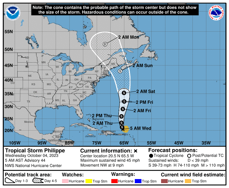
LOL I don't know about the "frost" part... We (at least in the NW part of the city) don't usually get the first potential frost until maybe mid-late Oct (meaning a day or so with lows in the mid-upper 30s). Heck, the way the erratic track of TS Philippe keeps changing means we could get a full on blizzard out of it eventually. It wasn't supposed to get anywhere near the CONUS. After a low of 57 yesterday, I made it up to 80 as a high. It's currently partly sunny and 64 with dp 64.
-
E PA/NJ/DE Fall 2023 OBS/Discussion Thread
Hurricane Agnes replied to Rtd208's topic in Philadelphia Region
First of October I hit 77 for a high after a 58 low and today hit 79 after bottoming out at 61. Looks like a little "Indian Summer" coming this week. Currently 70 with a dp that has crept up to 65 and is noticeable. Critters going outside. -
E PA/NJ/DE Fall 2023 OBS/Discussion Thread
Hurricane Agnes replied to Rtd208's topic in Philadelphia Region
Zombie Ophelia ended up misting 0.02" of rain IMBY around 3 am this morning. That brought the 3-day event total to 0.43", with a final monthly total for September of 6.96" (assuming no more drifts this way). That was somewhat higher than last September's (2022) 6.11" total but fall less than September 2021's 8.57". It was twice as much as September 2020's 3.04" however (the year I got this particular station). Ended up hitting a high of 69 once the sun came out and stayed out, after a low of 58. It's currently 66 with dp 62. -
E PA/NJ/DE Fall 2023 OBS/Discussion Thread
Hurricane Agnes replied to Rtd208's topic in Philadelphia Region
Ended up with a surprise 0.05" of rain during a few hours before So far am at 6.92" for the month at post time. Bottomed out at 57 this morning and am currently at my high of 65 with dp 62 and overcast. The zombie Ophelia is doing a number on NY. -
E PA/NJ/DE Fall 2023 OBS/Discussion Thread
Hurricane Agnes replied to Rtd208's topic in Philadelphia Region
With the rare sun out yesterday, I topped out at 66 yesterday. And with a low of 52 this morning, I made it up to 63, with overcast all day (I understand some areas briefly had sun but not here). Currently overcast and 61 with dp 58 and stuff backing in off the ocean thanks to zombie Ophelia feeding some offspring. Meanwhile TS Philippe and Rina are getting it on in the central Atlantic.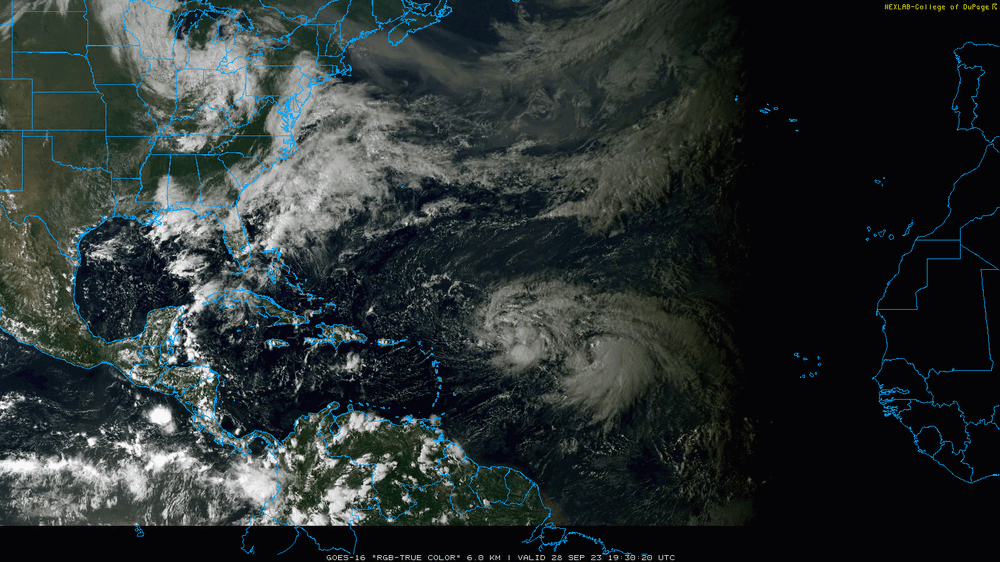
-
E PA/NJ/DE Fall 2023 OBS/Discussion Thread
Hurricane Agnes replied to Rtd208's topic in Philadelphia Region
Made it up to 59 yesterday after a low of 56 and with 0.03" of leftover Ophelia rain yesterday, I had a final total of 3.43" for the 4-day event. Bottomed out at 57 this morning and the sky is clearing (seeing some blue sky) but still mostly cloudy and 59, with dp 50. -
Actually picked up another 0.06" with the band pivot on top of the 0.01" from earlier, for today's total so far of 0.07" at post time (3.29" over 3 days).
-
E PA/NJ/DE Fall 2023 OBS/Discussion Thread
Hurricane Agnes replied to Rtd208's topic in Philadelphia Region
High yesterday did end up as 66. Picked up 0.01" between 3 - 4 am and with yesterday's 2.14" and Saturday's 1.08", have 3.23" for the 3-day event. Currently a damp and misty 61 with dp 60. -
Ended up with 2.14" yesterday while under that band, and coupled with the 1.08" from Sat. and another 0.01" early this morning, that is a whopping 3.23" over 3-days. I will say that none of it was from gully washer downpours. it was mostly 1/4 - 1/3" or less per hour rates that gave time to soak in.
- 144 replies
-
- 2
-

-

-
- potential tropical cyclone
- floods
- (and 2 more)
-
E PA/NJ/DE Fall 2023 OBS/Discussion Thread
Hurricane Agnes replied to Rtd208's topic in Philadelphia Region
And another 0.65" since the last posting while under that deathband for a 1.87" total for today and now 2.95" over the 2-days. Starting to feel like RedSky. Good thing I got some fall fertilizer out a couple weeks ago. Still getting very light rain and temp s 64 with dp 63.