

Hurricane Agnes
-
Posts
9,264 -
Joined
Content Type
Profiles
Blogs
Forums
American Weather
Media Demo
Store
Gallery
Everything posted by Hurricane Agnes
-
Mt. Holly tweeted a map of where they plan to investigate suspected tornadoes -
-
You all looked like you had a rain band just training over that area for hours.
-
I already did not long after midnight. Literally out within 15 minutes when I did. Got up at ~4:45 am. Being retired = being able to take a nap whenever I want during the day.
- 487 replies
-
- 3
-

-
- hurricane
- flooding potential
- (and 2 more)
-
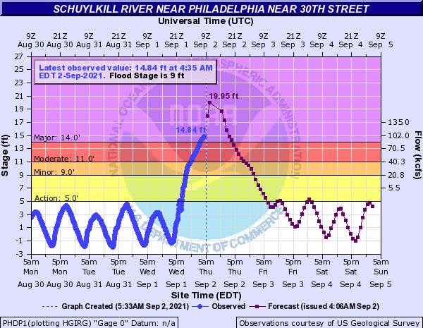
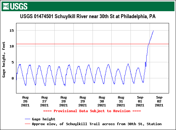
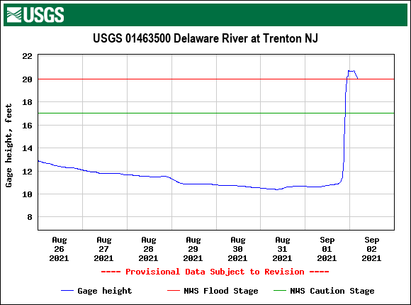
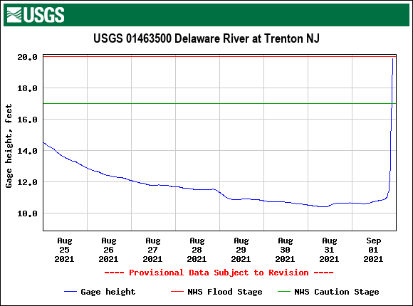
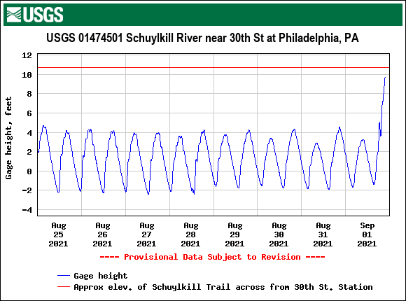
NWS MARFC retweeted KYW coverage - As a comparison - this was a pic of the same location (this is around 30th Street Station) at around 2 am (this is where the Schuylkill Expressway goes under the street level along the river) - If the level hits the progged 19 ft. that may put the Schuylkill Express way shown above, under water.
- 487 replies
-
- 1
-

-
- hurricane
- flooding potential
- (and 2 more)
-
WPC 5 am update (no change in winds, pressure, forward motion) -
-
Flooding at rivers and creeks around the area are going through extreme flooding.

-
No further rain overnight so still at 5.41" for the event. Currently 62 with dp 57.
-
Was still getting on and off rain and finished up with 5.41" for the day (since it is now past midnight). Any additional will make it a 2-day event. There's still a little back edge left so maybe a couple hundredths more might be added on if that. Currently overcast and 63 with dp 63.
-
Here is the latest - 3 hour delayed (for state workers) so appears the state will be open but the rivers haven't all crested yet so stay tuned because that might change.
-
The 100 year ones are annual though, so there's that.
-
Mt. Holly had posted a Climatology section in the AFD earlier this afternoon. I think it is safe to say that several sites including PHL broke a record for today!
-
The wildest thing though was that there was some huge tree trunk that had washed down the river with the currents that literally got wedged near the top of one of the stone arches of one of the (I think) railroad bridges that goes over the river near there. It was literally wedged straight across and it stayed up there for almost a year before someone finally removed it. There used to be pics of it on the internet years ago but I haven't been able to find one recently.
-
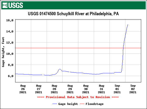
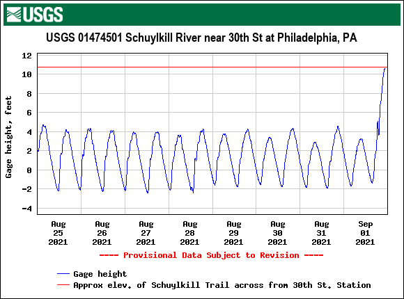
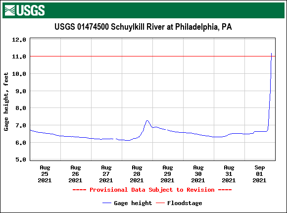
Schuylkill at 30th St. right at flood stage downtown.
-
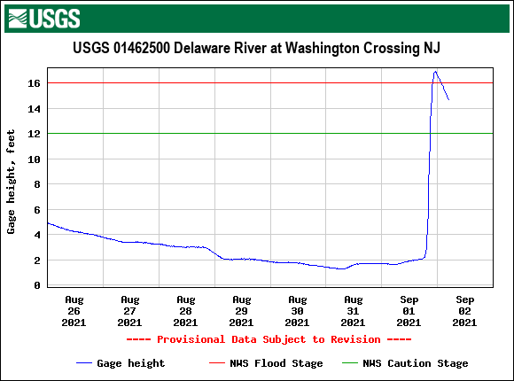
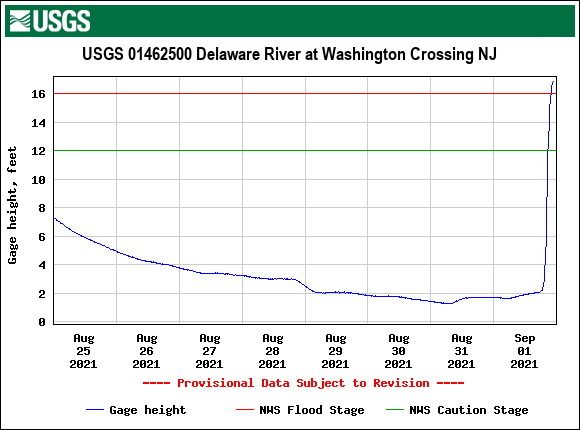
The Delaware at Washington Crossing is flooding. I also got a light blip of measurable rain and am now at 5.34" for the day.
-
KYW had an alert thingy (I have their audacy app) about Murphy having declared a state of emergency and had called out the National Guard.
-
Ugh. I remember when the river flooded pretty badly after the 1996 blizzard when the temp suddenly warmed and then there was some heavy rain. The muddy water lines were clearly visible on the huge plowed snow banks along Kelly Drive near the Falls Bridge and the water had come all the way up and over Ridge Ave. and had probably reached partially up the hills where Calumet or Midvale come down.
-
Latest Mt. Holly tweet -
-
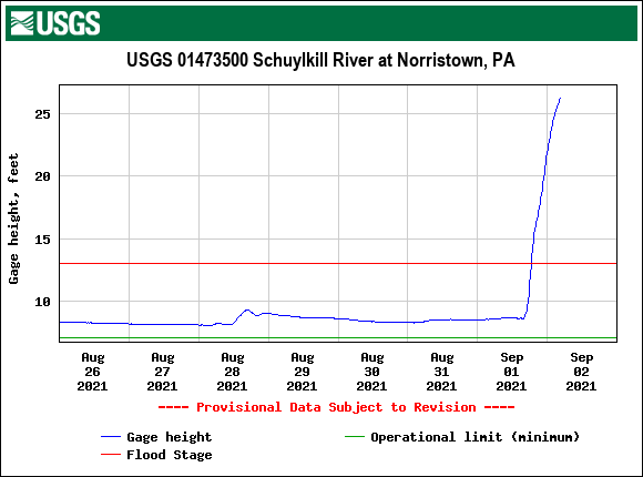
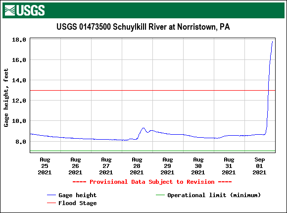
There is still rain coming down to the west and the river has already flooded way out of its banks in Norristown, so expect it to get a bit higher down there. Back edge is coming soon and has finally stopped (at least with the measurable) here so far. Currently at 5.33" for the event so far (0.56" round 1 and 4.77" for round 2). Currently breezy, overcast, misty and 63 with dp 62.
-
WPC 11 pm update (the rainstorm has strengthened to 40 mph, with pressure at 998 mb, and is now zipping along at 28 mph to the NE) -
-
Was just about to post it. The gauge is showing right around flood stage for the Delaware there.
-
Getting another heavy blip over me with almost over 3/4" per hr rates and am now up to 5.20" for the event so far. This time I'm getting some winds... It's almost like one of those windy rainy fall days now. Temp is 64 with dp of 63. I think my Stratus holds 11" so hopefully I won't have that much in there when all is said and done when I finally go out to check it for comparison to the station.
- 487 replies
-
- 1
-
-
- hurricane
- flooding potential
- (and 2 more)
-
Wow. I guess it briefly became a waterspout going over the water and that Delaware River water must have been worse than drinking Schuylkill Punch and just killed the thing.
- 487 replies
-
- 3
-
-
- hurricane
- flooding potential
- (and 2 more)
-
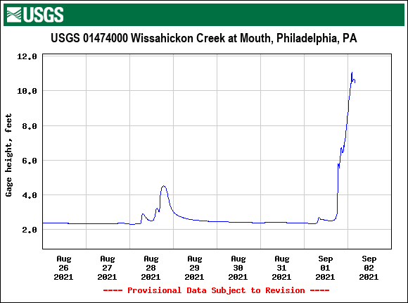
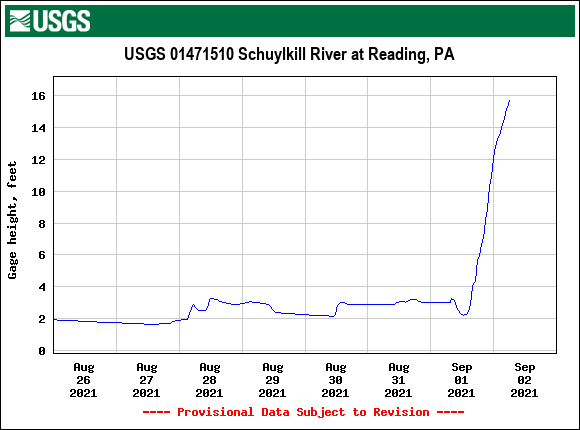
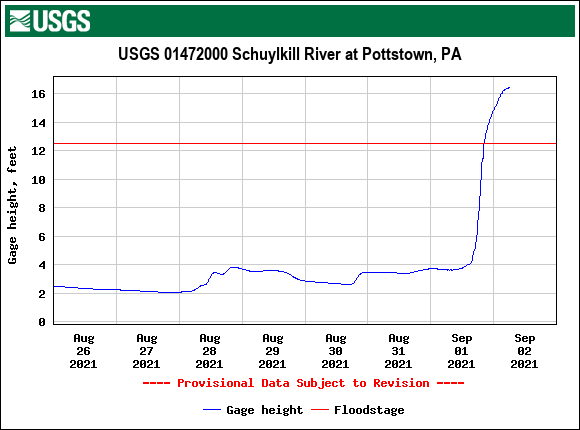
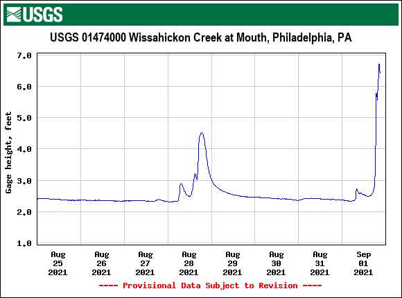
Still getting the light to moderate rain and am over that 5" mark (currently 5.05" total for today). Temp is down to 64 and there are now some city near stem creeks and rivers out of their banks! Schuylkill at Norristown flooding, Wissahickon has leveled off since it's probably completely covering Lincoln Drive. Schuylkill at the falls is just above flood stage and the Schuylkill at 30th St. is getting close to flood stage.
- 487 replies
-
- 1
-
-
- hurricane
- flooding potential
- (and 2 more)
-
I have had on and off heavy rain and am currently at 4.96" for the event with light rain (4.4" from round 2). The big news here is that the temp is down to 65 with dp 65, so definitely cooler and probably more stable here. Radar still has a back edge back in Lancaster County with what looks like some heavier returns further east so expect to get over the 5" mark at some point overnight.
- 487 replies
-
- 1
-
-
- hurricane
- flooding potential
- (and 2 more)
-
Those poor people up in North Jersey including the New Brunswick area have been getting the heaviest bands just raining over them for a couple hours.
- 487 replies
-
- 1
-
-
- hurricane
- flooding potential
- (and 2 more)