Hurricane Agnes
-
Posts
9,344 -
Joined
Content Type
Profiles
Blogs
Forums
American Weather
Media Demo
Store
Gallery
Everything posted by Hurricane Agnes
-
E PA/NJ/ DE Winter 2021-22 OBS Thread
Hurricane Agnes replied to JTA66's topic in Philadelphia Region
Not quite. -
E PA/NJ/ DE Winter 2021-22 OBS Thread
Hurricane Agnes replied to JTA66's topic in Philadelphia Region
Looks like some records may be challenged/broken Saturday, including record high mins - Currently 36 with dp down to 23. -
E PA/NJ/ DE Winter 2021-22 OBS Thread
Hurricane Agnes replied to JTA66's topic in Philadelphia Region
It's true! The mid-range "it's shifting north" / "it's shifting south" / "it's shifting east" / "it's shifting west" dance from run to run gets to be ridiculous. I like going by the long range "signal" and then will start my planning from there until nowcast time. The other stuff in between has become a lot of noise. Just listening to KYW this afternoon and hearing whoever it was doing the weather (may have been Brittney Shipp from NBC10) having to de-escalate the hype earlier in the week, was pretty painful. Sometimes surprises happen though and we get something that will "over-perform", so we'll have to wait and see what will actually happen tonight and tomorrow. -
E PA/NJ/ DE Winter 2021-22 OBS Thread
Hurricane Agnes replied to JTA66's topic in Philadelphia Region
This is something that I have observed not just this year, but for a number of years now. The LR seem to catch on to something that is interesting and will provide a good heads-up - whether it is some system or even some major temperature shift (whether a heat signal or cold signal). Then in comes the MR and excuse my language, when all is said and done, they suck ass for verifying. So you're left with the SR that although might not match exactly what the LR picked up on, eventually better nails the extent and timing, etc. It's like the MR tries too hard to do "what ifs" and goes for some of the most extreme solutions. Got down to 32 as a low this morning and am up to 41 and partly sunny with a deck of high clouds rolling in. The dp really crashed with the front, going from the mid-50s down to the low 20s and is currently at 24 here. -
E PA/NJ/ DE Winter 2021-22 OBS Thread
Hurricane Agnes replied to JTA66's topic in Philadelphia Region
Yeah that was a fast-moving sucker. Was right over top of me at 7:30 pm. Temp has finally started dropping, where I made it to 63 as a high after a 44 low. Currently 53 and falling with some light rain and 0.29" in the bucket and lots of wind whipping stuff around.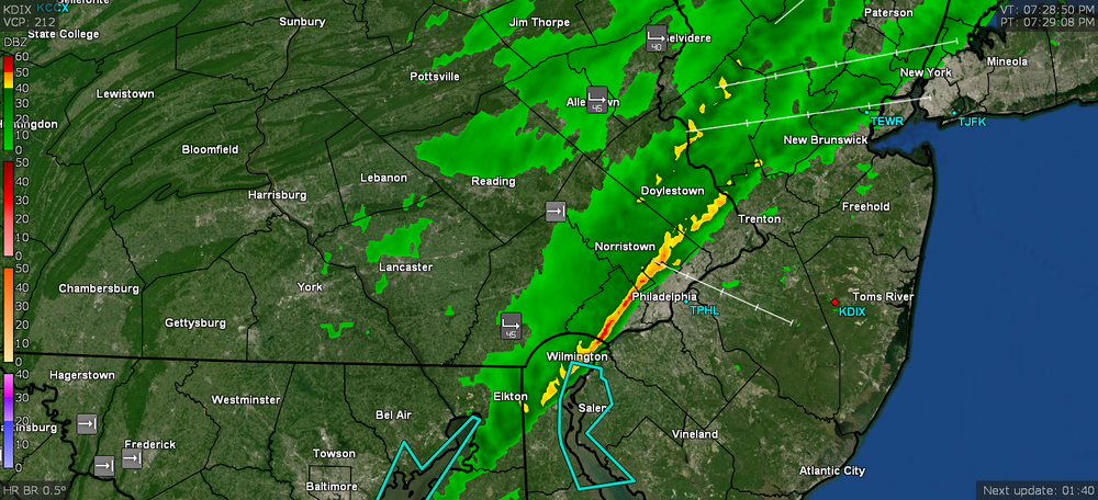
-
E PA/NJ/ DE Winter 2021-22 OBS Thread
Hurricane Agnes replied to JTA66's topic in Philadelphia Region
That's like what happens at the summit of Mt. Washington, NH every year. But then their tallest mountain on the big island - Mauna Loa (which is under the Warning) is like twice the height (at 13,679') of Mt. Washington (at 6,288'). Hawai'i has been in a drought so they are getting some beneficial rain elsewhere (although flooding too). -
E PA/NJ/ DE Winter 2021-22 OBS Thread
Hurricane Agnes replied to JTA66's topic in Philadelphia Region
Here's something that does happen but I know would irk the snow lovers - Meanwhile I had a low of 41 and it's currently mostly sunny and 48 with dp 30.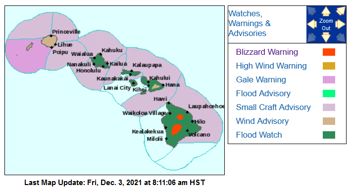
-
E PA/NJ/ DE Winter 2021-22 OBS Thread
Hurricane Agnes replied to JTA66's topic in Philadelphia Region
Need to put my 57 high/42 low obs here. Can't tell the seasons anymore! Currently 56 with dp 46 and partly cloudy (can see stars through breaks in the cloud deck). -
Went up to 57 here today after a low of 42. Got a couple hundredths of an inch of rain late last night this morning totaling 006" for the 2 days. I would say that the "traditional" met winter of DJF seems to have shifted to JFM, where we are getting "longer falls" but then "longer springs" on the back end, with AMJ being more "spring-like" due to more and more below-normal temps seemingly happening into June. That leaves a JAS as "summer" and OND as "fall". I guess technically the first day of winter (solstice) IS near the end of December so... Currently 56 with changeable skies (clearing to the west), with dp 46. Pretty nice out (I put the last of my outdoor decorations up).
-
Got some flurries yesterday and there are some going on here now. Had a low this morning of 26 and am currently at 40 with dp 30.
-
Finally saw my first flurries around 12:30 pm today. Lots of CAA going on complete with cumulostratus clouds. Had occasional breaks of sun earlier this morning but the cloud deck is a bit thicker now this afternoon. Temp is a breezy 41 with dp down to 27 now.
-
The below was intriguing from overnight. I expect it may have been virga though since the dews had dropped into the low 20s yesterday and overnight here. I did make it up to 47 after a low of 33. It's currently clouded up and 37 with dp 31.

-
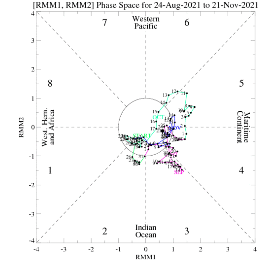
Ended up with a high of 52 yesterday and low of 47 - but my 51 high today came just after midnight as one front was about to come through, so the low is the current. The rain was a bit stingy (a line from last night basically evaporated as it approached) but I did get 0.10" this morning. Once the 2nd front came through, it sucked the moisture out of the atmosphere quite quickly. Did have stratocumulus obscuring the sun much of the day, although there were some breaks of sun. Currently 40 with a dp of 25. MJO Phase (90 days) FWIW -
-
Friday's low was 35 and yesterday's was a chillier 31, with the Friday high at 47 and yesterday's high 46. This morning was a bit surprising with some early fog and/or stratus (although with the temp/dp what they were and no wind between about 3 am - 5 am, I can see why)... but that has since lifted with a few puffs of wind. It's currently clear and and 37 with dp 36.
-
Hot damn! That front pushed the clouds and rain away and left a perfectly star-filled and moon-lit sky with the eclipse perfectly visible this morning! Yes the current temp is 40 (with dp a low 26) but was out there checking it out (between ~4:45 am - 5:15 am). ETA @6:42 am - from Mt. Holly -
-
After a low of 43 this morning, it's currently up to 69 with mostly blue sky. Saw the setting full moon through the window this morning knowing I won't be able to see it tonight with the incoming tempest. ETA - when I was out running errands earlier this morning, I took note that 1/2 of the trees are fully in leaf, although most of those have their fall colors. I know around here, the city would do their 2nd leaf removals (from the streets) around the first week of December and I definitely see why. It's possible that however gusty this incoming cold front gets, it might knock another batch of leaves down.
-
OMG. I remember when they were still WFIL and then changed to WPVI. Once the found a winning formula, the stuck with it and remained #1 for decades. Gardner was sortof the literal anchor for the various others who worked with him, including those who have come and gone over the years. Don Polec was a piece of work. I did just find this article from September where he got a kidney transplant last year (his condition was genetic) - https://6abc.com/gift-of-life-organ-transplant-don-polec-kidney/11041332/
-
Made it up to 48 yesterday after a low of 39, and although I had the same low this morning of 39, I'm already up to 60 at post time, so the warming trend is in place. Currently a new deck of clouds have moved in so it is mostly cloudy and 60, with dp up to 49, after having dps in the low-mid 30s the past bunch of days. Had to pull out the humidifiers today since the humidity in here had dropped down to the upper 20%s (not good). Finally got it back up to a reasonable 40%.
-
I did make it up to 48 today vs yesterday's high of 46. Lots of CAA and wind going on today and with a low of 36 this morning, and times of sun and clouds, am currently mostly cloudy with breaks in the cloud deck here and there, and 46, with dp 33.
-
That cold front meant some business and I bottomed out at 32 for a few hours after 3 am and am now up to 37, with frost, a dp of 31, and variable skies with lots of whispy cirrus obscuring the sun most times.
-
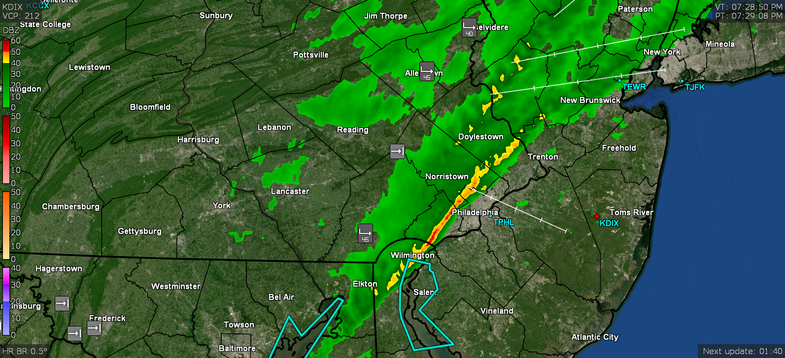
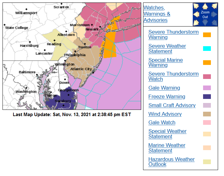
Back edge has blasted through and sun is out with clearing and blue sky overhead and to the west. Even with a couple minutes of the yellow over me at the end (image of closest approach below), I still got hardly anything. Currently 0.07". Temp down to 42 and dp 39. Mt. Holly just lofted a Wind Advisory.

-
Wow. Looks like the yellow band just dissolved away as it approached NW Philly. Maybe it broke up over the hills or something. Temp is now down to 43 with dp 40 and have 0.06" from it so far. Winds are still gusty.
-
Finally getting a little rain and so far have 0.02" in the bucket. Temp has plummeted to 46 with dp 44. Yellow band hasn't come through yet but getting real close now...
-
Gust front is coming through here at the moment and am getting a bit of a leaf-zard. Temp starting to drop quickly and down to 53 with dp 46. Still nothing in the bucket yet but there's a narrow line headed this way that might give me something.
-
All I know is that as waves started moving over me, I have been virga'd. Not a drop out of any of it although it has been breezy. So far my low has been 41 this morning and it's currently churning in the sky and 57 with dp 48. Looks like most of the action is north and east.