Hurricane Agnes
-
Posts
9,344 -
Joined
Content Type
Profiles
Blogs
Forums
American Weather
Media Demo
Store
Gallery
Everything posted by Hurricane Agnes
-
E PA/NJ/ DE Winter 2021-22 OBS Thread
Hurricane Agnes replied to JTA66's topic in Philadelphia Region
If that position of the low verified as shown, it would be a bit close to the coast and could cause mixing issues. -
E PA/NJ/ DE Winter 2021-22 OBS Thread
Hurricane Agnes replied to JTA66's topic in Philadelphia Region
The mood flakes that appeared here earlier evaporated with the 18 dp and temp at 31. Even the radar wiped the virga clean. Cloud deck is trying to brighten to the west.
-
E PA/NJ/ DE Winter 2021-22 OBS Thread
Hurricane Agnes replied to JTA66's topic in Philadelphia Region
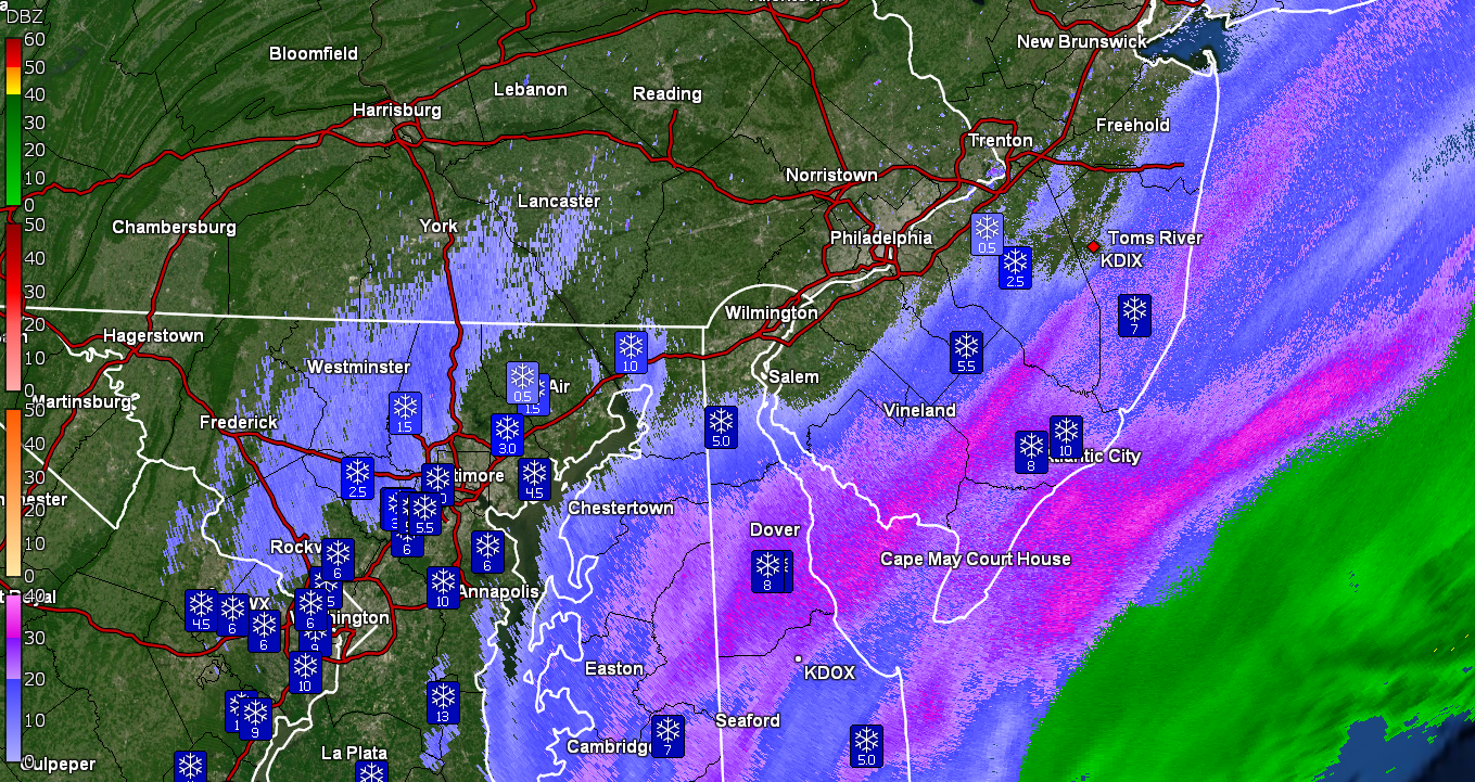
Now getting some hard-to-see mood flakes but they are there. temp 31 with dp 22. Heavier returns are slowing pushing northward. Spotter in Dunkirk, MD reporting 10".
-
E PA/NJ/ DE Winter 2021-22 OBS Thread
Hurricane Agnes replied to JTA66's topic in Philadelphia Region
Dp has dropped to 21 here with temp 31. Still virga at the moment. Looks like southern MD & eastern VA has reports of 6" - 7" already. Spotter in Absecon reporting 4.5" and someone at Somers Point reporting 5.5".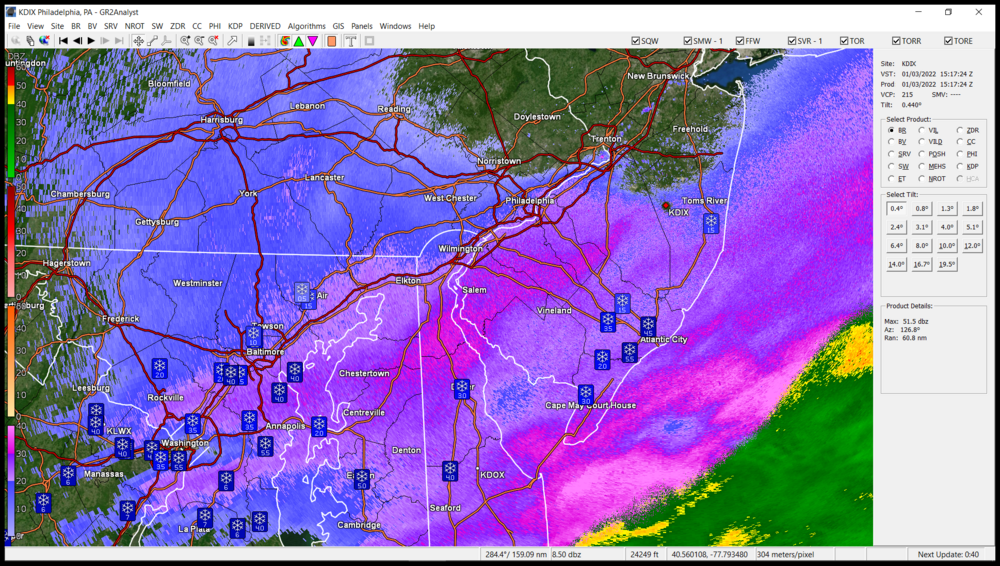
-
E PA/NJ/ DE Winter 2021-22 OBS Thread
Hurricane Agnes replied to JTA66's topic in Philadelphia Region
WPC's approx. (sat) position about 40 minutes ago, of the low that will go coastal soon - Temp holding at 31 IMBY with dp 23 so some dry air... -
E PA/NJ/ DE Winter 2021-22 OBS Thread
Hurricane Agnes replied to JTA66's topic in Philadelphia Region
Pancake flakes and nice breakers going on down there (plus it's a New Moon so some generally higher tides). -
E PA/NJ/ DE Winter 2021-22 OBS Thread
Hurricane Agnes replied to JTA66's topic in Philadelphia Region
Well the soon-to-be-coastal hasn't "coastaled" itself yet but once the low gets out there, there could be some wrap-around bands that pivot up here. Currently holding more at 31 now with dp 24.
-
E PA/NJ/ DE Winter 2021-22 OBS Thread
Hurricane Agnes replied to JTA66's topic in Philadelphia Region
Virga has evaporated here and it is overcast with temp bopping between 31 and 32 with dp 25. Far south Jersey and coastal DE looks to be getting rocked. The Carolina low is inching towards the coast but doesn't seem to be moving that fast. -
E PA/NJ/ DE Winter 2021-22 OBS Thread
Hurricane Agnes replied to JTA66's topic in Philadelphia Region
-
E PA/NJ/ DE Winter 2021-22 OBS Thread
Hurricane Agnes replied to JTA66's topic in Philadelphia Region
LOL @ Mt. Holly effusive AFD - Latest from Mt. Holly on forecast - It is a pretty presentation. Still have virga and temp is now down to 32 with dp 25.
-
E PA/NJ/ DE Winter 2021-22 OBS Thread
Hurricane Agnes replied to JTA66's topic in Philadelphia Region
I think everyone was waiting for your check-in. -
E PA/NJ/ DE Winter 2021-22 OBS Thread
Hurricane Agnes replied to JTA66's topic in Philadelphia Region
Virga here so far with temp 33 and dp 26.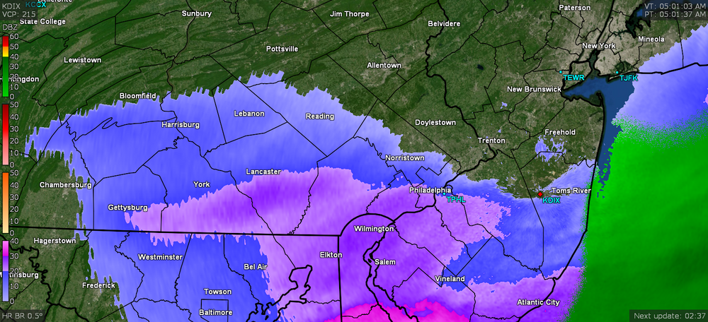
-
E PA/NJ/ DE Winter 2021-22 OBS Thread
Hurricane Agnes replied to JTA66's topic in Philadelphia Region
Currently 33 with dp down to 27 so conditions are ripe for something (although the ground is warm). Looks like Salem County and Newark, DE area under some heavier returns. -
E PA/NJ/ DE Winter 2021-22 OBS Thread
Hurricane Agnes replied to JTA66's topic in Philadelphia Region
If the eyes blend in with any flakage, then I'll SOL with finding a target. -
E PA/NJ/ DE Winter 2021-22 OBS Thread
Hurricane Agnes replied to JTA66's topic in Philadelphia Region
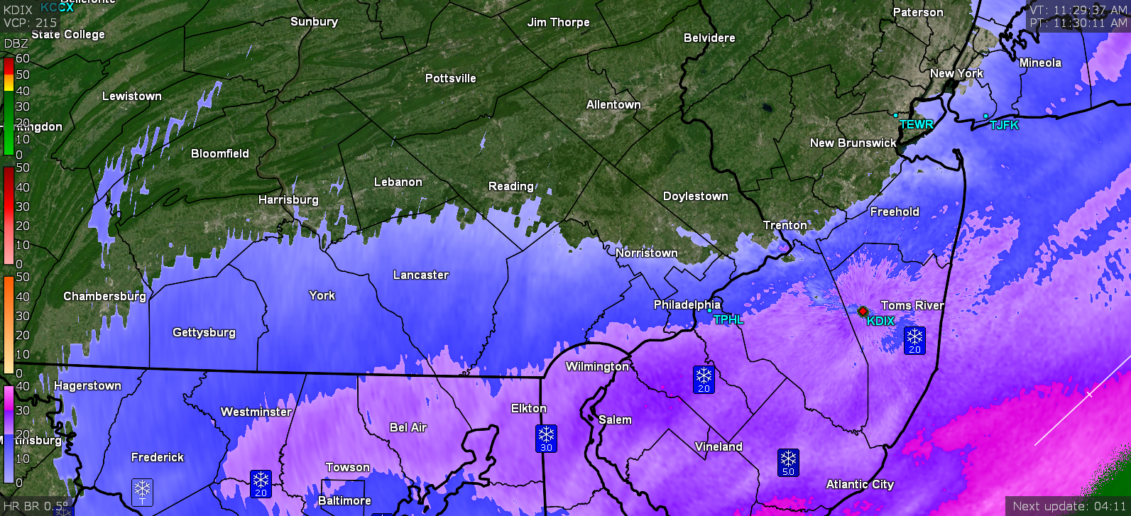
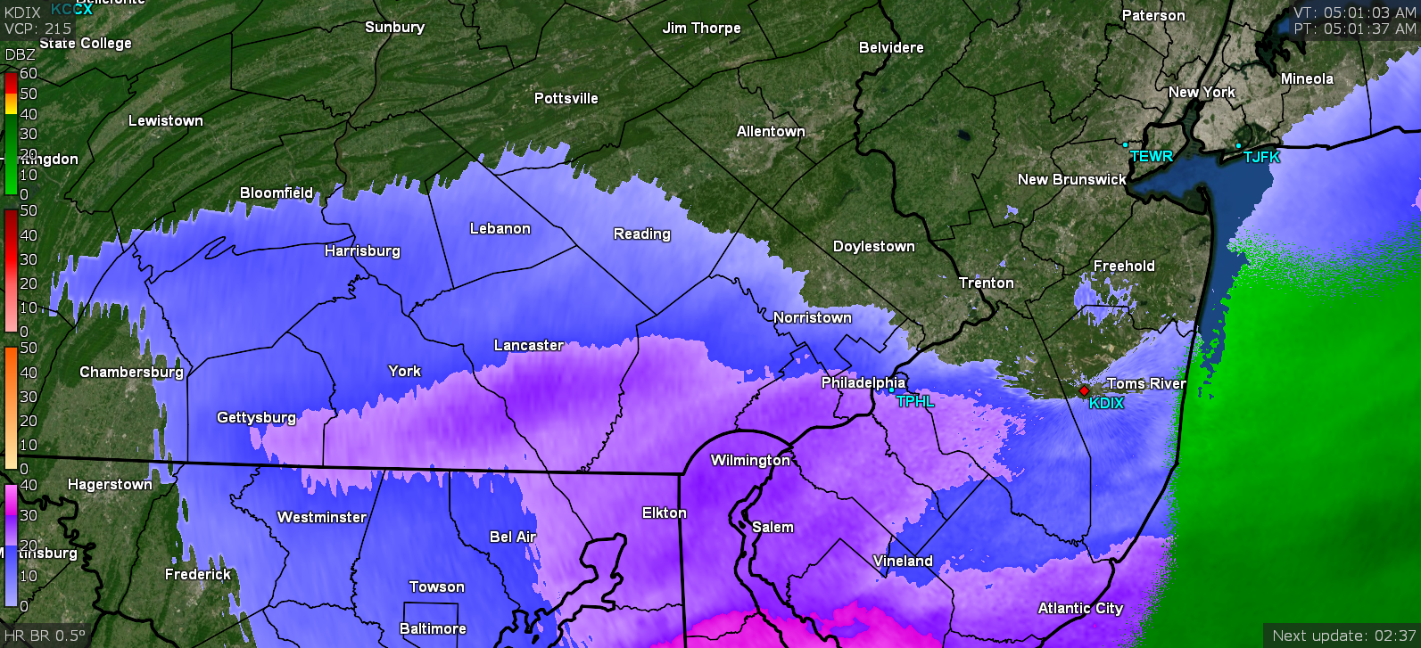
Getting a temp/dp drop and now down to 46 with dp 41. Here is what WPC posted about an hour ago - -
E PA/NJ/ DE Winter 2021-22 OBS Thread
Hurricane Agnes replied to JTA66's topic in Philadelphia Region
I was looking at -30F temps in the upper midwest this morning so that cold blob means some serious business. How far it oozes down with the jet and how dry it is, will make a difference where the gradient sets up. I wouldn't be surprised if there is some convection with it too in the southern parts of the CWA. -
E PA/NJ/ DE Winter 2021-22 OBS Thread
Hurricane Agnes replied to JTA66's topic in Philadelphia Region
Sorry had to weenie you. Haven't seen you in awhile. Nothing like the threat of snow to lay to rest the threats to merge our poor little forum. Currently 55 here with dp 51. ETA - I know people here are afraid to make an event thread lest they jinx it but... -
E PA/NJ/ DE Winter 2021-22 OBS Thread
Hurricane Agnes replied to JTA66's topic in Philadelphia Region
Gonna have to watch for dp depressions and how far south the subsidence from the north shears it away down here in Philly metro. It's still juicy out there at the moment. However we're not progged for anything until tomorrow morning's commute (I think peak) so unless the front speeds up, it'll be a watch and wait for the next 12 hours. -
E PA/NJ/ DE Winter 2021-22 OBS Thread
Hurricane Agnes replied to JTA66's topic in Philadelphia Region
Had a high of 60 so far today with changeable skies this afternoon (including occasional breaks of sun) after a low of 52. It's currently 59 with dp 54 and overcast. There are some spotty returns on the radar well ahead of the cold front. -
E PA/NJ/ DE Winter 2021-22 OBS Thread
Hurricane Agnes replied to JTA66's topic in Philadelphia Region
-
E PA/NJ/ DE Winter 2021-22 OBS Thread
Hurricane Agnes replied to JTA66's topic in Philadelphia Region
Mt. Holly just lofted the Warnings and Advisories - -
E PA/NJ/ DE Winter 2021-22 OBS Thread
Hurricane Agnes replied to JTA66's topic in Philadelphia Region
Here is the last tweet - -
E PA/NJ/ DE Winter 2021-22 OBS Thread
Hurricane Agnes replied to JTA66's topic in Philadelphia Region
Tradition for me growing up was to turn on the Mummers on New Year's Day and start dismantling Christmas - all stuff down and packed away on New Year's Day (which is what I did here yesterday although the rain postponed the parade until today... but the lights and wreaths were taken in very early before the rains started up). I kept some "seasonal" artificial plants around the house though. When I checked in here and saw there were 33 replies, I figured something was up and some legit threat had apparently been spotted. I could actually hear the Ji fireworks going off up here. Regardless, I ended up with 1.02" of rain for yesterday's total and have an additional 0.11" in the bucket this morning (total 1.13 for the 2-day event so far). Looks like the precip. is pretty much done for now though. Currently misty and 52 with dp 52. -
E PA/NJ/ DE Winter 2021-22 OBS Thread
Hurricane Agnes replied to JTA66's topic in Philadelphia Region
Have gotten heavy rain out of the band coming through (upwards of 1"/hr). This is probably the most in one event in awhile. Sure drought-buster. Currently moderate rain and 55 with dp 54 and 0.79" in the bucket.
-
E PA/NJ/ DE Winter 2021-22 OBS Thread
Hurricane Agnes replied to JTA66's topic in Philadelphia Region
Okay. Thank you for clarifying the range because I know last year with La Nina, it was whacked out and I expect with the stronger Nina this year, it might still be whack until deeper in the season .