Hurricane Agnes
-
Posts
9,344 -
Joined
Content Type
Profiles
Blogs
Forums
American Weather
Media Demo
Store
Gallery
Everything posted by Hurricane Agnes
-
I don't think they were even forecasting it that low by that Saturday. I remember earlier in the week some 1" - 3" estimates but as we approached that weekend, the forecast had been gradually increasing until it was up to at least 3" - 5", then I think 6" - 8" by the Friday/Saturday timeframe. I watched the classic TWC coverage that weekend where TWC kept adding more and more colors to their snow map that Saturday, Sunday and Monday, literally doing "real-time" / "on the fly" nowcasts. Someone posted a video of TWC (a Wilmington feed which is within our CWA) with the current conditions/forecast late Saturday afternoon (where the Winter Storm Warnings were already up) - Someone else posted a Baltimore feed of TWC (Sterling CWA) with the same storm coverage but now picking it up from around 9 am Sunday, where the Blizzard Warnings were already up -
-
January 7th First Snow for some N&W folks Discussion
Hurricane Agnes replied to ChescoWx's topic in Philadelphia Region
I calculated the snow water equivalent (at least down here in Philly) as 18:1 (doing a melt from what was collected in my Stratus). And with the wind, dry arctic air, and dews in the low teens or less (I'm currently down to a dp of 12), much of the snow pack has been blowing around, and that means sublimation can come into play (even with temps below freezing), literally "evaporating" the snow (i.e., the water goes right from solid to gas in the bright sun). I agree with the issues of scouring out that built-up cold air being a tall order. Will have to see how much of a warm nose happens Sunday (and where in the atmosphere it oozes in). -
E PA/NJ/ DE Winter 2021-22 OBS Thread
Hurricane Agnes replied to JTA66's topic in Philadelphia Region
With the sun having set, the temps and dps are dropping and I'm currently down to 26 with dp 14. It has still been breezy though so if that continues through the night, even if lightly, then may not get ideal radiational cooling. -
January 7th First Snow for some N&W folks Discussion
Hurricane Agnes replied to ChescoWx's topic in Philadelphia Region
Until the power goes out. I'm a bit concerned about the antecedent cold leading into Sunday and any initial precipitation freezing everywhere on contact before it starts melting and warming surfaces. The powdery snow down here may be mostly dissolved away depending on what happens tomorrow for a high and with any initial rain onset Sunday. I have a "Polarshield" cover thingy on my car windshield right now that I will probably leave on through that event. -
January 7th First Snow for some N&W folks Discussion
Hurricane Agnes replied to ChescoWx's topic in Philadelphia Region
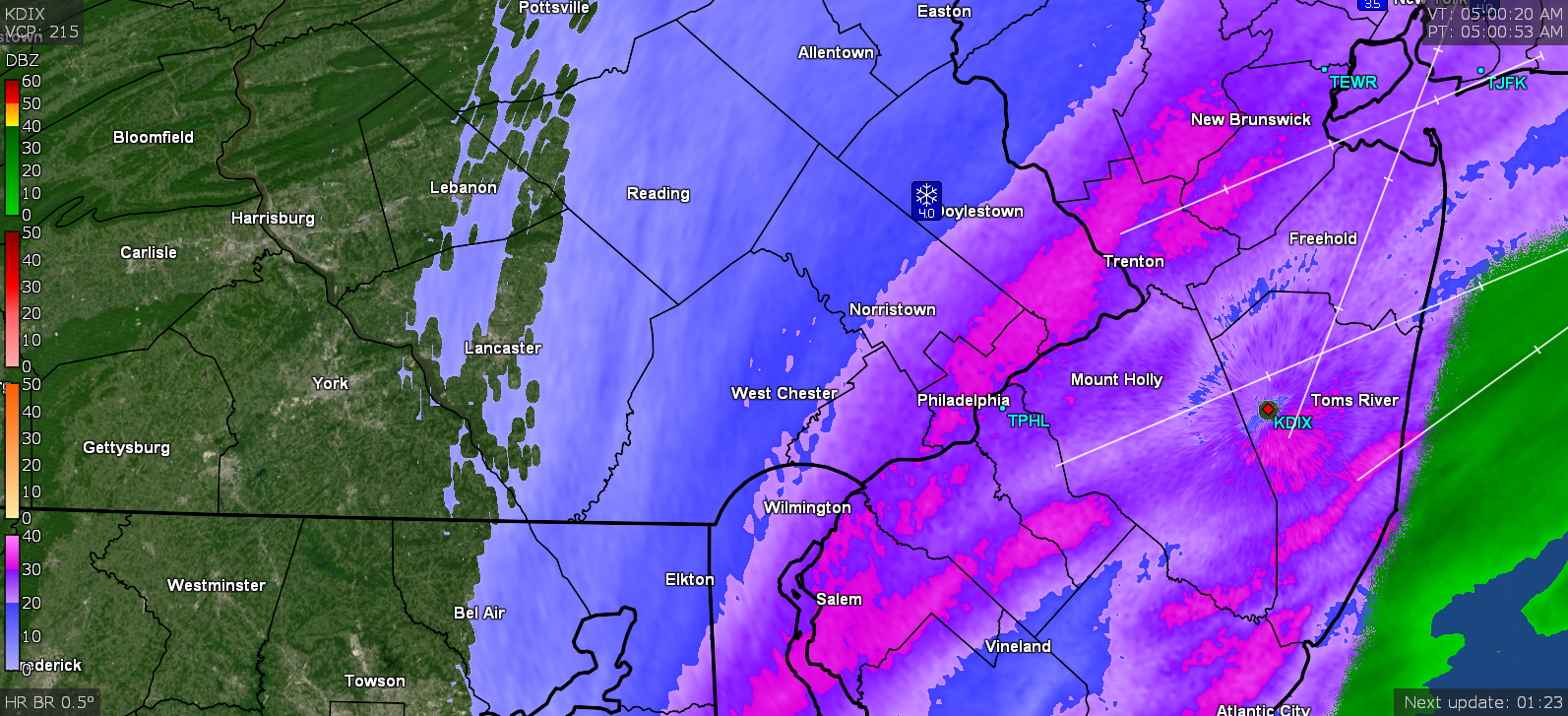
Mt. Holly tweeted out a cool sat picture of the aftermath. You can even see some of the "snow holes". -
E PA/NJ/ DE Winter 2021-22 OBS Thread
Hurricane Agnes replied to JTA66's topic in Philadelphia Region
MJO progged (by GFS and its ensembles) to (at least briefly) get into Phase 8 around that time).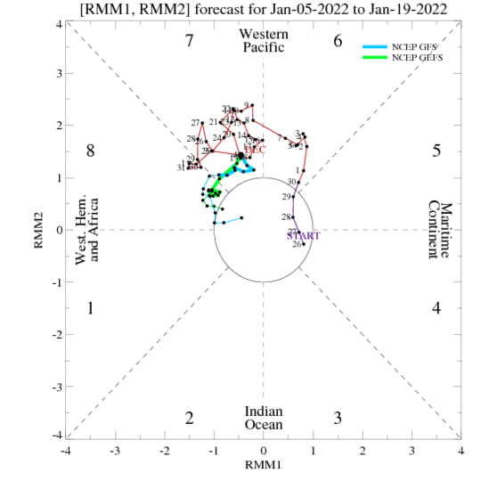
-
January 7th First Snow for some N&W folks Discussion
Hurricane Agnes replied to ChescoWx's topic in Philadelphia Region
The Profile offers a field to include a "Location" and literally everyone in this thread (other than one person who did an obs from wherever they were) has something in there except you. I just got in from clearing the snow off my SUV (big job thankfully handled very well with the use of a big new Christmas present - an extendable 60" snow broom/brush/scraper that did a good job clearing the lightweight snow). Lots of powder blowing around out there and am still warming the poor fingers (the isontoner gloves are good for driving but probably needed something warmer for what I just did). Currently changeable skies and still holding at 29 but dp continues to drop and is bopping between 18 and 19. -
January 7th First Snow for some N&W folks Discussion
Hurricane Agnes replied to ChescoWx's topic in Philadelphia Region
From the 11:02 am PNS - Will have to see if the Freehold spotters have any additional measurements to report in the next publication since it would have still been going there at the listed times (West Freehold is SE of Freehold). -
January 7th First Snow for some N&W folks Discussion
Hurricane Agnes replied to ChescoWx's topic in Philadelphia Region
I had posted this in obs but re-posting here on the SWE calculated from the Stratus gauge collected snow - -
E PA/NJ/ DE Winter 2021-22 OBS Thread
Hurricane Agnes replied to JTA66's topic in Philadelphia Region
Did bring the Stratus in to get a water equivalent from what was collected in it (sometimes I'll do a core sample but there wasn't much wind out there overnight). Planned to add warm water to melt it faster once I brought it in but it had almost melted after about 15 minutes inside (but I still added some to get the rest of it finished off) and came up with a 18:1 ratio which makes sense considering how dry it was doing the depth measurement and how fast it had disintegrated in the outer cylinder even before adding anything. Currently overcast again and up to 29 with dp 21. -
January 7th First Snow for some N&W folks Discussion
Hurricane Agnes replied to ChescoWx's topic in Philadelphia Region
First round of PNSes were posted - -
January 7th First Snow for some N&W folks Discussion
Hurricane Agnes replied to ChescoWx's topic in Philadelphia Region
Sun now clearly breaking through what is left of the cloud deck and the snow is done. Temp is 27 with dp now down to 25. Seems south central PA (York/Lancaster counties) and areas south and west of there really cashed in with their own blob of snow-producing moisture. -
January 7th First Snow for some N&W folks Discussion
Hurricane Agnes replied to ChescoWx's topic in Philadelphia Region
(sorry had to - old local Philly jazz group who made it big and is still big and did that song - a nod to the Moses Malone prediction of the '83 Sixers Championship playoffs sweep with a 4-4-4 that actually ended up being 4-5-4 ) Philadelphia's number (and yes the city had one) was never really mentioned but was still "officially" designated as "100" but they would just blanket say "All Philadelphia Public and Parochial Schools are closed" (lumping the Catholic schools in because they usually mirrored each other with the snow closures). Now that phrase has changed with the latter part using "Archdiocesan schools". -
January 7th First Snow for some N&W folks Discussion
Hurricane Agnes replied to ChescoWx's topic in Philadelphia Region
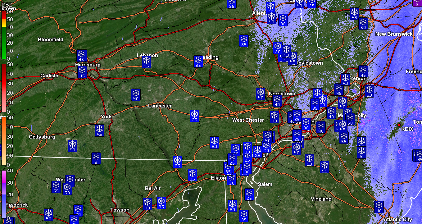
Odd set of accumulations and it's tricky to find the gradient although some of the areas that got under a band can be deduced.
-
January 7th First Snow for some N&W folks Discussion
Hurricane Agnes replied to ChescoWx's topic in Philadelphia Region
Just measured a few places on my board and got 4.5". I have my Stratus out there (without the inner calibrated tube and top) so if I feel up to it, I may try to get a water equivalent of the snow - it seems pretty light and powdery). Currently clearing with some SN-- (can see some scattered cirrostratus through a lower deck of clouds that are breaking up in the east) and 27 with dp 26. -
January 7th First Snow for some N&W folks Discussion
Hurricane Agnes replied to ChescoWx's topic in Philadelphia Region
Down to SN- now and am ball-parking almost 4" (the last burst certainly helped) but will need to wait a bit until it's light out to measure it on the board. Currently still 28 w/27 dp. -
January 7th First Snow for some N&W folks Discussion
Hurricane Agnes replied to ChescoWx's topic in Philadelphia Region
I have a little nephew in 2nd grade who is off for a snow day too (they were doing virtual part of last school year so am guessing it would have been do-able). Hell here in Philly, we had to have a forecast of at least 6" to get a snow day. -
January 7th First Snow for some N&W folks Discussion
Hurricane Agnes replied to ChescoWx's topic in Philadelphia Region
Looks like I got under a more intense band right at 5 am. Still 28 with dp 27 and SN.
-
January 7th First Snow for some N&W folks Discussion
Hurricane Agnes replied to ChescoWx's topic in Philadelphia Region
Ditto - just got under a heavier band and am at least SN and rising.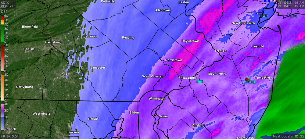
-
January 7th First Snow for some N&W folks Discussion
Hurricane Agnes replied to ChescoWx's topic in Philadelphia Region
Exactly! There were days when they would take almost the whole 30 minutes on KYW reading off school numbers, county by county, in 3 states (including those who were closed or had delayed openings). Now it seems the suburban schools do robocalls/texts/email blasts and some of the local stations will have a list on their websites. Philly public and Archdiocesan schools do get the KYW closure mention that takes like 5 seconds. Currently 28 w/dp 27, somewhere between SN- and SN with some fog. -
January 7th First Snow for some N&W folks Discussion
Hurricane Agnes replied to ChescoWx's topic in Philadelphia Region
Mt. Holly giving a nod to the "earlier risers" (IOW the too excited to go to bedders ) - That far western part of the CWA and their cash-in didn't seemed to be progged but I did see where they got a WSW upgrade. -
January 7th First Snow for some N&W folks Discussion
Hurricane Agnes replied to ChescoWx's topic in Philadelphia Region
Woke up around 2 am to look out and saw SN+. Looks to be almost 2" now and SN, with temp 28 with dp 27.
-
January 7th First Snow for some N&W folks Discussion
Hurricane Agnes replied to ChescoWx's topic in Philadelphia Region
La Nina winter, although we didn't do too badly last year with one (but this year's is a bit stronger). Once the pattern flips, we'll be like Denver (typically) with "spring snow". -
January 7th First Snow for some N&W folks Discussion
Hurricane Agnes replied to ChescoWx's topic in Philadelphia Region
I think as long as you have an Eagles avatar (Nick Foles I think), you know where you must go! -
January 7th First Snow for some N&W folks Discussion
Hurricane Agnes replied to ChescoWx's topic in Philadelphia Region
I defaulted to that being on and those are mPINGS - https://mping.nssl.noaa.gov/ Am guessing that Radarscope just grabs that data to include in their radar datasets.