Hurricane Agnes
-
Posts
9,344 -
Joined
Content Type
Profiles
Blogs
Forums
American Weather
Media Demo
Store
Gallery
Everything posted by Hurricane Agnes
-
E PA/NJ/ DE Winter 2021-22 OBS Thread
Hurricane Agnes replied to JTA66's topic in Philadelphia Region
You may have to host it somewhere and link to it or find a way to shrink/compress the size (maybe get it down to a lower resolution or edit it to run for a shorter amount of time). I know the different subscriptions here offer different file sizes permitted for each upload. -
E PA/NJ/ DE Winter 2021-22 OBS Thread
Hurricane Agnes replied to JTA66's topic in Philadelphia Region
You guys made me get up and check and there be white pancakes coming from the sky! Temp at 37 but dp is up to 30 so the atmosphere has moistened enough to kill the virga.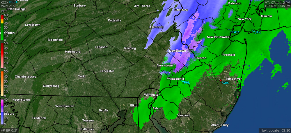
-
E PA/NJ/ DE Winter 2021-22 OBS Thread
Hurricane Agnes replied to JTA66's topic in Philadelphia Region
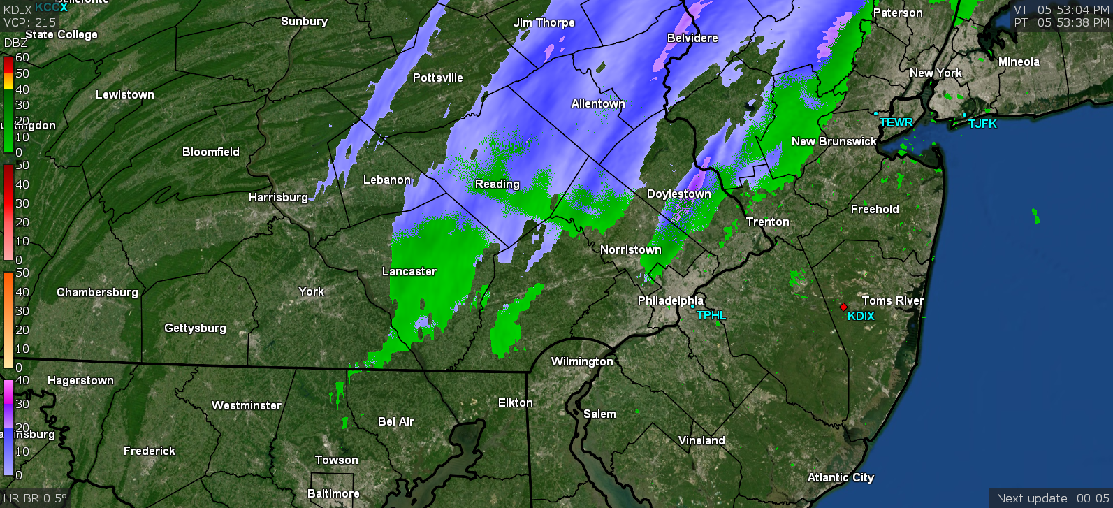
Looks like upper Bucks got under something. Grabbed a snapshot of a heavier band not far from you... RedSky should be under some good stuff. It's too warm here (am at 37, although the dp is now up to 29).
-
E PA/NJ/ DE Winter 2021-22 OBS Thread
Hurricane Agnes replied to JTA66's topic in Philadelphia Region
That's not how they do "normal" temperatures. The climatology to determine what is "normal" is done over a period of many years. They may report out an "average" temp for the day as a somewhat meaningless stat, but they generally average the daily highs for each season over some period of years, and then do the same for the lows, and with that in hand, can come up with what might be considered typical ("normal" ). Similarly, USDA had been calculating their hardiness zones by averaging the lowest min winter temperature for each year over a period of from 15 - 30 years for different regions of the country and will then assign hardiness zones based on that to give gardeners some idea for what types of plants (trees, shrubs, etc) can be grown in different areas and have a good chance to survive the lowest temps (the zones designated on a 10 degree scale). -
E PA/NJ/ DE Winter 2021-22 OBS Thread
Hurricane Agnes replied to JTA66's topic in Philadelphia Region
Just a couple weeks too soon. -
E PA/NJ/ DE Winter 2021-22 OBS Thread
Hurricane Agnes replied to JTA66's topic in Philadelphia Region
So you did see something crystalline fall from the sky that wasn't something like ashes flittering your way from someone's fireplace. Meanwhile the sun has busted out here through an eroding deck of high clouds. Temp is up to 39 and dp is 25. -
E PA/NJ/ DE Winter 2021-22 OBS Thread
Hurricane Agnes replied to JTA66's topic in Philadelphia Region
It's a shame that I didn't think to pull up my GR2Analyst (on a different laptop) to get a finer resolution from the Level 2 data to see if I could capture that time frame. Definitely won't rule out a mass exodus of starlings or those damn Canada geese (although if it were them they might have ended up on this side of the river)! -
E PA/NJ/ DE Winter 2021-22 OBS Thread
Hurricane Agnes replied to JTA66's topic in Philadelphia Region
I've seen radar captures of sudden bird (or even insect) migrations. But this seemed to also cover a broader area in addition to what was centralized near Mt. Holly. Was looking again at the radar and a map again and it's possible there was something going on at Joint Base McGuire–Dix–Lakehurst (looks like that is probably what is closest to where that blew up). -
E PA/NJ/ DE Winter 2021-22 OBS Thread
Hurricane Agnes replied to JTA66's topic in Philadelphia Region
I remember years ago before coming to this site, when there might have been a signal like that because we ended up with a sleet storm on Christmas Eve and I remember driving my mom to church services for the evening mass. -
E PA/NJ/ DE Winter 2021-22 OBS Thread
Hurricane Agnes replied to JTA66's topic in Philadelphia Region
Looks like it all but evaporated here although there appears to be a virga band over RedSky. Temp was holding at 35 but just edged up to 36 with dp 26. Checked the MA forum and aside from the there doesn't seem like much more than virga going on down there either. -
E PA/NJ/ DE Winter 2021-22 OBS Thread
Hurricane Agnes replied to JTA66's topic in Philadelphia Region
One of my sisters who lives in Upper Darby texted that she is getting some stray flakes down her way. Still not seeing anything here. Dp is definitely creeping up though and am up to 26. -
E PA/NJ/ DE Winter 2021-22 OBS Thread
Hurricane Agnes replied to JTA66's topic in Philadelphia Region
The leading edge has been over me and am not seeing anything but virga too. It feels like "snow" out there though but temp is now up to 35 here, with dp still sticking to 24/25. -
Had been reading about that last year. You will surely live vicariously through your son. Will be interesting to see how the rain/wind sensors perform and verify over the long haul. Something you might want to also get is a Stratus (manual) rain gauge for the heck of it to see how close the Tempest's values are with it.
-
E PA/NJ/ DE Winter 2021-22 OBS Thread
Hurricane Agnes replied to JTA66's topic in Philadelphia Region
LOL that is an interesting thought, although I would think something like that would show up as small blobs of green on the radar. These looked almost like those scattered pop-up thunderstorm cells that we see in summer. -
E PA/NJ/ DE Winter 2021-22 OBS Thread
Hurricane Agnes replied to JTA66's topic in Philadelphia Region
I just peeped out and am not seeing anything yet, although that band to the west is not over this area either (it would probably need that lobe from the high to move further east). In any event, it's currently overcast and 34 with dp still lowish at 24. -
Attention All Philly Subforum Members
Hurricane Agnes replied to Rjay's topic in Philadelphia Region
Who is "you"? I don't come here to get into silly arguments with people about what the models are claiming. I mostly read, post obs and will add some interesting supporting info about what the weather is doing. I recently retired (almost 5 years ago) and fortunately now have more time to read through the posts here while working on my weather station (and data that I am gathering while configuring/tweaking the weewx app to have a local webpage displaying that data). I actually follow tropical systems and on occasion have posted in that subforum during some of the biggies, although recently have been tracking remnants of systems that come through this area. I think you might be mistaking the "quiet" posting without the knock-down drag out trolling, for "lack of interest". If you believe that a raucous discussion is the only type that is "acceptable" then that is your opinion but I find it distracting when trying to absorb new info on how to approach forecasting. I'm just not getting what the problem is. I know there were issues way in the past that apparently had to do with some moderators, and that caused a bunch of folks to go off and create a new site, but that has nothing to do with the people who continue to post and contribute here. In any field, there will always be "differences of opinion" and I think the lay public would be shocked that this even happens in the science fields but it most certainly does (I was a chemist so I know arguments ensue about what certain data actually "means"). Oddly enough, the way the climatology is in this area based on how the jet stream ebbs and flows, we are often right under a flow that puts this area in marginal weather territory, with occasional spikes of extremes. But it makes it inherently "different" and unique from other areas - particularly with the topography (e.g., the Piedmont vs the coastal plain), but then that also tends towards us having more "boring" weather. There was a reason many centuries ago people settled in this area and that was because of a more stable, truly "temperate" weather pattern - particularly good for agriculture. I don't have a problem with people from other subforums "popping in" - in fact during big events, they often do. And I really haven't seen any rancor when they do come in and interact/contribute as events unfold. As I posted elsewhere, if Randy and crew feel they want to further revise this site and consolidate the subforums, they are obviously going to do it regardless of what we think in some "poll", and will have their own reasons. But to continue to come here and stir a pot is just non-productive. -
E PA/NJ/ DE Winter 2021-22 OBS Thread
Hurricane Agnes replied to JTA66's topic in Philadelphia Region
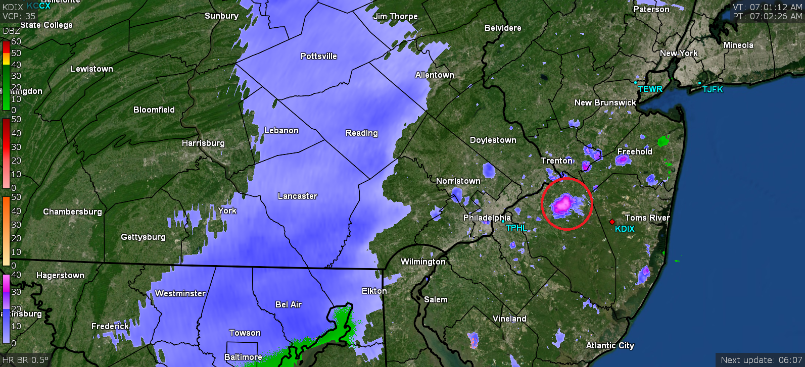
I someone in Jersey getting a sudden flizzard? ETA - was looking on a map and that is appearing in an area near Mt. Holly. Could be Mike fired up the snow-making machine.
-
E PA/NJ/ DE Winter 2021-22 OBS Thread
Hurricane Agnes replied to JTA66's topic in Philadelphia Region
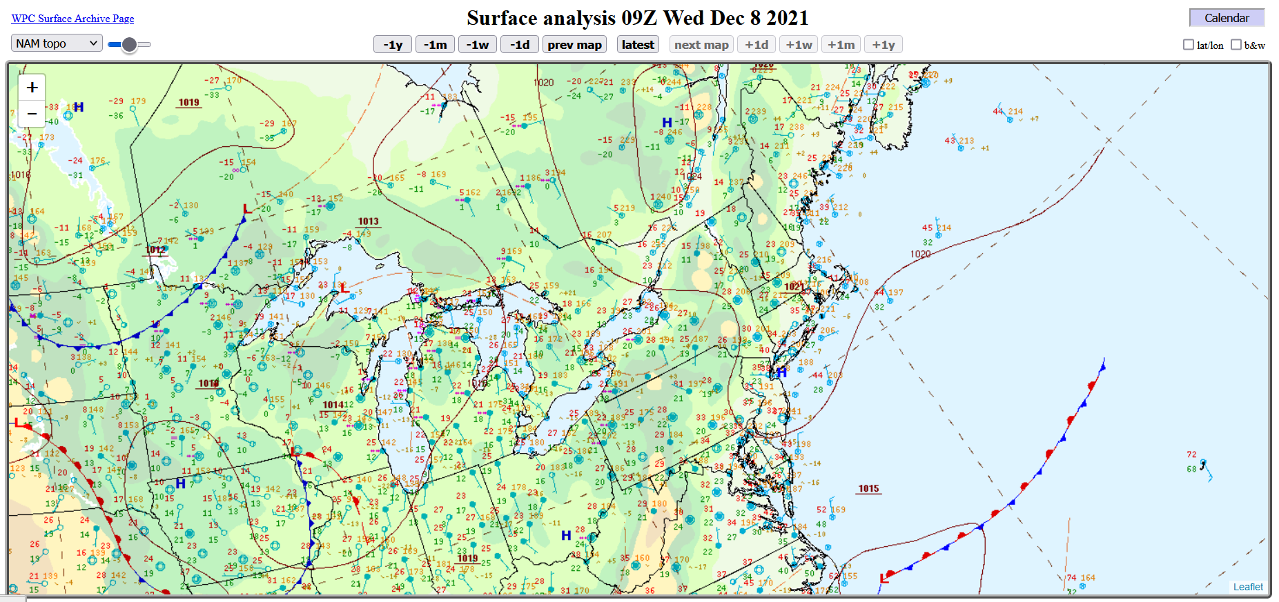
Yup. I am on a Nextdoor list and people were posting that helicopters have been flying over the area overnight. That band seems to have hit a wall. WPC's current surface map sortof shows why!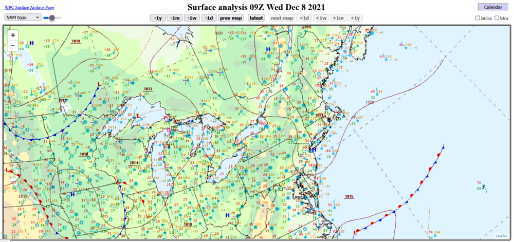
-
E PA/NJ/ DE Winter 2021-22 OBS Thread
Hurricane Agnes replied to JTA66's topic in Philadelphia Region
I heard about the car theft with the little girl in it on KYW this morning although the location they mentioned in their report was completely bollixed - it's not "56th and Green" but the 5600 block of Greene St. (I know exactly where that is - not far from Greene and Chelten Ave). I've been watching that band get sheared apart on and off early this morning although it seems to have finally held together better now. The dp here is 24 so not sure how much of it will survive beyond producing virga but will see. Temp is marginal here at 33. -
Attention All Philly Subforum Members
Hurricane Agnes replied to Rjay's topic in Philadelphia Region
Exactly. There hasn't really been a need, even with a handful of disruptive posters who although annoying, have not risen to the level of banning (at least yet). IMHO, if Randy and crew feel it's time to revise the site further and consolidate the subforums, then they are perfectly within their right and position to do so immediately, whether we want it or not, and we just roll with whatever they decide. -
Attention All Philly Subforum Members
Hurricane Agnes replied to Rjay's topic in Philadelphia Region
Why is this brought up every year? Is there some kind of boredom going on elsewhere that coming in here to insult how things are discussed becomes a "thing"? It's just idiotic. I pay a premium yearly membership to post and upload stuff here and enjoy my hobby and banter and grabbing links to all kinds of sites that I can peruse to participate in discussions. What chaps my hide is the abject trolling that goes on in here from people who seem intent on eliminating this group... and for what reason, I have no idea. If anything, this is a place where at least the moderators don't have to continually spend all their time removing weenie and troll posts. This group encompasses the Mt. Holly CWA. NYC/SNE is not part of the Mt. Holly CWA and neither is the MA group. -
E PA/NJ/ DE Winter 2021-22 OBS Thread
Hurricane Agnes replied to JTA66's topic in Philadelphia Region
Seems something like at least a 66 is pretty much unanimous across the different weather media outlets/sites as a high, and would be enough. What will be interesting to see if there is a record high min. Was digging around trying to find what that was... -
I have an Ambient WS-2000 that is replacing my old beat-up WS-1001. What's nice about it aside from it giving the option to easily connect to and upload to both WU and Ambient's websites, are the multitude of sensors that the console can handle including up to 8 temp/humidity sensors, I think 2 Particulate Monitors (indoor/outdoor & indoor only), up to 8 soil moisture meters (plus probed ones), a leak detector, and my fave - a lightning detector - https://ambientweather.com/amws2000.html I actually had seen something posted on a different weather forum where a temp/humidity sensor was being used in a deep freezer and I decided to try that with one of mine. It was definitely a great idea because now I don't have to actually go down to the basement and periodically open the thing up to look at the temp on the analog one that I stuck in there to see how it cycles the temps! There is a cheaper model - the WS-2902C that can have up to 8 temp/humidity sensors - https://ambientweather.com/amws2902.html I *think* the base units are the same but the consoles are different which is reflected in the price differential. These are "all-in-one" units that do temp/humidity/wind speed/direction/solar radiation/uv index/precipitation (liquid) and the sensor that goes inside does the pressure and indoor temp. It has a passive radiation shield over the outdoor temp sensor but it seems to do the job okay (at least where I have mine sited about 7 ft up on a mast attached to a privacy fence post) without sudden temp spikes or drops with the sun movement.
-
E PA/NJ/ DE Winter 2021-22 OBS Thread
Hurricane Agnes replied to JTA66's topic in Philadelphia Region
They should save it for March as it seems we get more backend-of-winter stuff when people are ready for spring to come. I know that Cheltenham and Springfield Townships in Montco are usually out there brining but I didn't get out today to see... -
E PA/NJ/ DE Winter 2021-22 OBS Thread
Hurricane Agnes replied to JTA66's topic in Philadelphia Region
I don't think I've ever seen the "average temperature" be considered the "normal temperature".