

TheClimateChanger
-
Posts
4,593 -
Joined
-
Last visited
Content Type
Profiles
Blogs
Forums
American Weather
Media Demo
Store
Gallery
Everything posted by TheClimateChanger
-
Interesting observation.
-
Pittsburgh, Pa Summer 2024 Thread.
TheClimateChanger replied to meatwad's topic in Upstate New York/Pennsylvania
Has reached at least 87F at PIT today, so far. Still looks like it will be a close one right on the cusp of 89/90. It is pushing/reaching 90 in the western parts of the county warning area (HLG, PHD & ZZV) where there was less rainfall in recent days.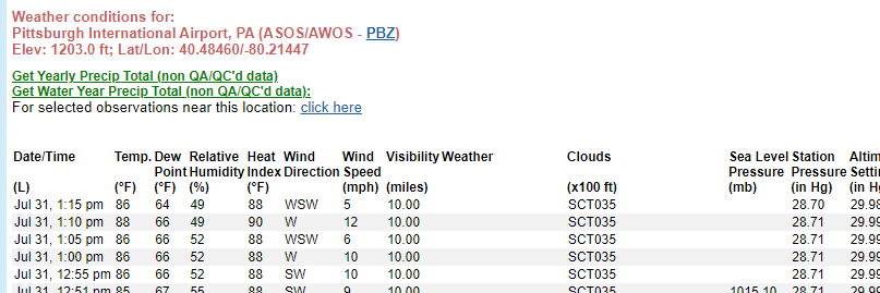
-
Pittsburgh, Pa Summer 2024 Thread.
TheClimateChanger replied to meatwad's topic in Upstate New York/Pennsylvania
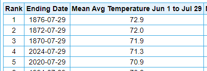
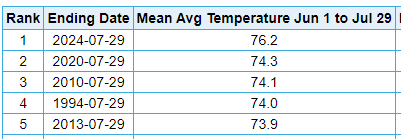
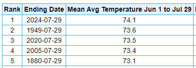
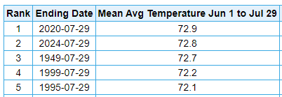
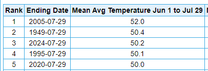
As far as the allegation of manipulation to this data made by a certain poster or posters (not here). I find little evidence of any sort of systematic cooling of the past and warming of the present, which is the allegation frequently made. Admittedly, they are slightly different, but not in a way suggesting some sort of manipulation. In fact, if you look at NCDC, you'll see the divisional averages for July 1988, 1998 and 2022 for the Southwest Plateau division of Pennsylvania are all somewhat lower from what was reported in the monthly climate review publication. Now given as 73.4F (-0.3F), 69.7F (-1.1F), and 72.0F (-0.9F), respectively.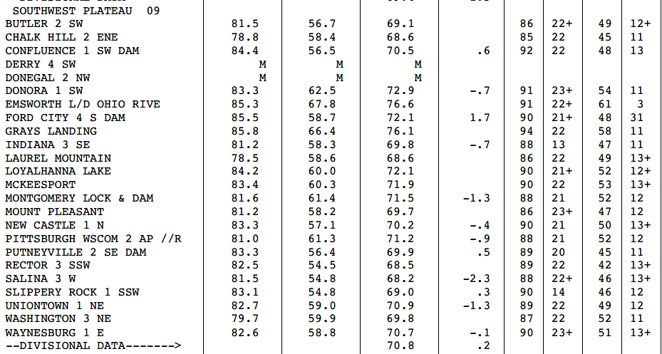
-
Pittsburgh, Pa Summer 2024 Thread.
TheClimateChanger replied to meatwad's topic in Upstate New York/Pennsylvania
Just compare the PIT mean to the divisional average in 1988. 76.9F versus a divisional average of 73.7F (+3.2F). In 1998, a very typical July around western Pennsylvania. You'll see it was still in the 50s in most places. But PIT was only 0.4F warmer than the divisional average. In the interest of full disclosure, you'll see it's started to widen again in recent years. July 2022, for instance, saw a mean of 74.2F at PIT versus a divisional average of 72.9F (+1.3F). But that probably reflects a growing UHI effect in the area.
-
Pittsburgh, Pa Summer 2024 Thread.
TheClimateChanger replied to meatwad's topic in Upstate New York/Pennsylvania
Hey, I don't lie when I say the thermometer at PIT was garbage then. Almost like the "urban heat island" became smaller over time. -
Pittsburgh, Pa Summer 2024 Thread.
TheClimateChanger replied to meatwad's topic in Upstate New York/Pennsylvania
More shenanigans. Erie, PA... in 1988, the normal July temperature was considered to be 69.1F. Today, it's 72.7F, an absurd 3.6F (2C) warmer. Which is a massive change for a low variability summer month over 3 decades. Literally, a normal July in Erie today would have been considered a very hot July just 35 years ago. Let that sink in. A normal August at Erie is now 2.4F warmer than a normal July was just a little over 30 years ago, and a normal June less than 1F cooler. The normal low temperature for July is now just a handful of degrees cooler than the normal mean temperature just a little over 30 years ago. And most recent Julys have had mean low temperatures just 2-3F cooler than the normal mean of 1990. Absolutely bonkers. Sorry for the rants.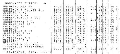
-
Pittsburgh, Pa Summer 2024 Thread.
TheClimateChanger replied to meatwad's topic in Upstate New York/Pennsylvania
I'm gonna say no. If you look at data from the 1980s and 1990s, outside of the heat island, it routinely dropped into the 50s on the majority of July nights in western Pennsylvania. Now you get a handful of days in the 50s. There's a lot of gaslighting about this from some, blaming it all on UHI. But if you look at the actual data, you'll see the UHI has always existed. Its just now rural areas have lows comparably to the old UHI lows, and the UHI areas have seen similar increases. This is July 1988, widely regarded at the time as the hottest summer month since the Dust Bowl. Yes, most areas [besides the Laurel Mountain Ski Lodge] had maximum monthly temperatures in the upper 90s / low 100s but look at the low temperatures. Most areas outside of the UHI were in the 50s. Most locations outside the UHI had absolute minima in the 30s that month, including a low of freezing at Burgettstown on the 2nd. Now, in the month of July, we get gaslit about how it's 44F at a 4,000' elevation frost hollow at New Canaan, WV, and how that's oh so impressive. What a joke.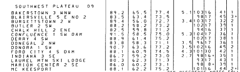

-
I was just noticed that when I was looking at some climate stats for the Ohio Valley region the other day. November is by far the month that's changed the least over the past 3 or 4 decades, which is odd. It might just be a mean reversion type thing, however. If you look at older historical data, November had previously been one of the fastest warming months of the 20th century.
-
Pittsburgh, Pa Summer 2024 Thread.
TheClimateChanger replied to meatwad's topic in Upstate New York/Pennsylvania
Heaviest rains were from northeast Beaver into southern Butler County, per radar estimates, with as much as 2.5-4 inches over the past two days. Lightest rainfall was in southern Beaver down into Washington County, with less than 0.5 inches. That screw zone just missed the airport area. -
Pittsburgh, Pa Summer 2024 Thread.
TheClimateChanger replied to meatwad's topic in Upstate New York/Pennsylvania
Ended up with a bit over an inch of much needed rainfall IMBY yesterday. Monthly tally around 2.5". Also, decent odds at another 90F day today at PIT, but the recent rains may present a difficulty. Could struggle to exceed 89F with the wetter grounds - maybe our first day to wind up exactly at 90F in 2024? -
Pittsburgh, Pa Summer 2024 Thread.
TheClimateChanger replied to meatwad's topic in Upstate New York/Pennsylvania
Only about half that in my backyard, but over 3/4” since yesterday afternoon. It’s been a nice rain coming in several brief spurts so no significant flooding issues. -
Occasional Thoughts on Climate Change
TheClimateChanger replied to donsutherland1's topic in Climate Change
For lack of a better place to put this, holy cow. h/t @donsutherland1 -
Central Pa. Summer 2024
TheClimateChanger replied to mahantango#1's topic in Upstate New York/Pennsylvania
I already showed there was one more 90F+ at MDT at this point in the year than there was in 2020. And then people came in rebutting that objective fact by saying there were fewer this July than in July 2020 and that I wasn't considering the backloading of prior summers where there was lots of 90s in August and even September. None of which is relevant to the fact that there was more 90s this year so far, and only a select few years with more. -
Central Pa. Summer 2024
TheClimateChanger replied to mahantango#1's topic in Upstate New York/Pennsylvania
I'm looking at met summer to date. But comparing this to 2020 certainly doesn't mean it's not been the hottest summer to date. In fact, it has been at MDT. 2020 was the prior hottest summer to date. So it's really funny saying it's only "4 short years ago" - what difference does it make how long ago when it was literally the prior hottest summer? Lol.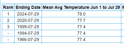
-
Central Pa. Summer 2024
TheClimateChanger replied to mahantango#1's topic in Upstate New York/Pennsylvania
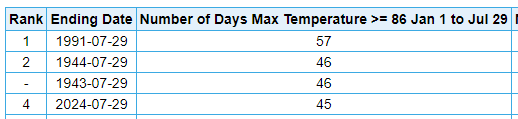
Actually no, because I can't predict the future. It would make little sense to compare this year's numbers to a full calendar year. One thing I find interesting is if you compare 1943 & 1944 to this year at the same location in which they were observed (CXY), this year actually jumps out to a slight lead.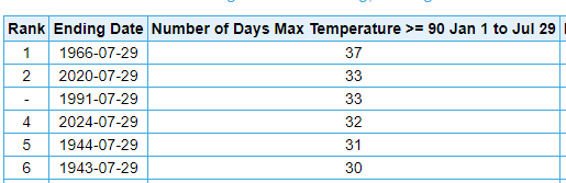
-
Central Pa. Summer 2024
TheClimateChanger replied to mahantango#1's topic in Upstate New York/Pennsylvania
This one is even more impressive. 50s scattered all over the place, even DC. At 18z in mid August. -
Central Pa. Summer 2024
TheClimateChanger replied to mahantango#1's topic in Upstate New York/Pennsylvania
Anyways, for the cold weather enthusiasts, you will love to see this. Very skeptical of low 50s at 18z in early August in northern Pennsylvania, but we shall see. -
Central Pa. Summer 2024
TheClimateChanger replied to mahantango#1's topic in Upstate New York/Pennsylvania
For most people in this subforum, it's probably the hottest summer to date for their lifetimes (certainly top 2/3) and one of only a select few years in terms of 90s. I'd say that's pretty impressive. -
Central Pa. Summer 2024
TheClimateChanger replied to mahantango#1's topic in Upstate New York/Pennsylvania
Very impressive figures. This summer seems to be performing very well in terms of heat here in the Commonwealth of Pennsylvania on a variety of metrics. -
Central Pa. Summer 2024
TheClimateChanger replied to mahantango#1's topic in Upstate New York/Pennsylvania
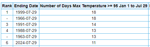
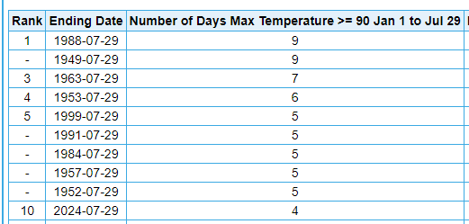
I haven't seen much discussion of this. But this summer has done incredibly well on 90+ days at Harrisburg. I know some have complained that recent warm summers haven't been super impressive on that end. Good chance to tack on number 26 today. At this point in the year, only 5 years have had more 90+ readings. This is the most since 1999. Same story with 95+ days: For the metric lovers, days at or above 30C/86F: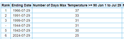
-
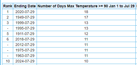
I would agree. There seems to be little objective evidence that this has "not been a hot summer" in the New York City metro area. It looks like it's top 3-5 to date at all of the local climate sites. I do note there's been a push on this forum to redefine what a hot summer is to strictly look at the number of 90+ days and/or to consider only one's subjective feelings rather than objective facts. But even with the 90+ metric, 2024 is doing pretty well in most places. At Central Park, only 18 years (dating to 1869) have had more days at or above 90F. And this is despite the encroaching jungle / shading of the ASOS. At Newark, only 10 years have had more days at or above 90F [3 of those 10 with just 1 more]. It's actually not normal for there to be constant 90s in the New York City area. If you think it is, you are misremembering. Now, it is true that JFK has only had 2 such days, which is actually one of the lower tallies there. But that's not representative of much of the region.
-
July 2024 Observations and Discussion
TheClimateChanger replied to HoarfrostHubb's topic in New England
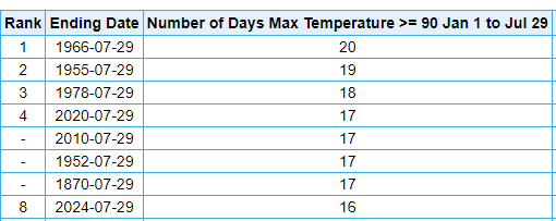
Also, people, it's actually not normal to have constant 90s in the summer - even in hot summers, in much of the northeast. Looking at ORH airport data only, I can find only 9 years with more 90s at this point in the year (out of 77 years). So only about 1 in 9 summers historically would be expected to have more 90s at this point, and none since 1999. BTV, dating back to the 1800s, only 9 years have had more 90s at this point. By contrast, 22 years had 0 90s at this point & 40 years had only 1 or fewer. CON, 8th most dating back to 1869. Only 2 years since 1978 have had more. It's crazy to me how people have to redefine what a hot summer is to pretend it's not a hot summer.
-
July 2024 Observations and Discussion
TheClimateChanger replied to HoarfrostHubb's topic in New England
2F above normal with the artificially inflated 1991-2010 norms is a HOT month. They already raised the norms like 1-2F from what they were in the 1990s. So this same month would have been considered blazing hot in the 1990s. 3-4F is a big deal in July. Let's play a game. Is it the hottest summer to date in SNE? At ORH, yes. At BOS, no. Tied for sixth place. CON, that would be a no. 4th place officially, but these are some suspiciously high readings from the early 1870s. BDL, yes. Just outside the greater SNE region. ALB, yes. Probably more NNE, but BTV. No, in 2nd place, 0.1F behind the blazing hot summer of 2020. Mount Washington, New Hampshire (MWN). No, 3rd place.
-
Central Pa. Summer 2024
TheClimateChanger replied to mahantango#1's topic in Upstate New York/Pennsylvania
That was also the 5th 90+ day of the season at Bradford. Since records began in 1957, only one calendar year had more 90+ days. In 1988, a total of 8 days reached at least 90F at the Bradford Regional Airport. -
Central Pa. Summer 2024
TheClimateChanger replied to mahantango#1's topic in Upstate New York/Pennsylvania
Record high of 90F at Bradford today, easily breaking the record of 87F set in 1988. A couple other locations approached record highs as well. DuBois reached 89F, 3F shy of the record set in 1988. Altoona topped out at 92F, 2F below the record set in 2002.


