Iceresistance
-
Posts
4,190 -
Joined
-
Last visited
Content Type
Profiles
Blogs
Forums
American Weather
Media Demo
Store
Gallery
Everything posted by Iceresistance
-

Texas/Oklahoma Discussion & Obs Thread 2021
Iceresistance replied to It's Always Sunny's topic in Central/Western States
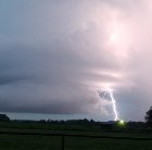
..A SEVERE THUNDERSTORM WARNING REMAINS IN EFFECT UNTIL 445 PM CDT FOR NORTH CENTRAL LOVE AND SOUTH CENTRAL CARTER COUNTIES... At 417 PM CDT, a severe thunderstorm was located 8 miles west of Overbrook, moving east at 10 mph. HAZARD...60 mph wind gusts and penny size hail. SOURCE...Radar indicated. IMPACT...Expect damage to roofs, siding, and trees. Locations impacted include... Ardmore, Lone Grove and western Lake Murray. PRECAUTIONARY/PREPAREDNESS ACTIONS... For your protection move to an interior room on the lowest floor of a building. -
Texas/Oklahoma Discussion & Obs Thread 2021
Iceresistance replied to It's Always Sunny's topic in Central/Western States
Widespread Storm activity across Texas & Southern Oklahoma, there is a Storm near Fairview, OK as well -
Texas/Oklahoma Discussion & Obs Thread 2021
Iceresistance replied to It's Always Sunny's topic in Central/Western States
Lots of Showers & Storms across Central, West-Central, Northern, Southern, & SE Texas right now . . . -
Texas/Oklahoma Discussion & Obs Thread 2021
Iceresistance replied to It's Always Sunny's topic in Central/Western States
2 Isolated showers have popped up on radar, one near Custer City & the other near Taloga -
Texas/Oklahoma Discussion & Obs Thread 2021
Iceresistance replied to It's Always Sunny's topic in Central/Western States
Big Storm crossing into Oklahoma near Hollis, could become Marginally Severe Showers/Storms are developing now from Ardmore to Walters, OK & also near Hobart, OK More Storms developing across most of Texas as well . . . -
Texas/Oklahoma Discussion & Obs Thread 2021
Iceresistance replied to It's Always Sunny's topic in Central/Western States
Developing showers are showing up between Ardmore, OK & Waurika, OK -
Texas/Oklahoma Discussion & Obs Thread 2021
Iceresistance replied to It's Always Sunny's topic in Central/Western States
I believe the first Storm in NW/Panhandle Texas has popped up west of Vernon, TX or SE of Memphis, TX There is another storm SE of Seymour, TX as well -
Sam is developing a CMG CDO Ring combined with a OW Eye . . .
-
NHC now has Sam at 120 mph & 960 MB Major #4
-
NHC now has Sam as a 100 mph CAT 2 Hurricane, but it's likely stronger than that . . .
-
It may baffle me somewhat too, but the NHC does what they do best, there was a system near France in 2016 was NOT named by the NHC since it was proven to be Non-Tropical because it was still connected to an occluded front, Teresa does NOT have any fronts & ASCAT (Mentioned in Discussion #1) proved it . . .
-
The GFS model also showed a Trough with the Cut-off Low & the Action also develops the 2nd Low Pressure area you're talking about . . . But it drifts since it's also cut off from the Jet Stream until it catches it later on . . .
-
Sam is now 85 mph per NHC
-
6z GFS turns this into a 936 MB Bomb Cyclone in the Long range . . .
-
Sam is a Hurricane per NHC. And also, it appears that the Monstrous Northern Band is limiting Sam somewhat, it's only a matter a time before it dies out & Sam will undergo RI & there is basically nothing to stop it . . .
-
...ANOTHER TROPICAL DEPRESSION FORMS IN THE EASTERN ATLANTIC.. ...EXPECTED TO STRENGTHEN OVER THE NEXT SEVERAL DAYS... 5:00 PM AST Wed Sep 22 Location: 10.1°N 33.9°W Moving: W at 15 mph Min pressure: 1008 mb Max sustained: 35 mph
-
OH COME ON! I'm just losing it at this rate! ...ROSE GOING THROUGH A ROUGH PATCH... ...BARELY A TROPICAL STORM.... The storm's environment is no bed of roses during the next several days, with persistent moderate westerly or northwesterly shear, plentiful dry air aloft and only marginally warm waters. Almost all of the guidance shows Rose decaying into a tropical depression this evening, and the new forecast is decreased from the previous one, especially in the near term. A continuation of this hostile environment should cause further weakening, and Rose is expected to be pushing up daisies in 3 days or less, degenerating into a weak remnant low and dissipating by the end of the forecast.
-
Southern Plains Winter 2021-2022
Iceresistance replied to Iceresistance's topic in Central/Western States
From BenNollWeather: December 2021: this forecast of stratospheric temperature anomalies is pretty unusual How unusual? The zonal mean anomaly between 60-90˚N is the *2nd warmest* predicted by @ECMWF (from September) compared to all years from 1993-2020. Thread: winter forecast tea leaves-- Ben Noll (@BenNollWeather) September 18, 2021 -
Rose may never be strong, but the NHC never stops coming up with funny discussions . . . The long-term future of Rose doesn't look golden either due to further increasing shear from an incoming upper- level trough. The new forecast is just a shade lower than the previous one, near the model consensus, with Rose likely sinking to a depression in a few days and degenerating to a remnant low by day 5.
-
Currently a Weaker system, but the NHC is having fun with this right now . . . Tropical Storm Rose Advisory Number 6 NWS National Hurricane Center Miami FL AL172021 1100 AM AST Mon Sep 20 2021 ...ROSE MIGHT NOT BLOOM INTO A MUCH STRONGER STORM ... SUMMARY OF 1100 AM AST...1500 UTC...INFORMATION ----------------------------------------------- LOCATION...17.3N 33.4W ABOUT 620 MI...1000 KM WNW OF THE SOUTHERNMOST CABO VERDE ISLANDS MAXIMUM SUSTAINED WINDS...40 MPH...65 KM/H PRESENT MOVEMENT...NW OR 320 DEGREES AT 16 MPH...26 KM/H MINIMUM CENTRAL PRESSURE...1007 MB...29.74 INCHES There are a lot of thorns in the way of Rose blossoming into a stronger storm. Increasing shear and drier mid-level air are on the way for tonight, competing against the somewhat warm SSTs. Thus Rose has about a day to flower into a moderate tropical storm, and no significant change was made to the short term forecast. At longer range, stronger shear and dry air should pull the petals off Rose one-by-one, causing the cyclone to slowly weaken. The new forecast is similar to the previous one, with some small 5-kt downward adjustments. Rose could even shrivel up into a remnant low by day 5, but that's not shown yet in the forecast.
-
Southern Plains Winter 2021-2022
Iceresistance replied to Iceresistance's topic in Central/Western States
I really hope that THIS Euro model forecast is wrong! O_O https://twitter.com/BenNollWeather/status/1439200092498522112? -
Southern Plains Winter 2021-2022
Iceresistance replied to Iceresistance's topic in Central/Western States
I had 3 Snowstorms in December 2020, & the 2 BIG storms in February 2021 -
Southern Plains Winter 2021-2022
Iceresistance replied to Iceresistance's topic in Central/Western States
1983 had a very inactive Atlantic hurricane season (Except Alicia in the GoM) & had an exceptionally powerful Arctic Blast that was reinforced by Several Cold Fronts in December . . . January 2017 was insanely cold, it got down to 1°F at Town, & -3°F in OKC . . . -
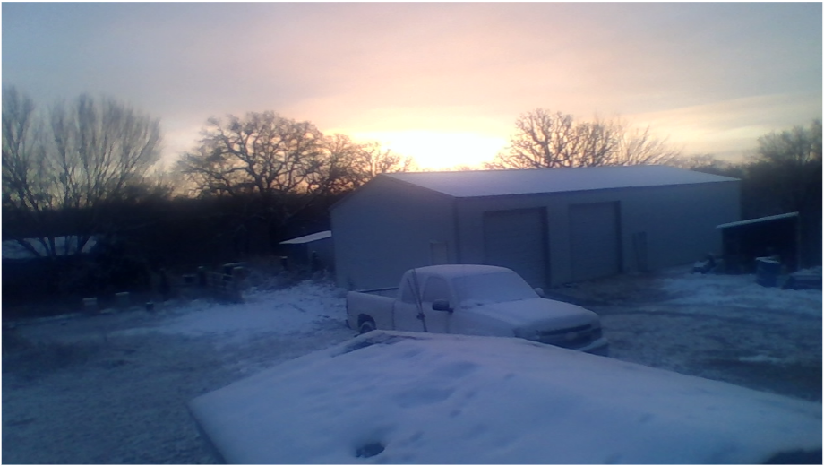
I'm starting this early, even though that the frost & freeze has not came in yet, it's time to prepare Last winter was HARD! The Historic 2020 October Ice Storm, the Triple Snowstorms in December (Including the Surprise Snowstorm on December 30th), the New Years Day Winter Storm, the Extreme cold & Snow in February with 18 inches of snow, -22°F Temperatures at the lowest, & even tried to snow in April . . . What will this Winter hold? It appears that unfortunately that this winter is likely going to be as bad or worse than last winter . . . This Summer was cooler than normal, & I have yet to reach 100°F at my house, which has never happened before in my lifetime, OKC has not yet reached 100°F either, it would be the first year since 2003 that it happened . . .
-
2021 Atlantic Hurricane season
Iceresistance replied to StormchaserChuck!'s topic in Tropical Headquarters
It was the opposite! That's when the Triplets of Terror showed up . . .


