

TimB
-
Posts
17,229 -
Joined
Content Type
Profiles
Blogs
Forums
American Weather
Media Demo
Store
Gallery
Everything posted by TimB
-

Western PA/Pittsburgh Summer Discussion 2021
TimB replied to Ahoff's topic in Upstate New York/Pennsylvania
I think the one thing I’ll give this summer, especially June and July, is that there were some incredible cool and dry days with lower humidity. June balanced it out with a fair number of very warm days. Problem with August has been that all the good days were front-loaded at the beginning of the month so it’s been a brutal almost 4 week period. -
Western PA/Pittsburgh Summer Discussion 2021
TimB replied to Ahoff's topic in Upstate New York/Pennsylvania
Can’t believe I’m calling a met summer a win when it will finish with a temperature departure near +1.2, even with respect to the warmer normals. But I think it was by and large a pleasant summer except for these warm, humid August stretches, we really didn’t get to 90 all that often, and our longest stretch of 80+ was 12 days (maybe 13 if tomorrow overperforms). -
10.6 at MDT? Good lord.
-
Western PA/Pittsburgh Summer Discussion 2021
TimB replied to Ahoff's topic in Upstate New York/Pennsylvania
Maybe there’ll soon be more confidence that Ida will be a fringe job so the only weather we have to think about is the upcoming perfect early fall weather. -
Looks like no power in the entire city now. Hope the levees hold.
-
Western PA/Pittsburgh Summer Discussion 2021
TimB replied to Ahoff's topic in Upstate New York/Pennsylvania
This is trouble. One mitigating factor here may be that the last couple rounds of heavy rain have been in north sections of the area (places near Cranberry and adjacent areas got near 3” from the midweek storms and got a wicked storm today). At least this may focus on the southern half of the area, though it is still early and lots of time to change. Still, as others have said, 4+” in a short time is probably too much for most of the area to handle no matter what the antecedent conditions are. (But it’s looking very likely that regardless of what happens, the good stuff we’ve been waiting for is just on the other side of Ida.) -
Western PA/Pittsburgh Summer Discussion 2021
TimB replied to Ahoff's topic in Upstate New York/Pennsylvania
The official NHC number is 150, though their latest update basically says this very well could become a Cat 5 before landfall. -
Western PA/Pittsburgh Summer Discussion 2021
TimB replied to Ahoff's topic in Upstate New York/Pennsylvania
Hard to tell if PBZ isn’t too keen on that scenario coming to fruition (I for one hope it doesn’t), if their forecast discussion is just bare bones as we know it so often is, or if they’re hedging their bets because we’re still 60-72 hours out from the onset of rain in our area from this storm. I’m leaning towards hedging their bets, as they do seem to have more to say about tomorrow’s event than they do about the remnants of Ida. But they’re not carrying anything more than 70% chances of rain when Ida moves through. CTP, as usual, has more to say on the matter. Beyond all that, I’m really worried that this will be a catastrophic event in Louisiana. It’s now up to a high end Cat 4. -
Western PA/Pittsburgh Summer Discussion 2021
TimB replied to Ahoff's topic in Upstate New York/Pennsylvania
Seems like a mixed bag of model solutions but a lot of them give us some taste of fall behind the remnants. -
Well, Steelers fans, I think Haskins played his way off the roster tonight. It was a fun ride.
-
540 line approaching far upstate NY at hour 288 on the 12z GFS. Edit: it also delivers these goods later on, though these are the remnants of a second major hurricane that landfalls in Louisiana:
-
Any rain in Pillow?
-
Western PA/Pittsburgh Summer Discussion 2021
TimB replied to Ahoff's topic in Upstate New York/Pennsylvania
This is nasty. I can see where there’d be flooding issues in areas where it’s sat for a long time. Also, daily climate report does confirm 90 was reached. I believe that’s #5 for the summer. -
Western PA/Pittsburgh Summer Discussion 2021
TimB replied to Ahoff's topic in Upstate New York/Pennsylvania
Knocking on the door of 90. The 25th was our hottest day of August last year as well. -
Beat me to it. Love it!
-
Western PA/Pittsburgh Summer Discussion 2021
TimB replied to Ahoff's topic in Upstate New York/Pennsylvania
Think it was a 4 day stretch last year with a 38, a 39, and 2 40’s. I looked at it the other day. -
I feel like I did the research on 9/23/1989 at PIT and concluded that the T we recorded on that day was likely real. So the bar is higher for me.
-
An interesting point. In theory, a T would be enough for that to happen. Problem is, to get the +8 departure, the part of the month where a T is even conceivable would have to be hot.
-
I can tell you one thing. It won’t be below normal!
-
I think it’s good stuff, personally. But I feel like it might be much like debating whether September will be above, at, or below normal snowfall.
-
We probably shouldn’t be debating something that will almost certainly not happen anyway. Not sure about MDT, but there is exactly ONE September here that achieved a +8 departure (+12.4 to be exact), and it’s probably the most suspect weather record I’ve ever seen. I will never believe that September 1881 had the same average temperature as July 2020 here.
-
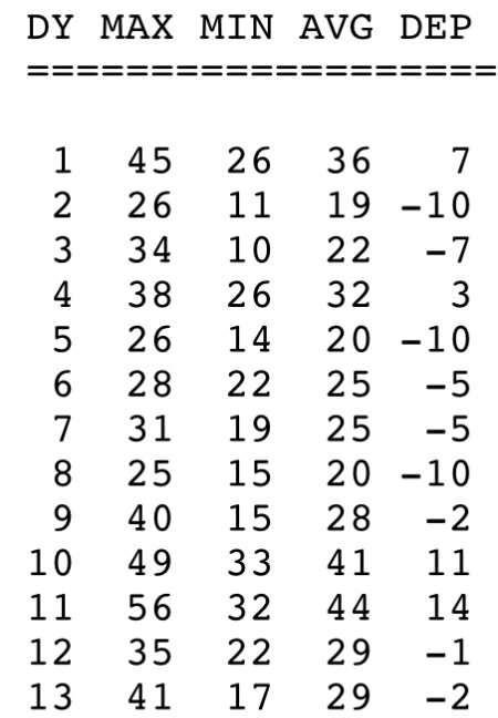
Your point is a good one, though I calculated the number needed from 9/8 to 9/30 in your scenario to be about +14: +8*30 = 240 -12*7 = -84 240 + 84 = 324 324 / 23 = ~14 Still extremely hard to do over a 23 day span.
-
Correct. 10 of the remaining days were +15 or more, and 3 were +25 or more. Pretty sure a +25 departure on just about any September day is basically impossible. That would be 107/88 on the 1st and 97/78 on the 30th at MDT.
-
What if I told you this was the first half of a February at PIT that ended up at +7.7?
-
So +8 on the late September low would be 61. Not exactly sweltering or far-fetched.

