

TimB
-
Posts
17,229 -
Joined
Content Type
Profiles
Blogs
Forums
American Weather
Media Demo
Store
Gallery
Everything posted by TimB
-
Also have to pretend I didn’t look at the CMC.
-
Yeah not an ideal look for sure but it’s improving.
-
White Christmas, anyone?
-
Sounds like the tropic of melanoma to me.
-
That said, I’m also about as fair as they come and I last a few minutes without sunscreen, especially at altitude or in the tropics.
-
The ozone stuff might have something to do with it, but it seems far-fetched that the strength of the sun itself has changed that much over the course of (half?) a human lifetime.
-
It is the EC so there’s a big caveat there.
-
EC gives us yet another possible solution for Christmas: a west-to-east low moving across the Mid-Atlantic. Too warm for snow, but closer to the solution we want?
-
Beginning to think it’s impossible to get a low that doesn’t cut this winter.
-
No white Christmas on the GFS but looks cold.
-

Western PA/Pittsburgh Winter 2021/22 Discussion
TimB replied to meatwad's topic in Upstate New York/Pennsylvania
Would think today’s record high of 64 is in play if we get some sun. Last year, PIT set a record snowfall of 9.3” on today’s date. What a difference a year makes. Edit: looks like 64 was reached just after noon. -
Unless and until the ensembles punt the way the operational models did overnight, we can’t punt yet. It’s 3rd and 14.
-
Anyone need the data for Kansas City while I’m in there?
-
DJF only.
-
The only thing I’ll add about “normals” is this, and I think I’ve said this before: seasonable temperatures are just fine if you don’t simply oscillate between normal and well above normal like what seems to happen a lot. The last time MDT recorded a negative double digit temp departure for a day was way back on 6/23. How many double digit positive departures have occurred between then and now? 22.
-
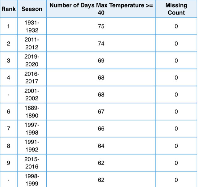
As @MAG5035and @Blizzard of 93alluded to, highs in the 40s are considered normal for parts of winter, but here’s the top 10: Note that 8 of these have occurred in the past 30 years.
-
I’m curious, what does it have in between?
-
I’ll try and look into this tomorrow.
-
December 15th-16th Warmth, Wind, and Severe Threat
TimB replied to Geoboy645's topic in Lakes/Ohio Valley
I’m aware of that, but my understanding is that 64 and 65 round to 64, while 66 and 67 round to 66. Edit: Regardless, 2:53 obs was 67. -
December 15th-16th Warmth, Wind, and Severe Threat
TimB replied to Geoboy645's topic in Lakes/Ohio Valley
Has since been broken, latest 5-min obs was 66. -
It’s not a bad look for cold, but doesn’t exactly deliver the goods.
-
Where do you personally draw the line?
-
I always enjoy these posts. The Zapata, TX reference reminds me of a PM I once got from someone inquiring about the September record high for the state of Texas because it was 107 in Zapata that day.
-
If it were up to me, I wouldn’t. Happy wife, happy life and all of that horseshit.
-
Was looking for addresses for Christmas cards that I had screenshot in my phone last year and came across a photo I took of the snow on 12/17/20, and got mildly depressed.


