Ed, snow and hurricane fan
-
Posts
2,133 -
Joined
-
Last visited
Content Type
Profiles
Blogs
Forums
American Weather
Media Demo
Store
Gallery
Everything posted by Ed, snow and hurricane fan
-

2024 Atlantic Hurricane Season
Ed, snow and hurricane fan replied to Stormchaserchuck1's topic in Tropical Headquarters
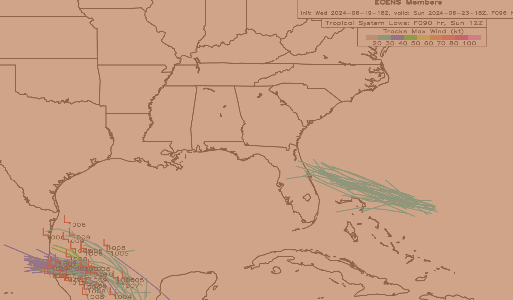
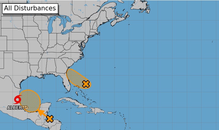
GFS ensembles between 7 and 10 days out, more members than not develop some kind of low in the EPAC, BoC or Caribbean. Bit odd, not sure which cycle the CPC GEFS forecast is, but MJO is neutral or slightly into 1/2 on the various members. A lot of the GEFS lows are weak, of course. Euro ensembles fewer lows, around 20. 5 of those from the Atlantic, which is interesting. -
Invest 92L in SW Atlantic reached SE US Fri
Ed, snow and hurricane fan replied to GaWx's topic in Tropical Headquarters
Maybe a post-season upgrade to keep the science right, but at this point, it will not be upgraded even if it wraps convection completely. Off to Twitter to see if Bastardi is having another angry reaction. It looks to me like a badly sheared TC. Bastardo has the same meaning in Italian and Spanish, Bastardi is the Italian plural. Le Batard is French. What the Romance languages have against illegitimate children, I'll never know. -
Invest 92L in SW Atlantic reached SE US Fri
Ed, snow and hurricane fan replied to GaWx's topic in Tropical Headquarters
Just like that the entire LLC is exposed again. -
2024 Atlantic Hurricane Season
Ed, snow and hurricane fan replied to Stormchaserchuck1's topic in Tropical Headquarters
40 to 50W? or 60-70W? 40 tp 50W is eye catching, there is a very narrow slot of lower shear in a trough. It would need more than a few days with improving conditions. I think it stays a frontal trough myself. Over 30C water would help, fronts either side of Florida could do that. Even a front more than a ways E of the Bahamas can do it. That one, not so much. -
Invest 92L in SW Atlantic reached SE US Fri
Ed, snow and hurricane fan replied to GaWx's topic in Tropical Headquarters
That is a somewhat sheared TD on the cusp of being a TS based on recon and current vis satellite. -
Invest 92L in SW Atlantic reached SE US Fri
Ed, snow and hurricane fan replied to GaWx's topic in Tropical Headquarters
I stopped subscribing a decade ago, but Joe Bastardi has what is usually a conspiracy theory, but might be holding true in this case. They did not do PTC2 yesterday/early this morning. Unless 92L really forces their hand by showing up as a tight spiral on radar, classifying it now means no going PTC last night/early morning was a mistake. Bastardi disagrees with NHC on all kinds of things, I've seen some unnamed storm off SEUSA which the NHC declared after recon showed no wind shifts/change in T/Td as being frontal, I think he was right, I looked at the HDOBS and plots. He may have had a point that Sandy should have been held as a hurricane to the New Jersey coast, it still had some tropical features. Somewhere in Suffolk actually verified 64 knots sustained just before the post-tropical declaration, Bastardi argued the downgrade was to avoid a hurricane verification in an unwarned area. I know its policy post Sandy to issue warnings for storms expected to go post-tropical, I think NHC might have dropped the ball. I checked JB yesterday, he was complaining about wind radii. Everything is a government plot. -
Invest 92L in SW Atlantic reached SE US Fri
Ed, snow and hurricane fan replied to GaWx's topic in Tropical Headquarters
I think it ties Alicia for highest pressure if it gets a name at 1014 mb. There may be a decimal I don't remember. -
2024 Atlantic Hurricane Season
Ed, snow and hurricane fan replied to Stormchaserchuck1's topic in Tropical Headquarters
because it looks like him, except the lips are more exaggerated. -
Invest 92L in SW Atlantic reached SE US Fri
Ed, snow and hurricane fan replied to GaWx's topic in Tropical Headquarters
I guess they didn't think a small area of 40 knots well NE of the weak and nebulous LLC warranted tropical storm watches/warnings, and thus no PTC. I'd think the PTC route now is the safest alternative, of course,, they have to balance that with not being the boy who cried wolf. -
2024 Atlantic Hurricane Season
Ed, snow and hurricane fan replied to Stormchaserchuck1's topic in Tropical Headquarters
Euro ensembles have a few lows of their own at the same time, and the ones that develop in the Caribbean come into the Gulf
-
Texas 2024 Discussion/Observations
Ed, snow and hurricane fan replied to Stx_Thunder's topic in Central/Western States
That system looks like it will be less of a rainmaker this far N, the slop gyre is weakening and shifting W as the ECUSA ridge builds back. Mid level humidity is lower and heights will be higher/ GFS and GEFS show only the lower RGV topping 2 inches and MBY getting about one half inch. DFW at near 1.8" PW still has subsidence and a large dry later from 700 to 400 mb per GFS.. -
2024 Atlantic Hurricane Season
Ed, snow and hurricane fan replied to Stormchaserchuck1's topic in Tropical Headquarters
Check out the GFS system in the BoC or Caribbean starting in about a week, A couple of the Caribbean ones find the weakness over the C. Gulf and come up into the N Gulf beyind. Looking at op fields on GFS, the slop gyre gets pushed W and disappears while the 7 day orange id forming, pushing that, if it does get tagged as an invest or PTC, due W. But it looks like a new gyre is forming as the new ensemble lows appera. -
Invest 92L in SW Atlantic reached SE US Fri
Ed, snow and hurricane fan replied to GaWx's topic in Tropical Headquarters
Speaking of recon, that looks like the EML. The dread cap that usually, except for this year, protects Houston from wide spread severe storms.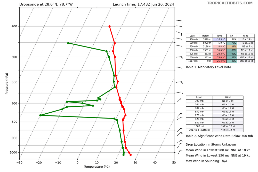
-
The rain helps Tamps., NL and Coahuila, but it looks like not much rain will get to the DF.
-
2024 Atlantic Hurricane Season
Ed, snow and hurricane fan replied to Stormchaserchuck1's topic in Tropical Headquarters
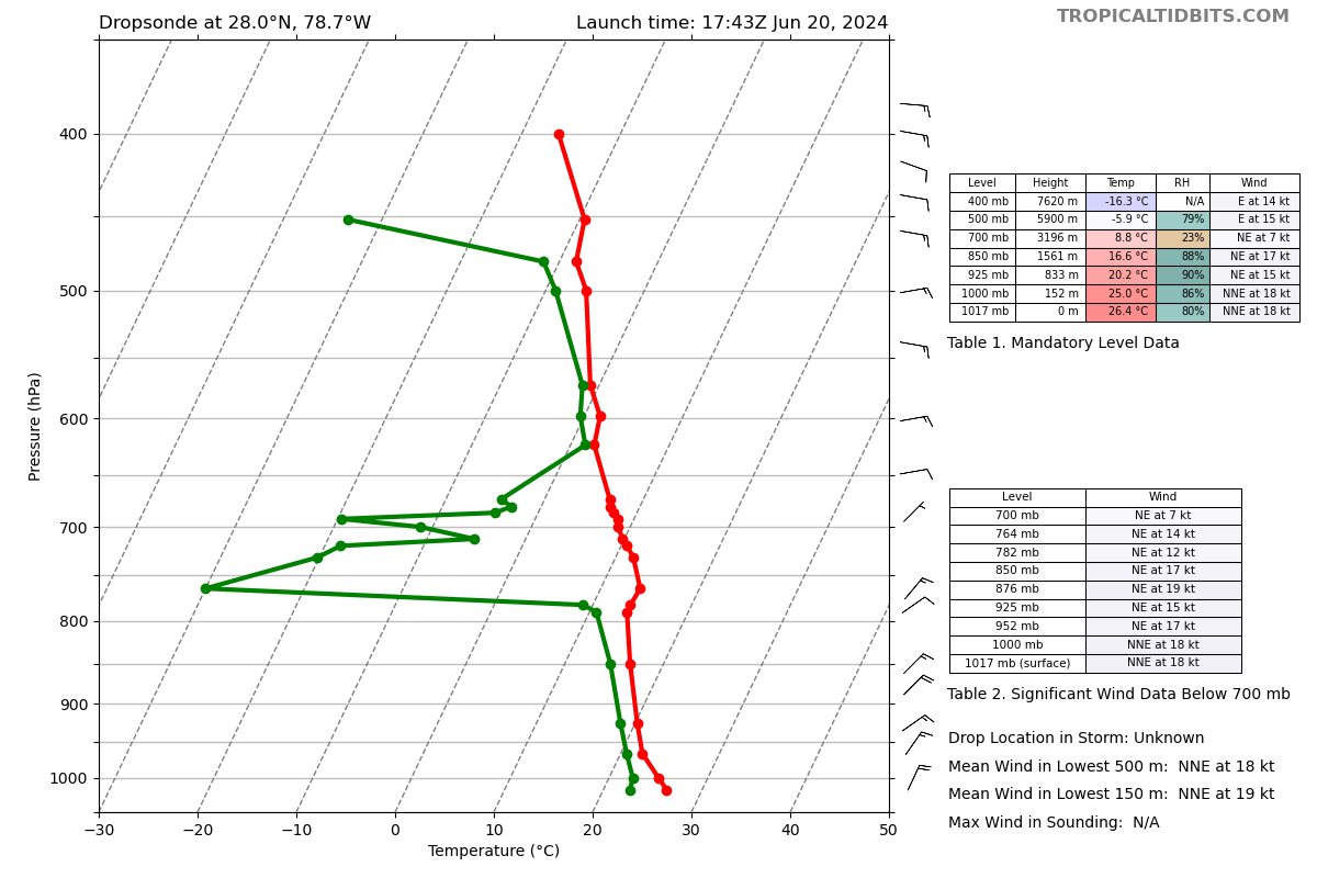
I don't think next BoC will be named. PTC2 or TD #03L unless the models are clueless, and I don't think they are. 92L is already a tropical cyclone, if maybe a bit hybrid and badly sheared. But the recon will find a closed LLC, even if half of it is exposed. Anyone have a recent ASCAT pass for 92L? -
2024 Atlantic Hurricane Season
Ed, snow and hurricane fan replied to Stormchaserchuck1's topic in Tropical Headquarters
-
50 knot LL winds. OT, why is 34 knots a gale and 50 knots a storm but 34 knots makes a tropical storm?
-
~-90C cloud tops- if this had organized a smidge early and had another half a day over water, this might have tried to be a hurricane. Winds near the center are just too weak for any chance of that happening in the next six or so hours. radar indicated tornado warned approaching San Perlita, the larger town Raymondville, just over 10k people, would be next. The times I wish I had RadarOmega or the GR radar apps.
-
2024 Atlantic Hurricane Season
Ed, snow and hurricane fan replied to Stormchaserchuck1's topic in Tropical Headquarters
If anything does develop from the 40% 7 day orange, 18Z Ensembles from WeatherNerds shows the new low landfalling in the exact same area Alberto will.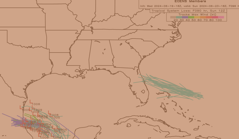
-
2024 Atlantic Hurricane Season
Ed, snow and hurricane fan replied to Stormchaserchuck1's topic in Tropical Headquarters
This is @GaWx, he was on this a week ago, I'll do the threat for 93L, Hijo de Alberto, which probably never gets named. Which may not even be an invest. Is that Steven Tyler through a filter? You spotted it first, you should start a new thread when you think it is appropriate. -
2024 Atlantic Hurricane Season
Ed, snow and hurricane fan replied to Stormchaserchuck1's topic in Tropical Headquarters
Does this deserve a 92L thread? It doesn't look great on satellite, but something is trying to happen. -
An amazing gradation of rainfall right through Houston with a band that isn't moving. A couple of brief heavier showers, but IMBY at the extreme edge of that band, mostly very light sprinkles. A patch of hazy blue sky shows some bigger cumulus E of here, a couple of more heavy showers possible, but I suspect DWH (Tomball) and IAH will be under half an inch. I think there will be big gradients even in S Texas, just checking the totals around CRP. EDIT TO ADD: Little vort maxes seem to be showing up on radar, one E of CRP.
.gif.85a28b85acafa60b390bbb597d78a219.gif)
-
Texas 2024 Discussion/Observations
Ed, snow and hurricane fan replied to Stx_Thunder's topic in Central/Western States
I'm at the extreme edge of the N-most feeder band. The rainfall gradient in the Houston area will be impressive. After the two heavy but brief showers around 2 pm just sprinkles. I was just out, I can see the edge of the heavy rain to the S, and it is close. Small patches of clearing with hazy blue sky show more cumulus buildups to the E, we may get a few more brief showers but I'd go a little under half an inch storm total on an over/under betting line. Hobby, I'd go the under, Galveston is already over an inch and a half, it should get to 2 inches. CRP is 2.3, BRO is similar, a hair less. -
Texas 2024 Discussion/Observations
Ed, snow and hurricane fan replied to Stx_Thunder's topic in Central/Western States
Maybe it is tightening up as it *very* slowly organizes. I've caught a few heavier showers last hour in the very N part of the N-most band. Maybe I'll do better than half an inch. Maybe I won't. 3km NAM shows very bandy rainfall, with >4 inch stripes N and S of Corpus Christi, but far less from CRP. Areas under an inch. I assume NAM would be close this close to landfall. Those bands shift a smidge and CRP could see 4 or 8 inches of rain. -
It is trying to get that shrimp shape that means intensification isn't far off, although the shrimp is at an angle.