Ed, snow and hurricane fan
-
Posts
2,133 -
Joined
-
Last visited
Content Type
Profiles
Blogs
Forums
American Weather
Media Demo
Store
Gallery
Everything posted by Ed, snow and hurricane fan
-

Texas 2024 Discussion/Observations
Ed, snow and hurricane fan replied to Stx_Thunder's topic in Central/Western States
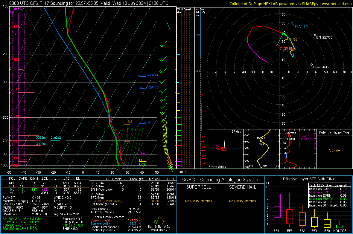
Radars from BRO and CRP look nice. IMBY. won't be much rain, probably under half an inch storm total, but today is a day the AC will run a lot less than usual. -
Texas 2024 Discussion/Observations
Ed, snow and hurricane fan replied to Stx_Thunder's topic in Central/Western States
Less than a quarter inch at Bush. Dripping water from a very bright sky. OTOH, waterspouts quite close to the beach in Galveston. https://x.com/JordanHallWX/status/1803465736712511510 Tornado warnings off and on, some very close to Corpus Christi. Watch possible. -
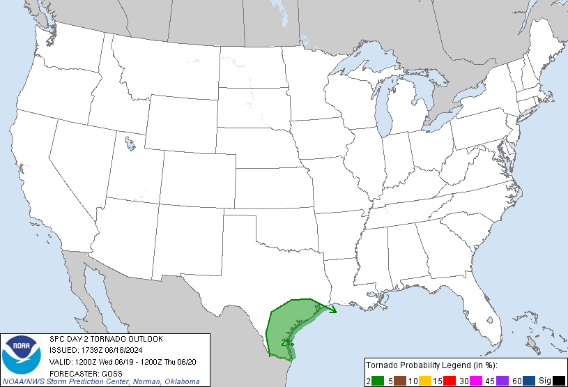
BULLETIN - EAS ACTIVATION REQUESTED Tornado Warning National Weather Service Corpus Christi TX 1143 AM CDT Wed Jun 19 2024 The National Weather Service in Corpus Christi has issued a * Tornado Warning for... East central Aransas County in south central Texas... Southern Calhoun County in south Texas... * Until 1215 PM CDT. * At 1143 AM CDT, a severe thunderstorm capable of producing a tornado was located 13 miles east of Lamar, or 16 miles east of Rockport, moving west at 30 mph. EDIT TO ADD: Off Jamaica Beach (the late Popo Party Pad) https://x.com/JordanHallWX/status/1803465736712511510
-
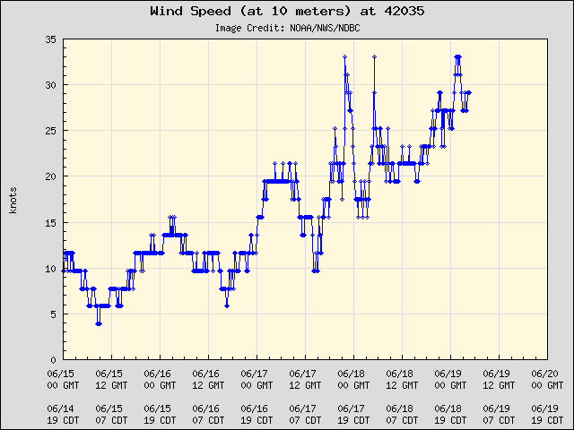
Someone used to call these slop gyres, when the CAG was a big loosely organized circulation. This may be further N than I have ever seen an area of interest or Invest from the 'Slop Gyre'. Daya buoy 22nm/41 km from Galveston might verify the TS warning.
-
2024 Atlantic Hurricane Season
Ed, snow and hurricane fan replied to Stormchaserchuck1's topic in Tropical Headquarters
92L? PTC2? Euro hour 90...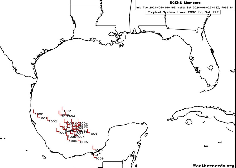
-
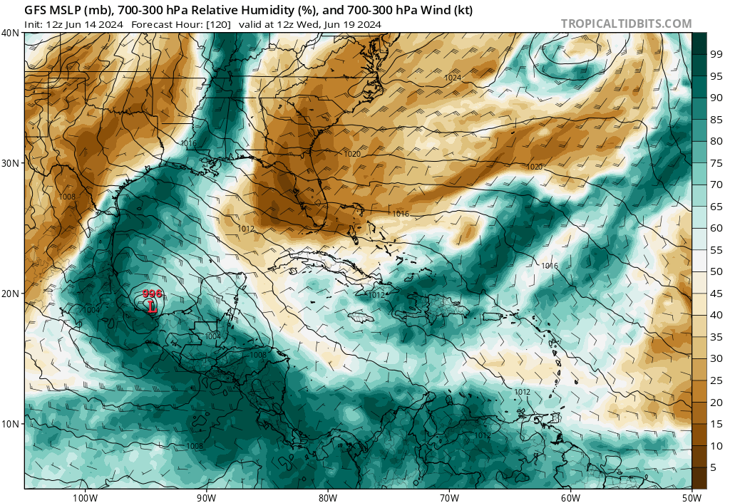
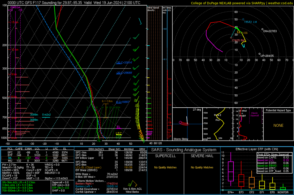
Wind gusts not quite to gale force just ahead of the showers. Breezy outside of but near showers. RAP 925 mb winds about 25 knots locally. Euro has 30 to 40 knot 925 mb winds later tonight. Much lower 20 to 25 knots between CRP and BRO. Not an organized system. Euro is 2.7" PW, below the all rime record, for 12Z CRP. 2.87 is CRP does a special 18Z sounding. 2.77 for tomorrow's 0Z sounding. 2.92 tomorrow (Wednesday evening) at 0Z around CRP, but just below 2.8 at the actual site. Future Alberto may be a slop system, but a KCRP all time PW record makes the storm memorable. SPC has immediate coast (slightly larger area tomorrow) in a >2% tornado marginal. Small areas of TS winds right near the coast before and after landfall on HAFS, picking a few random locations in Tamps,, SBCAPE near 500 J/Kg and good speed shear just inland. Tornado risk will exist anywhere near the landfall. EDIT TO ADD: New advisory on PTC1 extends the TS watch to San Luis Pass. Toll bridge off Galveston island (sometimes on busy weekends 288 is the way to come back), the water moving through that ~1/2 mile pass is moving fast, sometimes with white water. FM 3005 looks like it will flood past the seawall, ditto the same highway except Brazoria CR 257. The late Popo's party pad is near FM 3005, it doesn't take much to get water over the road. Thankfully, the Mexican Fan Palm is salt tolerant. When downtown/Broadawy flooded in 2008, most of the decades old majestic trees didn't survive. But the palms did. Anyway, only 2 to 4 feet of rise is expected, but HGX says that will close the roads on the barrier islands and the Bolivar Peninsula. Popo's daughter and her husband have the pad, they don't have as many parties as Popo did before his health started to decline.
-
Falcon Lake is at 10%. 100 mm/4 inches is a good thing except for the foothills of the Sierra Madre Oriental. Good to see you back. Unless this system organinzes and gets N of Corpus Christi, it won't have a concave coast aiding convergence, or the 40 knot forecasts are probably close. The lower pressure in the entire BoC is robbing gradient. I can see a 990mb 35 knot storm. KCRP is 1007 mb, that is pretty low to be that far from a tropical system. The low inland near Cd del Carmen is fading, I can see the rough outlines of where the low is forming now over water. I think it will be strong enough to avoid satellite cyclones as mentioned in the disco re: GFS.
-
2024 Atlantic Hurricane Season
Ed, snow and hurricane fan replied to Stormchaserchuck1's topic in Tropical Headquarters
What does WRA activation mean? Google isn't helping me. -
Texas 2024 Discussion/Observations
Ed, snow and hurricane fan replied to Stx_Thunder's topic in Central/Western States
I think I recently read Falcon is at an all time low level. Euro rain is less drought relief ( ~2 inches) for San Antonio and Austin than they'd want, although I suppose not flooding is a benefit. ICON and Euro both really enhance rain right at the coast, I'm guessing they handle coastal convergence better. NWS has harris County in a flood watch and shows 4-6 inches, which I suspect is about double what will actually fall near Houston -
PTC 1 later this afternoon, if I had to guess I'd think they might want (with cooperation of SMN) TS watches for near Tampico to near the US border. Or they may decide watches for what will be a 40 kt. TS can wait another 12 hours. Edit to Add: NHC in the outlook is hinting at a PTC
-
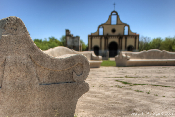
The best lower level rotation on radar is still over land. There does seem to be some rotation N of that over water, GFS suggests multiple centers. The overwater circulation has deeper convection and some lightning. The recon would have left half an hour ago per the POD, but I don't see any data. Suspect it has been cancelled. Tomorrow morning's recon might find something. The flooding may be between CRP and HOU if GFS is any guide. STX needs the rain, 2 and 3 out of 4 drought. They may not want 4 or 8 inches of rain in 2 days, but they need the rain. The reservoirs on the border are quite low. Amistad is 25%, Falcon is at an all time low 10%. Nuestra Señora del Refugio parish church in the not-so-drowned ghost town of Viejo Guerrero, Tamps., MX
-
2024 Atlantic Hurricane Season
Ed, snow and hurricane fan replied to Stormchaserchuck1's topic in Tropical Headquarters
Euro ensembles are rinse and repeat on the current Bay of Campeche cherry in 9 days. Once again TDs, maybe barely TS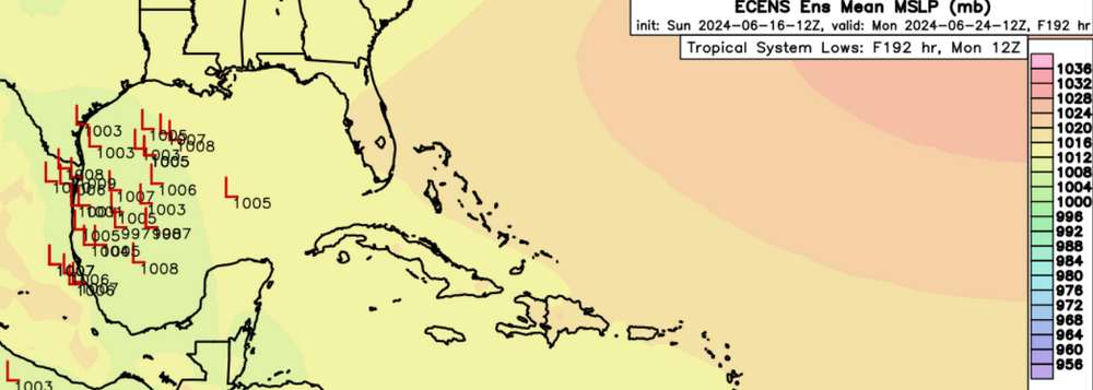
-
Just noticed a 90E on the Pacific side of the CAG. I can't see two systems developing that close to each other. 90E has broad turning already. Given the head start, I'd give it the nod. https://www.tropicaltidbits.com/sat/satlooper.php?region=90E&product=vis EDIT TO ADD: Looking at low level vort, 90E might be what actually develops in the BoC.
-
Texas 2024 Discussion/Observations
Ed, snow and hurricane fan replied to Stx_Thunder's topic in Central/Western States
@Stx_Thunder Heaviest rain away from the immediate coast is shifting S on the models towards CRP. San Antonio and Austin are in level 2/level 3 drought, the rain is a good thing for them.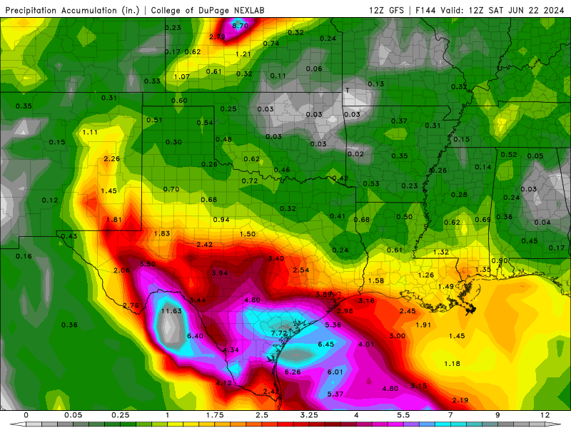
-
2024 Atlantic Hurricane Season
Ed, snow and hurricane fan replied to Stormchaserchuck1's topic in Tropical Headquarters
I need a PPV model. CoD and TT don't start showing Euro until 2 pm local. Judging by 6Z Euro and 12Z GFS, I think the >6 inch rainfall away from the immediate coast will be S of the Houston. Maybe as far S as Corpus Christi. An upslope on the Sierra Madre Oriental. -
2024 Atlantic Hurricane Season
Ed, snow and hurricane fan replied to Stormchaserchuck1's topic in Tropical Headquarters
Lemon may get a flight Tuesday, orange may get two flights tomorrow. 894 NOUS42 KNHC 161448 REPRPD WEATHER RECONNAISSANCE FLIGHTS CARCAH, NATIONAL HURRICANE CENTER, MIAMI, FL. 1050 AM EDT SUN 16 JUNE 2024 SUBJECT: TROPICAL CYCLONE PLAN OF THE DAY (TCPOD) VALID 17/1100Z TO 18/1100Z JUNE 2024 TCPOD NUMBER.....24-016 I. ATLANTIC REQUIREMENTS 1. SUSPECT AREA (BAY OF CAMPECHE) FLIGHT ONE - TEAL 71 FLIGHT TWO - TEAL 72 A. 17/1800Z A. 18/1130Z,1730Z B. AFXXX 01AAA INVEST B. AFXXX 0201A CYCLONE C. 17/1515Z C. 18/0915Z D. 19.5N 92.0W D. 22.5N 93.5W E. 17/1730Z TO 17/2230Z E. 18/1100Z TO 18/1730Z F. SFC TO 10,000 FT F. SFC TO 10,000 FT G. LOW-LEVEL INVEST G. FIX H. NO WRA ACTIVATION H. WRA ACTIVATION 2. OUTLOOK FOR SUCCEEDING DAY: A. CONTINUE 6-HRLY FIXES ON SUSPECT AREA IF SYSTEM DEVELOPS AND IS A THREAT. B. POSSIBLE LOW-LEVEL INVEST EAST OF THE BAHAMAS NEAR 25.5N 68.0W FOR 18/1800Z. -
2024 Atlantic Hurricane Season
Ed, snow and hurricane fan replied to Stormchaserchuck1's topic in Tropical Headquarters
Re: The firehose- I'm sure you've seen a second (weak) Gulf low forming a week out in the BoC or W. Gulf on some of the models/ensembles. No model shows anything much stronger than a 1000 mb, The GFS is persistent in showing convergence near I-10 and thus the >7 inch rains from near Houston to the Austin/San Antonio area near the N end of a pretty sharp surface trough, above/beyond the coastal convergence. Convergence and PW of 2.7 or greater, its quite the recipe. Canadian maybe also showing the enhanced precipitation, although less than the GFS runs, Euro doesn't have the localized enhanced rain at all N of the border.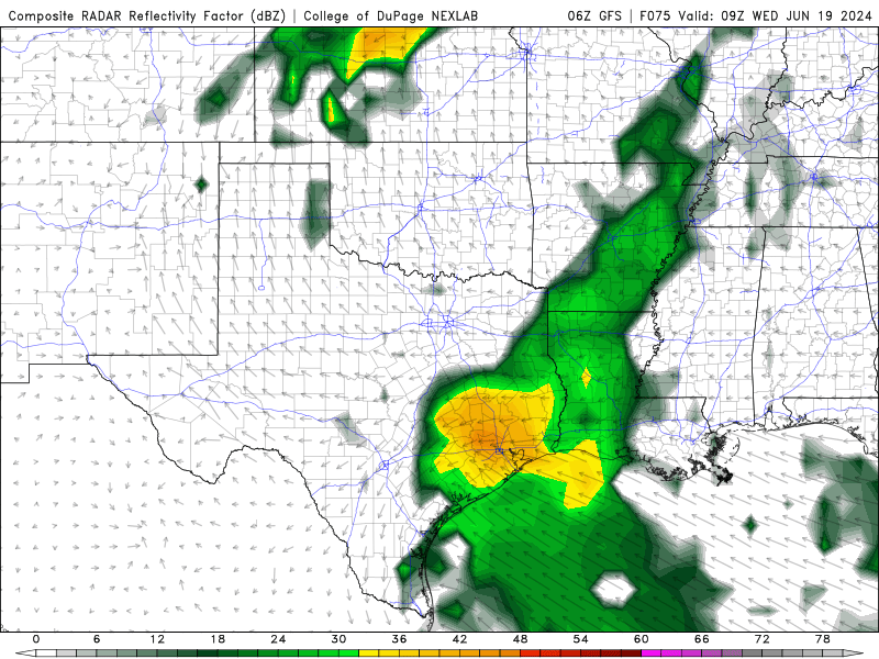
-
2024 Atlantic Hurricane Season
Ed, snow and hurricane fan replied to Stormchaserchuck1's topic in Tropical Headquarters
The fact the low in the BoC stays so weak/disorganized on the Euro and GFS maximizes convergence and PW IMBY. Similar >2.5" PW on the 2 models, but GFS 50 knot 850 flow compared to 30 knots on the Euro is the difference between over a foot in HOU area and about a third of that on the Euro. Maps posted on Texas thread in Western subforum. WPC 7 day is >5 inches for the coastal counties/parishes TX/LA, with heaviest rain in Louisiana. -
Texas 2024 Discussion/Observations
Ed, snow and hurricane fan replied to Stx_Thunder's topic in Central/Western States
GFS is 3 to 4 times more precip then the Euro, but both maximize rain over the Upper Texas Coast (but no part of the coast escapes several inches) as the BoC tropical low stays poorly organized allowing the best convergence and PW to be well N of the lowest pressure. GFS shown because a foot or more for Houston isn't happening, but eye catching colors. PW values are close for the Euro, but 30 knot 850 flow doesn't get the moisture in as fast.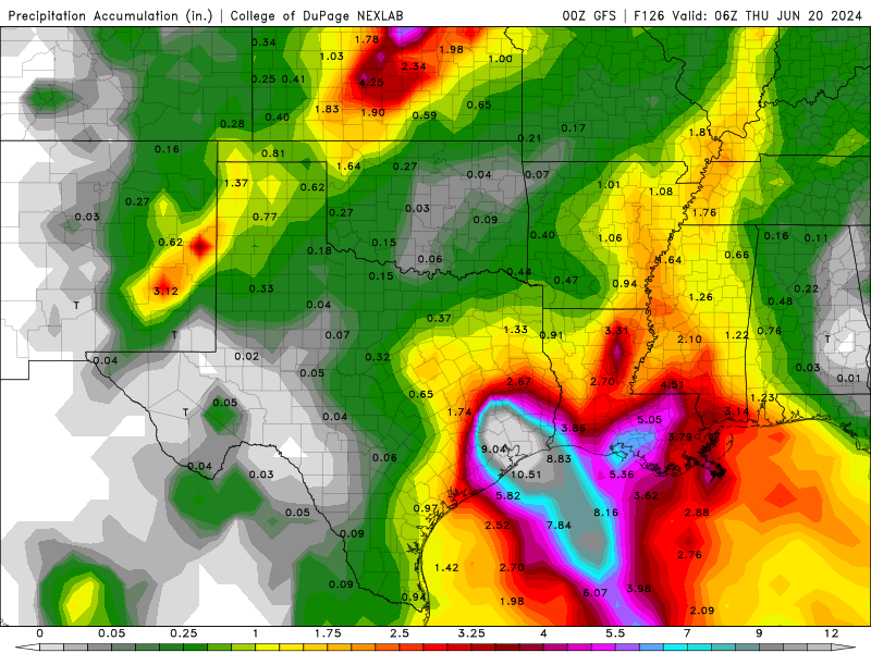
-
2024 Atlantic Hurricane Season
Ed, snow and hurricane fan replied to Stormchaserchuck1's topic in Tropical Headquarters
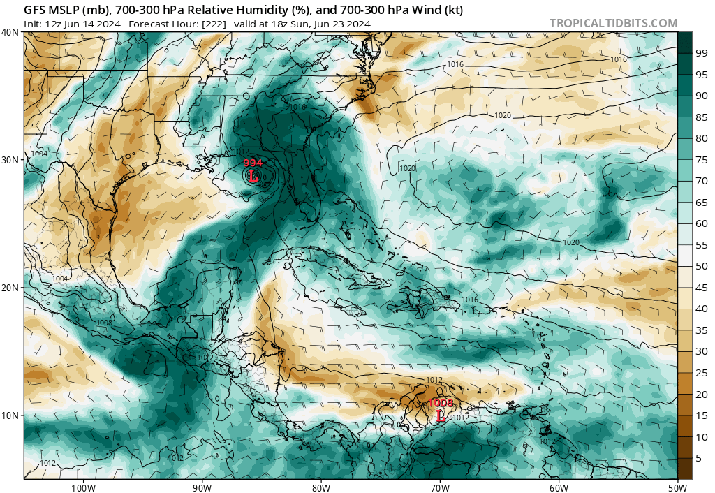
Just glancing at the 12Z models, I'm not sure which vorticity the models show rotating around the CAG will actually develop. Models showing too different lows from the CAG 4 or 5 days apart doesn't seem real to me. CMC showing a 992 landfall deep in the BoC followed by another low moving through the Yucatan Channel 60 hours later, that just isn't happening. GFS has about an extra day between that, not sure how an EPAC low landfalling in Honduras or El Salvador and then strengthening over land as it crosses Guatemala and Mexico as the GFS shows would happen. The second, more significant low, entering the Gulf closer to 90W, would be a Central or E Gulf threat in 8 or 10 days. Anything at 8 to 10 days is subject to change. Things at 5-7 days are subject to change, I'm not sure at all the BoC 50% orange low develops at all.

-
2024 Atlantic Hurricane Season
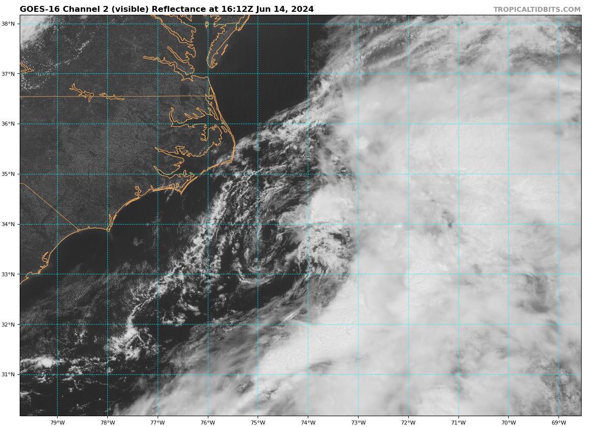
Ed, snow and hurricane fan replied to Stormchaserchuck1's topic in Tropical Headquarters
A see the completely exposed and somewhat elliptical low SE of Hatteras. I don't think recon will fly today.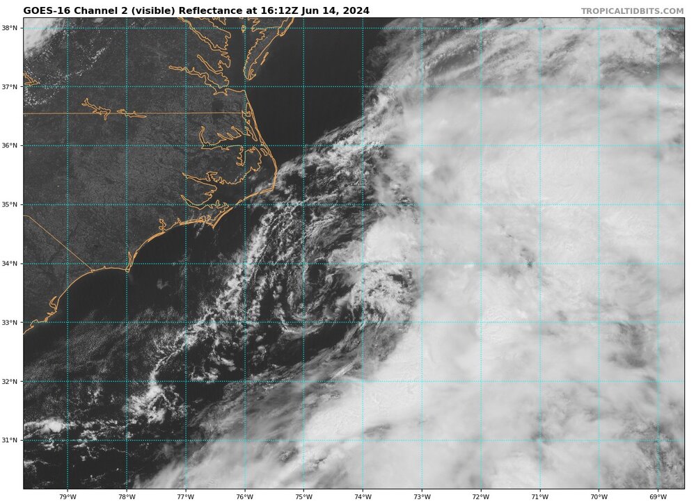
-
2024-2025 La Nina
Ed, snow and hurricane fan replied to George001's topic in Weather Forecasting and Discussion
I'd think someone would have posted it, but I didn't see it. NOAA has officially declared El Nino over, we are now neutral. -
2024 Atlantic Hurricane Season
Ed, snow and hurricane fan replied to Stormchaserchuck1's topic in Tropical Headquarters
Will there be enough there for NHC not to cancel the flight tomorrow, and will be the system be organized enough for a number or name? 447 NOUS42 KNHC 121550 REPRPD WEATHER RECONNAISSANCE FLIGHTS CARCAH, NATIONAL HURRICANE CENTER, MIAMI, FL. 1150 AM EDT WED 12 JUNE 2024 SUBJECT: TROPICAL CYCLONE PLAN OF THE DAY (TCPOD) VALID 13/1100Z TO 14/1100Z JUNE 2024 TCPOD NUMBER.....24-012 I. ATLANTIC REQUIREMENTS 1. SUSPECT AREA (WESTERN ATLANTIC - AL90) FLIGHT ONE - TEAL 71 A. 13/1800Z B. AFXXX 01AAA INVEST C. 13/1545Z D. 31.8N 76.2W E. 13/1730Z TO 13/2200Z F. SFC TO 10,000 FT G. LOW-LEVEL INVEST H. WRA ACTIVATION 2. OUTLOOK FOR SUCCEEDING DAY: POSSIBLE FIX MISSION NEAR 34.0N 73.0W FOR 14/1800Z. II. PACIFIC REQUIREMENTS 1. NEGATIVE RECONNAISSANCE REQUIREMENTS. 2. OUTLOOK FOR SUCCEEDING DAY.....NEGATIVE. -
2024 Atlantic Hurricane Season
Ed, snow and hurricane fan replied to Stormchaserchuck1's topic in Tropical Headquarters
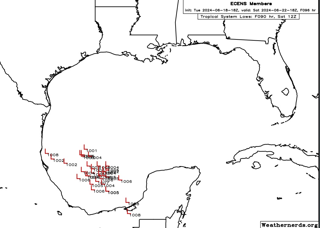
After the 30% BoC lemon does whatever it is going to do, maybe even getting a name before moving into Mexico well S of the border, the GFS and Canadian seem to think more vorticity will come up 3 or 4 days later from the Caribbean and form a Gulf low. GFS has the non-lemonized disturbance hitting New Orleans as a solid tropical storm beyond credible range/resolution truncation. Canadian at 240 hours has a broad disorganized low over the BoC but with a break between the ridges that would take anything organized towards the Central Gulf. Not putting too much stock in models 10 days and beyond, but I do think it is interesting if the weak system forecast to develop in the BoC is followed a few days later with another Gulf low of Caribbean origin. Even the 12Z Euro-AI suggests another Gulf low. -
2024 Atlantic Hurricane Season
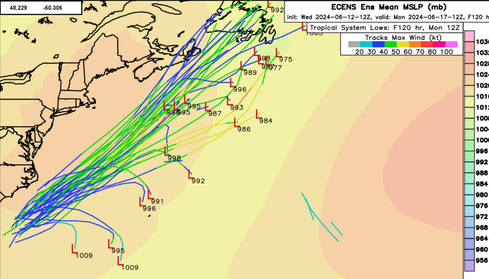
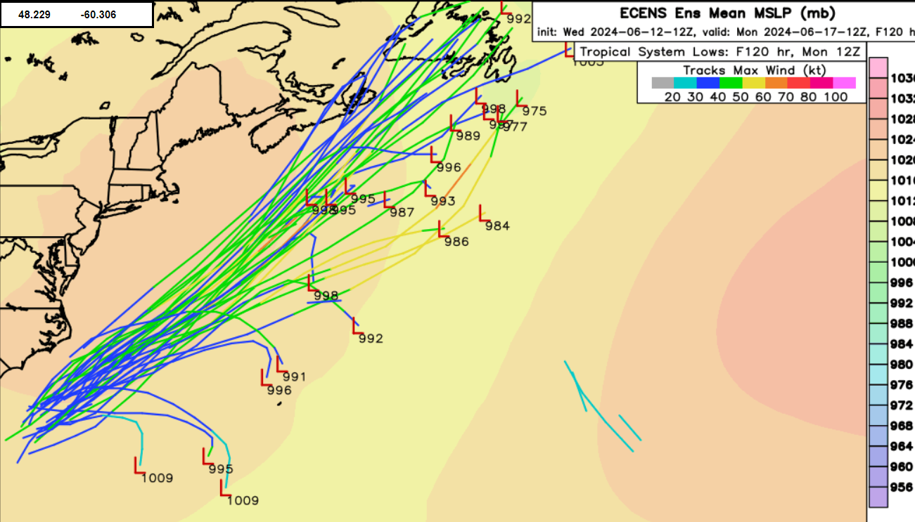
Ed, snow and hurricane fan replied to Stormchaserchuck1's topic in Tropical Headquarters
Newfoundland would have issues.