Ed, snow and hurricane fan
-
Posts
2,133 -
Joined
-
Last visited
Content Type
Profiles
Blogs
Forums
American Weather
Media Demo
Store
Gallery
Everything posted by Ed, snow and hurricane fan
-

Texas 2024 Discussion/Observations
Ed, snow and hurricane fan replied to Stx_Thunder's topic in Central/Western States
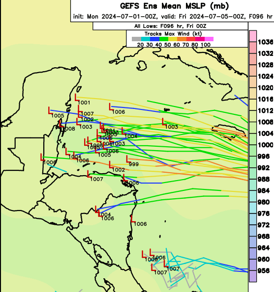
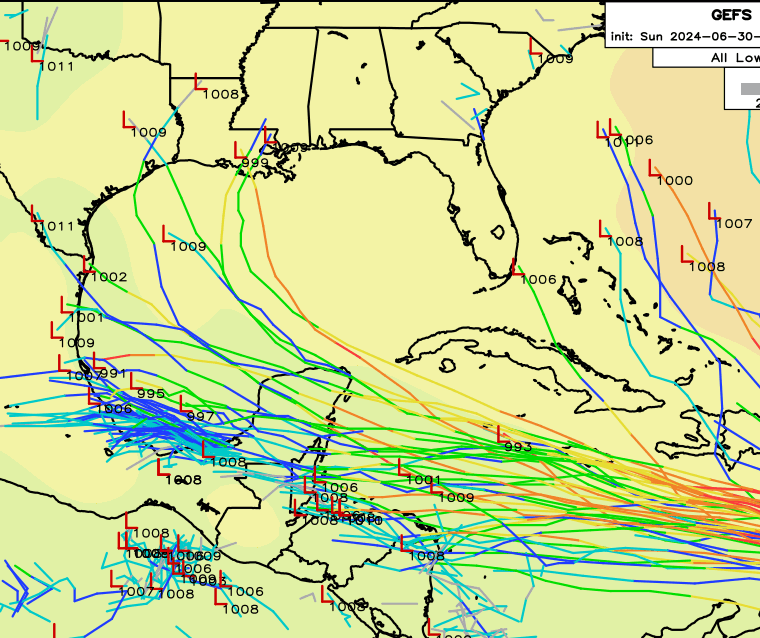
I count only 5 GEFS members with Texas landfall, and only 1 at hurricane strength. A couple more 18Z Euro ensembles hit Texas with hurricanes, but it is about 6 members, ~10%. It has time to change, but at ~6 days until a last landfall, the model spread should decrease. -
2024 Atlantic Hurricane Season
Ed, snow and hurricane fan replied to Stormchaserchuck1's topic in Tropical Headquarters
I suspect it may be related to Beryl ahead of it, but 96L now has low chances of development. Good news FWIW, just a glance at the MJO page, it shouldn't be in a favorable phase for TCs in the basin for a couple of weeks, and after Beryl, Euro 4 week TC probs show nothing in the Atlantic and WPAC finally picking up. No reason the next favorable period of the global waves (I have very limited understanding of them, that seems to be the domain of grad students, professors and post-docs) is there is no reason a month closer to peak season, when I gets hint the next active period starts won't be at least as active. Or that ASO in what seems a favorable pattern won't produce storms even when even when the MJO and friends aren't otherwise in positions that would support development. -
So much for that brief decreae in lightning frequency meaning weakening. It was just taking a short break.
-
Levi Cowan said he doesn't buy storms get so strong they alter the surrounding environment, based on scale, but he did not discount a storm as intense as Beryl might put enough outflow out to pinch off the base of the TUTT, which shears or ventilates Beryl depending on how far it moves W ahead of Beryl. Levi also said he is flying from Hawaii to the East Coast tomorrow, will be enough time zones from Hawaii to be jetlagged, and will post on a laptop. I suspect a vacation from JTWC he thought would be before peak Pacific season. That part is right, but nobody expects a Cat 4 (at the time) in early July in the Atlantic Basin. I'm assuming most weenies like me have discovered his YouTube channel, hopefully he is getting paid for generating so many YouTube hits. I'm still waiting for better agreement between global and high res hurricane models. NHC forecasters earning their pay with beryl, and probably several more times this year. Dr. Roundy told me the next favorable global wave pattern is probably late July/early August, and he doesn't see any reason it won't produce more storms.
-
Since I'm not a master of the various other sensors, and most are, by nature, hours out of date, I'm trying to work on change of lightning frequency. Accurate for SETX storms near severe limits, more lightning, more likely severe, sudden drop, weakening imminent. Lighting frequency is starting to decrease, Beryl is likely at the peak. GFS well supported by ensembles in pronounced weakening before Jamaica, or odds of a major impact or even significant wind impact seems low. Rain is still an issue. I'm getting to IMBY mode, get to HEB or Kroger before the rush. I still think signs are good so far for SETX. Major hit in the US or MX mainland seems unlikely. I still defer to NHC. OT, models, why doesn't NHC use FSU super ensemble, which seemed to be AI before AI was cool, comparing model performance for different situations and learning to weight various model and ensembles based on prior forecast verification.?. Is it just renamed, or did the FSU super-secret project only the NHC and select few could see, over?
-
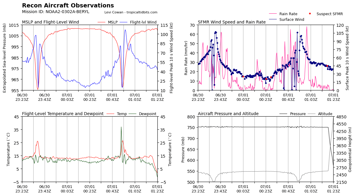
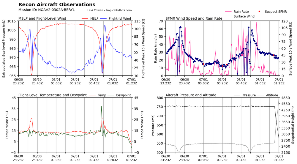
Refreshing the recon page on TT now. The plane is flying from the Virgin Islands, latest refresh it may have begun to descent to storm level.
-
I'm trying to see why someone seemed to be yahoo-ing as homes were getting damaged, but at least the homes seem well built, Not well built enough not to prevent major roof damage.
-
There are ensemble members that apparently shift or weaken the big high over Texas enough even Louisiana is in play. But as mentioned, the majority of the Euro members show weakening and a turn W with lower threats to Jamaica, the Yucatan, and mainland coast of Mexico.
-
Euro ensembles suggest the strength of Beryl determines risk to Jamaica and landfall location in the Yucatan and beyond. The majority show weakening and a turn W. The minority that stays strong is further N the entire way and a threat to the Tamps. and TX coasts. There are some scary looking members even to Louisiana, but the strong/N members are about 20% of the ensemble members. Or I'll be watching, I may beat people to top off on gas, get a few more flashlights, fill empty gallon plastic bottles from the sink, but if the majority of the ensembles are correct, that won't happen at least for Beryl. The early big storm being the biggests, that would be nice. I don't know much about planetary waves, but I don't see why as summer progresses, the waters warm more, and South America starts to cool as the sun angle heads back for the equator, weakening trades in the Caribbean, that they'll be more majors
-
I have to wait to near 11 am CDT to see GFS, and I have an appointment, off to the shower, but if the 12Z models confirm the 0Z models, I think while nobody can't rule out the odd ensemble member that comes at Texas or Louisiana as a strong hurricane, the odds are quite remote. Some people seem to see the GFS 30 minutes before I do and the Euro more than an hour earlier. I also think the NHC forecast of a hurricane into the Yucatan is being on the side of caution. Jamaica, I think might be a hurricane, might not. It is good watches are up already there. They might get lucky on the winds, but they might not. Never been there, a James Bond movie from before I was born suggests some terrain which would enhance rainfall.
-
I don't know how many are insured. Being on a hill as some are less than a mile from the ocean and a major hurricane tells me a lot of homes will lose roofs, Inike in Kawaii style.
-
Texas 2024 Discussion/Observations
Ed, snow and hurricane fan replied to Stx_Thunder's topic in Central/Western States
The Louisiana and Texas threat is dropping based on almost all global models and ensembles. Texas isn't completely safe, the timing of the trough and the strength of Beryl affects how much it turns, but the models are encouraging. Rain in July is always welcome, but some solutions are so far S there won't be much if any in Texas. -
Are you the guy that used to like to walk in heavy snow in the Mid Atlantic forum? Anyway, the trend is your friend and the Buda-Kyle-San Marcos metro is about 150 miles inland. All the major globals now take what is left of Beryl after the Yucatan into Mexico. Texas isn't 100% safe, Beryl tries to turn N on most of the models but starts too late. Ensembles do show a gap between the Atlantic ridge and the Sonoran ridge, but too late to turn a weakened Beryl. If the timing changes, that changes where Beryl feels the trough between the ridges. But the globals and ensembles are Texas' friend. Jamaica and Yucatan's friend as well, most show significant weakening before it gets there. I think once the Windwards are clear, after a significant hurricane, the threat lowers. I'd be nervous about the break in the ridge, but almost all the models have a weaker system for the Yucatan that won't feel the approaching trough because it is weak until it is very close to Mexico. So not 100% confident, but I think the odds of a US impact are dropping.
-
Night. GFS ensemble also with a shift S. Almost all show weakening before
-
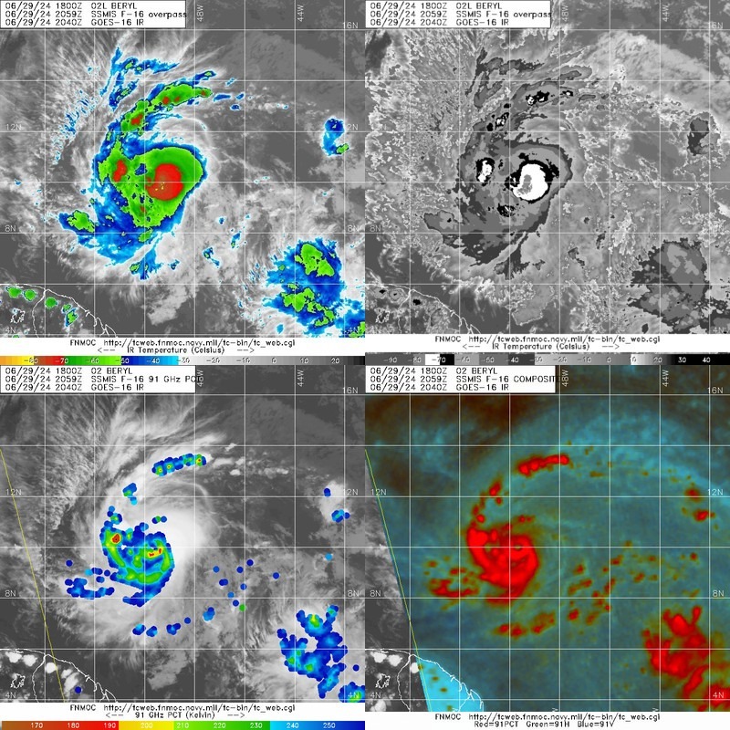
Inner eyewall looks to be fading fast. https://www.barbadosweather.org/Radars/LeafScripts/BMSRadarProducts.php
-
Globals seem to be trending S. I'm not planning to stay up for the Euro but I suspect it follows.
-
First hint of a wind max away from the eyewall/EWRC.
-
Texas 2024 Discussion/Observations
Ed, snow and hurricane fan replied to Stx_Thunder's topic in Central/Western States
757 SXUS74 KFWD 302139 RERDFW RECORD EVENT REPORT NATIONAL WEATHER SERVICE FORT WORTH TX 435 PM CDT SUN JUN 30 2024 ...RECORD HIGHEST MINIMUM TEMPERATURE SET AT DALLAS/FORT WORTH... THE LOW TEMPERATURE AT DFW AIRPORT THIS MORNING WAS 82 DEGREES. THIS BREAKS THE RECORD HIGHEST MINIMUM TEMPERATURE FOR JUNE 30 OF 80 DEGREES, SET PREVIOUSLY IN 2023, 2020, AND 1979. $$ -
If an EWRC started now, could Beryl weaken enough not to being major hurricane winds to at least some of the islands? Checking Wiki, they are privately owned islands. I hope those had sea planes. One thing in the islands favor, some are volcanic, which suggests little shallow water to build surge on. Besides the small RMW.
-
I'm not sure JM can even get to one of the Grenadines before the airports close.
-
GFS is an outlier to its own ensembles. I see 5-6 perturbations with a US direct impact. Most ensembles badly weaken Beryl even before it gets to the Yucatan.
-
If this storm does wind up like some of the globals suggest, a US threat in the long range, the thread might get busy enough for storm mode, and some of the random posts or arguments over CC might get deleted. EDIT TO ADD: CC is Climate Change. Something is causing ever busier hurricane seasons.
-
Texas 2024 Discussion/Observations
Ed, snow and hurricane fan replied to Stx_Thunder's topic in Central/Western States
IAH may finally hit 100F tomorrow. GFS and Canadian both show a hint of a backdoor front into E. Texas Monday, with increased PWs, but not much in the way of rain. -
I'm on the Boomer/Gen X cusp, and I don't understand it all. he asks good questions. CIMMS automatic Dvorak is impressed. Eye almost closed. Date : 29 JUN 2024 Time : 221021 UTC Lat : 10:09:08 N Lon : 49:37:37 W Final T# Adj T# Raw T# 4.4 4.4 4.3 Center Temp : -71.7C Cloud Region Temp : -70.1C Scene Type : UNIFORM CDO CLOUD REGION w/ MW EYE

-
2024 Atlantic Hurricane Season
Ed, snow and hurricane fan replied to Stormchaserchuck1's topic in Tropical Headquarters
Toss up. 94L looks better on satellite than it ever has.