Ed, snow and hurricane fan
-
Posts
2,133 -
Joined
-
Last visited
Content Type
Profiles
Blogs
Forums
American Weather
Media Demo
Store
Gallery
Everything posted by Ed, snow and hurricane fan
-

2024 Atlantic Hurricane Season
Ed, snow and hurricane fan replied to Stormchaserchuck1's topic in Tropical Headquarters
I think his name is Chris Hebert. He is usually pretty good. Only think about S2K is the good posts are buried in not so good posts. -
2024 Atlantic Hurricane Season
Ed, snow and hurricane fan replied to Stormchaserchuck1's topic in Tropical Headquarters
A few 6Z GFS ensembles now see the Euro system. About a third of the members.
-
2024 Atlantic Hurricane Season
Ed, snow and hurricane fan replied to Stormchaserchuck1's topic in Tropical Headquarters
If the Euro storm does develop, it will be developing before favorable upward motion gets to the Atlantic. That would indicated a busy season. I think @ldub23no more than 2 NS in August will bust badly.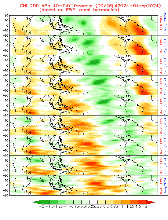
-
2024 Atlantic Hurricane Season
Ed, snow and hurricane fan replied to Stormchaserchuck1's topic in Tropical Headquarters
First ever hurricane hunter flight, 1943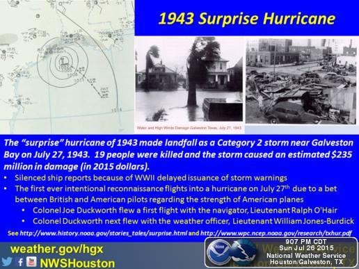
-
Texas 2024 Discussion/Observations
Ed, snow and hurricane fan replied to Stx_Thunder's topic in Central/Western States
Special weather statements (strong but sub-severe) and flood watches and advisories in the triangle LRD-BRO-CRP.
-
2024 Atlantic Hurricane Season
Ed, snow and hurricane fan replied to Stormchaserchuck1's topic in Tropical Headquarters
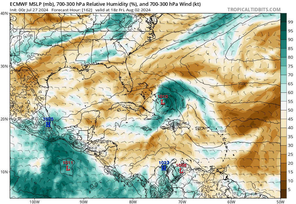
If I am not mistaken, the Euro ensembles run at the same resolution as the op, 9 km. The GFS ensembles run at half resolution. That the op 6Z GFS keeps showing a somewhat similar outcome to the Euro, with almost ensemble support, may be a resolution issue. At the time range, a Eastern Gulf versus a SEUSA landfall is still up in the air. The GFS develops the low later, which may be part of the difference between the GFS and the Euro EDIT TO ADD: I was starting to get worried that with only the Euro showing this for several days that this would be a spurious cyclone. But Canadian coming on board. Canadian is also a E Gulf hit. Earlier development going N makes sense. No clue whether Euro or GFS/Canadian will be correct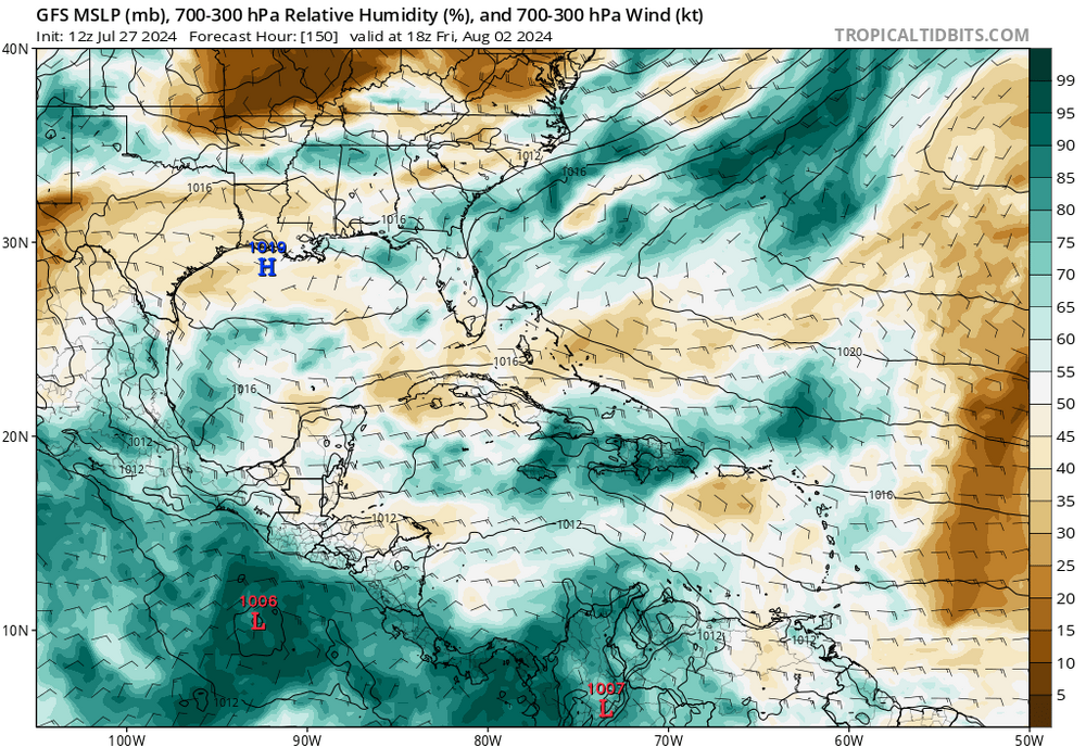

-
2024 Atlantic Hurricane Season
Ed, snow and hurricane fan replied to Stormchaserchuck1's topic in Tropical Headquarters
NHC has a 7 day lemon on the system the EPS have. Bud is dissipating in the EPAC. CFS bias adjusted MJO predicts MJO emerging into 8 and then 1 as August begins. The other MJO forecasts on the CPC page, not so much. Empirical MJO sees conditions becoming favorable in about 10 days. I tend to think the Euro ensembles are a smidge premature. Unless it gets significant support from the other reliable models and ensembles, I think the 20% lemon stays a lemon until dropped
-
2024 Atlantic Hurricane Season
Ed, snow and hurricane fan replied to Stormchaserchuck1's topic in Tropical Headquarters
Other than a few random perturbations on the other ensembles, this looks like Euro ensembles against the world. -
Texas 2024 Discussion/Observations
Ed, snow and hurricane fan replied to Stx_Thunder's topic in Central/Western States
Been raining off and on all week. -
Central & Eastern Pacific Thread
Ed, snow and hurricane fan replied to Windspeed's topic in Tropical Headquarters
Kush is long gone, @Tezeta knew him. -
Central & Eastern Pacific Thread
Ed, snow and hurricane fan replied to Windspeed's topic in Tropical Headquarters
There used to be a poster who named himself here for the marijuana of the Hindu Kush. He'd love a storm named 'Bud'. The E side of the LLC is exposed, It looks like shear, but CIMMS shows only 10 knots. GFS shows dry air to the N and E that looks like it will follow Bud for a while. -
Central & Eastern Pacific Thread
Ed, snow and hurricane fan replied to Windspeed's topic in Tropical Headquarters
Bud is a cool name on many levels. Weird having more NS in the Atlantic than the EPAC in the last third of July. -
2024 Atlantic Hurricane Season
Ed, snow and hurricane fan replied to Stormchaserchuck1's topic in Tropical Headquarters
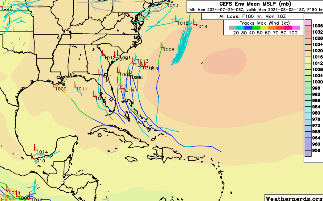
Many European ensembles show a spray of tropical lows heading for Florida or SEUSA in 10 days. GFS ensembles have nothing. Euro ensemble members have, IIRC, the same grid resolution as the op, the GFS ensembles don't.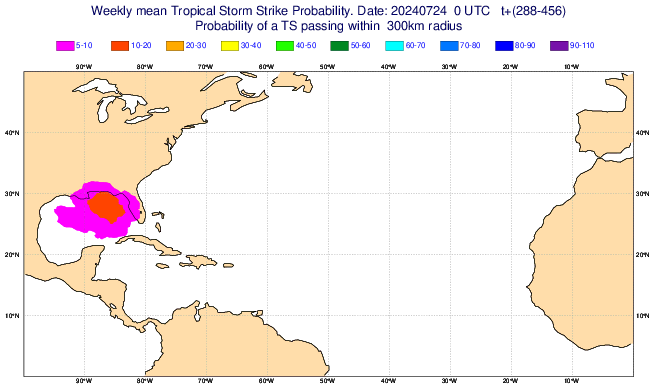
-
2024 Atlantic Hurricane Season
Ed, snow and hurricane fan replied to Stormchaserchuck1's topic in Tropical Headquarters
Two weeks out, but op Euro shows something trying to develop near/N of the Greater Antilles and has some ensemble support. The GFS ensembles are not showing this. But I'm expecting the first week of August to continue to be slow, so this is before I expect the switch to be thrown after about August 10. CFS weeklies start throwing the switch in early August, above normal MDR shear goes to normal or slightly below normal, and the basin quickly changes from subsident upward motion to favorable upward upper air motion.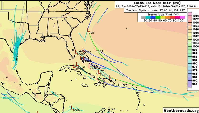
-
2024 Atlantic Hurricane Season
Ed, snow and hurricane fan replied to Stormchaserchuck1's topic in Tropical Headquarters
Euro weeklies finally picking up on an increase in tropical chances near mid-August. Euro ACE goes from well below normal ACE to normal in early August to 140% normal ACE in mid-August, when normal ACE is starting to increase. As posted by Dr. Hazelton, both GFS and Euro ensembles show shear in the MDR dropping to near or below normal in early August, https://x.com/AndyHazelton/status/1815553331131031956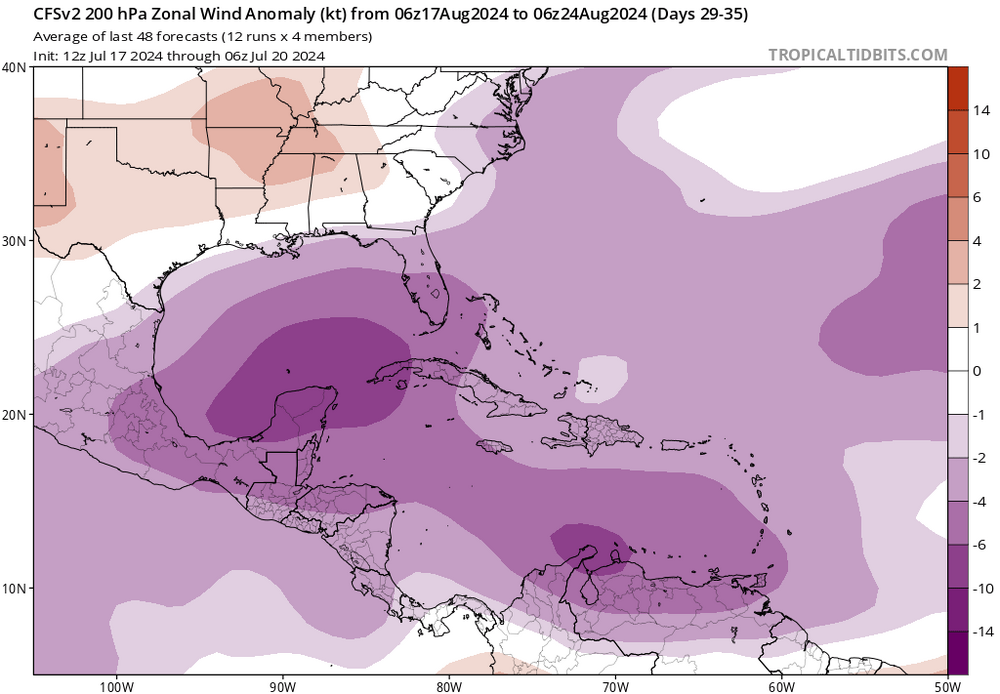
-
Central & Eastern Pacific Thread
Ed, snow and hurricane fan replied to Windspeed's topic in Tropical Headquarters
D'oh! -
2024-2025 La Nina
Ed, snow and hurricane fan replied to George001's topic in Weather Forecasting and Discussion
I know the rainfall implications, hence the Long Paddock SOI site. Are there temperature implications as well for Australia. Some interior Australian town withing 20 degrees of the Equator got to 33*F, an all time July record. Another cold snap following one earlier in July. With a neutral ENSO, is there anything else that might affect temps? https://www.abc.net.au/news/2024-06-23/australias-coldest-town-revealed-following-week-long-cold-snap/104006148 -
Central & Eastern Pacific Thread
Ed, snow and hurricane fan replied to Windspeed's topic in Tropical Headquarters
There is stuff in the Pacific. -90*C cloud tops for 05W. -
2024 Atlantic Hurricane Season
Ed, snow and hurricane fan replied to Stormchaserchuck1's topic in Tropical Headquarters
Glancing at the CFS weeklies, the shear goes from generally above normal across most of the MDR to neutral just after August 15. MDR storms. Heights rise (per Euro ensembles) over N. America the next 15 days, but even though the heights are above normal over the Central and Eastern Gulf, they are lower than surrounding areas, and the ensembles show a col (from the French word for mountain pass) between the ridge centers over the SW and the Atlantic ridge. Or weak fronts and vort maxes could wind up stalled over the E Gulf over 30 to 31*C water. That cold result in a quick spin up that could get a NS before mid-August, but so far, it looks slow to me until mid-August MDR wise. Mid-August, if CFS is correct, there is a fairly quick transition from unfavorable to favorable upper motion as well. W Atlantic shown, but the favorable motion spreads across the entire MDR. Euro long range products show ACE going from well below normal (in a low ACE part of the season) towards normal by mid-August
-
2024 Atlantic Hurricane Season
Ed, snow and hurricane fan replied to Stormchaserchuck1's topic in Tropical Headquarters
I'd bet a fair amount of money even with the Atlantic waiting until what now looks like mid-August, it will produce 3 or more storms. Just climatology, even with a generally unfavorable upward motion regime, a warmer than usual ocean and near normal shear should generate storms. -
2024 Atlantic Hurricane Season
Ed, snow and hurricane fan replied to Stormchaserchuck1's topic in Tropical Headquarters
Week 4 Euro goes from well below normal ACE (during what is a low ACE part of the season) to only slightly below normal ACE. Tropical storm probabilities, the WPAC is screaming, the Atlantic very slow through August 19. Maybe 1933/2005/2020 doesn't happen this year. -
Texas 2024 Discussion/Observations
Ed, snow and hurricane fan replied to Stx_Thunder's topic in Central/Western States
Generic non-severe thunderstorm killed power here for about 20 minutes. I've lived in Austin, DFW area, Midland, Monahans and here, and noplace but here is it routine for the lights to go out during a non-severe storm. -
July 2024 Observations and Discussion
Ed, snow and hurricane fan replied to HoarfrostHubb's topic in New England
That reminds me of Houston. -
2024 Atlantic Hurricane Season
Ed, snow and hurricane fan replied to Stormchaserchuck1's topic in Tropical Headquarters
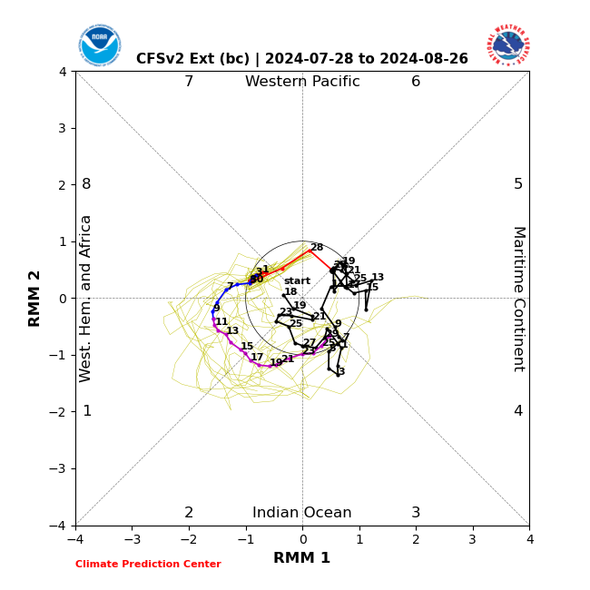
Just looking at CPC dynamic MJO from the various ensemble families, and it looks to stay quite weak but towards the maritime continent. I have found in neutral or weak ENSO that EWP can sometimes be useful, It would suggests a busy August.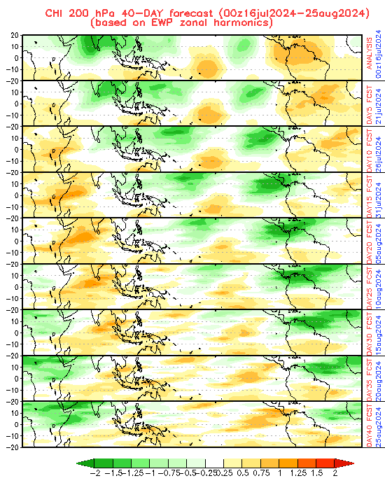
-
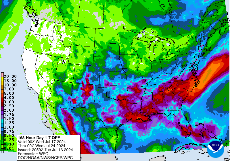
Texas 2024 Discussion/Observations
Ed, snow and hurricane fan replied to Stx_Thunder's topic in Central/Western States
The weakness in the ridge, aided by a weak cold front, should keep most of the state more rainy than normal for mid-July. Currently 95F here, should be near the afternoon high, lower 70F dewpoints are producing HI values around 100F, which isn't bad. And rain and lower than usual heights should help keep it cool.