Ed, snow and hurricane fan
-
Posts
2,133 -
Joined
-
Last visited
Content Type
Profiles
Blogs
Forums
American Weather
Media Demo
Store
Gallery
Everything posted by Ed, snow and hurricane fan
-

May 16 - June 4, 2024 Severe Weather
Ed, snow and hurricane fan replied to Quincy's topic in Central/Western States
Smallest ever MCD?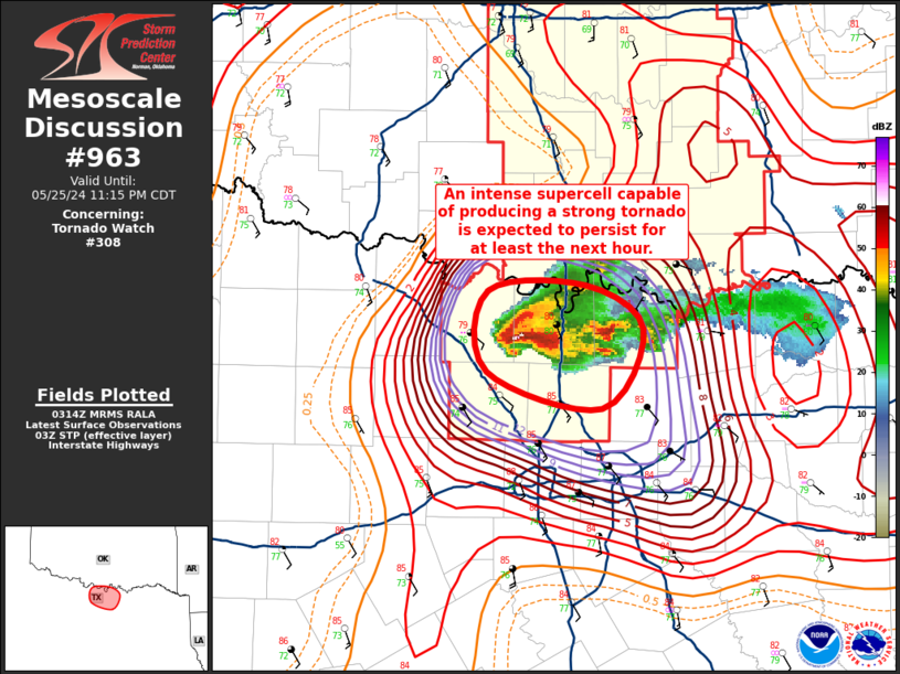
-
May 16 - June 4, 2024 Severe Weather
Ed, snow and hurricane fan replied to Quincy's topic in Central/Western States
Reed Timmer drove into a developing tornado E of Windthorst (bits of debris floating around, a couple of small vortices around him) on a dead ended dirt road. The tornado became fairly large about a minute after it passed him. It has taken him about 10 minutes to find a paved road again. Edit to Add: https://x.com/lorigraceaz/status/1794494190216519685 -
May 16 - June 4, 2024 Severe Weather
Ed, snow and hurricane fan replied to Quincy's topic in Central/Western States
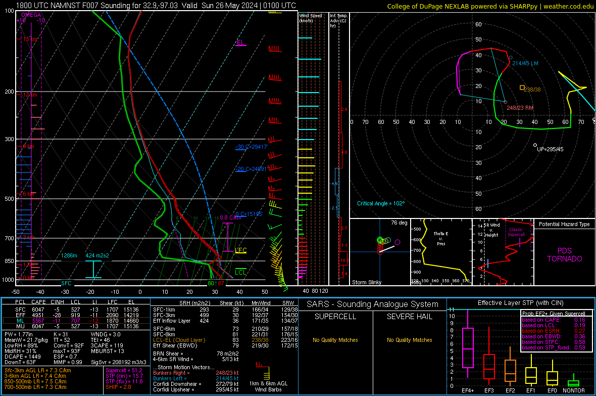
Speaking of the NAM, I'm pretty sure a forecast STP of 51 is probably top 10 all time.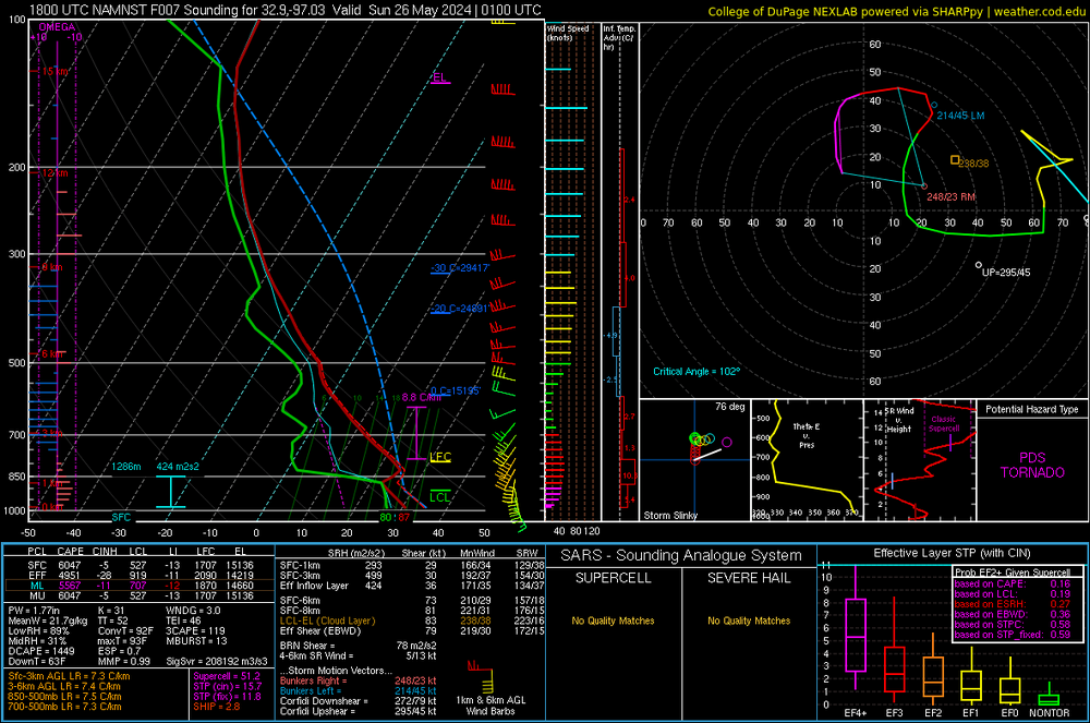
-
May 16 - June 4, 2024 Severe Weather
Ed, snow and hurricane fan replied to Quincy's topic in Central/Western States
HRRR shows nothing near I-20 and meanwhile a cell S of ABI showing a hook. -
May 16 - June 4, 2024 Severe Weather
Ed, snow and hurricane fan replied to Quincy's topic in Central/Western States
First dry line storm firing N of SJT. MCD issued. https://www.spc.noaa.gov/products/md/md0951.html -
May 16 - June 4, 2024 Severe Weather
Ed, snow and hurricane fan replied to Quincy's topic in Central/Western States
I'm hoping, although satellite shows the clouds burning off quickly, and it is only noon solar time. I can see where the dryline is now on vis. Nothing trying to develop, but cu are forming. -
May 16 - June 4, 2024 Severe Weather
Ed, snow and hurricane fan replied to Quincy's topic in Central/Western States
Which of the CAMs do you think is closest. I'm wondering whether the storms stay N of I-20 or get into the DFW Metroplex proper, my mother, sisters and nieces/nephews are in Euless. HRRR doesn't look that bad so far for DFW. -
Texas 2024 Discussion/Observations
Ed, snow and hurricane fan replied to Stx_Thunder's topic in Central/Western States
From about US 84 and S, it looks to get rather dry and quite warm. I think this is the beginning of summer in STX and the next real chance of significant rain is August, more likely September. Not sure the STR ever gets far enough N that we'll see inverted troughs breaking off from the jet and coming back W under the ridge. Land of pure speculation, next best chance for significant weather is probably in September when the STR breaks down enough for the return of rain producing fronts (not the weak wind shifts with small dewpoint drop that can make it here even mid-summer, but don't produce sensible weather because of high heights and subsidence. Good news, for customers whose 'weatherheads' (pipe that carries electric down to the house and external breaker box) aren't damaged, CenterPoint thinks most customers will have electricity by Wednesday. Which will be a good thing considering the heat. Low 90sF all week with dews above 70F. OTOH, in NTX, DFW is already in a 15% risk for severe storms on Thursday. They have probably 2 more weeks of spring before the high heights shut down spring.
-
2024 Atlantic Hurricane Season
Ed, snow and hurricane fan replied to Stormchaserchuck1's topic in Tropical Headquarters
Can't find the X post, which would save attachment usage, but the Equatorial and S Atlantic temps are trending cooler related to the MDR SSTs, or the AMM is going more positive. Which favors rising motion of the MDR, and lighter trades.
-
Texas 2024 Discussion/Observations
Ed, snow and hurricane fan replied to Stx_Thunder's topic in Central/Western States
Rain is ~10 miles away, near downtown by radar, but was outside, bright CG lightning, less than 3 miles away judging by the thunder. -
Texas 2024 Discussion/Observations
Ed, snow and hurricane fan replied to Stx_Thunder's topic in Central/Western States
My palm survived. NWS reporting just one tornado, near Cypress, preliminary EF-1. Cypress is where the big transmission lines (the reason 600,000 in the county are still in the dark are), I would have though EF-2 damage to take down transmission towers. https://x.com/TexasMoran/status/1791588419132617007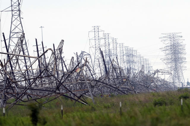
-
Texas 2024 Discussion/Observations
Ed, snow and hurricane fan replied to Stx_Thunder's topic in Central/Western States
We're lucky, The CenterPoint grid is not robust in our neighborhood, but we have power. Light flickered while the storm was still well W of here, with near calm winds. I'm guessing the transmission towers out by Cypress going down. Then again when the line hit. But they came on before the rain was even over. Before the second round of severe t-storm winds (not as strong as the first, but impressive) that surprised me because it had almost stopped raining. -
Texas 2024 Discussion/Observations
Ed, snow and hurricane fan replied to Stx_Thunder's topic in Central/Western States
There were Twitter posts showing CC drop at various locations. Cypress was one of those locations. Up to 700k CenterPoint customers w/o power. From X, a lot of people near Cypress posting images of these towers.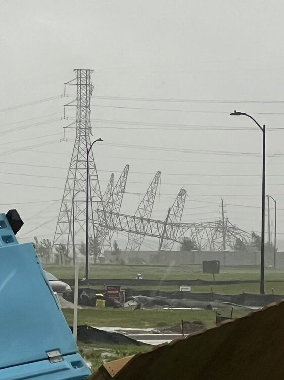
-
Texas 2024 Discussion/Observations
Ed, snow and hurricane fan replied to Stx_Thunder's topic in Central/Western States
Just had a brief ~20 second long wind gust, long past the storm. Just drops of water. Local KHOU has random pieces of debris, like a very large tree branch, downtown where there shouldn't be trees to lose large branches. Wife's tia has a tree down in her yard. -
Texas 2024 Discussion/Observations
Ed, snow and hurricane fan replied to Stx_Thunder's topic in Central/Western States
Someone else posted CC drop near Hockley, TX a few minutes ago with reports of trees snapped and uprooted and at least one house losing a roof. -
Texas 2024 Discussion/Observations
Ed, snow and hurricane fan replied to Stx_Thunder's topic in Central/Western States
The couplet is actually heading for my part of Harris County. -
Texas 2024 Discussion/Observations
Ed, snow and hurricane fan replied to Stx_Thunder's topic in Central/Western States
He has only 24 followers, but there was (still is) a warning in the area. -
Texas 2024 Discussion/Observations
Ed, snow and hurricane fan replied to Stx_Thunder's topic in Central/Western States
I'm still pretty sure the rain will be the bigger story. -
Texas 2024 Discussion/Observations
Ed, snow and hurricane fan replied to Stx_Thunder's topic in Central/Western States
This went in the wrong thread...
-
May 16 - June 4, 2024 Severe Weather
Ed, snow and hurricane fan replied to Quincy's topic in Central/Western States
T-Storm watch for Central Texas. Moderate hail/2 inch hail. Except Houston traffic, I should be done with a doctor appt. NW Houston (249/FM 1960 area) by 4 pm and HRRR suggests semi-discrete cells with STP AOA 4 and some impressive updraft helicities just a couple of counties NW of Houston. But I'm not driving US 290 anywhere near rush hour, and, having never chased before, and having to check my cell for radar while driving alone I'd have a decent chance of either destroying my car via hail or rear-ending someone, destroying my car, someone else's car, and possibly seriously injuring myself. So I'll come home and internet and check YouTube on the TV to see if anybody is chasing. I don't think I have ever seen anyone chasing near here. There is a 'Pastor Jaime G' ( @ StormChaserHTX) who gets high wind/heavy rain/lightning shots he shares with local broadcast media via social media. Maybe some Aggie met students, it may not be that far from CLL.
-
Texas 2024 Discussion/Observations
Ed, snow and hurricane fan replied to Stx_Thunder's topic in Central/Western States
Models are in fairly good agreement that the counties just N of the Houston metro will see the heavy rain. Or, where they need it least, they get the most. HRRR has some areas where the heaviest rain has fallen getting over 7 inches. W of here in the AUS and SAT areas, enhanced for hail seems likely for storms mid-afternoon. Tornado risk as well with fairly high SigTor's on 3 km NAM in the I-35 corridor in Central Texas. -
Texas 2024 Discussion/Observations
Ed, snow and hurricane fan replied to Stx_Thunder's topic in Central/Western States
PW that high usually happens in August and is usually associated with a tropical wave. 2.8" is fairly rare, even JAS. -
Texas 2024 Discussion/Observations
Ed, snow and hurricane fan replied to Stx_Thunder's topic in Central/Western States
Houston in a hatched hail for tomorrow. I've seen severe (quarter sized) hail just once in 25 years. I was driving home up 45, only time I have ever seen a supercell with an actual wall cloud. No obvious damage to my car, but that was loud. -
Texas 2024 Discussion/Observations
Ed, snow and hurricane fan replied to Stx_Thunder's topic in Central/Western States
I'm now in the rare (for us) tornado watch. We've had a couple of solid rain showers with thunder on the N side of Harris County, but nothing remotely close to severe limits. RAP sounding IMBY for 2 pm shows long, skinny CAPE, 50 knots of deep shear, but weak low level winds. 2.2 inch PW, looks more like a heavy rain sounding than anything severe. All models show heaviest rain well N of here, but perhaps close to Trinity River, which is well below peak but still above flood stage in SETX.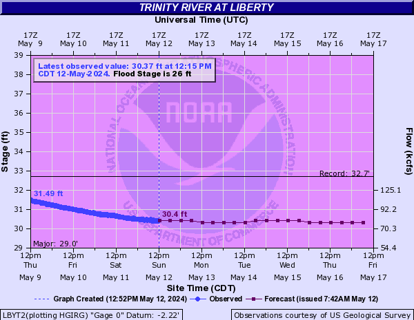
-
Texas 2024 Discussion/Observations
Ed, snow and hurricane fan replied to Stx_Thunder's topic in Central/Western States
Softball sized hail with a tornado warning for San Marcos. Been to a few tailgates there, Edward graduated last year from Texas State. No jumping in the river tonight...