Intensewind002
-
Posts
886 -
Joined
-
Last visited
Content Type
Profiles
Blogs
Forums
American Weather
Media Demo
Store
Gallery
Everything posted by Intensewind002
-
Is there any off chance that Ian could not make it to major hurricane status? If so how would that effect the storms future track?
-
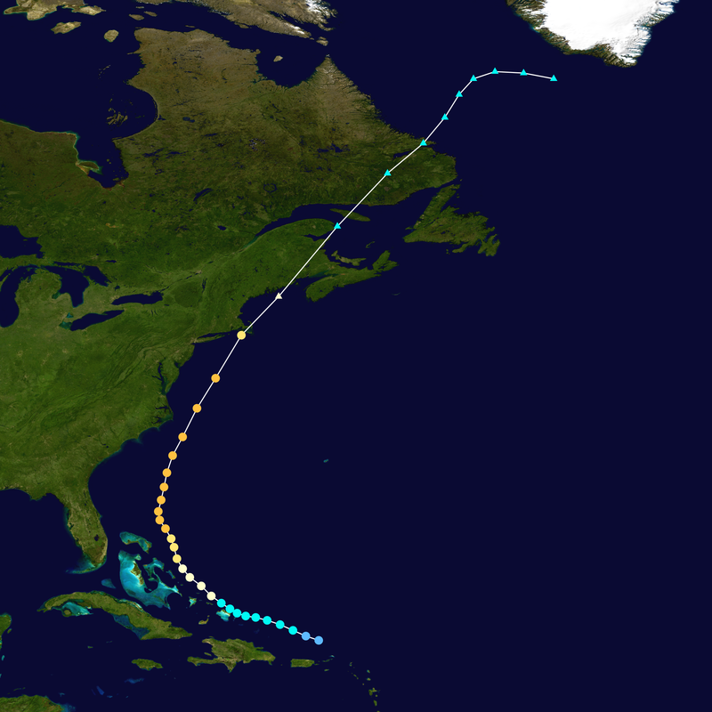
I’ve been thinking that this storm could have a lifecycle similar to 2002’s Hurricane Lili, but with a landfall a bit further east, they both occurred during the same time period too
-
I think i remember that, was kinda weird where like it would calm slightly between cells. And then after like a five minute break another light to moderate shower would move over and slam us with hurricane force wind gusts.
-
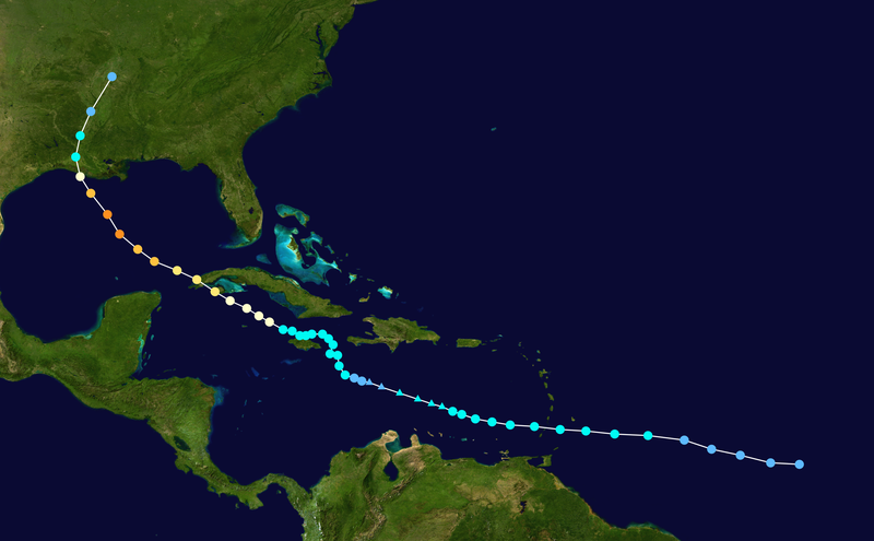
I found this on the CHC site for Cape Breton: Strong category-1 hurricane force winds of 100 gusting to 140 km/h at exposed locations except 140 gusting to 160 km/h at the coast with surge of 1.8 to 2.4 m and dangerous waves from 11 to 15 m from Hurricane Fiona are expected.
-
How exactly does a phase between a tropical cyclone and a trough happen? Can someone explain it to me?
-
Hurricane Lili might be a decent analog for this storm

-
That 18z gfs track was really similar to Edna from the same year

-
Convection is like a full 5 degrees Latitude farther east than the center of circulation at this point. Center reformation a possibility?
-
No storm will ever beat Hurricane Barry from a few years back in terms of ugliness, that thing was literally just a big rain band with literally no convection over or north of the center. How it managed to attain hurricane strength is a mystery of the universe considering I've seen 40 kt tropical storms that looked better
-

2022 Atlantic Hurricane season
Intensewind002 replied to StormchaserChuck!'s topic in Tropical Headquarters
I remember laughing at your prediction (in a friendly way lol) but then thinking “Imagine he’s right? What a coup that would be.” And here we are, with a 4/0/0 season so far. I had 21/9/4 and at this point I’m thinking there’s a better chance Long Island gets hit by a Cat 4 this year than that happening -
I’m surprised Islip has that much, I have 3.46” since June 1st from my pws. Only 0.92” since July 1
-
Only 0.01” of rain yesterday, only 0.24” for me this month. 0.80” since July 1st
-
Not much rain here last night .10”, .25” for this week though, around half the total I got in all of July
-
.16” of rain here, first time this month getting any accumulation
-
Holy crap, actual precipitation on the south shore of long island
-
Temp dropped slightly with the sea breeze, still 91/76
-
92/76 imby right now, heat index is currently 105
-
Only .02” of rain from my weather station last night. I’m in Virginia and last night i saw some heavy rain for the first time since like June. July finished with only around half an inch of rain imby
-
Finally past half an inch today with .15” this morning, .60” for the month now
-
So close yet so far

-
Maxxed out at 94 today, down to 90/70 now
-
I was only an 11 year old kid but I remember that being the hottest day I’ve ever experienced, it was like 102 with a dewpoint of 75. Heat index was like 115-120
-
Highs imby for the heatwave: Tuesday: 90 Wednesday: 94 Thursday: 86 (dewpoint of 78) Friday: 92 Today: 97
-
97/65 for the high here, easily the hottest day here since July 2020, the lack of humidity really helped. Temps have backed off to 94 now that the seabreeze has picked up. I would be in the pool rn if I didn’t get a nasty sunburn on Wednesday