Brian D
-
Posts
3,039 -
Joined
-
Last visited
Content Type
Profiles
Blogs
Forums
American Weather
Media Demo
Store
Gallery
Everything posted by Brian D
-
Found a new page under the "Climate and Past Weather" section (link is on the main forecast area page). You have access to data from various stns within the forecast zone. Very cool, and convenient. Worth checking out if you haven't seen it yet.

-
Scattered shwrs/stm moving through the area this morning.
-
May 24 1925: After seeing a high of 99 degrees two days earlier, the Twin Cities picks up a tenth (.10) of an inch of snow. 1908: Tornadoes hit the counties of Martin and Blue Earth. For Sunday, May 24, 2026 1894 - Six inches of snow blanketed Kentucky. Just four days earlier as much as ten inches of snow had fallen across Kentucky, Tennessee and Virginia. Six days earlier a violent storm had wrecked nine ships on Lake Michigan. (David Ludlum) 1930 - A tornado touched down near the town of Pratt, KS, and traveled at the incredibly slow speed of just 5 mph. (The Weather Channel) 1940 - Hail fell near Ada OK to a depth of six to eight inches, and rainfall runoff left drifts of hail up to five feet high. (The Weather Channel) 1987 - Severe thunderstorms in southwest Texas spawned a couple of tornadoes near Silverton, and produced golf ball size hail east of the town of Happy. Thunderstorms also produced large hail and damaging winds in Louisiana and Texas. (Storm Data) (The National Weather Summary) 1988 - Thunderstorms produced severe weather in the southeastern U.S. Thunderstorm winds gusted to 88 mph at Columbia, NC. Baseball size hail was reported near Tifton GA. (The National Weather Summary) (Storm Data) 1989 - Thunderstorms developing ahead of a cold front produced severe weather across the Upper Midwest through the day and night. Thunderstorms spawned 30 tornadoes, and there were 158 reports of large hail and damaging winds. A strong (F-3) tornado caused five million dollars damage at Corning, IA, and a powerful (F-4) tornado caused five million dollars damage at Traer, IA. Thunderstorm winds gusting to 88 mph killed one person and injured five others at Stephensville, WI. (The National Weather Summary) (Storm Data) 1990 - Severe thunderstorms spawned two dozen tornadoes from Montana to Oklahoma. Four tornadoes carved a 109-mile path across central Kansas. The third of the four tornadoes blew 88 cars of an 125-car train off the track, stacking them three to four cars high in some cases, and the fourth tornado caused 3.9 million dollars damage. The third tornado injured six persons who were trying to escape in vehicles. A woman was "sucked out" of a truck and said that at one time she was "airborne, trying to run but my feet wouldn't touch the ground". She also saw a live deer "flying through the air". (The National Weather Summary) (Storm Data)
-
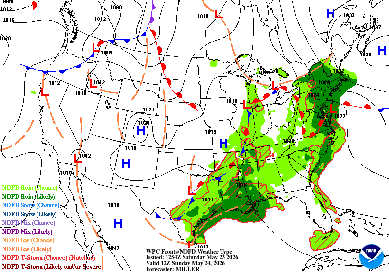
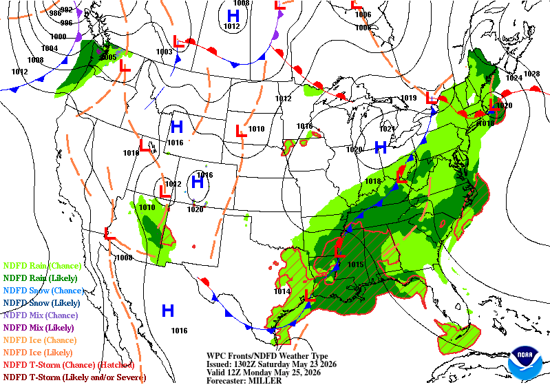
Did ok with this forecast. A little off in the above map for Monday, but thought that might be the case as main front is through the sub by then. Conditions improve from W to E over the weekend. Enjoy your weekend EV1!
-
Tops this list of 10 worst https://weather.com/storms/tornado/news/2019-04-12-ten-worst-tornadoes-in-us
-
May 23 1914: An early heat wave hits the state, with a high of 103 at Tracy. For Saturday, May 23, 2026 1882 - An unusual late season snow blanketed eastern Iowa, with four to six inches reported around Washington. (David Ludlum) (The Weather Channel) 1953 - The temperature at Hollis OK soared from a morning low of 70 degrees to an afternoon high of 110 degrees to establish a state record for the month of May. (The Weather Channel) 1987 - It was a busy day for thunderstorms in the central U.S. Thunderstorms produced wind gusts to 65 mph at Shreveport LA and golf ball size hail at Marfa, TX. Hobart, OK, received 3.55 inches of rain in the morning, and another 4.03 inches of rain that evening. Thunderstorms in Nebraska produced 8.5 inches of rain in two hours north of Potter, and 7.5 inches of rain in ninety minutes north of Minatare. Thunderstorms in Colorado produced five inches of hail at Greeley. (The National Weather Summary) (Storm Data) 1988 - Thunderstorms produced severe weather across much of the eastern U.S. Golf ball size hail was reported in Georgia, Maryland, North Carolina, South Carolina and Ohio. (Storm Data) (The National Weather Summary) 1989 - Severe thunderstorms developing along a cold front resulted in 98 reports of large hail and damaging winds in the Northern Plains and Upper Mississippi Valley. Golf ball size hail caused a million dollars damage around Buffalo City, WI, baseball size hail was reported at Northfield and Randolph, MN, and thunderstorm winds gusted to 95 mph at Dunkerton, IA. (The National Weather Summary) (Storm Data) 1989 - Unseasonably hot weather continued in the south central U.S. Pueblo, CO, equaled their May record with a high of 98 degrees, and the high of 106 degrees at Midland, TX, marked a record six straight days of 100 degree heat. (The National Weather Summary) 1990 - A cold front crossing the western U.S. produced snow over parts of Oregon, California, Nevada, Idaho and Utah, with five inches reported at Austin NV, and four inches at Crater Lake National Park in Oregon. Strong winds behind the cold front sharply reduced visibilities in blowing dust over central California, and two multi-vehicle accidents resulted in one death and eighteen injuries. In northern Idaho, a cloud-burst washed tons of topsoil, and rocks as large as footballs, into the valley town of Culdesac. (The National Weather Summary) (Storm Data)
-
Looks like 0.25 - 0.50" of rain around the area last night. 0.42" here in town.
-
All I can say is "About damn time!" https://www.federalregister.gov/documents/2026/05/07/2026-09099/request-for-comments-on-the-national-weather-service-cooperative-observing-program-coop
-
May 22 2011: A strong EF-1 tornado with wind speeds up to 110 mph strikes north Minneapolis, causing extensive tree and structural damage. The tornado touched down in St. Louis Park and moved through north Minneapolis, lasting 14.25 miles before dissipating in Blaine after causing minor damage to the Anoka County Airport. The tornado reached a peak width of 1/2 mile. 2001: Record cold high temperatures are set in over 30 cities in Minnesota, including a chilly 47 in the Twin Cities and 39 at Grand Rapids and Pine River. Half of an inch of snow falls at International Falls. 1925: Temperatures take a nosedive from 100 to 32 degrees in 36 hours at New Ulm and Tracy. For Friday, May 22, 2026 1876 - Denver CO was drenched with 6.53 inches of rain in 24 hours, an all-time record for that location. (The Weather Channel) 1911 - The temperature at Lewiston ME soared to 101 degrees. It was the hottest temperature ever recorded in New England during the month of May. (David Ludlum) 1987 - A powerful tornado virtually wiped the small southwest Texas community of Saragosa off the map. The twister destroyed eighty- five percent of the structures in the town killing thirty persons and injuring 121 others in the town of population 183. The tornado hurled trucks and autos through adobe and wood- frame homes, with some vehicles blown 500 feet. (The National Weather Summary) (Storm Data) 1988 - Thunderstorms produced severe weather over the Central Gulf Coast States. Tennis ball size hail was reported at Ripley MS. Showers and thunderstorms in southern Missouri produced 3.20 inches of rain at Springfield to easily surpass their rainfall record for the date. (The National Weather Summary) (Storm Data) 1989 - Unseasonably hot weather continued in southern Texas and parts of the southwestern U.S. Seven cities reported record high temperatures for the date, including El Paso TX with a reading of 100 degrees. Presidio TX was the hot spot in the nation with a high of 111 degrees. (The National Weather Summary) 1990 - Late afternoon and evening thunderstorms developing ahead of a cold front in the north central U.S. produced severe weather from northwestern Kansas to central Minnesota and southeastern North Dakota. There were twenty-nine reports of damaging winds, or dime to golf ball size hail. Strong thunderstorm winds gusted to 69 mph at Alexandria, MN. Showers and thunderstorms over eastern North Carolina soaked Wilmington with 2.91 inches of rain, which established a record for the date. (The National Weather Summary) (Storm Data)
-
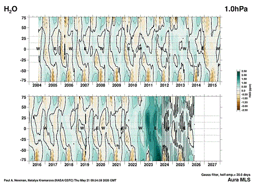
Found the site where stratospheric WV is shown at the various levels starting from the tropopause up to the top of the stratosphere. https://acd-ext.gsfc.nasa.gov/Data_services/met/qbo/h2o_mls.html My question is...Has the Hunga Tonga eruption in Jan 2022 greatly affected the climate system over the past few years with such a strong increase in WV within the stratosphere? We know that very large eruptions do affect the system for a few years, but this one was so different than the usual with such a large volume of WV injected so high up. It was awesome enough with the pressure waves circling the globe many times. Here's a slide show of the charts starting from the top down through the stratosphere into the tropopause.
-
May 21 1960: A downpour at New Prague dumps 10 inches of rain in a 48 hour period. For Thursday, May 21, 2026 1860 - A swarm of tornadoes occurred in the Ohio Valley. Tornadoes struck the cities of Louisville, KY, Cincinnati, OH, Chillicothe, OH, and Marietta, OH, causing a million dollars damage. (David Ludlum) 1895 - The temperature at Norwalk, OH, dipped to 19 degrees to set a state record for the month of May. (The Weather Channel) 1896 - The mercury soared to 124 degrees at Salton, CA, to establish a U.S. record for May. (Sandra and TI Richard Sanders - 1987) 1980 - The temperature at Williston ND reached 102 degrees to set a record for May, and the next day the mercury hit 106 degrees. (The Weather Channel) 1987 - Severe thunderstorms, developing along a sharp cold front crossing the central U.S., produced 60 mph winds and golf ball size hail at Sedalia, MO, and drenched Hagerstown, IN, with six inches of rain in one hour. Temperatures soared into the 90s ahead of the cold front. Paducah, KY, hit 94 degrees for the second day in a row. Light snow blanketed Montana, with three inches reported at Butte. (The National Weather Summary) (Storm Data) 1988 - Severe thunderstorms swept across southern Louisiana during the morning hours spawning six tornadoes, and producing wind gusts to 88 mph at Jennings. Thunderstorms also produced five inches of rain in two hours at Lake Charles, causing local flooding. (The National Weather Summary) (Storm Data) 1989 - Thunderstorms moving southeastward across the Central Plains Region into Oklahoma and Arkansas produced severe weather through the day and night. Thunderstorms spawned just four tornadoes, but there were 243 reports of large hail and damaging winds. Baseball size hail was reported at Augusta, KS, and thunderstorm winds gusted to 98 mph at Johnson, KS. (The National Weather Summary) (Storm Data) 1990 - Thunderstorms produced severe weather across the southeastern U.S. for the second day in a row. Severe thunderstorms spawned five tornadoes, including one which injured a person at Richmond KY. There were eighty-seven reports of large hail or damaging winds, with hail three inches in diameter reported at Austin TX. Thunderstorms produced up to five inches of rain in Macon County GA, and heavy rains left nearly eight feet of water over roads near Stepstone KY. (The National Weather Summary) (Storm Data)
-
Another chilly morning with temps in the mid 20's thru the 30's across NE MN. Looking forward to warmer temps starting next week. Heater still kicks on yet. I keep it on all year round. In the summer, a chilly morning can kick it on. Keeps the spider webs from collecting, and I know it'll run when the cold wx returns.
-
May 20 1892: Very late season snowfall hits central Minnesota. Maple Plain receives 4 inches of snow, with 3 inches falling in Minneapolis. This is the latest significant snow on record for the Twin Cities, and one of the latest widespread snowfalls in Minnesota. 1876: A tornado touches down near Ft. Ripley. For Wednesday, May 20, 2026 1894 - A record late snow of two to eight inches whitened parts of central and eastern Kentucky. Lexington KY received six inches of snow. (The Weather Channel) 1916 - A tornado struck the town of Codell, KS. A tornado struck the town on the same day the following year (1917), and a third tornado hit Cordell on May 20th in 1918. (The Weather Channel) Note: What are the odds of this happening?! 1957 - A tornado touched down to the southwest of Kansas City and traveled a distance of seventy-one miles cutting a swath of near total destruction through the southeastern suburbs of Ruskin Heights and Hickman Mills. The tornado claimed the lives of forty-five persons, and left hundreds homeless. It was the worst weather disaster of record for Kansas City. About all that remained of one house was a small table and a fish bowl atop, with the fish still swimming about inside the bowl, rather unconcerned. (The Kansas City Weather Almanac) 1987 - Thunderstorms in southern Texas produced grapefruit size hail, near the town of Dilley ("by dilly"), and produced wind gusts to 73 mph at Lake Amistad. The large hail broke windows, killed small animals, and damaged watermelon. Thunderstorms developing along a warm front produced severe weather from Indiana to the Dakotas. Thunderstorms produced baseball size hail at Denver IA, and wind gusts to 80 mph in southern Henry County IL. (Storm Data) (The National Weather Summary) 1988 - Thunderstorms in the south central U.S. produced wind gusts to 70 mph at Omaha, NE, and wind gusts to 80 mph at Midland and Dallas, TX. Temperatures in California soared into the 90s and above 100 degrees. San Jose CA reported a record high of 97 degrees. (The National Weather Summary) (Storm Data) 1989 - Pre-dawn thunderstorms produced large hail in eastern Oklahoma and northwestern Arkansas. Later in the morning thunderstorms in North Carolina produced dime size hail at Hanging Dog. Thunderstorms also produced severe weather from the Lower Mississippi Valley to the Central Plains Region later that day and night, with baseball size hail reported around Lawn, Novice and Eola TX. (The National Weather Summary) (Storm Data) 1990 - Thunderstorms produced severe weather across the southeastern quarter of the nation through the day and night. Severe thunderstorms spawned six tornadoes, including one which injured two persons at Algoma, MS, and another which injured nine persons at Rogersville, MO. There were 119 reports of large hail or damaging winds. Thunderstorms produced baseball size hail at Houston MO and damaging winds which killed one person at Toccoa GA. (Storm Data) (The National Weather Summary)
-
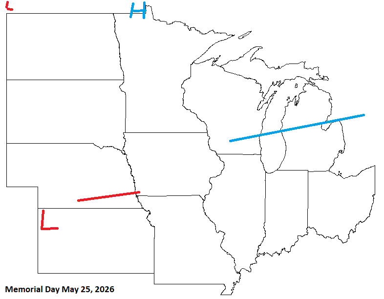
Lows ranging from the mid 20's to mid 30's this morning. Cool day in the 50's here in town. Basically 50's & 60's until Memorial day when a strong warm front starts to affect the W sub. Then summer wx arrives
-
For your area, yeah, but looking ok my way, except for Sat as of now. Saturday Showers likely. Mostly cloudy, with a high near 53. Northeast wind around 5 mph, with gusts as high as 20 mph. Saturday Night A slight chance of showers. Mostly cloudy, with a low around 42. Calm wind. Sunday Partly sunny, with a high near 65. Calm wind. Sunday Night Partly cloudy, with a low around 47. Calm wind. Memorial Day Mostly sunny, with a high near 70. Calm wind becoming south around 5 mph.
-
Looks like for the rest of May, the areas that really need the precip should see some improvement.


-
May 19 1975: Strong winds cause over 2 million dollars of damage across Fridley, Mounds View and New Brighton. For Tuesday, May 19, 2026 1780 - The infamous "dark day" in New England tradition. At noon it was nearly as dark as night. Chickens went to roost, and many persons were fearful of divine wrath. The phenomena was caused by forest fires to the west of New England. (David Ludlum) 1955 - Lake Maloya NM received 11.28 inches of rain in 24 hours to establish a state record. (The Weather Channel) 1975 - Thunderstorms produced golf ball size hail and wind gusts to 110 mph in Minnesota, between Fridley and Hugo. Fifty persons were injured. The hail and high winds destroyed fifty mobile homes, and a dozen aircraft, and also destroyed a third of the Brighton Elementary School. (The Weather Channel) 1987 - Thunderstorms in Texas produced thirteen inches of rain northwest of Lavernia. The heavy rain, along with golf ball size hail, destroyed eighty percent of the crops in the area, while high winds toppled trees. Golf ball size hail was also reported south of Dallas and around San Antonio. Up to eight inches of rain drenched Guadelupe County. (The National Weather Summary) (Storm Data) 1988 - Severe thunderstorms in southwest Texas produced hail as large as tennis balls around Midland, with the hail accumulating up to a foot deep. Showers and thunderstorms in the Middle Atlantic Coast Region produced 3.5 inches of rain near Schuylkill PA. (The National Weather Summary) (Storm Data) 1989 - Thunderstorms developing ahead of a cold front spawned ten tornadoes from Illinois to Tennessee during the afternoon and night. Snow, wind and cold prevailed in the Northern Plateau Region and the Northern Rockies. Dixie, ID, was blanketed with nine inches of snow, winds gusted to 87 mph at Choteau MT, and the temperature at Crater Lake, OR, dipped to 11 degrees. (Storm Data) (The National Weather Summary) 1990 - Thunderstorms deluged Hot Springs AR with thirteen inches of rain in nine hours resulting in a devastating flood. Two waves of water, four to six feet deep, swept down Central Avenue flooding stores and the famous bathhouses on Bathhouse Row. Water released from Lake Hamilton devastated the area between it and Remmel Dam. The 500 foot Carpenter Dam Bridge across Lake Catherine was completely washed away, as were cabins and mobile homes near the lake, many of which flowed right over the top of Remmel Dam. (The National Weather Summary) (Storm Data)
-
0.79" of rain from shwrs/stms last night. 0.98" for a 2 day total. That helps, but still sucking hind teet for May as we have only a 1/3 of the 3.30" avg. 6+" in April was great for catching up from the drier previous months. Update: Fire 100% contained. Looks like a power line started the fire. Section of Hwy 61 that was closed will be opened again later today approx 8 pm.
-
May 18 1980: Mt. St. Helens erupts. The smoke plume eventually rises to 80,000 feet, circling the earth in 19 days. Brilliant sunsets due to the smoke are seen over Minnesota for days afterward. Note: I remember this as a kid. The skies were pretty obscure for a while. An older friend of mine was in the MT mtns when it happened. He was a Green Beret in Vietnam. He heard the explosions, and thought the W coast was coming under a B-52 attack. He had no idea it was an eruption. 1933: Tornadoes hit McLeod and Mower counties. For Monday, May 18, 2026 1825 - A tornado said to have crossed all of the state of Ohio smashed into the log cabin settlement of Burlington, northeast of Columbus. (David Ludlum) 1960 - Salt Lake City UT received an inch of snow. It marked their latest measurable snowfall of record. (The Weather Channel) 1980 - Mount Saint Helens in Washington State erupted spewing ash and smoke sixty-three thousand feet into the air. Heavy ash covered the ground to the immediate northwest, and small particles were carried to the Atlantic coast. (David Ludlum) 1987 - Thunderstorms in Kansas, developing along a cold front, spawned tornadoes at Emporia and Toledo, produced wind gusts to 65 mph at Fort Scott, and produced golf ball size hail in the Kansas City area. Unseasonably hot weather prevailed ahead of the cold front. Pomona NJ reported a record high of 93 degrees, and Altus, OK, hit 100 degrees. (The National Weather Summary) (Storm Data) 1988 - Low pressure anchored over eastern Virginia kept showers and thunderstorms over the Middle Atlantic Coast Region. Flash flooding was reported in Pennsylvania. Up to five inches of rain drenched Franklin County PA in 24 hours. (The National Weather Summary) 1989 - Thunderstorms developing ahead of a cold front produced severe weather from the Central Gulf Coast States to the Lower Missouri Valley during the day and evening. Thunderstorms spawned sixteen tornadoes, and there were 74 reports of large hail and damaging winds. (The National Weather Summary) (Storm Data) 1990 - Thunderstorms produced severe weather in the central U.S. spawning a sixteen tornadoes, including a dozen in Nebraska. Thunderstorms also produced hail four inches in diameter at Perryton TX, wind gusts to 84 mph at Ellis KS, and high winds which caused nearly two million dollars damage at Sutherland NE. Thunderstorms deluged Sioux City IA with up to eight inches of rain, resulting in a record flood crest on Perry Creek and at least 4.5 million dollars damage. (The National Weather Summary) (Storm Data)
-
0.19" of rain last night. Very meager from what was expected. Cool, drizzly, foggy morning. Fire is 62% contained with 34 structures destroyed. Should be about done by tomorrow.
-
Cold morning inland with temps running in the 30's with some 20's. Ash Lake (SE of I-Falls) had a 24 reading.
-
May 17 1915: Old man winter's last hurrah dumps 5 inches of snow along the western shore of Lake Superior. For Sunday, May 17, 2026 1883 - A three day flood in the Black Hills of western South Dakota resulted in a million dollars damage at Rapid City. (David Ludlum) 1979 - A reading of 12 degrees at Mauna Kea Observatory established an all-time record low for the state of Hawaii. (The Weather Channel) 1983 - A golfer playing the Fox Meadows Course in Memphis TN was struck by a bolt of lightning that went through his neck, down his spine, came out a pocket containing his keys, and went into a nearby tree. Miraculously, he survived! (The Weather Channel) 1987 - A summer-like weather pattern continued, with warm temperatures and scattered thunderstorms across much of the nation. A cold front in the north central U.S. produced a sharp contrast in the weather across the state of Minnesota during the afternoon. At the same time Duluth was 50 degrees with rain and fog, Mankato was 95 degrees with sunny skies. (The National Weather Summary) 1988 - Thunderstorms produced large hail and damaging winds over the Carolinas during the afternoon and evening. A "thunderstorm of a lifetime" in northern Spartanburg County, SC, produced hail for forty-five minutes, leaving some places knee-deep in hail. (The National Weather Summary) (Storm Data) 1989 - Thunderstorms ravaged the south central U.S. with severe weather for the third day in a row. Thunderstorms spawned another nineteen tornadoes, for a total of fifty tornadoes in three days. A strong (F-2) tornado injured 14 persons and caused two million dollars damage at Apple Springs TX. Baseball size hail was reported at Matador TX. (The National Weather Summary) (Storm Data) 1990 - Thunderstorms developing along a cold front produced severe weather in New York State during the late morning and afternoon. A tornado injured one person at Warren, and wind gusts to 80 mph were reported at Owego. Evening thunderstorms over southwest Texas produced wind gusts to 80 mph at Marfa, along with golf ball size hail which accumulated to a depth of ten inches. Late night thunderstorms over southwest Texas produced up to seven inches of rain in western Crockett County. (The National Weather Summary) (Storm Data)
-
30% containment on the fire. Winds are switching to the NE off the Lake. Any flare ups could send sparks over the fire lines. But looks like plenty of rain tonight thru Tues a.m., so that should squash this thing.
-
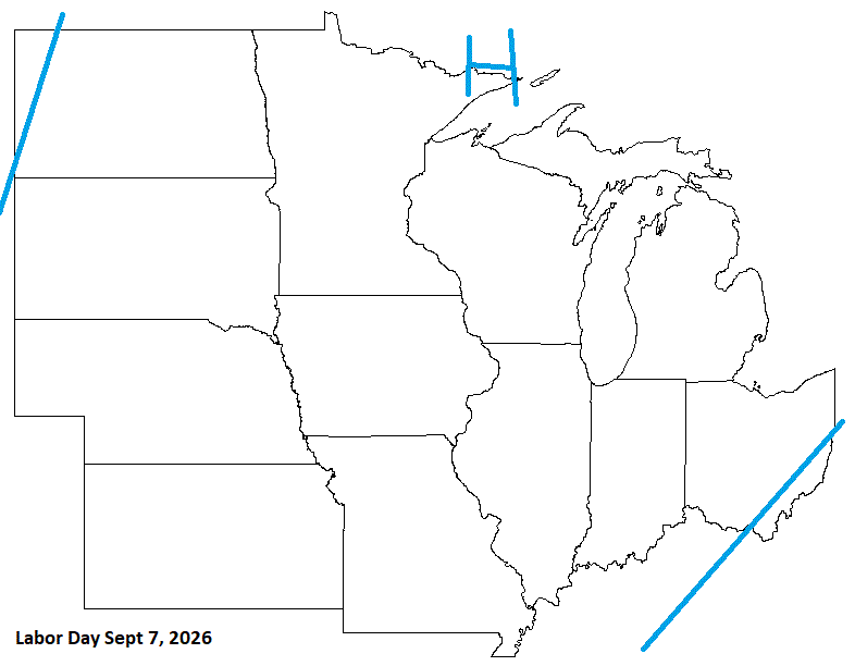
Labor Day is late this year, and looks pretty good. The weekend, tho, looks stormy.
-
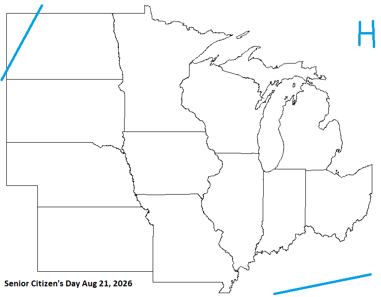
Senior Citizens Day Looks pretty decent.