MN Transplant
-
Posts
17,493 -
Joined
-
Last visited
Content Type
Profiles
Blogs
Forums
American Weather
Media Demo
Store
Gallery
Everything posted by MN Transplant
-
Really nice out this morning with a breeze and 70/60.
-
2023 Mid-Atlantic Severe Wx Thread (General Discussion)
MN Transplant replied to Kmlwx's topic in Mid Atlantic
I can hear your cell grumbling from the western side of the Beltway. 0.11" today, so a miss, but we have done plenty well over the last two months.- 2,785 replies
-
- 1
-

-
- severe
- thunderstorms
- (and 3 more)
-
2023 Mid-Atlantic Severe Wx Thread (General Discussion)
MN Transplant replied to Kmlwx's topic in Mid Atlantic
Wild that the main stripe and NW cutoff were in eerily similar positions as yesterday. -
2023 Mid-Atlantic Severe Wx Thread (General Discussion)
MN Transplant replied to Kmlwx's topic in Mid Atlantic
We’ve had a run of later summer severe in the last several years. It is making up for about nothing in Apr/May.- 2,785 replies
-
- 1
-
-
- severe
- thunderstorms
- (and 3 more)
-
2023 Mid-Atlantic Severe Wx Thread (General Discussion)
MN Transplant replied to Kmlwx's topic in Mid Atlantic
Kudos to LWX to hit the Flash Flood Warning early. I was skeptical based on radar, but these are efficient as hell. I’m at 0.61” despite being on the periphery.- 2,785 replies
-
- 3
-
-
- severe
- thunderstorms
- (and 3 more)
-
2023 Mid-Atlantic Severe Wx Thread (General Discussion)
MN Transplant replied to Kmlwx's topic in Mid Atlantic
@yodaand @H2O Looking good for you.- 2,785 replies
-
- 1
-
-
- severe
- thunderstorms
- (and 3 more)
-
2023 Mid-Atlantic Severe Wx Thread (General Discussion)
MN Transplant replied to Kmlwx's topic in Mid Atlantic
(Insert La Plata comment here)- 2,785 replies
-
- 4
-

-
-
- severe
- thunderstorms
- (and 3 more)
-
At least you aren't west of Dulles.

-
I should have posted this one in here.
-
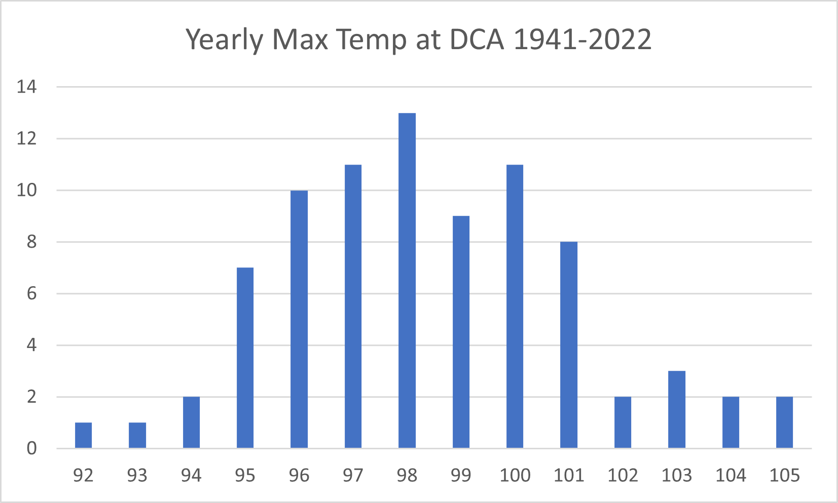
People went too high for most summers. It is a minority of years that hit 100.
-
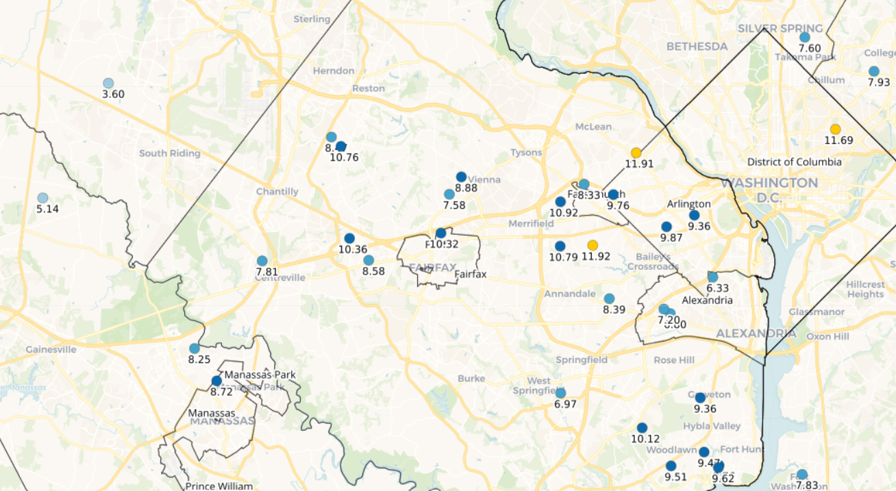
Over a half inch, which takes me to nearly 11" since July 1st. Quite the turnaround from that dud of a first half of the year.
-
The accurate readings from south FL are bad enough. 94/80 as a ballpark reading.
-
12z NAM Nest did have some showers around. 0.05” here
-
We are planning on that trip sometime in the next 5 years. Are you happy with the time of year?
-
Raining. Interesting.
-
1.56”, with the majority coming in the 11pm downpour. Over 2” when adding in the prior day.
-
2023 Mid-Atlantic Severe Wx Thread (General Discussion)
MN Transplant replied to Kmlwx's topic in Mid Atlantic
Little cell merger about to happen west of Stafford- 2,785 replies
-
- 2
-
-
- severe
- thunderstorms
- (and 3 more)
-
2023 Mid-Atlantic Severe Wx Thread (General Discussion)
MN Transplant replied to Kmlwx's topic in Mid Atlantic
- 2,785 replies
-
- 8
-
-
- severe
- thunderstorms
- (and 3 more)
-
2023 Mid-Atlantic Severe Wx Thread (General Discussion)
MN Transplant replied to Kmlwx's topic in Mid Atlantic
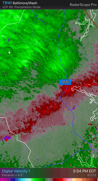
The striations in the TBWI data are fun.- 2,785 replies
-
- 1
-
-
- severe
- thunderstorms
- (and 3 more)
-
2023 Mid-Atlantic Severe Wx Thread (General Discussion)
MN Transplant replied to Kmlwx's topic in Mid Atlantic
Power outages tame closer into DC in Virginia, but more extensive out by Marshall/Markham/Delaplane/Upperville with that cell from earlier. DCA to 52mph.- 2,785 replies
-
- 1
-
-
- severe
- thunderstorms
- (and 3 more)
-
2023 Mid-Atlantic Severe Wx Thread (General Discussion)
MN Transplant replied to Kmlwx's topic in Mid Atlantic
There's a reason why SPC talks about "within 25 miles". There just aren't many events that pan out other than in very localized places. We're seeing it here with Westminster and others. In Fairfax County, we are going to see a small stripe of damage from Manassas to the east, but nothing else. I also gusted in the 20s and the rain is actually not impressive for how the radar looks. Big drop bias.- 2,785 replies
-
- 4
-
-
- severe
- thunderstorms
- (and 3 more)
-
2023 Mid-Atlantic Severe Wx Thread (General Discussion)
MN Transplant replied to Kmlwx's topic in Mid Atlantic
Round 2 entering VA. HRRR says we storm again around 9pm. -
2023 Mid-Atlantic Severe Wx Thread (General Discussion)
MN Transplant replied to Kmlwx's topic in Mid Atlantic
Manassas airport gusted to 59- 2,785 replies
-
- 2
-
-
- severe
- thunderstorms
- (and 3 more)
-
2023 Mid-Atlantic Severe Wx Thread (General Discussion)
MN Transplant replied to Kmlwx's topic in Mid Atlantic
Mattie's out of town and this thing is headed right to Burke. LOL.- 2,785 replies
-
- 3
-
-
- severe
- thunderstorms
- (and 3 more)