MN Transplant
-
Posts
17,845 -
Joined
-
Last visited
Content Type
Profiles
Blogs
Forums
American Weather
Media Demo
Store
Gallery
Everything posted by MN Transplant
-
6-hourlies: DCA: 87 IAD: 90 BWI: 91 I am currently at 89.1
-
BWI already has 90. IAD is right up against it. DCA needs a off-river kick. 88.7 is my high so far
-
DCA 78 with a river wind IAD 84 BWI’s hourly isn’t in yet but probably 86/87 82.9 at home
-
Warm. A tad bit humid too. Of course, we’ll be begging for 60 degree dews in a month or two.
-
And Dallas Turner (edge), who was the #1 defender on many boards. Not much draft capital left this year and next, but a good foundation for future years.
-
The NFL draft can't start soon enough. The Vikings fandom is going insane with the QB question.
-
The 5-minute obs haven't been coming in since 2am. But you are right, the 62 high is 5 degrees warmer than any of the local stations. I've only been to 54 today.
-
Month to date after the warm spell. Not going to erase these, so it'll be another + month. DCA +3.7 BWI +4.0 IAD +5.4
-
But that link has nothing to do with growing season. It is about what can survive based off of the coldest temperatures of the winter. You know, don’t plant a mango tree in Vermont. I haven’t seen anything from USDA that tells you when to put tomatoes out. Now, some seed companies may use the zones as proxies to give you a general timeline, but they also usually caveat that with plant specific guidelines.
-
What calendars did they put out? I only know the hardiness zones which is about wintering over.
-
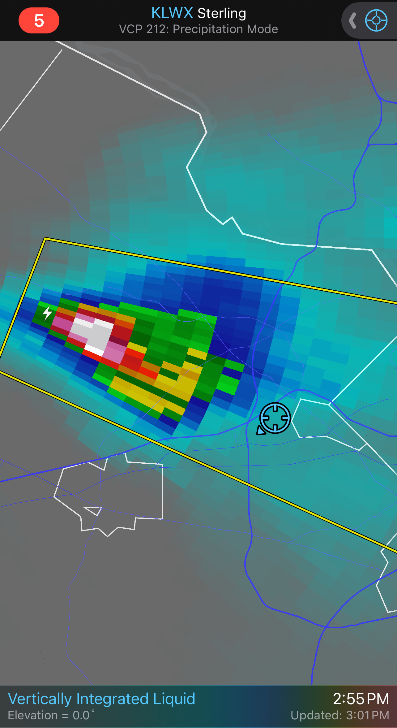
Hydrometeor classification on that one is "giant hail"
- 1,696 replies
-
- 1
-

-
- severe
- thunderstorms
- (and 5 more)
-
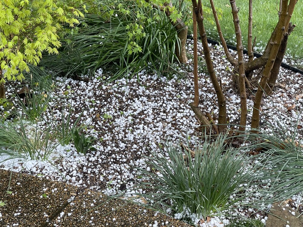
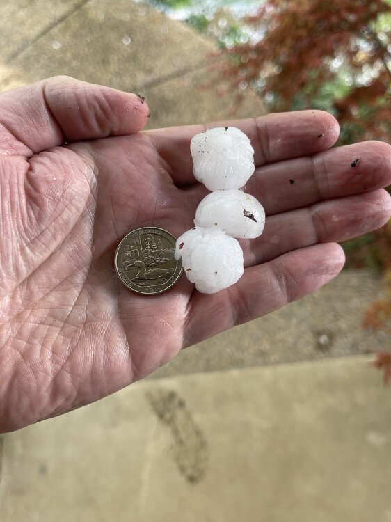
Quarter plus. I’m scouting the field for bigger.
- 1,696 replies
-
- 1
-

-
- severe
- thunderstorms
- (and 5 more)
-
- 1,696 replies
-
- 14
-
-
- severe
- thunderstorms
- (and 5 more)
-
Best hail in my 20 years in the DC area. Pea to marble
- 1,696 replies
-
- 6
-
-
- severe
- thunderstorms
- (and 5 more)
-
You aren’t kidding.

- 1,696 replies
-
- 1
-
-
- severe
- thunderstorms
- (and 5 more)
-
Yeah, I hadn’t checked in a while. Been to 84.9 here!
-
84/42 at IAD. +17 for the high, and -1 for the low. Looks like another easily above normal month.
-
Torch
-
0.29", which is fine since we are doing well so far this year.
-
April 8th Eclipse- Last Easy One To See In My Lifetime
MN Transplant replied to Interstate's topic in Mid Atlantic
I wondered about the local businesses too. I think it was the gas stations (especially the ones with food) and hotels that really profited. -
April 8th Eclipse- Last Easy One To See In My Lifetime
MN Transplant replied to Interstate's topic in Mid Atlantic
Adding to this, while the extra length is nice, you don’t have to be center line to enjoy totality. -
April 8th Eclipse- Last Easy One To See In My Lifetime
MN Transplant replied to Interstate's topic in Mid Atlantic
The red spot was a really interesting part of the experience. Evidently we did see a prominence. In my view it was at about 7 o’clock on the sun’s ring. https://x.com/forecaster25/status/1777434179136819497?s=46&t=bA1Os5w_10i9PfsurY28aw -
April 8th Eclipse- Last Easy One To See In My Lifetime
MN Transplant replied to Interstate's topic in Mid Atlantic
That was awesome -
April 8th Eclipse- Last Easy One To See In My Lifetime
MN Transplant replied to Interstate's topic in Mid Atlantic
Made it to Malone, NY. Milky skies, but better than I expected last night. Curious how much corona I’ll get to see. -
April 8th Eclipse- Last Easy One To See In My Lifetime
MN Transplant replied to Interstate's topic in Mid Atlantic
The upper level cirrus isn’t bad at all in Syracuse. We might try to outrun the mid level deck.