

MN Transplant
-
Posts
17,854 -
Joined
-
Last visited
Content Type
Profiles
Blogs
Forums
American Weather
Media Demo
Store
Gallery
Everything posted by MN Transplant
-
I don't think I've experience 40:1 outside of the upper Midwest, but it is at least in the realm of possibility. We effectively did 20:1 in early December this winter and that wasn't a crazy airmass. It is just fluff at those ratios.
-
January 24-26: Miracle or Mirage OBS Thread!
MN Transplant replied to Jebman's topic in Mid Atlantic
The ~2" of sleet that I just shoveled was heavier than the 5" of snow that I did this morning. It makes sense water content-wise, but it is still wild. 18.0 degrees and rising slowly. -
January 24-26: Miracle or Mirage OBS Thread!
MN Transplant replied to Jebman's topic in Mid Atlantic
The surface temps are running well below guidance, at least IMBY (16.4°) which makes me wonder if the cold layer is going to hold on long enough to reduce the ZR chances. -
January 24-26: Miracle or Mirage OBS Thread!
MN Transplant replied to Jebman's topic in Mid Atlantic
Still just 14.4°. It looks like I got another 0.5" from that mix between 7-8:30am before going over to full sleet. So, sitting at about 5.8", with 5.5" snow and 0.3" sleet. One thing, as everyone has noticed, is that the sleet is very dry. I'm guessing that the depth of the cold layer helped to completely refreeze the sleet without some of the residual "softness" that normally makes it sticky. Might end up being beneficial for travel over the next few days, ZR-dependent. -
January 24-26: Miracle or Mirage OBS Thread!
MN Transplant replied to Jebman's topic in Mid Atlantic
I'm not seeing any plain rain on the GFS except for over east of the Bay. Sometimes the error isn't the model itself but how the individual providers display it. -
January 24-26: Miracle or Mirage OBS Thread!
MN Transplant replied to Jebman's topic in Mid Atlantic
It won't be long. Vis rapidly increased here and I'm mostly sleet. -
January 24-26: Miracle or Mirage OBS Thread!
MN Transplant replied to Jebman's topic in Mid Atlantic
NAM was shockingly low with the precip, but the thermals were good. Still technically snow here, but it is getting louder as it is icy/rimed. -
January 24-26: Miracle or Mirage OBS Thread!
MN Transplant replied to Jebman's topic in Mid Atlantic
5.0” on 0.56” precip. So we scored on the precip and the ratios were bad. As is evidenced by my mesh outdoor furniture not collecting snow at all with tiny snow grains. (Actual snowboard location in fencing above dog).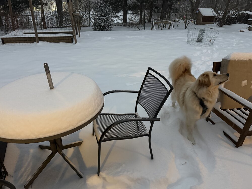
-
January 24-26: Miracle or Mirage OBS Thread!
MN Transplant replied to Jebman's topic in Mid Atlantic
Watching the temp/DP come together at 13 degrees is much more fun than 34. -
Jan 24-26 Weekend Snow and Sleetfest Model Thread Part Tres
MN Transplant replied to H2O's topic in Mid Atlantic
HRRR continues to advertise a later flip than the NAM. More like 15z/10am in DC. Rates are always important, but it’ll kill us if we lose the column by 7am. -
January 24-26: Miracle or Mirage OBS Thread!
MN Transplant replied to Jebman's topic in Mid Atlantic
Looking great! Edit - Johnson City, TN is the line right now -
January 24-26: Miracle or Mirage OBS Thread!
MN Transplant replied to Jebman's topic in Mid Atlantic
TDWR base scans are 0.3 degrees and the WSR-88Ds are 0.5. So, closer and lower to the ground is normally best. However, the 88Ds are more powerful. I still defer to them in light snow. -
Jan 24-26 Weekend Snow and Sleetfest Model Thread Part Tres
MN Transplant replied to H2O's topic in Mid Atlantic
The Canadians finally thawed. 12z GDPS seems healthy precip wise. Guessing a 14Z changeover after maybe 0.7"? 12z RDPS either had something wrong with the run or with the transmission. Not on Pivotal, but it is partially on College of Dupage. Same 14z changeover timing. No precip amounts available, but looks healthy from the precip rate/type maps. -
Jan 24-26 Weekend Snow and Sleetfest Model Thread Part Tres
MN Transplant replied to H2O's topic in Mid Atlantic
I have just enough knowledge of this to be dangerous, but high risk can correct me. Models have a dynamical core and various physics packages. About a decade ago NOAA/NWS decided to try to align all of the operational models with a single dynamical core. The FV3 was chosen but there have been some problems with it when it is run at finer convection-allowing resolution. So, the alternative was MPAS (model for prediction across scales) from NCAR. I know that NSSL has been testing out MPAS a lot and that one may end up being the dynamical core. One of the problems with MPAS, though, is that it is computing-hungry compared to FV3. So, NOAA is weighing pros and cons. -
Jan 24-26 Weekend Snow and Sleetfest Model Thread Part Tres
MN Transplant replied to H2O's topic in Mid Atlantic
A touch of ZR at the end of the NAM Nest run, but mostly just drier. 1" QPF, pretty similar to this morning's run. -
Jan 24-26 Weekend Snow and Sleetfest Model Thread Part Tres
MN Transplant replied to H2O's topic in Mid Atlantic
Still the NAM -
Jan 24-26 Weekend Snow and Sleetfest Model Thread Part Tres
MN Transplant replied to H2O's topic in Mid Atlantic
NAM 3k is a hold or worse for DC. Blasts the mix line through between 12z-13z, with maybe 0.3" QPF by then. -
Jan 24-26 Weekend Snow and Sleetfest Model Thread Part Tres
MN Transplant replied to H2O's topic in Mid Atlantic
I think everything is colder than the NAMs, thankfully. -
Jan 24-26 Weekend Snow and Sleetfest Model Thread Part Tres
MN Transplant replied to H2O's topic in Mid Atlantic
18Z HRRR looks ok as long as you have reasonable expectations. DC loses the column just prior to 15Z with about 0.50" QPF. -
Jan 24-26 Weekend Snow and Sleetfest Model Thread Part Tres
MN Transplant replied to H2O's topic in Mid Atlantic
Disasterclass by the GFS in the past few days. From a weak 850 low that let the cold hang in, to an 850 low near Clev/Pitt like every other model had.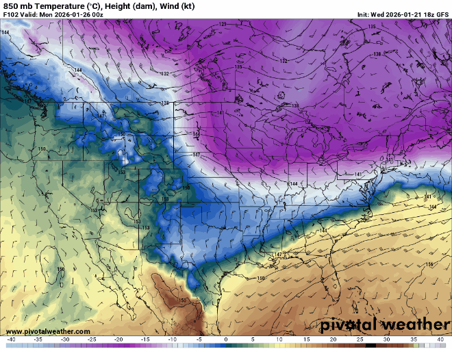
-
Jan 24-26 Weekend Snow and Sleetfest Model Thread Part Tres
MN Transplant replied to H2O's topic in Mid Atlantic
ICON 10:1 trend. Slight north bleed, but serious consistency.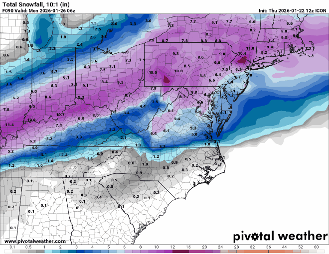
-
Jan 24-26 Weekend Snow and Sleetfest Model Thread Part Tres
MN Transplant replied to H2O's topic in Mid Atlantic
Hard to tell with 6-hr panels, but the ICON looks like ~15Z changeover and maybe 0.5-0.6" QPF by then. 10:1 snow maps look like a hold from 06z. Edit - if you want consistency, the 10:1 snowfall on the ICON through 18z has been between 5 and 6" for DC for the past 7(!) runs. -
January 24-26: Miracle or Mirage JV/Banter Thread!
MN Transplant replied to SnowenOutThere's topic in Mid Atlantic
I really hope we don't have to cut the NAM precip by 1/3rd like we used to! -
Jan 24-26 Weekend Snow and Sleetfest Model Thread Part Tres
MN Transplant replied to H2O's topic in Mid Atlantic
The RRFS doesn't even look plausible with the precip shield, but it is ~0.4" in DC before the flip. -
January 24-26: Miracle or Mirage JV/Banter Thread!
MN Transplant replied to SnowenOutThere's topic in Mid Atlantic
It isn't necessarily whether the NAM is correct, it is that we'd hope to be narrowing the goalposts by this period. I wanted to see the NAM come back to the fold, not double down.


