MN Transplant
-
Posts
17,859 -
Joined
-
Last visited
Content Type
Profiles
Blogs
Forums
American Weather
Media Demo
Store
Gallery
Everything posted by MN Transplant
-
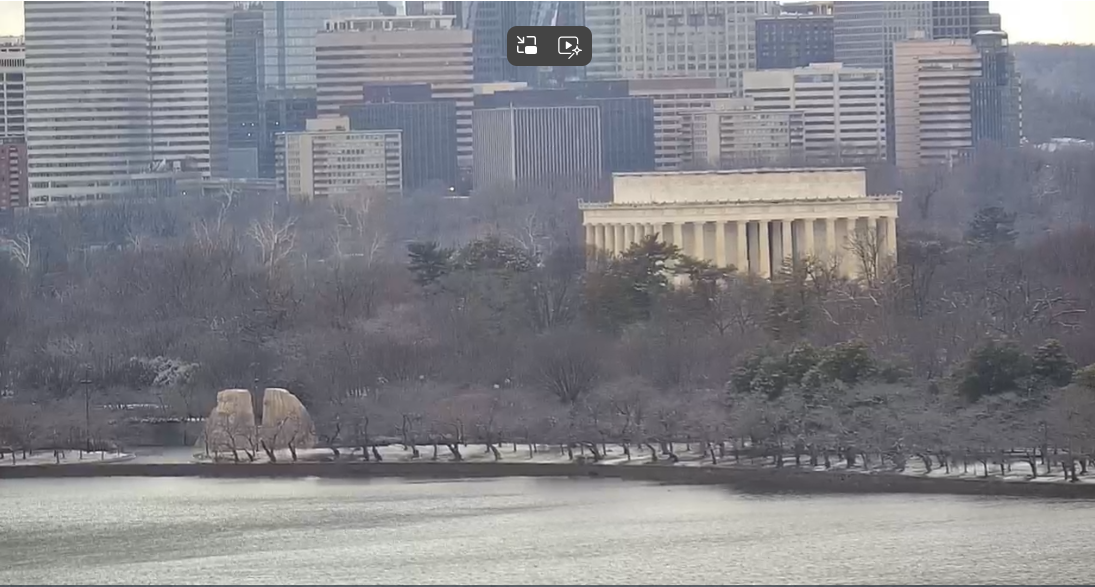
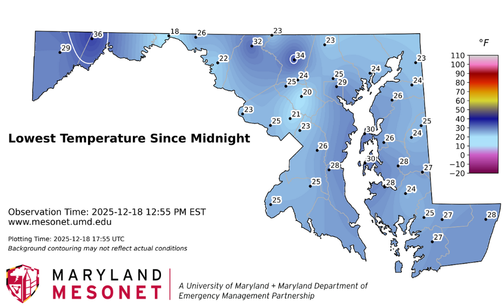
You weren't kidding, what an inversion last night. IAD at 23 and my low was 35. I'm not sure when I've ever been up on DCA by 7 degrees for a low. On the MD Mesonet, the warmest site was Frostburg at nearly 2300'.
-
Models had it pegged that it would be flat overnight as the overall airmass moderated. My 14.2 low was at 12:39am.
-
19.6 and the wild is howling
-
12/14: Sunday funday? Will the south win again?
MN Transplant replied to TSSN+'s topic in Mid Atlantic
QPF was good around here, but it should have been a bigger warning sign that Kucera was less than 10:1. -
12/14: Sunday funday? Will the south win again?
MN Transplant replied to TSSN+'s topic in Mid Atlantic
Ground is barely whitened and the trees don't have much. At least at my elevation (~450') it stuck to the trees. DCA's measurements always seem suspect, but for the most part they are reality.
-
12/5 - 1.9" 12/14 - 1.3" Total - 3.2"
-
12/14: Sunday funday? Will the south win again?
MN Transplant replied to TSSN+'s topic in Mid Atlantic
Yeah, some, but not a lot. Weirdly, it balances out the extremely high ratio snow from last week to the point where I’m nearly 10:1 on the season. -
12/14: Sunday funday? Will the south win again?
MN Transplant replied to TSSN+'s topic in Mid Atlantic
1.3” on 0.25” precip. Putrid ratios -
12/14: Sunday funday? Will the south win again?
MN Transplant replied to TSSN+'s topic in Mid Atlantic
We are still 6 hours away from snow in the DC beltway. -
12/14: Sunday funday? Will the south win again?
MN Transplant replied to TSSN+'s topic in Mid Atlantic
At one point the HRRR wanted to pump us to the mid-upper 40s. I topped out at 42 also. -
12/14: Sunday funday? Will the south win again?
MN Transplant replied to TSSN+'s topic in Mid Atlantic
RRFS is a dud for Virginia but looks good north of Baltimore. -
12/14: Sunday funday? Will the south win again?
MN Transplant replied to TSSN+'s topic in Mid Atlantic
10:1 maps are higher than Kucera on the NAM in this case. I'd take the lower amounts. -
12/14: Sunday funday? Will the south win again?
MN Transplant replied to TSSN+'s topic in Mid Atlantic
5pm Sunday wind chills of -5 to +5. Get your stuff done today. -
12/14: Sunday funday? Will the south win again?
MN Transplant replied to TSSN+'s topic in Mid Atlantic
Ends up about identical to 6z around DC. 2" -
12/14: Sunday funday? Will the south win again?
MN Transplant replied to TSSN+'s topic in Mid Atlantic
It snows for maybe 2 hours IMBY on the 6z 3k. -
12/14: Sunday funday? Will the south win again?
MN Transplant replied to TSSN+'s topic in Mid Atlantic
Everyone is appropriately focused on the precip chances, but the temperature trend is looking like it will be unusual. The core of the cold sweeps in during the day Sunday and we are in deep winter by evening with temps somewhere around 20 and breezy conditions. But then the airmass begins to moderate and we flatline overnight into Monday. -
12/14: Sunday funday? Will the south win again?
MN Transplant replied to TSSN+'s topic in Mid Atlantic
I think we're semi-cooked on this one. It just frankly doesn't snow for very long on any of the models and it isn't like this is a juiced up event. We'll try again in January. -
12/14: Sunday funday? Will the south win again?
MN Transplant replied to TSSN+'s topic in Mid Atlantic
Forget north/south, it is 95 vs everyone else -
16.0. This is a cold December so far.
-
Thank you Washington for the confidence-builder for McCarthy. I still doubt he’s the guy, but it is good to see.
-
That bridge shot is fantastic
-
12/5 - 1.9"
-
Lol, I did the same thing. I only had 0.08" in my CoCoRahs gauge which is usually dead-on when it isn't windy. Then I took a core sample and only got a little more. I think I'm going to go with 1.8" on 0.09" precip for a 20:1 ratio. So, we busted low on precip but it didn't matter.
-
1.2”. That band was excellent.
-
Loudoun made a late call to close