MN Transplant
-
Posts
17,625 -
Joined
-
Last visited
Content Type
Profiles
Blogs
Forums
American Weather
Media Demo
Store
Gallery
Everything posted by MN Transplant
-
Winter 2021-2022 Digital Snow Thread
MN Transplant replied to NorthArlington101's topic in Mid Atlantic
These are some of the best Digital Snow maps in the past decade. -
Howard finally won.
-
That tuck and stall is…mwah.
-
Broke below 20, but what a dud of a temp trace.
-
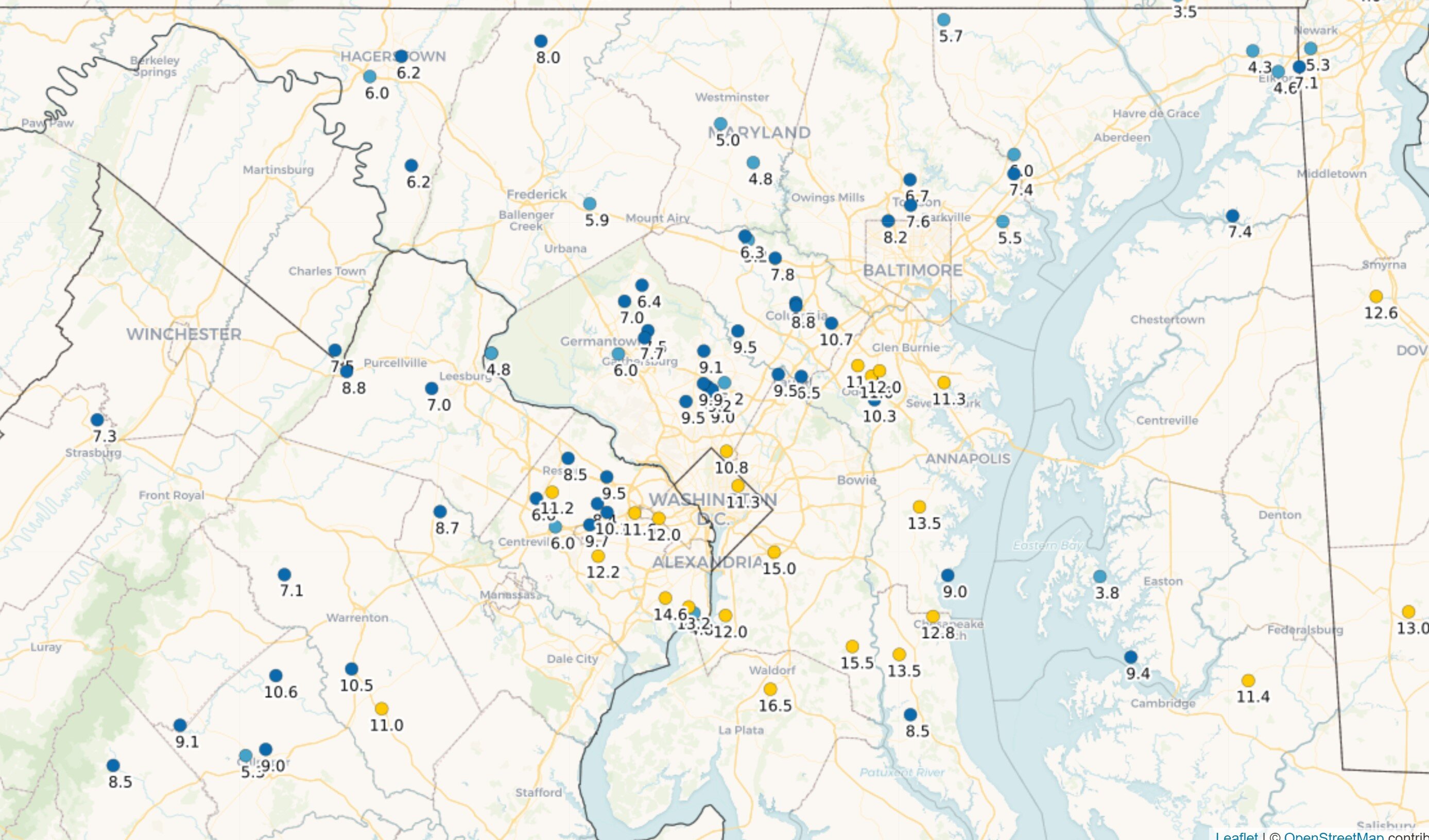
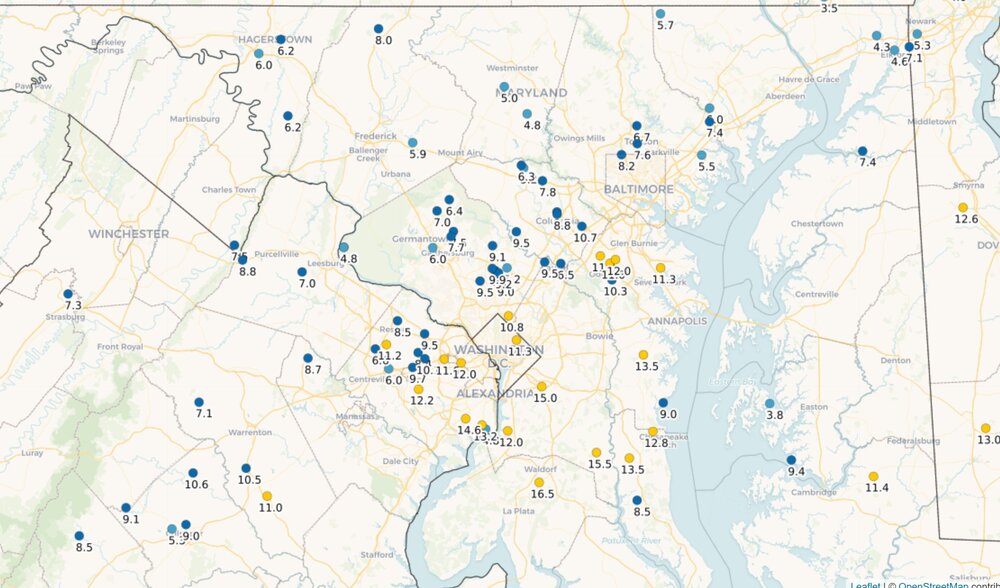
Snowfall for the week. CoCoRahs.
-
Mid-Atlantic forum winter 2021/22 snow totals thread
MN Transplant replied to North Balti Zen's topic in Mid Atlantic
Falls Church, VA 1/3/22 - 8.8" 1/7/22 - 2.8" Total: 11.6" -
2nd best start to a winter by that metric (through 1/7) since moving to my house in 2009. 09/10 - 22.0" 21/22 - 11.6" 13/14 - 6.5"
-
Excellent wintry day with the snow blowing around.
-
That’s strange. They should send out an explanation when something like that happens.
-
Yup. And usually I’m leery of the ASOS precip totals in snowfall, but that was almost dead on with mine (2.8”/0.20).
-
Another factor in the model discussion is the ratios. This was a very high ratio storm around here for us. None of the models really do that well, even using Kuchera. DCA/IAD/BWI were all under .25” of precip. The GFS was by far the worst model in this regard.
-
2.8” new on 0.20” precip in Falls Church, so good ratios. I’ll push back on some of the model commentary. At least around here, the GFS had way too much precipitation. The HRRR was more realistic except for a few runs last night that went too dry. The NAM and Euro were the best on QPF in the DC area.
-
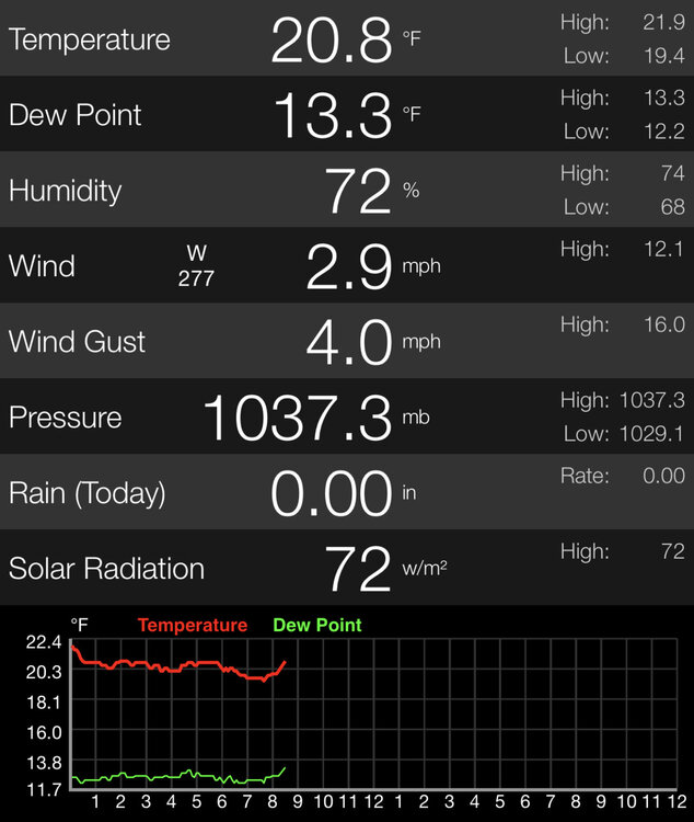
Probably virga to start. Only 0.01" precip by 11pm.
-
NAM 3km looks fine. Everyone N and W of a CHO to Annapolis line looks like 0.25"+ QPF. Pretty intense band at 1-3am.
-
40.2 and the snowpack is struggling.
-
edited!
-
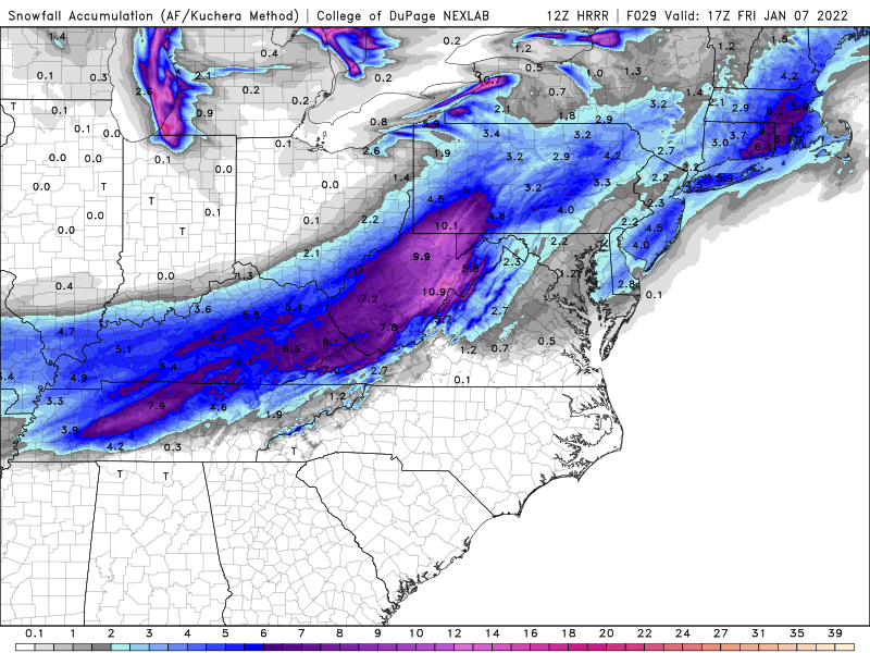
16z HRRR will be the first run that has the entire storm within the 18 hours. The 15z is a minor improvement on the 12z, taking the <0.10" QPF amounts off the table.
-
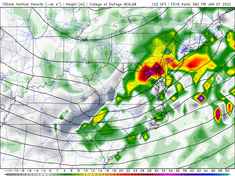
Nice vertical velocities on the GFS
-
12z HRRR has the dead zone near 95. <0.10" QPF in parts of Fairfax and MoCo. This seems like an extreme solution, but puts a lower bound on the event.
-
Down to 3.5" here on the ground. Undisturbed areas look fine still, but lots of green around footsteps and under trees. Interesting temperature trace last night in parts of our area. My brother's station west of Frederick went from 27 to 45 in less than an hour when the inversion broke. Meanwhile I just bounced between 37 and 40 all night.
-
NAM 3km is 0.3-0.4” for many of us, mostly within 4 hours.
-
That is a map of wind speed. Deformation aloft indicates rising motion. That's what we want.
-
The snow on the trees 48 hours after the storm is amazing.
-
Euro ~0.21" for DCA.
-
Sounds good, everyone posted snow maps and not QPF.