Mr. Kevin
-
Posts
418 -
Joined
-
Last visited
Content Type
Profiles
Blogs
Forums
American Weather
Media Demo
Store
Gallery
Everything posted by Mr. Kevin
-
Griteater, I go to dacula mjo to see different rmm projections of mjo from various models. Have u been there? It has (bc) ecmwf , and gefs among others.
-
-
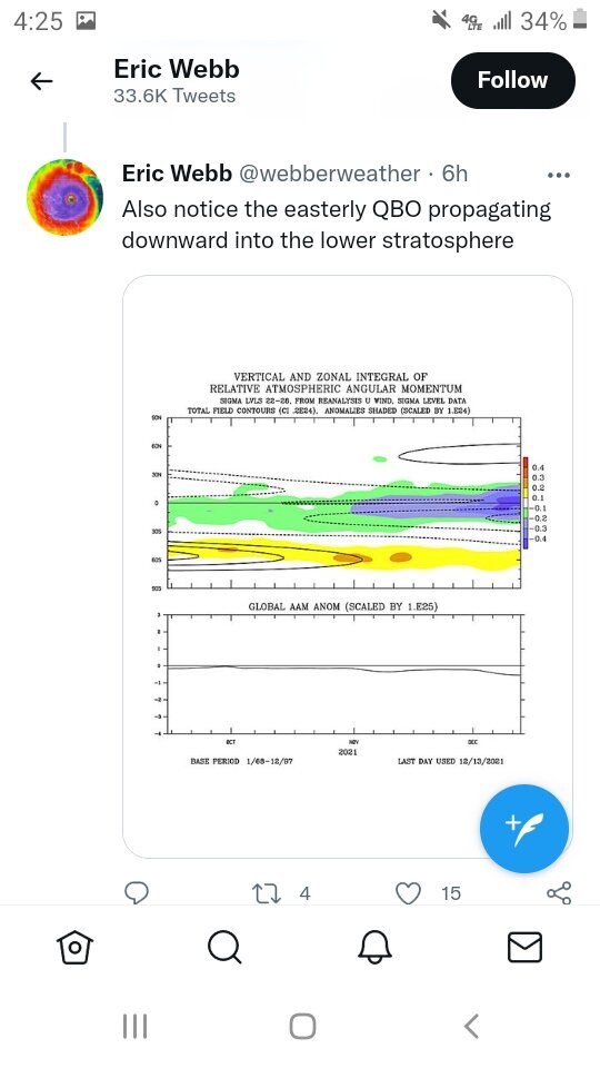
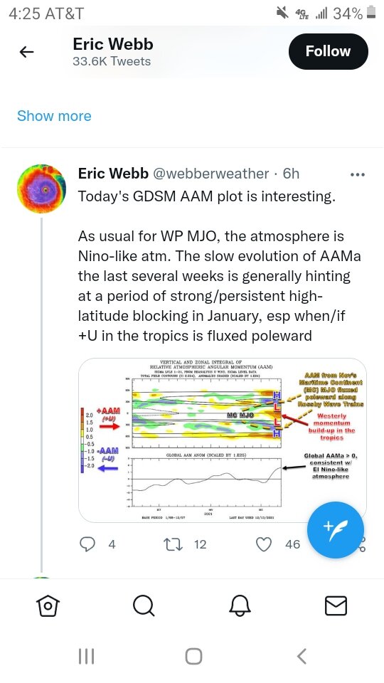
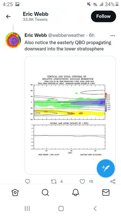
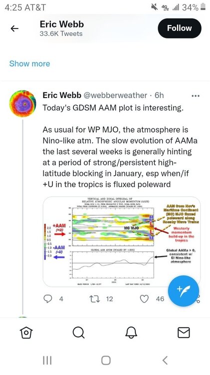
Webberweather made a few good tweets earlier today on Twitter.
-
I have a question. Do you think if we get that Greenland block that's more central to west based and mjo propagation, will we get into a colder regime east of the rockies?
-
I do wonder if the looping of the mjo is from the tropical cyclones in the Pacific. Until something changes, the mjo progression will be key whether we get any sustained cold down here because the pna is hurting us bad and alot of places actually. Alutian ridge isnt helping our cause also. If we get a true west based -nao in the future and dont get cold, we know we are fooked lol
-
Allan Huffman mentioned patience is required lol. 7-1 would perhaps get things shaken up somewhat. Still not cold for sure as of yet. Also, the niña is not even close to -1.1. I have been following the sst anomalies on tropicaltidbits for region 3.4 and it has averaged -.85 for many weeks, so not sure how the cpc calculates that number lol. To my untrained eye it looks like it has been east based for many weeks. Of course I'm no meteorologist lol.
-
Everyone should check out griteaters post on Twitter. Very good read for sure. Its 15 different parts I believe
-
Carver, allan huffman made a good tweet earlier about the eps shifting the nao. Imo, it would have to shift pretty far west to do us much good,because an east based wont cut it in the east, especially with the pna being negative.
-
We definitely would need a few shifts to get us where we want to be moving forward Carver. No doubt about that, even for a week or two of cold air. Get us a west based -nao, then we would be ok then I believe
-
If the -qbo is legit, it should help the mjo propagation into colder phases, which kinda makes sense and either Webber or griteater mentioned that as a potential
-
Definitely want to see a west based nao or its going to be difficult in our area with the alutian ridge too far west. Hopefully we can get there
-
I was actually. It dont usually snow alot with temperature in the teens here. We can go many years without even getting temps in the teens in my local area lol
-
We just want cold enough for winter precipitation here. Last February was an anomaly for sure.
-
Until the euro gets on board, its skeptical for me to believe. I like all the models to indicate something like that but I understand its exciting to see
-
I have never liked the cmc because it overhypes cold and precipitation. It's better than it used to be but still not that good imo.
-
I dont take anything for granted lol. It would be nice to see a cold enough pattern for some winter precipitation here regardless how it can happen or develops
-
I'm referring to the mjo charts from the cfs lol
-
Are those charts at all accurate?
-
I'm kinda suprised the models have adjusted to a colder regime just based on mjo progression unless it's still early. Sorry. Meant to say suprised they haven't adjusted lol.
-
Grit believes the mjo orbits across 7-2, which would imo give us a glimmer of hope moving forward. If we could develop a SSW event, it could allow real cold air to come down but like always they are real tricky
-
I'm just trying to be optimistic since its winter and perhaps we will have a few opportunities at some point even though it is laniña and all niñas aren't the same
-
You may want to read griteaters post and webberweather on Twitter. Our only chance looks to come from the mjo. I feel and icestorm brewing with a -pna,but just my little bit of knowledge I have lol. Do we want a slow track through the phases of mjo for our best chance?
-
Nothing in comparison to what they saw in my area in ne Arkansas and especially in ky. Possibly the longest track tornado ever. 250 miles is impressive
-
I feel a west based -nao is better than east based so I believe that's what we want
-
Hi Jeff. I'm hoping it can. I will take icestorm sleetstorm any winterstorm over tornadoes, which were terrible last night. Hopefully the pattern will adjust to colder and stormier eventually