MarkO
-
Posts
3,397 -
Joined
-
Last visited
Content Type
Profiles
Blogs
Forums
American Weather
Media Demo
Store
Gallery
Everything posted by MarkO
-

"Don’t do it" 2026 Blizzard obs, updates and pictures.
MarkO replied to Ginx snewx's topic in New England
My daughter is down in the Narragansett Pier, and based on radar returns, they've been under some heavy echoes for many, many hours, just pounding snow. I asked her how much, but she said I can't see out of any of the windows, lol. I asked if she coudl hear the wind, she said the house is shaking. It's a little one story ranch. They lost power a little over an hour ago. At least she charged her phone/laptop last night and cranked the heat up. They're most likely getting over 24" before all is done. I've only gotten maybe 6-8" and it's looking like subsidence in my future. Lots of drifts here though, decent wind. Temp in the mid 20's but dropping to 23 now. -
"Don’t do it" 2026 Blizzard obs, updates and pictures.
MarkO replied to Ginx snewx's topic in New England
Woke up around 4:30 and just got caught up here. Nice change in attitude. Only about 3 or 4" new here in Lowell, but we started with about a foot already on the ground. Hoping some of those heavy returns can make it into the Merrimack Valley. Congrats to those to my south beginning to meet blizzard criteria. -
I feel like it's my birthday and I'm going to Red Lobster, maybe Mr. Happy's for a lap dance.
-
Just noticed this post now. I've had a cabin in Thornton for 15 years now. I love it up there. Not ideal for huge snow because it gets shadowed, but still averages in the upper 80-90". I chose my location based on proximity to my house in Lowell. I wanted a place I could get far enough north but within 90 minutes. You pay the NH real estate taxes which suck, but I suck it up for convenience. I also do a decent amount of skiing, so it's almost perfectly situated from many choices. I can get to WV, Loon, Cannon, Tenney within 30 mintes, and about 50 minutes to BW, not to mention our own little hill Campton Mountain less than a mile away where I taught my kids to ski. So it's also convenient to plenty of hikes. I also pay extra to be in a community with amenities like a rec center with pool, pond, gym etc.. Not for everyone, but it fit my family well. Let me know if you need any add'l info or to put you in touch with a real estate agent?
-
Just got back from Japan last night. It was part of a Japan/Taiwan vacation, but we squeezed in a couple days at Shiga Kogen. It's on the Ikon, so my lift tickets were free, but cost $57/day for my son (adult window price). We essentially had the entire mountain to ourselves skiing weekdays. The lifts and hotels are a bit dated, but you can't beat the price. $200/night for a hotel room on the mountain that included a full buffet breakfast and a 7 course dinner. We stayed at a traditional Japanee lodge, so we slept on futons on the floor. They had a nice natural fed onsen in the lodge which was nice to soak in after a day in the deep pow. It was an overall awesome experience, and we'll probably go back next year. The only thing that sucks is the 12 hours of a flight, but when you add it all up, it's a better deal than skiing out west and a waaaaaay better experience. As for the snow. Not sure if they average as much snow as they've been getting this winter, but they got dumped! If you're not used to skiing deep, deep pow, Japan might not be for you. They do a good job grooming, but if you duck into the woods, or seek the higher elevations, do not stop! But if you do, do not get out of your skis! The pow is so dry and light you will sink down to your thighs.
-
Ice Ice Baby December 28-29 Storm Discussion
MarkO replied to Baroclinic Zone's topic in New England
31.6 and rising.Good luck to the folks north of me. <<edit> lost power up north. -
Wounded Duck Strikes Back: Dec 26 & 27th Winter Storm Obs
MarkO replied to WxWatcher007's topic in New England
NWS map shows about 3" for me here in Lowell, but my offiial measurement this AM was 2.6". -
about 1.75" of dense pack.
-
Night and day. Just got back to Lowell from up north. Left there and it was 18F and just started snowing. Got to Lowell and it was milky sun and 40F. Expecting 6-8" up there but the raiin might wash away the 2" of snow we got remaining here in Lowell. It just seems like this is going to be a NNE winter. At least the first half. Heading out to Steamboat for a week. Barely enough snow to ski out there. They've only gotten 35" since they've opened and ain't getting anything over the next week. Sucks.
-
Rub it in, haha
-
Another inch fell last night, so a total of about 3" here in Lowell. What remains on the ground is only about 2", but that first inch is probably half water. I know Ray think's it's going to disappear, and the top inch of fluff certainly will, but i's not going to in areas to the north and west of me. We just both got screwed being less than 10 miles from the goods and you can sense it in the posts. I remember making a post years ago about drawing a map of New England of where a snow "pack" usually builds. I don't believe Lowell nor Methuen is in that area, but you go just west side of Nashua (10 miles to my NW) and I believe you're in the southeast edge of it. It kinds goes where snowmobile trails exist. Maybe I've gotten a little soft/less worrysome about these shitty events because I spend about 1/2 the time at my cabin, and this time of year, it's all about pack building. We might get an inland cutter that drops 2" of rain, but a good majority of that ends up building the pack. Sure, sometimes there's bare ground on Christmas, but that might be 10% of the time. Go 10 miles to my N up there and you're in elevated land and it's probably closer to 1% of the time. That post about storm anxiety made me laugh though. I never really get true anxiety, but a lot of people do including my wife, holy fu@#, I just get angry, lol. They may have been referring to the "milk and eggs" people, which I'm certain exist, but I think anyone posting here has gone through met anxiety. I could name names, but I think we all know who we are, lol. I certainly did/do, and that probably has a lot to do why I built my cabin 100 miles north of here. My friends and fam are like "We're so glad you built this place for us to come and enjoy" and I just chuckle inside to myself. I packed my shit and was ready to leave last night around 8 to get some runs in, but I have a job to do around here, and I hope the snow does melt a little because it actually involves a drone and the top inch melting away.
-
RI is the tropics. Still probably mowing their lawns.
-
I feel your pain, but it looks like winter out there. There's nothing really wet at all. I mean, yeah, it's light freezing rain, but it's freezing to everything, and I don't think it's going anywhere anytime soon. There's still more qpf on the table. Holding steady at 31.5F
-
Just noticed rain drops on the window. Freezing ran/sleet 30.7F in Lowell. Looks like we got between 1.5 and 2" before hte flip.
-
I hope for you it doesn't, but it seems to be marching north. I just hope it remains below freezing at the surface. OF course I'm still holding hope it could bomb out but this system just lacks the dynamics.
-
Yup, just looked out the window and realized it's a mix of sleet and snow, almost all sleet now. 30.0/29.3. I wonder if this is going to turn into a mess?
-
Yup, you can see the battlezone marching NNW on radar. It's about 10-15 miles south of where I expected it to be. Temp has crept up almost 2 deg since I bottomed out at 27.9 around 11AM. That r/s line should continue NNW for a few more hours before it might collapse back towards 128. It's been mainly light snow 1.5" OTG 29.7/28.7.
-
Weren't you sleet just an hour ago?
-
1/2 mi vis. About 1/2" OTG 28.2/26.7. The latest HRRR would be an epic overproducing bust for the 495/MV area
-
Antecedent cold should help keep this snow until mid afternoon. Hoping for a positive bust. Dusting, 27.1/21
-
First Winter Storm to kickoff 2025-26 Winter season
MarkO replied to Baroclinic Zone's topic in New England
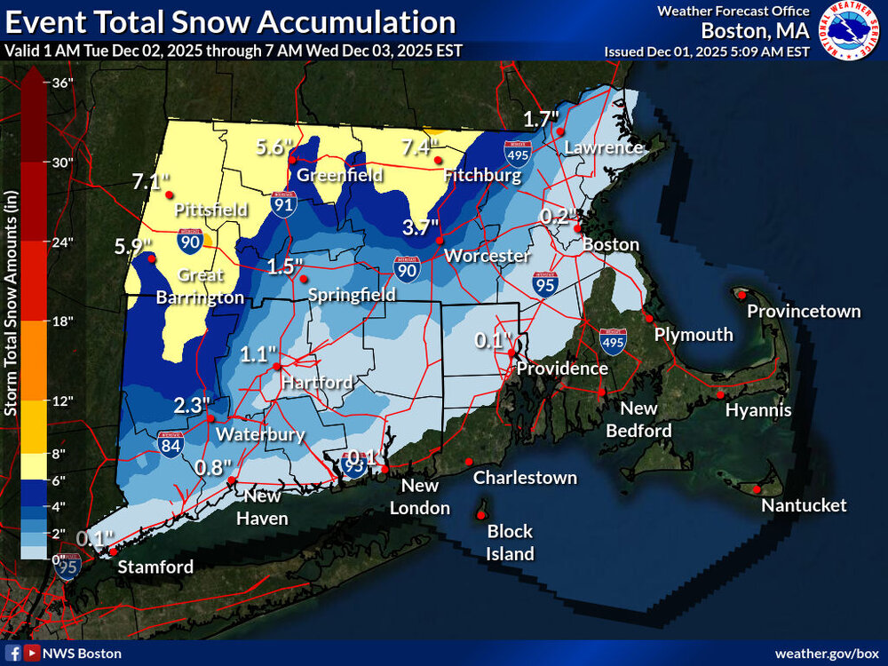
Woke up hoping for some model guidance resolution. I first checked the NAM with 2" dang it, GFS still showing 10. Talk about a now cast. NWS split the difference. Still holding out this thing bombs this afternoon. I'm good with whatever happens. Looking to ski this weekend, but I also got a lot of surveying fieldwork, but it aint gonna get done today. -
First Winter Storm to kickoff 2025-26 Winter season
MarkO replied to Baroclinic Zone's topic in New England
Us folks on the 495 belt need as much help as we can get. It's down to 32F here in Lowell, and the Davis is reporting 22 at the cabin. Sounds kinda nuts, but I think the action is better here in Lowell. A dry 8" of snow up there is kinda meh, but if we can out an over producer in the 495 area, it will be a sloppy mess with power outages. -
First Winter Storm to kickoff 2025-26 Winter season
MarkO replied to Baroclinic Zone's topic in New England
Ahhh, fk'in toaster bath for me. The 1800 NAM has got the dual lows that the Euro had. I'll be on the wet side of this one. At best, I forsee a Halloween 2011 redux. Heavy wet snow that accumulates to 3". -
First Winter Storm to kickoff 2025-26 Winter season
MarkO replied to Baroclinic Zone's topic in New England
Wachusett should be all snow, but it's still going to be a wet snow. -
First Winter Storm to kickoff 2025-26 Winter season
MarkO replied to Baroclinic Zone's topic in New England
NWS map going with warmer solution. If it doesn't bomb, it's 2" of slop for me.