

mattie g
-
Posts
13,911 -
Joined
-
Last visited
Content Type
Profiles
Blogs
Forums
American Weather
Media Demo
Store
Gallery
Posts posted by mattie g
-
-
1 hour ago, North Balti Zen said:
It wouldn't be as bad as it is in the long range thread if people would stop trolling. Control maps from 1100 hours out of context etc. Drive by comments with literally nothing to add other than to complain. the ratio of shit posts to quality posts is way out of whack. I would almost lock that thread so that only about six posters could post in it. Or maybe see if randy will allow the mods to nuke the trolling shit straight to hell, that would help too.
It also didn't help that mt psu made everyone care about his backyard for early snowfall and ratcheted up the anxiety level.
What I find the most annoying is the truly disingenuous posts from experienced/long-time posters. Whether those are trolling posts, ones simply made to get a response, or even ones made out of ignorance, they irritate me to no end because they end up pushing a bunch of weenies to cry in their Cheerios and shit up the thread.
-
 2
2
-
 1
1
-
-
Nicely researched. Good luck with the forecast!
-
1
-
-
2 hours ago, stormy said:
The GFS has developed the same bad trait as the Euro, but of course, what do we expect beyond 300 hrs..
But how much precip are we going to get, and are the hillsides of the Shenandoah still going to spontaneously combust by the end of the winter?
-
 3
3
-
-
1 hour ago, WxUSAF said:
34


Worst site ever.
-
One really good thing about yesterday's event was that it was a nice day-long soaker with some heavier rain thrown in for good measure.
Looks like ~2.3" in Burke.
-
23 minutes ago, aldie 22 said:
anyone still planning to mow this year?
Need to clean up more leaves, so I'll probably have my last mow next weekend. Need to edge, as well, to clean up the look for the winter!
-
1
-
-
9 hours ago, Roger Smith said:
I looked back at previous snowfall contests, first point being, this is actually the tenth one, they date back to winter 2014-15.
In winter 2013-14 there was a contest to predict how often winter storm warnings would be issued. But no snowfall contest in evidence in thread titles.
The history of contest results is interesting, in all but three winters, just about all forecasts were too high. Over nine contests, about 85% of forecasts were too high in total and probably about 75 to 80 per cent were too high for specific locations. It would be even worse except for an opposite tendency in 2015-16. I show the ten-year average values to see how they do in 2023-24. I continue to think that this winter will be a good one, so I won't transfer those to my forecast (may regret it) ...
Winter _____ BWI _ DCA _ IAD _ RIC _____ winner (total error) ______ notes
2022-23 ___ 0.2 __ 0.4 __ 0.4 __ 0.0 _____ Little Village Wx +13.0 __ all fcsts too high in total snow
2021-22 ___14.4 __13.2 __15.8 __ 4.7 _____ I Used to hate Cold (4.6) __ about 2/3 fcsts too high, just a few were too low
2020-21 ___10.9 __ 5.4 __ 12.0 __ 7.0 _____NorthArlington101 (3.1) __ about 3/4 fcsts too high at all locations
2019-20 ____1.8 ___ 0.6 __ 2.9 __ 1.5 ______ Prestige Worldwide (3.6) __ all fcsts too high in total snowfall
2018-19 ___ 21.1 __16.9 __21.6 _ 13.9 _____ Olafminesaw (7.9) won tiebreaker with Stormpc also 7.9, RodneyS close at 8.2
___________________________________________ about 3/4 of all forecasts were too high despite a fairly good outcome
2017-18 ____15.4 __ 7.8 _ 11.9 __ 12.4 _____ Olafminesaw (6.8) ____ almost all forecasts were too high in total snow
2016-17 ____ 3.0 __ 3.4 __ 7.3 ___ 7.1 ______ stormpc (16.1) ____ almost all forecasts were too high in total snow
2015-16 ____35.1 __ 22.2 __ 34.3 __15.1 ____ shadowzone (7.0) ___ forecasts scattered around result but 2/3 too low (almost all snow was on Jan 23)
2014-15 ____ 28.7 __18.3 __36.9 __12.8 ____ nwbaltimorewx (3.4) ____ forecasts scattered around result
_____________________________averages ___ 14.5 __ 9.8 __ 15.8 __ 8.3 ____ average winning error total (6.2") _ 1.5 to 1.6 per location
past seven __ 9.5 __ 6.9 __ 10.3 __ 6.7
===============
From above it can be seen best forecast all-time was 3.1" total error (NorthArlington101 2019-20). Nwbaltimorewx was close at 3.4" in 2014-15.
Keywords: optimism, climatology denial, occasional surprise endings
Claiming that we have collective climatology denial is actually pretty harsh. I don't think anyone here denies that our snow climo isn't great, but unless you're one of the Debs on this forum (you know who you are), what fun is it to go into a season picking low snow numbers? It's more about optimism and the hope that we can break our snow duck.
-
4 hours ago, brooklynwx99 said:
looks like our next potential shot at something as this vort rounds the trough. GEFS picks up on it well this time
Precip to our SE off the coast. Winter cancel.
-
2
-
 1
1
-
-
That line…
-
1
-
1
-
-
4 hours ago, GATECH said:
Just booked my winter insurance trip to Canaan Valley, last weekend in January…
We’re going with a few other families later in Christmas week. Maybe a little early, but hoping to max out while we’re there.
Should be ideal timing for you, though. Good luck!
-
1
-
-
6 minutes ago, Terpeast said:
At least the STJ is there.
But that one week, Terpeast! That ONE WEEK has the heaviest precip offshore!
OH, THE HUMANITY!!!
-
2
-
3
-
-
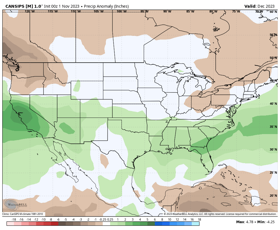
1 hour ago, stormy said:
The latest CANSIPS paints that perfectly for December.
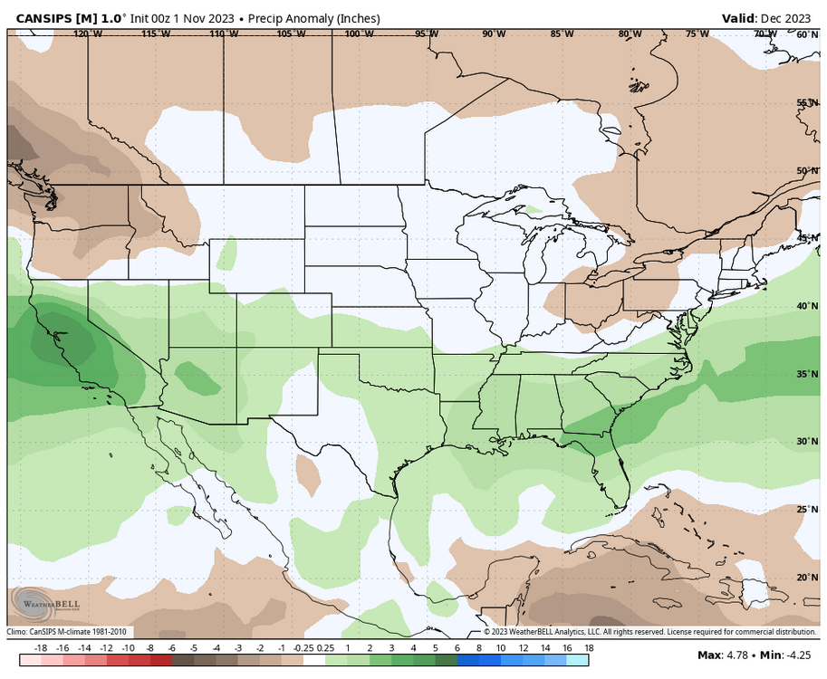
Soooo...a pretty canonical Nino look with us on the northern edge of the positive monthly precip anomalies?
-
1 hour ago, PrinceFrederickWx said:
I want a dollar every time I hear about "that look" and the "El NIno flex"
And I want to gouge my eyes out every time I read a post from a person who can't help but be f*cking doom and gloom.
"Ooooh...look, the positive precip anomalies for one week in the middle of December are too far south!"
"UGH! That look is soooooooo Nina!"
"It's so dry. It's going to remain dry for the rest of the winter!"
F*ck's sake...
-
2
-
4
-
-
Radar is filling in with the steady stuff just starting to fall.

-
1
-
-
2 hours ago, WxUSAF said:
I’m declaring a SEVERE LEAF DROP WARNING for the entire region for the next 48 hours.
There are barely any leaves on the trees at this point IMBY (actually my neighbors' backyards)! It'll be good to have the stragglers gone though.
Really raw morning. Bus stop this afternoon should be fun!

-
49 minutes ago, WxUSAF said:
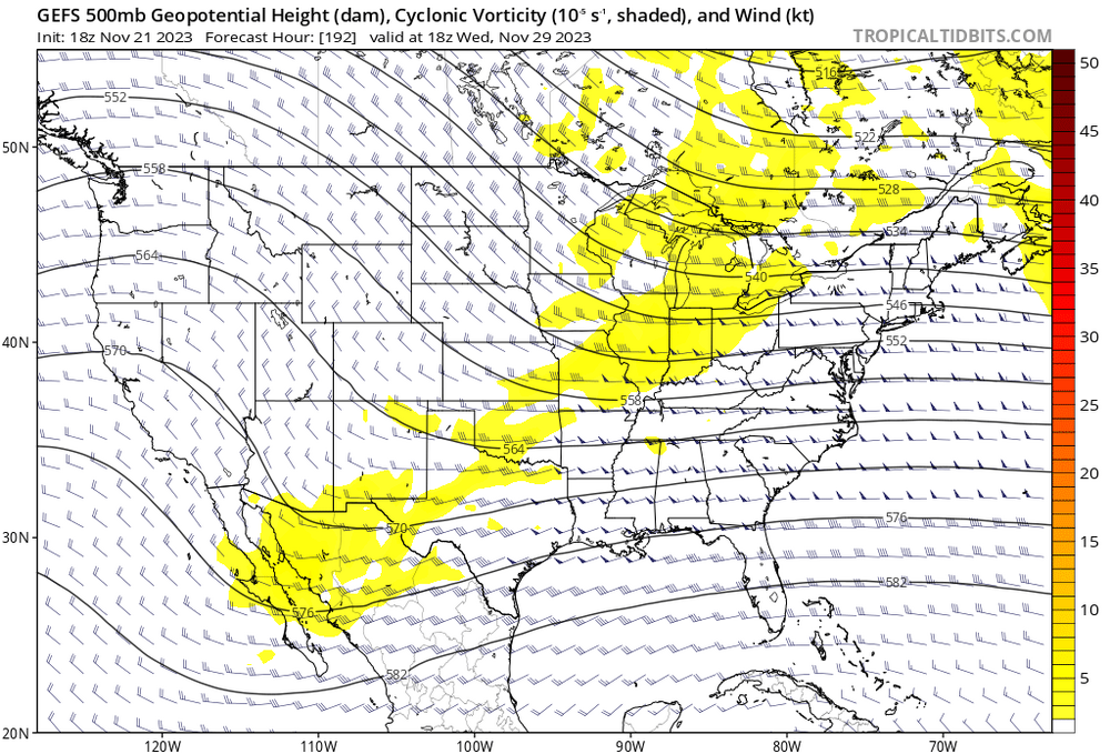
GGEM and Euro both have a pretty tasty setup around Saturday/Sunday. Neither really come together, but the players are there with a transient 50/50, fresh high coming in on top of low forming in the Plains and riding the thermal boundary eastward. Both models have another northern stream shortwave come in and mix everything up.
This is another thing I've ben watching - how the timing of waves plays with the injection of cold air. I'd sign on the dotted line right now if we could get a winter in which we have waves riding from the southwest along the thermal boundary and throwing moisture up and over fresh, cold airmasses. Easy 3-6"/4-8" without worrying about the mids torching as warm air screams in aloft from the south.
-
3
-
-
7 minutes ago, CAPE said:
Extended products depict a continuation of Aleutian low/AK ridge well into December. Good sign as we move forward into early winter.
Get the general pattern set up now and we wait and watch.
-
4 minutes ago, WxUSAF said:
Webb responded to his tweet with something basically like “yup, called that December torch!” I wanna be like “Bra, did you even click the link??”
I see blues and reds in wat I think are good places, but I don't *really* know what I'm looking at (but at least I looked).
-
2 hours ago, aldie 22 said:
Wonder how much has changed in the last 13 years
") found this work done by Ender on here back in 2010...i guess you can file this in the PSU first inch category of analysis.
found this work done by Ender on here back in 2010...i guess you can file this in the PSU first inch category of analysis.
After reading mention of the "mid-Atlantic December 5th rule" I decided to take a look at historical DCA first .5" or greater snowfall dates and the implications for the ensuing winter. Here's what I found:
If the first such measurement was in the month of November (11 cases) then the winter averaged 17.1" with 13.7" falling after the first Nov snowfall.
If the first .5" or greater fell between 12/1 and 12/15 (17 cases) there Winter averaged 21.3" with 17.9" falling after the first event.
If the first .5" was between 12/16 and 12/31 (13 years) then Winter averaged 19.2" with 15.4" falling after that first snowfall.
If the first .5" was in the month of January (21 years) then the entire winter only pulled 12.1" with another 9.5" falling after the first snowfall.
Looking at the results from the angle of first snowfall depth was somewhat more interesting.
If the first snowfall was >4" then the season as a whole averaged 28.3" with 20.1" falling after the first storm. A total of 16 years met this criteria.
If the first snow was between 2" and 3.9" then the winter's total averaged at 11.5" with 8.75" falling after the first event.
In the 20 years where the first storm was between 1" and 1.9" the winter averaged 15.2" with 13.8" falling after that first snowfall.
A total of nine winters saw a first .5" or greater snowfall of between .5" and .9" and those winters only averaged 12.3" for the entire winter.
NOTE: I only considered a snowfall the "first snowfall" if the measurement was >=.5". So if .1" fell on 11/17 and .2" fell on 11/22 and .9" fell on 12/3 then as far as this "research" is concerned the first snowfall was the .9" event on 12/3.
The average of the entire data set (1945 - 2010) was 16.5".
Damn man…that’s your first meaningful contribution to this board in years. Nice work!
-
1
-
2
-
-
2 hours ago, WxUSAF said:
Nino!!
B…b…but Nina lag!
-
7 minutes ago, MN Transplant said:
Totally cliche, but the models are juicing up as we get towards the event tomorrow. 1.5”-2.5” widespread.

-
4
-
-
2 hours ago, CAPE said:
Snippet from Mount Holly AFD wrt Thanksgiving day-
However, some models/ensemble members, most notably the 00Z GFS, depict another closed mid level low developing, resulting in surface cyclogenesis, with another round of precipitation possible on Thursday as the low slides off shore over Delmarva. For now, I`ve stayed close to a consensus blend that doesn`t include the GFS as I can`t recall another event with an evolution like this, and so far this seems to be an outlier solution. Therefore, the forecast keeps Thanksgiving dry with temperatures slightly below normal.
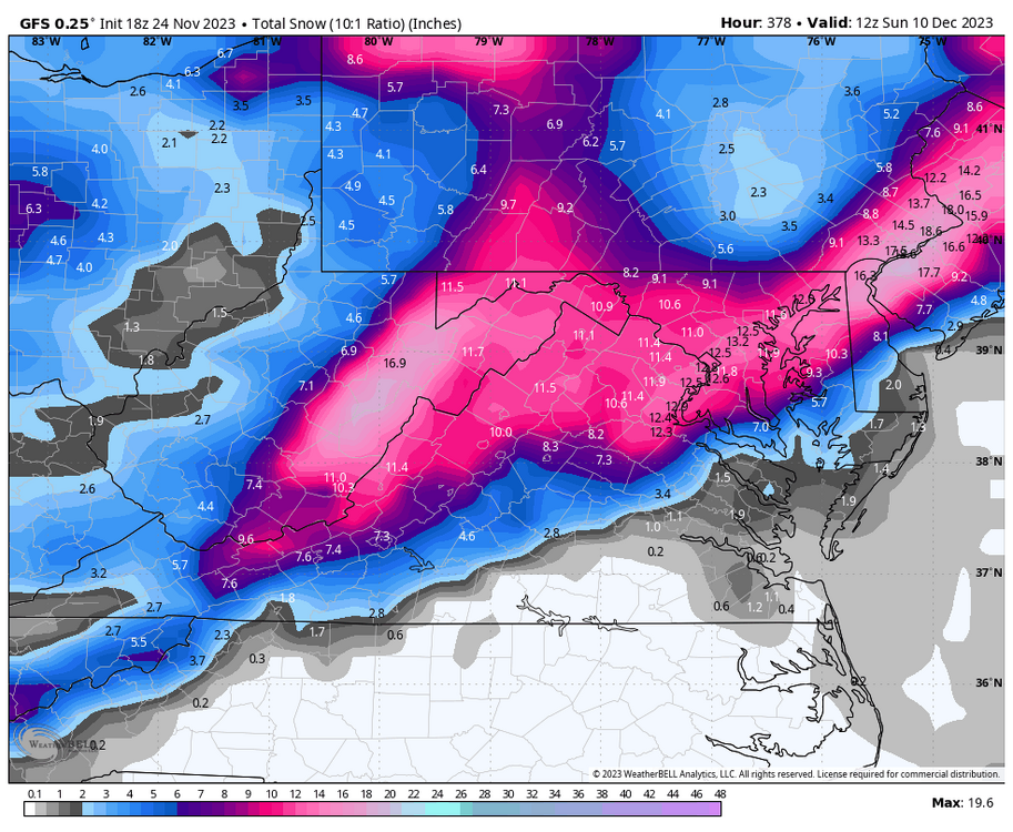
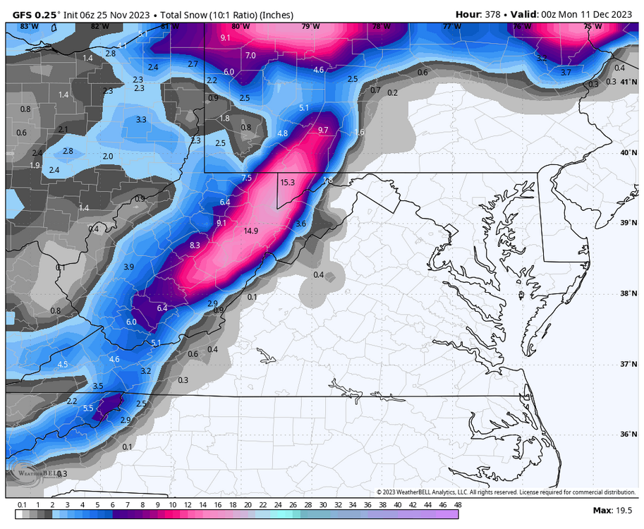
Interesting that they’re essentially tossing the GFS’s idea from the last couple runs of a system forming down south and riding up the boundary to firehose us on Thanksgiving.
Curious to see if the GFS stays its course over the next few runs or corrects back to a solution similar to the one we’ve been seeing for some time.
-
1
-
-
23 minutes ago, Terpeast said:
We're already in mid-winter form.
Canceling winter before it even starts.
In a -PDO/+ENSO battle like this season, there's going to be a lot more of this.
At least it won't be boring like last winter.
Just look at the models... STJ is becoming more and more active.
This is what I'm focusing on. I love seeing the Nino start to flex, so from there we can have a little more confidence in things progressing in a fashion that many of the smart folk are foreseeing.
It's November, so it's not supposed to snow IMBY, nor in the backyards of most of us on here. We need Manchester to get an inch in the next few weeks, but otherwise we just keep an eye on the progression of the atmospheric response to the Nino and hope for the best!
-
4
-
-
This board can seriously f*cking suck sometimes.
-
6
-
2
-
8
-


November Banter 2023
in Mid Atlantic
Posted
Dulles's normals today are 52 and 33 and it never averages less than 42 for a high and 25 for a low. Folks need to readjust their expectations.