

Kmlwx
-
Posts
13,616 -
Joined
-
Last visited
Content Type
Profiles
Blogs
Forums
American Weather
Media Demo
Store
Gallery
Everything posted by Kmlwx
-
We're all still waiting for our next region-wide event, though. We're starting to get into the time of year when pulse severe dominates generally. There can be exceptions, of course...but one reason I really like April to June is that you can generally get better shear and such. September can be really good too if things fall right. I know I've said this 100+ times - but I REALLY think (even if only anecdotally still) that we had more regionwide squall lines in the 90s and earlier 2000s. Not necessarily derecho-quality events - but just solid lines extending from the M/D line down into VA. Seems we have become a more line segment or lone cells kind of area. I'm sure some of this is just me remembering wrong - and maybe also lower quality radar sources when I was a kid (I relied on the local forecast on TWC).
-
I'm not just saying this - but when I glanced at radar before leaving Colesville to head to my place - I had a feeling there might be a surprise in the works when I saw those lone cells getting going to the west. Had that trajectory/feeling of something that could propagate towards the metros.
-
Looking at the CAMs - I'm not sure the marginal needs to be as far south as it is for tomorrow. I think most of us may even stay high and dry. I can see why there's a marginal for Sunday, though.
-
Good example of how it only takes one or two cells to make or break a day for individual backyards. Big factor is WHERE the cells go. Had the cells stayed over the mountains or cut up into PA before coming into the urbanized areas - would have been called a whiff. But it went through the metro area - so it gets a higher mark simply because of the location. I probably would have gotten a better dose of the storm had I been at my parent's house in Colesville *eyeroll*
-
Pretty good storm *sub severe* here in the Arundel Mills area. Sneaky day!
-
Looks like DCAPE is where we really took a hit versus yesterday. Down AOB 500 today.
-
Mesoanalysis has SBCAPE coming up through 3500 in a large area. Very good DCAPE already too.
-
That's good to hear. I had seen some chatter on Twitter about NCEP declaring it "unstable" and "freezing development"
-
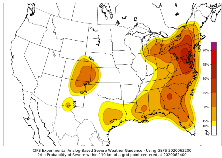
Day 2 on the 0z CIPS guidance. Doubtful the result will match how robust this looks.
-
Seems tomorrow and Tuesday could have some iso instances of severe. Also - I'm late to the party but it looks like the HRRRv4 is no more. It hasn't been sending data from NCEP - I noticed it on the COD site. Does this mean they'll bring back the v3? Or is v3 the operational?
-
I think June 4, 2008 stands out for me because of the situation I was in. I had been sneaking peaks at the SPC site and the forums throughout the day. If my memory is correct, I hightailed it home (I walked through a patch of woods from high school to get home back then) and got to watch the bulk of it from home. Grade school made me miss a lot of good events I think June 29, 2012 takes the cake for me though. Simply watching the reports coming in as it came over the mountains is something I'll never forget. I had friends who were on a boat in the bay texting me and acting like I was downplaying the whole thing. A few days after, a few of them reached out to tell me how right I was and how glad they were that I pretty much forced them back to shore.
-
Thank you! I'll check them out!
-
I was just reviewing 2008 - severe weenies were truly spoiled that year. Not only did we have regular severe... We had MDTs on May 31, and then June 4, 10, 16. That's for moderates in just over half a month. Dang impressive considering we can go years in some cases without a moderate at all. It's tough enough to get decent slight risk days every few days for a good stretch...
-
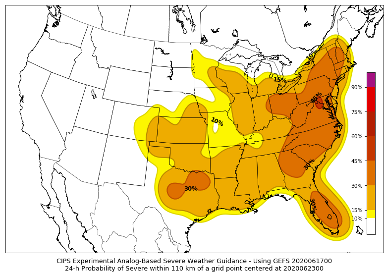
The extended CIPS page has a good signal at hr168 too. This has a been a weird met summer so far...and spring for that matter. Maybe the atmosphere is having COVID hangover like we all are.
-
June 10, 2008 has been showing up in some of the CIPS analogs. Last night's run it's for the 120 hour mark.
-
CIPS is seeing something around hr144.
-
Latest HRRR run has some decent looking storms coming through around 05z.
-
Detroit is not the most common place to get a moderate. I guess I'll be living vicariously through them today.
-
12z CIPS guidance DOES have a bit of an uptick in severe analog risk around the 60hr frame.
-
Speed it up and I might be interested. Meh.
-
Not MBY so who cares
-
Not much to speak of in the Arundel Mills area.
-
Batting .090
-
Good storm with a lot of lightning here in the Hanover/Arundel Mills area. Nothing severe, though.
-
That northern warning looks awfully weak.


