

Kmlwx
-
Posts
13,551 -
Joined
-
Last visited
Content Type
Profiles
Blogs
Forums
American Weather
Media Demo
Store
Gallery
Everything posted by Kmlwx
-
Don't your dare
-
NAM nest parameter space for tomorrow looks great - reflectivity not so much.
-
Whoops...this is what happens when I spend so much time looking at tomorrow.
-
Because we love to predict the prediction (guess what SPC will do) around here - my guess is minimal changes (if any) at the 2am update. Probably the same for the 1300z unless something is very apparent. 18z NAM twins will run in the next hour.
-
WOOF 12z ARW, ARW2, NMM, HRDRPS, RGEM all look great for tomorrow in the SPC enhanced area.
-
Very strongly worded discussion from LWX now as well. .SHORT TERM /THURSDAY THROUGH FRIDAY NIGHT/... Dry weather is expected to continue through early Thursday with temps in the 70s. Another higher risk day is expected Thursday afternoon and into early evening. The front to our north will drop southward through the day Thursday. This boundary coupled with warm and moist air advected into our region due to a southerly flow along with strong shortwave will lead to an enhanced risk for severe weather. CAPE values will increase above 2000 as temperatures and moisture increase during the day Thursday. Shear will be better than today which will lead to an increased risk for a tornadoes Thursday. SPC has upgraded our region to an enhanced risk for severe weather with a 10 percent chance for tornadoes. Thursday could be a very dangerous environment with more widespread threat for severe weather and tornadoes. We will to need monitor the changing weather situation to determine the timing, coverage and risk for Severe WX tomorrow.
-
FWIW - There wasn't really much of a signal on CIPS the last day or two for tomorrow either. Some enhancement but nothing to write home about. I generally like bowling ball closed upper lows better (or a very amplified pattern in general) for tor risk around here. I think the lack of CIPS shows us that our better severe events potentially have a different configuration at some height level. Nonetheless, ingredients are there for a fun day. Not "outbreak" status though.
-
For the heck of it - I took a look at the H5 maps for September 24, 2001 - didn't realize how amplified H5 was for that. Nothing at all like that setup. I think a lot of people like to sleep on September for us. But September might as well be May/June. I think the outlook is about as robust as it is going to get. The most I could see is a non-hatched 15% showing up. I don't think the ingredients are quite there for hatching of EITHER wind or tornado.
-
You know it's real when @andyhb pops into our subforum. Do you think we perform or bust tomorrow? I doubt this goes to even a D1 moderate. It seems like the kind of scenario that is exactly the reason they mad the "enhanced" category. I'll eat my words if I'm wrong. Further, assume they'd wait for 1630z tomorrow to do it. I just don't think the coverage is going to be wide enough - it's already a tiny 10% area to begin with - and no derecho type setup.
-
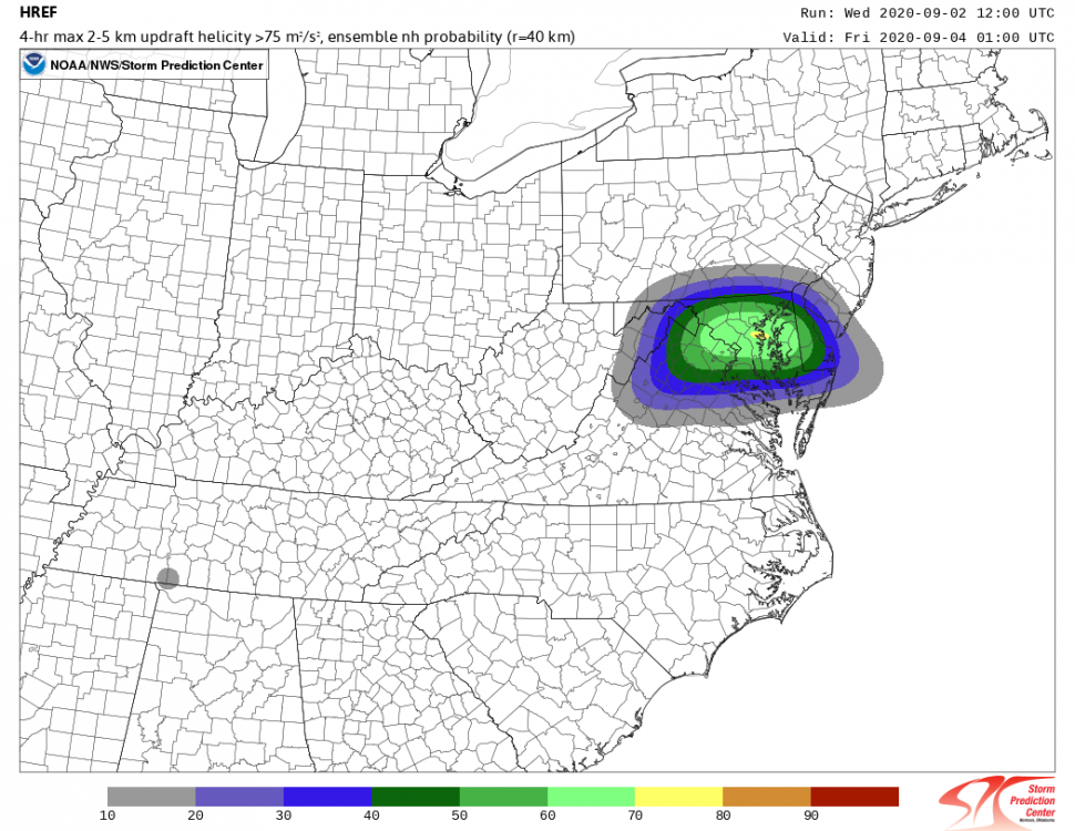
This is from the 12z HREF on the SPC page. Clearly shows the area that SPC is highlighting.
-
It tends to update a few minutes faster than the actual SPC site. Useful for us weenies that hit F5/refresh waiting anxiously for the new updates.
-
Tomorrow. The new D2 is out on the COD Kamala site. Paging @yoda
-
Enhanced wow. 10% D2 tornado with a DC area jackpot and 30% wind. That's impressive for this part of the country.
-
It's always nice when you pop back in here. Miss the 2008/2012 type days. Fall can be really boring other than awesome weather around these parts - be nice if we could get some excitement.
-
Sure sounds like Ian is onboard to me. The new D2 should be an interesting read...assuming they don't do one of those things where they just rephrase the old discussion and make no changes to the maps.
-
Interesting the SPC discussions have been more often than not referencing "CAT 2/SLGT" type language recently. Wonder if a relabeling is coming in the next few years.
-
Yep - looks like slight for TOR and Wind.
-
15z HRRR has backed down a bit. Shows one big cell in the Baltimore metro area this evening but nothing for everyone else.
-
And of course - knowing our area we will find a way to blank on both today AND tomorrow. Latest HRRR still looks good for storms this PM but with pretty garden variety intensity.
-
To be honest - the parameters (and I know these don't necessarily guarantee anything) for today and tomorrow look about as good as any event we've seen this year so far. If we can get decently unstable tomorrow I could see it being a 10% tor day - especially given that text from SPC in the day 2. Very doubtful they'd introduce that until D1 though. I think a lot of areas will see storms this PM - the question is how severe they will be.
-
There are some PDS TOR soundings showing up on the NAM nest for both today and tomorrow The NAM nest reflectivity looks great for DC tomorrow - less so for @mappy. Taking the NAM nest at face value would put the bigger emphasis on tomorrow.
-
How about the 2007 Sleetfest. That one was amazing.
-
Noteworthy parts of SPC Areas of precip and cloud cover will render a rather patchy or streaky planar buoyancy field today. Still, with rich moisture over most of the warm sector, areas of sustained diurnal heating should offset modest mid/upper lapse rates enough for areas of 500-1500 J/kg peak MLCAPE over higher terrain, and 2000-3000 J/kg over parts of the Mid-South and east of the Blue Ridge in VA. Low-level and deep-layer shear generally should increase northward into areas of weaker overall instability, but may favor supercell potential as far south as central/southern VA. Effective SRH of 150-300 J/kg may develop intermittently from there through northern NY, especially near and east of the prefrontal trough where surface flow is most backed. Some part of that corridor may require an upgrade to unconditional probabilities once mesoscale placement, coverage, and timing/forcing uncertainties are better resolved
-
12z HRRR argues for a period of sunshine around DC for a little while at least.
-
And going back to the discussion we've all been having the last few days - a slight is so common around here there's little bust potential. Still pretty dreary here...so maybe that plays a role.


