

ORH_wxman
-
Posts
93,092 -
Joined
-
Last visited
Content Type
Profiles
Blogs
Forums
American Weather
Media Demo
Store
Gallery
Everything posted by ORH_wxman
-
Yeah sounds right.
-
On pivotal it doesn’t and still has 6-7” for your backyard. I think it’s a bit aggressive but I like seeing those numbers as it gives more confidence we won’t just get 2” before the flip.
-
It’s all about the rates. It’s gonna snow for quite awhile. Prob a solid 7-9 hours before it flips…perhaps even a bit longer NOP. Most of the short term guidance really tries to ramp it up for a time between about 10pm and 3am. So yeah, if we can go like 1/2-3/4” per hour and maybe mix in a couple hours of 1”/hr during the peak 6 hour period, then you’ve got your 4-6” easy. RAP/HRRR try to go 7-8” even in spots…I think I’m selling those amounts but 4-6 is def doable.
-
RAP and HRRR are both really hammering the pike region with good WAA banding tonight. Both have 6”+ for ORH over to BOS.
-
28F at Logan at 1pm. Don’t think his 37F is looking very good.
-
Yes they did. Still some decent westward spread though.
-
Or we could look at like half a dozen other KU storms in the past decade that did not lose it at all…and then count a bunch of storms that were lost at day 5 and never came back.
-
He thinks he’s getting 70mph winds with a third of an inch of radial ice.
-
Like I said to Tip yesterday…Ensembles until 12z tomorrow. Otherwise you just end up flip flopping with each OP run that comes out.
-
Yep. There’s prob some sleet contamination too. He’s outdoing even his usual obsessed weenie self. I’ve honestly been through like 10-15 icing events in ORH more interesting than this one.
-
You realize that isn’t radial ice, right? If you got half of what was shown, it would be a nuisance event.
-
Yeah there is definitely a cluster of later phasers. It could go either way…we’re still 5 days out. This isn’t like it’s 2-3 days out.
-
Yeah colder than 06z by a tick. I’ve notice the earlier parts of the transition in ptype have trended colder the last couple runs even if the ending has been similar…wonder if we’ll see tomorrow afternoon/early evening trend colder NW of the CF as it gets inside of 24h. The mesolow early on has looked a little more defined.
-
3k tries to wash out the sleet line for a couple hours. Reminds me of 12/16/07. Won’t be as much snow as that one but something to watch
-
I think people need to also understand the difference between flat ice and radial ice accretion. The flat ice is a newer way to measure it but it’s not the same as radial…it’s less. Radial ice was the old way. A half inch of radial ice is way more impactful than a half inch of flat ice….flat ice is roughly half the impact. (About a half inch of flat ice is the same as about a quarter inch of radial ice)
-
Agree that is a better chance for some impactful ice. Ineedweenies just doesn’t remotely get enough QPF as ice.
-
Doubtful on big ZR and big damage. Not enough QPF falls as ZR
-
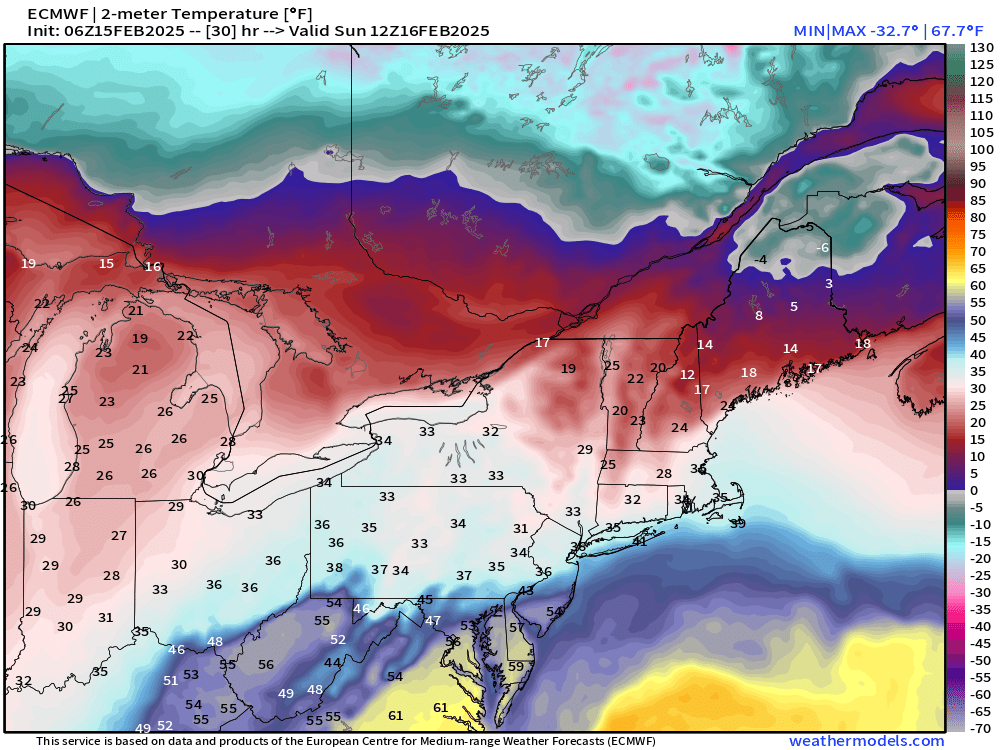
It’s somewhat close looking at euro. Here is 12z tomorrow
-
What storm would’ve given over 6” here? Had exactly 6” in the 1/19-1/20 event. Clipper in Dec gave 6”+ to ORH but not where I am. I was a bit too far east.
-
It’s already a glacier. Add 3-6” with sleet on top, a little ZR, some cold rain and a quick refreeze…piles could become pretty impressive despite the fact we haven’t had an event over 6” all season.
-
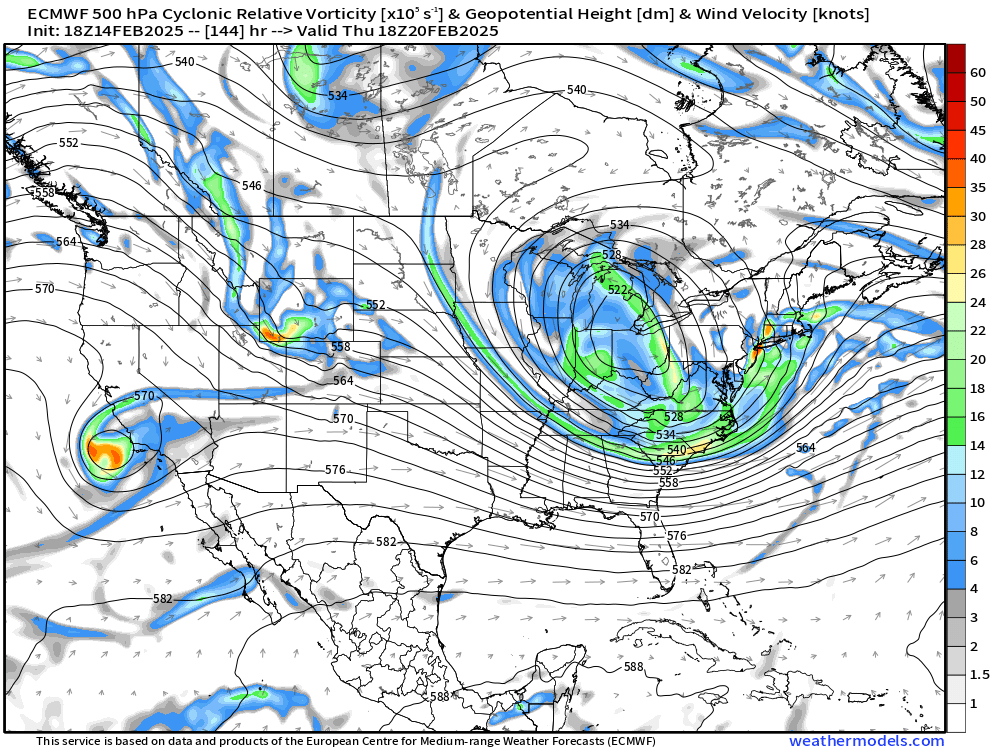
Look at h5 at 144. That would probably be going on for a while
-
Heavy rain at 33 is still going to run off. If you can’t freeze it or absorb it, it’s gonna produce some localized flooding. Hell, even during the historic ice storm in 2008, the street was like a river running down it on winter hill when I was outside around midnight while trees were starting to snap. It’s because it was coming down so hard that the accretion rate wasn’t super efficient and we were losing a ton of QPF to runoff. We had like 3” of QPF in that storm but it didn’t all accrete as ice…and that was at 30-31F…when it’s 33-34 you aren’t accreting anything.
-
That looks pretty aggressive in S NH.
-
You don't get much ZR at all on Reggie....mostly a sleet bomb there.
-
Mesolow doesn't form quick enough for all frozen there...you're going to get in-situ icing that brings you to 33-34F....you won't really lose any pack, but it's gonna be cold rain for a time. Need a much quick transfer....still possible, but pretty much no guidance keeps you all frozen now except maybe skynet.


