ORH_wxman
-
Posts
93,098 -
Joined
-
Last visited
Content Type
Profiles
Blogs
Forums
American Weather
Media Demo
Store
Gallery
Everything posted by ORH_wxman
-
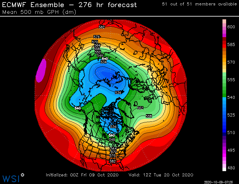
It doesn't look very realistic either....esp the ECMWF. It basically has almost no negative 5H anomalies. Scott and I have been wondering this for years....if that is why these models have trouble spitting out spatially representative anomalies. (i.e., we talked about years like 2014 and 2015 where they just refused to spit out downstream cold anomalies despite an EPO ridge from hell over AK/Yukon).
-
That's pretty hideous....lets hope NCEP is right as that would probably be pretty solid for New England.
-
Yeah if you have a suppressed Aleutian ridge, then it risks a pig in AK. We narrowly avoided it in 2007-2008, but did not in 2011-2012. '08-'09, and '10-'11 had very poleward Aleutian ridges....so did 2017-2018. 2016-2017 was moderately poleward.
-
I wish they had H5 instead of SLP, but that is def a -NAO for December....they all have an Aleutian ridge too which is not a surprise in a rapidly strengthening La Nina.
-
The study I did was based on the Hurrell SLP method (not CPC) and I used DJFM composite. Both methods have their flaws. As for including March in the winter NAO calc, you can make a case either way....but I included it at the time since it's a massive part of our snowfall climo. I know I don't have to tell you how many times a big blocking episode in March produced some whopper months.
-
2006 was one of the years where the excessive -NAO in October didn't foreshadow a -NAO winter. There's some others too because the "strong October -NAO = winter -NAO" correlation is somewhat weak. It's notable though because it reverses the overall inverse correlation we normally see. I think off the top of my head, some years that had strongly -NAO Octobers that also produced -NAO winters are 1946-1947, 1968-1969, 2002-2003, 2004-2005, 2009-2010 and since the last time I ran the numbers, I think 2012-2013 also may have had an excessively strong October -NAO that foreshadowed winter blocking.
-
I remember doing a little study on this back on EasternUSwx and found that extremely negative NAOs in October actually tended to favor a -NAO winter. It wasn't a high correlation at all, but it reversed the classic negative correlation. This was only through like 2009 though...not sure what the last decade had produced.
-
‘07-‘08 was also warm and wet. Not a blowtorch...was around +1ish for the winter.
-
I don’t think < -2C for a trimonthly is all that realistic. Maybe -1.7ish could happen.
-
Yeah that’s a decent chance for NNE to get first accumulation on that look. We’ll see if it holds over the next few days. Even if it’s not totally synoptic ala 12z Euro, cold ULL snow showers are a distinct possibility.
-
Yeah a little tough when you got Madison/Adams towering in your backyard, LOL.
-
Yeah that’s true. Even in garbage winters you’ll get moose fart upslope events like ‘11-12. We did have a pretty active December down here. 27”+ at ORH for the month...3 events after the big one early month. But Jan/Feb was about as bad as it gets before it actually got somewhat active again 2nd half of March and April. But by then it was a little too late to get really big events.
-
Last winter was pretty shitty up north wasn’t it?
-
Jeez that’s not really gonna cut it for a chunk of SNE either. Most years go below zero once you’re just a bit off the water in MA and even a lot of CT/RI.
-
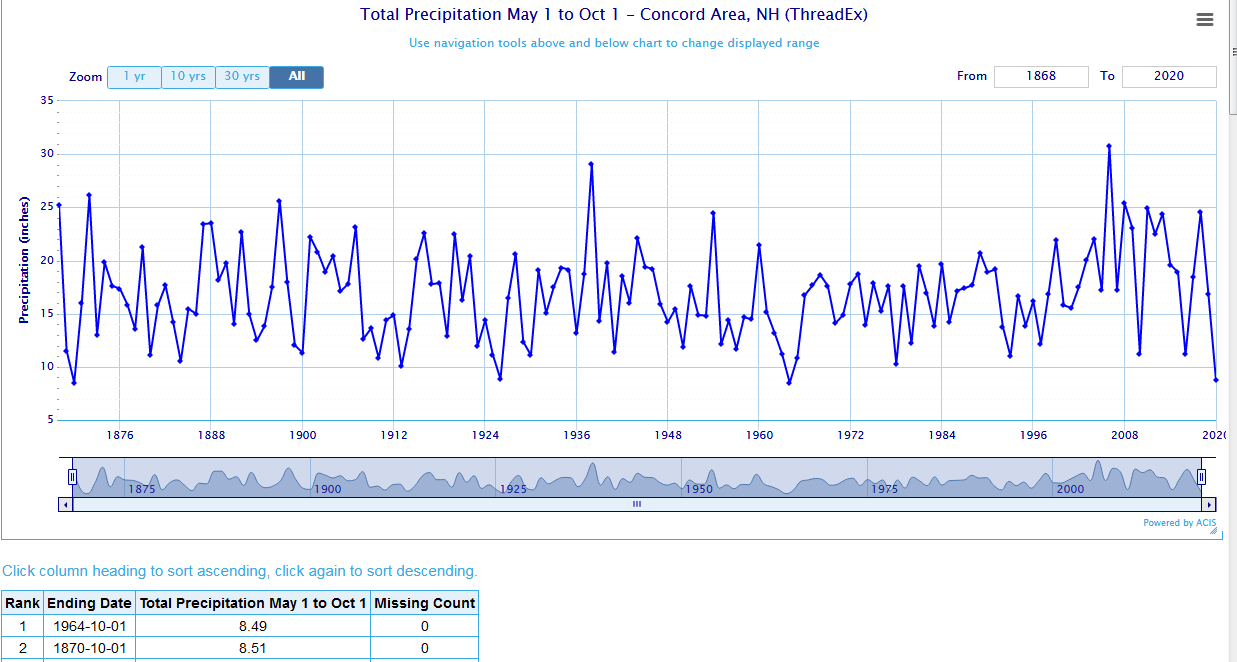
Pickles would have loved 1973-74....Dec 1973 alone had 5 (!!) cutters with heavy rainfall across a chunk of New England. That is not counting the ice storm on the 16th-17th....if you count that one (since basically east of ORH-CON was rain), then it would be 6 heavy rainers. There were several more scattered throughout the winter....that winter definitely is one of the exceptions to the rule that very high precip = lots of snow. Prob a top 10-15 precip winter but a horror show when it came to snowfall.
-
1973-1974 kind of shows what happens when a 2007-2008 look 'goes wrong"....everything ended up NW in N VT and upstate NY....even PWM to CON was utter garbage.
-
Yeah I'm sure there is absolutely a correlation with the dryness. We all know from a thermodynamic standpoint, the air will radiate heat more efficiently when in a dry environment.
-
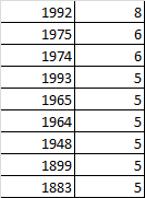
1963-1966 were the core of it. 1964-1965 was the peak.
-
2020 is up to 5 now....
-
Looking further ahead, the 2nd half of October looks like there will be some cold shots and that is perhaps the first threat for snow in New England outside of the mountain tops. This is the kind of pattern that could produce something in the typical favored early season spots.
-
The ETA model was the predecessor to the NAM....they actually renamed it the NAM while it was still the ETA, but the NAM became based off of the WRF model when they discontinued the ETA in 2006-2007 season. The ETA could run hot and cold. Sometimes it just knocked events out of the park...12/9/05 was one. Jan 2005 blizzard too. However, it had some epic epic failures too including 12/30/00 and it was putrid in the Feb 2006 storm. But overall it was a solid model and it had some fairly consistent biases that you could play off of as a forecaster.
-
I flew into Montrose back in Jan 2016 when I did Telluride. Small airport but it was super easy getting your stuff and getting out of there. I remember one of the old posters on the now-defunct epicski forum had snowfall totals by year for each resort and there was surprisingly less reliance on El Niño in Telluride than I would have first thought. I expected it to be more like AZ Snowbowl or Taos. El Niño is def best there but they have gotten smoked in many La Ninas too...they got destroyed in ‘07-‘08 and did very well in ‘08-‘09 and ‘16-‘17.
-
Once you are outside of the elevated interior in SNE, the winters are not going to be wire to wire in terms of pack retention. It just doesn’t happen. Maybe once every couple of decades. So for “good winters”, it’s either a 3-4 week blitz like 2011/2015/2009/1994/1987/1978/etc or it’s a longer drawn out winter with events in every month but some thaws in between. Winters like ‘00-‘01, ‘02-‘03, ‘04-‘05, ‘13-‘14, ‘17-‘18, ‘81-‘82, ‘69-‘70, ‘71-‘72 Sometimes you get lucky and get both in the same winter like 1995-1996. That had a 4-5 week blitz, massive thaws but events in Feb/Mar/Apr as well. Or even ‘60-‘61.
-
I think we can still use past climate to determine how likely a future event is...especially if we have pretty good knowledge of how the ambient environment has changed. So for example, we know there has been a 7% increase in water vapor with about a 1C increase in temps, so we can adjust the precip accordingly. Ditto for things like a heat wave or cold wave. Now, obviously for really rare one-off events like the '38 hurricane, October 2011 snowstorm, etc....it becomes a little harder to quantify return frequencies in a current world vs the past. Even using 30 year snowfall averages....they do change, but it's remarkably consistent when you think about it. They might change by 20% at most for a place like BOS? And BOS aleady is a fairly "high-variance" snowfall location. Lowest I've seen BOS is like 40" and the highest is like 48" for a rolling 30 year avg.