ORH_wxman
-
Posts
93,092 -
Joined
-
Last visited
Content Type
Profiles
Blogs
Forums
American Weather
Media Demo
Store
Gallery
Everything posted by ORH_wxman
-
Yeah I’m not buying first week of December. Too early imho as the air masses are putrid. I mean, anything is possible with perfect timing but I don’t think you are going to get the source region in better shape until post-12/5
-
Let’s hope that’s it instead of 1999-2000 or 2011-2012. Im hoping it’s closer to 1975-1976....garbage pattern for a time in November and the first half of December was repulsive with an AK pig but then it retrograded into an Aleutian low and we rocked the 2nd half of December. Huge pre-Xmas multi-wave event that gave BOS like 17” or 18”. Kind of weird that in contrast to typical Nina, that year produced an Aleutian low for quite a chunk of the winter (a lot of January had one too).
-
Gonna take some time though to reload Canada. First week of December will probably be a furnace across the CONUS even if we’re starting to see some changes in the PAC.
-
Less than 7 months until the sun angle decreases from its peak.
-
This pattern is absolute garbage. Once it becomes a little less hostile (signs of this happening as we go into early December) I’d expect some real threats to start happening for NNE.
-
Yeah anything before 12/5ish is probably going to have very little cold air. Best bet is post-12/10 on that look. Hopefully NNE and upstate NY can get an event or two before that though. It’s in our best interest to lay down some pack there.
-
Yeah down there I think you had 1/7-8/17 and 2/9/17.
-
Yeah feel free to start a new thread for it. Prob the easiest way. Maybe @dendrite can chime in.
-
This is pretty nice. One thing I personally like is seeing a few number values plotted on the actual map but not sure if that’s too difficult if you have so many obs.
-
I gotta find one from like 1/12 or so. I think it went way more nuts. What a disaster that was. For several runs it was basically showing a near-2015 pattern.
-
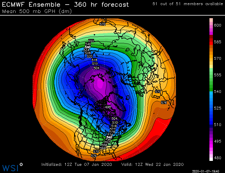
This isn’t bad at all. We’re going the right direction. Best EPS long range yet...still need to get this closer obviously and even that look is only the beginning of the change.
-
That’s a pretty nice look though if we can get it. Hopefully EPS trend toward that. They’ve been kind of straddling the line between hideous and something closer to GEFS.
-
Last 3 or 4 frames on EPS were encouraging. You could see this big height rise starting near AK/Aleutians.
-
I was taking a winter session class that year so I was actually there for the Jan 3-4 storm which gave ITH like 15”...one of only 2 synoptic storms over 10” while I was there (actually maybe PDII barely got there too)....the other was March 4-6, 2001 but that literally took like 3 days to get 16” so I almost don’t count that one. Lol. We did get a great streamer my freshman year on the backside of the Jan 25, 2000 bust. We had like 7-8” in 4 hours behind that storm. So the “total” was like 13” but we used LES for more than half of it. You were there for some excellent storms. Feb ‘66 was epic there.
-
That’s pretty awesome. My grandparents had a full nut-producing American Chestnut tree in their backyard in the 1980s and into the early 1990s. We noticed the trunk started cracking in about 1993 or 1994 and by 1995 it was clearly going to kill the tree so they cut it down. I didn’t realize until years later how relatively rare it was to still have a fully mature healthy tree like that as late as the early 1990s. But it made sense in retrospect because they lived out in the sticks and had a huge yard....and the tree was toward the middle of the yard away from any other trees. The isolation probably kept it alive for so long. I knew someone who had one that was healthy even a lot more recently than that but it eventually succumbed around 8-10 years ago.
-
My 4 years in Ithaca NY were like that. Of course, it drives you mad after a while because it snows for like 2 weeks straight and you have about 3” on the ground to show for it.
-
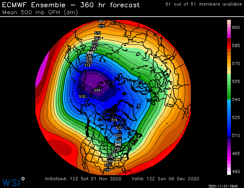
Yeah I'm hoping it doesn't migrate back though. The weeklies yesterday had it planting over AK for pretty much all of December. Weeklies can obviously be wrong (they've had some brutal stretches this year, including back in January), but you'd like to see the ensembles continue the trend over the next week. I'd like to see at least one transient ridge shoot up into Bering/AK just to get Canada reloaded. It's pretty torched. It could use a refresh. The PNA ridging would be a lot more effective with a fresh cold dump prior to it. But beggars can't be choosers I guess.
-
Yeah it's not a good pattern yet there but it is a lot better than what we've see before that. Hopefully we trend the PNA positive a bit more beyond 12/5.
-
Did you go on the statewide meetings back in August? My wife was on a couple of them and it seemed like the elementary school teachers in particular were pushing back a lot on the "100% remote learning, no compromises" type solution she was hammering home. At the end of the day, the district union reps seem to do more of the negotiating anyways, but it seemed weird that she was out of touch with a lot of the union base on that. Like, the teachers were absolutely concerned about safety, but so many were saying "we need to find a way to get into the classroom but safely"....esp the teachers of younger kids. For high schoolers, it felt a little less urgent.
-
Today is the first day I've had a little cautious optimism for December since maybe 10+ days ago. We've seen this trend toward a more serviceable looking pattern for a couple days now....so hopefully that lends some credence to it not being a model blio or one-off.
-
He's playing the reverse psychology game pretty strongly this year. Hey, at least he's not setting himself up for disappointment I guess if it actually ends up as a total ratter.
-
Even first week of December is pretty hostile from a climo standpoint...yeah we get a few large exceptions like last year, 2003, etc, but for the most part we really start getting historically better storms after the first week or so. Even in a lot of our fast start La Ninas like 1970, 1975, 2007, 2008, 2017, etc....the snows really come in more toward mid month or in the case of 2008 and 1975, less than a week before Xmas. It's still a positive sign to see the pattern trying to shuffle though in the first week of December because if it gets pushed out a week, then we're still only into mid-December when snowfall climo is ramping up quickly.
-
LOL...I like the October snow reference there. The dry humor is even better coming from Jspin considering how meticulous he is with statistics/data.
-
I was just going to ask what the tropical PAC was doing....and that might explain it. MJO itself seems to be all over the map depending on the guidance you use. Some of have it in the COD while others like the Canadian have it ripping into phase 7....but if there's a shift in the IO forcing, then it's probably enough to shake it up downstream.