ORH_wxman
-
Posts
93,092 -
Joined
-
Last visited
Content Type
Profiles
Blogs
Forums
American Weather
Media Demo
Store
Gallery
Everything posted by ORH_wxman
-
January 2026 regional war/obs/disco thread
ORH_wxman replied to Baroclinic Zone's topic in New England
I’ve had one double digit storm (and it was barely double digits) since Feb 2022. This truly feels like that 1988-1992 stretch except warmer (at least prior to last winter) and not quite as paltry on seasonal snow totals here…but close enough. Really could use a big storm to break the drought. -
January 2026 regional war/obs/disco thread
ORH_wxman replied to Baroclinic Zone's topic in New England
Monday doesn’t look that interesting unless northern stream digs a little more for a stronger IVT. Otherwise prob flurries or C-1”. -
New Years Day 2026 - 1st snows of the new year possible
ORH_wxman replied to Baroclinic Zone's topic in New England
That’s a pretty big hit for midcoast and downeast. Let’s grab 1-2” down here. Want to keep seeing that vort come in really strong. That always helps to compensate a little bit for a dry system coming in from a downslope direction. It increases the lift and tries to tug some moisture from the Atlantic. -
12/30/00 was a really annoying storm in central and east-central MA. Took forever to start (you can see how all the precip filled in west first despite it moving almost due north), and then once it got going it didn’t last all that long. It was heavy but then dryslotted pretty quick.
-
January 2026 regional war/obs/disco thread
ORH_wxman replied to Baroclinic Zone's topic in New England
Euro keeps trying to show an IVT associated with the offshore storm on 1/4 as a northern stream shortwave moves over our region to cause it…wouldn’t be much but another inch or two could happen around that time. -
New Years Day 2026 - 1st snows of the new year possible
ORH_wxman replied to Baroclinic Zone's topic in New England
PVA is pretty damned strong in this. That’s a vigorous vortmax. Could be a quick moderate/heavy burst in there with that. -
January 2026 regional war/obs/disco thread
ORH_wxman replied to Baroclinic Zone's topic in New England
ORH has been slightly BN for snowfall in December but not by a lot. November was a goose egg though so seasonal is behind by a 2-3” more. -
January 2026 regional war/obs/disco thread
ORH_wxman replied to Baroclinic Zone's topic in New England
Need a panic thread. Not sure I can tale the toddler whining much longer. -
New Years Day 2026 - 1st snows of the new year possible
ORH_wxman replied to Baroclinic Zone's topic in New England
Seems like most should get measurable but 2”+ will probably be in isolated pockets or out on/near Cape. -
January 2026 regional war/obs/disco thread
ORH_wxman replied to Baroclinic Zone's topic in New England
Nothing big. It did show a light snow event on 1/4. 1/6 is still there too actually but again, not a biggie. -
January 2026 regional war/obs/disco thread
ORH_wxman replied to Baroclinic Zone's topic in New England
I always tell people that overselling CC is just as anti-science as denying its existence. People should recognize both of those. But I’m with @dendrite….this isn’t the time to be clogging up the main thread with this debate. -
January 2026 regional war/obs/disco thread
ORH_wxman replied to Baroclinic Zone's topic in New England
The irony of getting into a global warming debate when we’ve been like -5 so far this winter. You’d think it would be in a +5 winter. -
January 2026 regional war/obs/disco thread
ORH_wxman replied to Baroclinic Zone's topic in New England
2009-2011 was the lowest 2-year NAO on record -
January 2026 regional war/obs/disco thread
ORH_wxman replied to Baroclinic Zone's topic in New England
Ensembles did get worse for both threats too just to be clear…but they didn’t eliminate them. I’d like to see it a bit healthier at 12z. -
January 2026 regional war/obs/disco thread
ORH_wxman replied to Baroclinic Zone's topic in New England
I know we were told that the NAO was going to be predominately positive due to global warming….we went through a big +NAO period in the 1980s/1990s and lots of papers came out about it being attributed to global warming. Then we got a huge decadal period of -NAO between about 2000-2001 and 2018 which coincided with the snowiest 15 year stretch on record in many SNE stations. It’s taught me not to have knee-jerk reactions about 5 or even 10+ trends and trying to extrapolate based on those. They just aren’t very predictable. A lot of climate weenies love to undersell the stochastic aspect of many of these patterns. It doesn’t mean we’re not warming…we can measure that we are and the literature is pretty sound about it on the whole…but it means other pattern attributes and sensible wx isn’t necessarily as easily predictable or understood by climate modeling. -
January 2026 regional war/obs/disco thread
ORH_wxman replied to Baroclinic Zone's topic in New England
Maybe. I wouldn’t be tossing a system that is over a week out though. And especially not one that is 10 days out. They may not happen. If that ridge rolls over, we’ll actually get mild for a few days, and that could set off some melts in here but there’s a very strong signal for a reload of the ridging out west and up into AK beyond that both on EPS/GEFS and the weeklies, so I think we’re going to continue to have chances. Obviously we want to start hitting on a few…we’ve already done plenty of cold with little snow this year. -
January 2026 regional war/obs/disco thread
ORH_wxman replied to Baroclinic Zone's topic in New England
1/8-9 looks worse today because the ridge is further east now. Need that further west. I’d still watch both that system and 1/6 though. There’s still a signal for both on the ensembles even if it’s not as strong. -
January 2026 regional war/obs/disco thread
ORH_wxman replied to Baroclinic Zone's topic in New England
Right…there’s a reason they are like 1 in 50 or 1 in 100 year storms instead of 1 in 500 -
January 2026 regional war/obs/disco thread
ORH_wxman replied to Baroclinic Zone's topic in New England
We’ve talked about this before, but there’s probably some perfect chain of events that produces a sub-950 bomb southeast of LI starting from relatively higher pressure….preceded by some sort of high-thermal gradient overrunning scenario that lasts 24+ hours before the slow moving shallow trough is injected with polar/arctic energy, deepens extremely rapidly, and produces 5-foot totals once you add the entire thing up. Yeah…1 in 500 years maybe? But it’s not zero. -
January 2026 regional war/obs/disco thread
ORH_wxman replied to Baroclinic Zone's topic in New England
For me, that bigger storm can win but it has to be pretty rare. Taking a 15” storm that melts in 3 days over a handful of 5-6” events with prolonged cold is an easy no for me. But if we’re talking a 30-burger over 3 foot-longs, sure…the 30-burger is pretty special. -
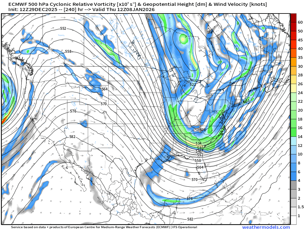
Ice Ice Baby December 28-29 Storm Discussion
ORH_wxman replied to Baroclinic Zone's topic in New England
Radar looks good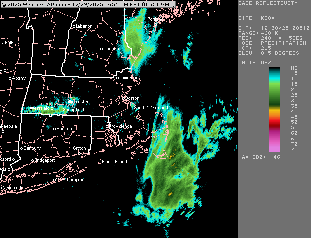
-
January 2026 regional war/obs/disco thread
ORH_wxman replied to Baroclinic Zone's topic in New England
Most people here would probably take 2-3 storms that add up to 25” with long duration colder temps than a 19” storm that melts away in 4 days. But I can see those who just enjoy the storm picking the 19-spot. Obviously if we waste a good pattern with very little snow, we’d all take the 19 burger. -
Ice Ice Baby December 28-29 Storm Discussion
ORH_wxman replied to Baroclinic Zone's topic in New England
Looks pretty decent south side of BAF/CEF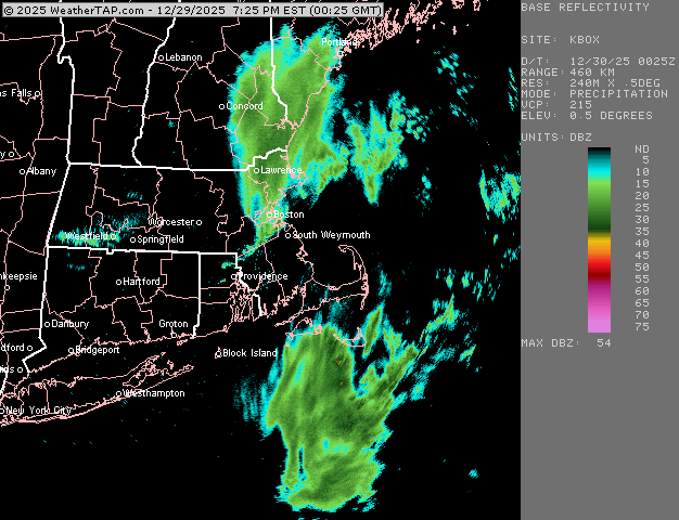
-
January 2026 regional war/obs/disco thread
ORH_wxman replied to Baroclinic Zone's topic in New England
1/6 could morph into something worth tracking if we can get it inside 6 days. The larger signal is 1/8-9 but that has a ways to go. But overall a good pattern coming up. Nice to have in early January for once. Feels like we’ve been fighting garbage patterns in early January so often over the last decade or even longer. We had a lot of good early Januarys in the 2009-2014 time frame. Since then I feel like maybe only 2018…maybe 2024 if we want to count that one threat on 1/7 but it really wasn’t a cold pattern at all. -
January 2026 regional war/obs/disco thread
ORH_wxman replied to Baroclinic Zone's topic in New England
Yeah euro still generates a system on 1/8-1/9 but it’s a bit strung out and weak going almost due north and scraping eastern areas. It doesn’t take much mental gymnastics to see that thing being much stronger and more coherent. The PNA ridge is pretty amplified which is going to want to force a lot of energy to pile up around the base of the trough.