

ORH_wxman
-
Posts
93,092 -
Joined
-
Last visited
Content Type
Profiles
Blogs
Forums
American Weather
Media Demo
Store
Gallery
Everything posted by ORH_wxman
-
No the airport is not north. It’s west side over by Tatnuck Sq. Winter hill is north-northwest side near the Holden line.
-
And i was telling you +8 for two weeks isn’t close to record warmth. You’d need to go up a lot higher than that.
-
You’ll need like +14 or 15 for a two week stretch...which would require the Davis Strait stuff to disappear. Anything’s possible but I ain’t seeing it. Maybe Caribou.
-
Oh yeah...he will def want to PM me. There’s massive difference within the city...there’s a definite N to S gradient too overall but also elevation obviously.
-
Dec (Edit: Jan1/..2 ) multi-faceted ptype mess potential...
ORH_wxman replied to Typhoon Tip's topic in New England
Wolf not howling tonight? -
He might have been issuing a forecast for the Davis Strait or northern Quebec.
-
They are a little more bullish on a Davis Strait block...and we will need it for sure the first 10 days of the month with the garbage PAC. Hopefully a better PAC materializes beyond that.
-
Underdog that it will end up a big storm, but can't rule it out. Marginal airmass (though at least it appears better than 12/5 as modeled) and a lot of shortwaves in the flow don't allow for much margin.
-
Euro develops a legit Davis Strait block in clown range around 1/7. We'll see if that can help keep things underneath us until the PAC improves. We will need it so hopefully it has the right idea.
-
I have to admit, that would send Kevin on an MLK-2010 style melt
-
H5 low tracks in Ottawa, lol....tries to redevelop SE, but I'll take this with a grain of salt obviously until we get closer.
-
Yeah it's a sloppy development....initial pulse of PVA is well west which is a red flag to me, but it doesn't really have room to amplify so it redevelops east....the QPF and clown maps will look fine, but there's a lot of moving pieces that will change over the next few days.
-
Ugly evolution on the euro for 1/4...but system is still there for sure. Something to watch.
-
Yeah that is a pretty major storm actually...prob warning snows for a chunk of the area if it ran another 6-12 hours out...esp eastern half of SNE
-
It's a little bit colder as modeled, which could potentially be a big difference in sensible wx.
-
It's good enough for interior SE NY and interior SNE.
-
Dec (Edit: Jan1/..2 ) multi-faceted ptype mess potential...
ORH_wxman replied to Typhoon Tip's topic in New England
I've mostly agreed with Scott on this threat....meh for SNE but there was an outside chance that interior spots like ORH to the berks could see something more interesting. Euro has never looked good for this icing threat in SNE....which is why I haven't really posted much on it. We saw some other guidance toy with the idea of a more impactful event, but they have trended toward the Euro (kind of predictably IMHO). Still have to watch for a few hours of glaze over the interior....even a little glaze can be a hazard. But outside of that, I don't see much. You'll have to go much further north to get some accumulating snow that breaches advisory threshold. -
Yeah don't count on building sustained pack until the PAC gets better. If 1/4 ends up pretty big, then it might last, but otherwise, we wait.
-
Yeah if 1/4 doesn't produce, then it's prob shades closed for SNE until at least 1/8-1/10ish....something might pop before that, but it looks like an uphill battle with such a terrible PAC and the NAO blocking isn't really set up yet.
-
EPS trying to bring it back a little. I know the OP run has toyed with the idea, but you'd like to see some bigger solutions on other guidance. GGEM was showing it a little too.
-
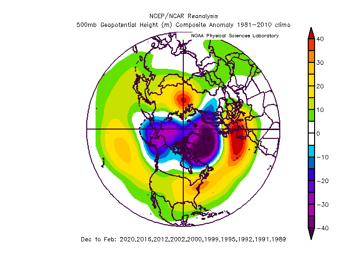
Scott, here is the last 30 years or so of our garbage winters. The NAO and the AK pig stand out well.
-
Yeah not sure why he’s implying the PAC looks like those composites. The PAC looks way worse than that over the next 10-12 days...now, it may improve after that, which is reason to get more optimistic assuming west-based blocking develops.
-
It’s often behind the grinch storm we typically see, lol. But there wasn’t much cold behind this one. Doesn't look like any true arctic air for the foreseeable future. May have to wait until mid-month or later.
-
EPO never gets great on weeklies but it doesn’t have to if the NAO/AO ends up like it depicts. It goes into a bit more of a neutral state and the PNA ridging pops a little more. It’s not a cold pattern up here but it is a good one for snow events. Definitely a cold pattern down south though. Weeklies could be wrong though. They don’t have a lot of skill beyond week 3.
-
Weeklies gone wild from mid-January onward....PAC gets better and NAO blocking looks more classic. Let’s hope it is right.

