ORH_wxman
-
Posts
93,092 -
Joined
-
Last visited
Content Type
Profiles
Blogs
Forums
American Weather
Media Demo
Store
Gallery
Everything posted by ORH_wxman
-
I have found SR to really shine late in the season. Because it holds snow so well, all their steeps are slathered in snow well into March and early April. The only one that struggles a little bit is Quantum Leap because it’s one of the few steep trails that face west (it’s on the back side of north peak) and it also has no snow making on it. SR because of the mountain design can spread their crowds out really well too...so even a crowded day isn’t terrible when all the lifts are turning. But yeah, going into the trees off Oz and Aurora peaks can be really fun when they get a nice synoptic dump. Or if you really like steep bumps, do shockwave on whitecap peak after a nice snowfall.
-
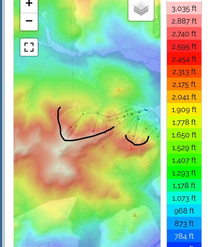
The Loaf and Saddleback also have really good elevation. Saddleback base elevation is like 2100 feet, LOL. That’s like Kmart levels except you are up in Rangeley where nothing melts even at lake level, nevermind 2100 feet. Sugarloaf is like 1500 and even further northeast into The boondocks. Sunday River is actually kind of unique in how low their base elevation is. I think base of whitecap is like 850ish to 900.
-
I’m glad it’s finally starting to pay off in the snow department. The upslope you report there is even a little better than I had envisioned. Seems like you are almost on par with Alex for upslope...just a smidge less maybe. You cleaned up on that last synoptic storm too with the east flow.
-
Yeah SR doesn’t average a ton but it holds the snow amazingly due to its shape and the fact that it’s already deep into CAD territory. It’s kind of like a giant horseshoe that faces northeast. The low elevation snow depths there are usually unmatched anywhere else at similar latitude in New England. I routinely have seen 40-50” depths at like 600-800 feet there in late winter.

-
The bread and butter you were eating earlier this month said “Made in MD: expiration 2/10/10”. You got some NNE bread and butter finally.
-
Wildcat and Bretton Woods have the best views of any New England mountains ive skied.
-
Agree with Scooter on the wind at Cannon. It is awful there...every single time I’ve been in that peak it’s brutal. The terrain is amazing but the wind definitely has a detrimental effect on coverage. I think that’s part of their snowfall issues too. Like look at MWN. There’s a zero percent chance they average “only” 260” of snow if we could theoretically catch all the snow that falls there. But we can’t and it blows off into the ravines. Cannon isn’t the best snow spot anyway, but likely a higher percentage of their snowfall just gets nuked off the mountain face by wind than other mountains...and that mountain face is so exposed too where the trails are. Not many sheltered spots for it to collect.
-
Looked like 18z EPS were coming in more amped for 1/29 though the 18z run stops at 144h so couldn’t see further. But comparing with 12z EPS it looked noticeably better....still needs some work but at least time is on our side for that one.
-
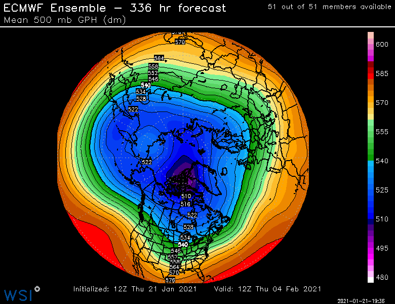
18z EPS north of 12z. Still would like to see the primary get basically into CLE. Right now it’s getting almost to PIT.
-
It was a good sign when the 12z EPS didn’t go south after the OP did.
-
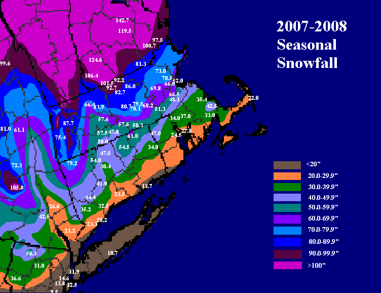
That mesoband actually shows up in the seasonal totals down there...you can see a little max near PYM and the canal while off to the west near EWB was clearly less
-
I have a couple radar loops of that one posted on my computer downstairs. I’ll post them in here tomorrow. I think places near PYM and the canal had close to a foot in that while 15-20 miles NW had like 2-4”. Lol. I remember a really intense band just crushing that area for hours.
-
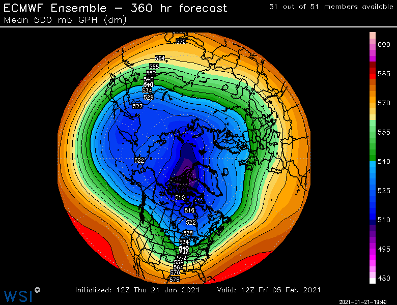
18z euro went back north again. Can only see out to 90h though but clearly north of 12z through that time. Hopefully EPS bumps north too.
-
Guys go into the banter thread to complain about moderation. There’s probably nothing worse in a pattern thread than whining about which posts were deleted and which ones weren’t.
-
They are ok....-PNA/-NAO through 3rd week of Feb and then it seems to transition to more gradient with lower heights in SE Canada by end of month.
-
EPS still trying to get more ridging out west for early February....we'll see if that sticks because that would provide a chance for something bigger. Note the lower heights down in the gulf....less SE ridge and less meat grinder.
-
EPS actually looked slightly north of 06z for 1/26
-
Yep, we've had plenty of similar patterns that produce...I'm talking longwave patterns. Obviously the synoptics haven't worked out. But nobody cares unless it's snowing, lol. It's like trying to convince people in northern CT or interior MA that January 2006 was a putrid pattern....2 feet of snowfall, lol.
-
We are due for the latter too. Anyways, I def wouldn't sell 1/26 yet. Not like the Euro went way south...it was a subtle change with the lobe in central Canada and those seem to flip around each run.
-
Fatties
-
The blocking is going to run the show. Whatever happens up there will determine how far north this one gets. You could see on this run that the western PV lobe in central Canada got elongated and stretched more which then linked up with the Nova Scotia low and made it tough to get downstream ridging.
-
Meat grinder this run. It's a subtle change, but when you're on the edge, it means a lot in sensible wx.
-
Euro looks like it's gonna be more suppressed this run for 1/26.
-
ORH with the rare moderate snow obs these days KORH 211754Z 21008KT 1/2SM R11/3000V4500FT SN FZFG VV012 M05/M07 A2963 RMK AO2 SLP051 P0001 60001 T10501072 11039 21089 56029
-
Way north....thats advisory into C NH.