

ORH_wxman
-
Posts
93,099 -
Joined
-
Last visited
Content Type
Profiles
Blogs
Forums
American Weather
Media Demo
Store
Gallery
Everything posted by ORH_wxman
-
3-4" would feel like a foot at this point.
-
Thing runs into a total brick wall. Pretty nice ML snows though for SNE....advisory type event.
-
Raining in CLE at 132 hours....how about that? Might be glad we have the block after all.
-
Yeah hard to imagine this whiffing....there's a lot more downstream ridging for it to work with this run.
-
Euro def more zonked this run for sure....lets see if it's enough this run to get the goods into New England.
-
Great area though if you like golf. They stay open later and open earlier. Used to drive me nuts back when I played all the time....I'd be waiting for courses to open in ORH and they had been open for 3 or 4 weeks already down there. Prob why those schools tend to do better in tournament golf back when I played in high school. I played for St. John's Shrewsbury and we had a good team, but we always had trouble for those SE MA and Cape schools. We always annihilated the northern schools.
-
It's definitely a risk with this block....but sometimes these ejecting SWFE type systems will trend north as we get closer....even when there's some confluence. We'll just have to wait and see because the subtleties of the block up north mean a lot and aren't likely to be handled great by model guidance. GFS was a garbage solution, but GGEM trended north into an advisory event for pike-south and while Ukie trended south, it is still solidly north of the new GGEM solution. In addition, the 06z EPS trended solidly north, so we will see if the 12z run is any better. If it is, then there's definitely some more hope for this system.
-
Warm bum-bums in the car seat is Tip's favorite time of the winter.
-
00z was obscenely north...it was going to sleet well into CT.
-
Yeah that would work for SNE....prob not a huge event, but at least solid advisory or low end warning. Something to get the ground covered for the cold pattern.
-
GGEM came quite a bit north with 1/26....we'll see what the other foreigns do before linking our doom and gloom fate to the GFS.
-
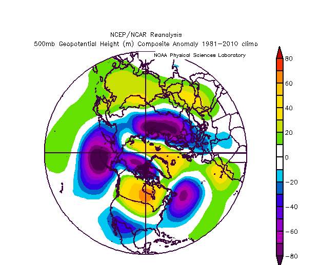
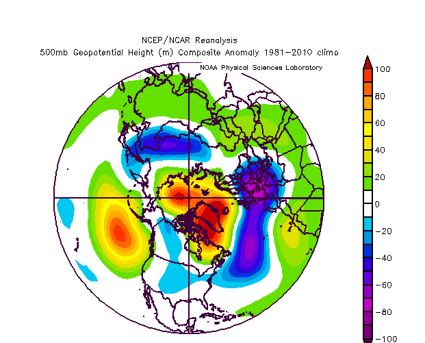
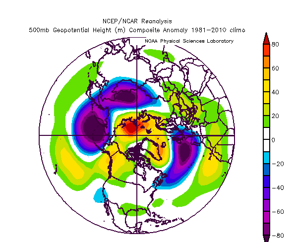
ORH: 2000-2001: 102.1" 2012-2013: 108.9" 1986-1987: 93.6"
-
There are no past snowstorms being discussed right now...it is pattern talk....the 3 composites I posted are 2000-2001, 2012-2013, and 1986-1987....all blockbuster snow years in SNE. They had some similarities to the Atlantic pattern of 1979-1980 but they produced. The pattern currently being forecasted resembles some similarities too.
-
Last one
-
And this one
-
Here's a good one
-
Yeah....this is the pattern for the mountains. I think I mentioned last week how good of an upslope pattern was coming. It will fire back up too tomorrow after a short lull and could go into Saturday morning. Would still be nice to grab another synoptic event in there, but it's come a long way since last week.
-
Yeah.....Ashland is not a bad spot....one town over from me and a bit more affordable than Holliston....though Holliston is more affordable than Southborough/Hopkinton/Westborough. Medway to my south isn't terrible....'nor is Millis. Both relatively affordable. If you don't mind the larger town feel, Milford/Framingham are both way more affordable, but schools aren't as good (if Jay is planning a family).
-
There must be some decent rates in the heart of that stuff in between the ASOS stations
-
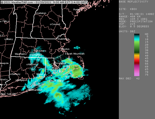
Obs thread for snow showers today https://www.americanwx.com/bb/topic/54401-snow-shower-obs-120/
-
Starting this thread for obs on the snow showers today. Pretty good WINDEX parameters, but the one ingredient missing is a really sharp zone of lift. However, big LI spike and some PVA should help. Lapse rates are about as high as you will ever see them in winter with the column near saturation so if some squalls can develop, they will get quite heavy I think. TTs are near 60 this afternoon before falling. Best chance for heavy squalls will be mid afternoon for central/western areas and late afternoon for eastern areas.
-
RAP/HRRR are actually pretty nice looking later on for eastern areas....yes, I know some of you don't give a crap.....but for those who do, worth watching for some decent squalls. TTs near 60 are no joke. Obscene lapse rates.
-
South definitely favored. Still a lot of time though being 6+ days out.
-
06z EPS came pretty far north with 1/26.....should be noted that the 00z Ukie was wayyy north. Can't sell that one yet.
-
Our little 3 bedroom in Holliston built in 1966 has gone up like 100k+ in 4 years since we bought it. We bought it for 345k and most appraisals would put it at 450 now. It’s insane. All the new construction single family homes around here are going for 700+ and most of them over 800.


