ORH_wxman
-
Posts
93,092 -
Joined
-
Last visited
Content Type
Profiles
Blogs
Forums
American Weather
Media Demo
Store
Gallery
Everything posted by ORH_wxman
-
Tamarack throwing his laptop against his healthiest spruce tree while Tblizz bitches his way to 6"+ of mashed potatoes.
-
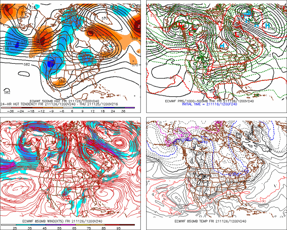
Gonna have to watch for shenanigans with that block next week....even 00z Euro retro'd the storm enough to get accumulating snow into SNE, albeit not as much snow as the GFS had. It's not a likely outcome, but with a block like that you have to keep an eye open.
-
Deepest pack to your north in ORH was probably March 2001 but you were likely too far south for that month to eclipse the Jan '96 pack....though you must have come close in early Feb 2011. If you go back far enough, the pack was probably rivaled in Feb 1961. January 1987 got really deep too in N ORH county....prob 40-something inches. I think I measured 43-44" in February 2015, but that was a couple inches shy of March 2001. January 1996 was similar to 2015.
-
It's only 11/17....this is more for the pattern at the end of November....we could easily reload a good December pattern a week to 10 days into the month. The T-day weekend pattern doesn't look as cold though for sure right now.
-
Pulling the plug on what?
-
Ensembles trended worse too....the block in the Atlantic keeps us from torching, but we don't need this to keep trending worse as we head into December. The EPS do try to pop a bit of PNA ridging again at very end of Nov and near 12/1, but the lower heights up in AK persist.
-
That's an ugly end to the OP Euro run with a nice one-eyed pig setting up over the Bering Region...hopefully that changes again.
-
I'd have to imagine that is just bad data on there? They'll prob correct it. The Mansfield stake is in a sheltered area there amongst the evergreens, right? You'd have to think there is at least half a foot OTG there.
-
Yeah im skeptical of next week's storm mid-week, though I guess if it gets captured perfectly we could have a surprise. It feels like that 11/27-11/30 window might be a little more favorable for this month but things can shift. I'm hopeful the -NAO can go into the first half of December as well because the Pacific doesn't look great to start December, however, because there was already some good cold into Canada, a decent -NAO would suffice for threats. The PAC look has been really volatile the past few days though, so that's something that will probably change on future runs.
-
Yes it could end up a transient ridge instead of a full block. But there is pretty heavy ensemble support for the block to develop so I don't think it's just something random on an OP run. All models are seeing something. Whether that trends better or worse as we get closer is obviously still up in the air. It's a very good spot to have a block though....esp this early in the season when the polar jet is still north of mid-winter climo....you want something to force shortwaves underneath our latitude and a well-placed block is probably the most efficient way to do that.
-
Gonna need the good Atlantic look to stay on track....PAC side has trended worse for sure. But that NAO block can make up for a lot of sins if we can get it.
-
Another OP run showing a monster block.....yeah, it's in clown range, but the cross-model appeal and ensemble support is pretty good.
-
Yeah that was Nov 14-15, 1995 I think...we actually started as snow in that in ORH...but only for a brief time. Had a quick half inch or so and then a lull....then when the main precip shield came in during the afternoon it was 40F rain.
-
Massive slingshot job on the Euro....if that happens a little earlier then it could be pretty decent snow. Even as is, it does get accumulating snow into a good chunk of New England...even if most of it is sub-advisory stuff outside the mountains.
-
Didn't you get a 20-burger in the Lindsay Storm too earlier that month?
-
Lol.
-
That is an absolute beast -NAO block on the GFS at 12z. We've seen some runs do this from time to time and if a block like that forms, then it changes the tenure of the pattern from "pretty good" to "extremely favorable" for winter threats to end November and start December.
-
You'd prob need some elevation in this one since the airmass is dogcrap. If it "pans out", it's the type of thing where it maybe snows light to moderate at 33-34F for maybe 3-4 hours or so...so you get a slushy inch at elevation and prob white rain elsewhere.
-
Very possible most of us don't see any accumulating snow until December....that isn't super uncommon. It's not the norm for the interior from your area down to ORH/interior SNE elevations, but it does happen now and again. That said, the pattern does look pretty decent for the end of the month, so Nov 25-30 is definitely in play. BTW, don't totally sell the anafront deal on late Thursday night/predawn Friday. I wouldn't expect a real storm, but certainly a C-2" is possible...esp for interior elevations.....if were talking about first measurable snow for some.
-
08-09 was severely -PDO. 05-06 was not. But this year is on another level. I think Nick posted last week that this might be the most negative since the 1955-56 Niña.
-
Yeah and so did December 2005 and Jan 2009 for a couple others off top of my head. I think even Dec 2017 may have been positive but not a raging +PNA like ensembles show. Getting a raging +PNA in a Niña is very good though...even if just for a few weeks. Lots of northern stream goodies for us.
-
Yes. Doesn’t mean there can’t be a torch day in there if we get a storm cutting to the west but the overall pattern that week is definitely below normal temps on the mean. Esp after about Monday/Tuesday.
-
That’s a weenie pattern to end the month and begin December. Big -NAO and +PNA. Not sure how long that PNA will hold given our current enso/PDO state but that is what you want to see...esp early in season when you have less wiggle room.
-
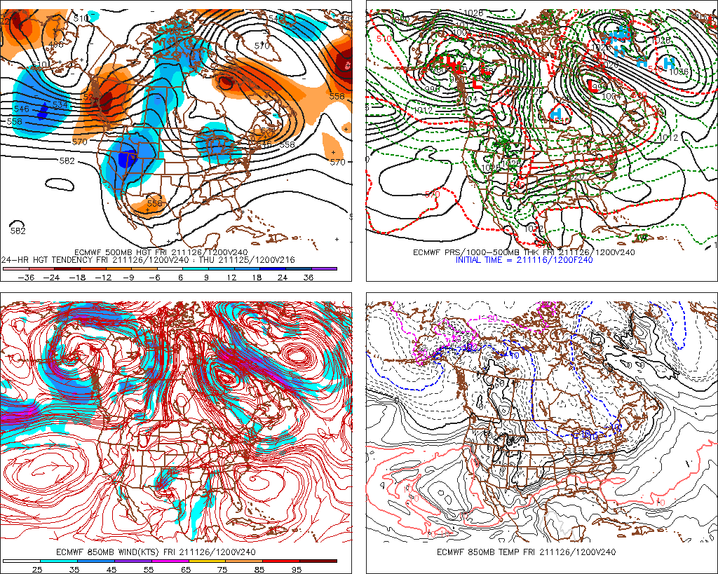
Nice little inflow going on looking at radar. Some of the peaks could get a quick lashing
-
Should flip any minute now based on sfc and 925 analysis. Wonder if you get a burst of moderate for an hour or two.